Wildcat Marsh Trail & Landfill Loop Photos


You might also consider
More like Wildcat Marsh Trail & Landfill Loop
Recommended Reviews - Wildcat Marsh Trail & Landfill Loop
Start your review...

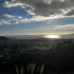
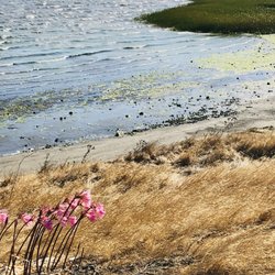
Just up the Richmond Parkway, Point Pinole provides a far more scenic walk along San Pablo Bay as does the San Pablo Bay Regional Trail between Pinole and Rodeo. Then there's this section of the Bay Trail that fills a gap between Point San Pablo and Point Pinole. I applaud the effort here, but it's not the most attractive part of town. It sits on the edge of an industrial area where there are pools of wastewater, a field of solar panels, and Garbage Mountain. Yes, it's called Garbage Mountain because it was previously a dump. Fortunately there isn't any heavy lingering odor, but you will see and hear a lot of rumbling trucks from Republic Services Recycling while you walk on the Landfill Loop portion. The upside is that much of the trail sits next to the bay where the only distraction are all the darting anorexic squirrels. On the downside is the first part of the trail from the eerily vacant parking lot at the Wildcat Creek trailhead. It's a long stretch of loose gravel without much visual relief before you even get to the loop. It will definitely take up a big chunk of your FitBit step quotient if you follow the entire route. RELATED - Up for a hike? Here's a collection of trails I've walked and reviewed: https://bit.ly/2OrC8nU read more


More info about Wildcat Marsh Trail & Landfill Loop
Parr Blvd
Richmond, CA 94801
Directions
Hours
Outdoor Amenities
You might also consider


Wildcat Marsh Trail & Landfill Loop - hiking - Updated June 2026
Best of Richmond
People found Wildcat Marsh Trail & Landfill Loop by searching for…
Fun Things to Do in Richmond, CA
Walking Trails in Richmond, CA
Abandoned Places in Richmond, CA
Regional Parks in Richmond, CA
Places to Take Pictures in Richmond, CA
Free Things to Do in Richmond, CA
Scenic Places to Walk in Richmond, CA
Empty Parking Lot in Richmond, CA
Running Trails in Richmond, CA
Beautiful Views in Richmond, CA
Walking Groups in Richmond, CA
Off Road Trails in Richmond, CA
Off Leash Dog Hikes in Richmond, CA
Trending Searches in Richmond, CA
Amusement Parks near Wildcat Marsh Trail & Landfill Loop
Beaches near Wildcat Marsh Trail & Landfill Loop
Black Owned Nail Salons near Wildcat Marsh Trail & Landfill Loop
Boat Rental near Wildcat Marsh Trail & Landfill Loop
Cliff Jumping near Wildcat Marsh Trail & Landfill Loop
Creeks near Wildcat Marsh Trail & Landfill Loop
Dog Friendly Trails near Wildcat Marsh Trail & Landfill Loop
Fishing Spots near Wildcat Marsh Trail & Landfill Loop
Free Kids Activities near Wildcat Marsh Trail & Landfill Loop
Jet Ski Rental near Wildcat Marsh Trail & Landfill Loop
Lakes near Wildcat Marsh Trail & Landfill Loop
Outdoor Activities near Wildcat Marsh Trail & Landfill Loop
Pick Your Own Farms near Wildcat Marsh Trail & Landfill Loop
Picnic Parks near Wildcat Marsh Trail & Landfill Loop
Public Shower near Wildcat Marsh Trail & Landfill Loop
Rock Quarry near Wildcat Marsh Trail & Landfill Loop
Running Trails near Wildcat Marsh Trail & Landfill Loop
Scenic Drive near Wildcat Marsh Trail & Landfill Loop
Secluded Spots near Wildcat Marsh Trail & Landfill Loop
Soccer Store near Wildcat Marsh Trail & Landfill Loop
Splash Pad near Wildcat Marsh Trail & Landfill Loop
Strawberry Picking near Wildcat Marsh Trail & Landfill Loop
Sunrise View near Wildcat Marsh Trail & Landfill Loop
Swimming Holes near Wildcat Marsh Trail & Landfill Loop
Swimming Lakes near Wildcat Marsh Trail & Landfill Loop
Swimming Pools near Wildcat Marsh Trail & Landfill Loop
Watch Sunset near Wildcat Marsh Trail & Landfill Loop
Browse Articles
Browse Nearby
BEST of Richmond, California Restaurants near Wildcat Marsh Trail & Landfill Loop
BEST of Richmond, California Coffee near Wildcat Marsh Trail & Landfill Loop
BEST of Richmond, California Walking Trails near Wildcat Marsh Trail & Landfill Loop
BEST of Richmond, California Things to Do near Wildcat Marsh Trail & Landfill Loop
BEST of Richmond, California Parks near Wildcat Marsh Trail & Landfill Loop
BEST of Richmond, California Breakfast near Wildcat Marsh Trail & Landfill Loop
BEST of Richmond, California Hot Springs near Wildcat Marsh Trail & Landfill Loop
BEST of Richmond, California Campgrounds near Wildcat Marsh Trail & Landfill Loop
BEST of Richmond, California Day Trips near Wildcat Marsh Trail & Landfill Loop
Browse Brands
Related Searches in Richmond, CA
Affordable Kayak Rental Services in Richmond, California
Best Fishing Locations and Guides in Richmond, California
Best Nature Trails for Hiking in Richmond, California
Best Places for Horseback Riding in Richmond, California
Check Out Off Road Trails in Richmond, California
Discover Dog Friendly Trails to Explore in Richmond, California
Discover Kid Friendly Hiking Trails in Richmond, California
Discover Scenic Hiking Trails in Richmond, California
Discover Scenic Mountain Bike Trails Near Richmond, California
Discover Scenic Waterfall Spots in Richmond, California
Discover Top Nature Parks to Visit in Richmond, California
Discover Walking Parks in Richmond, California Near You
Discover a Hiking Trail in Richmond, California
Discover the Best Night Hike Trails in Richmond, California
Dog-Friendly Hikes With Dogs in Richmond, California
Enjoy Camping Adventures Around Richmond, California
Enjoy Kayaking Adventures in Richmond, California
Enjoy Tent Camping Spots Around Richmond, California
Enjoy a Beautiful Waterfall Hike in Richmond, California
Enjoy a Peaceful Nature Walk in Richmond, California
Enjoy the Best Picnic Spots and Ideas in Richmond, California
Enjoy the Best Walking Path in Richmond, California
Enjoy the Best Walking Trails in Richmond, California
Explore Beautiful Parks and Green Spaces in Richmond, California
Explore Easy Hikes Perfect for All in Richmond, California
Explore Fun Activities to Do in Richmond, California
Explore Popular Campgrounds Near Richmond, California
Explore the Best Beach Spots in Richmond, California
Explore the Best Swimming Holes Around Richmond, California
Explore the Best Trail Options in Richmond, California
Family Friendly Hiking With Kids in Richmond, California
Find Beautiful Views in Richmond, California
Find the Best Parks for Picnics in Richmond, California
Find the Best Scenic View Locations in Richmond, California
Great Places to Walk in Richmond, California
Hike the Popular Waterfall Trail in Richmond, California
Hiking Trails With Waterfalls in Richmond, California
Off Leash Dog Hiking Trails in Richmond, California
Plan a Scenic Drive Route Near Richmond, California
Popular Outdoor Activities to Try in Richmond, California
Popular Picnic Spots to Visit in Richmond, California
Safe River Swimming Areas in Richmond, California
Safe and Fun Parks for Kids in Richmond, California
Top Climbing Spots and Gyms in Richmond, California
Top Paddleboarding Activities in Richmond, California
Top Running Trails to Explore in Richmond, California
Top Swimming Lakes to Enjoy in Richmond, California
Top Swimming Spots and Pools in Richmond, California