Willow Creek Photos


You might also consider
More like Willow Creek
Recommended Reviews - Willow Creek
Start your review...

9 years ago
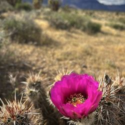
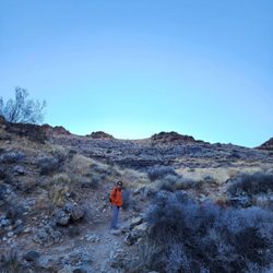
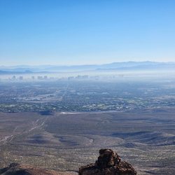
Willow Creek, at the northern end of the Spring Mountains in the boundaries of the Humboldt-Toiyabe National Forest, is a fun time! To get here you'll need to drive north on U.S. 95 from Las Vegas and then turn west off the 95 onto Cold Creek Road, which runs in between two prison facilities. It's about 17 miles of paved road until you see the sign for Willow Creek in your right. Once you turn, you will be on a dirt road and please remember to drive slow as there are residential homes along the road and animals. You will pass some picnic tables along the way that are great for a picnic or rest break. It's not very maintained out here, because the creek has washed out roadways and the proper authorizes stopped maintaining the road, so you will find people at times camping, but not often. Most of the time it's dirt bikes, ATV's and 4x4 high-clearance vehicles stopping for lunch after riding the rugged road past Willow Creek. The amount of water in Willow Creek (about 3 miles from cold creek road where you turned for WC) depends on how much runoff from rain and snow fills it. The Nevada Spring Snail can be found in the creek, but please let them be and don't add anything to the water. Habitat loss effects the snails. Cottonwoods, willows, wildflowers and many beautiful shrubs thrive along the creek where wildlife likes to hang out. I heard lots of critters scurrying around in the bushes. You'll need to bring plenty of water and as always you'll need to pack out what you pack in. Nobody wants a trashy area and since this area isn't maintained as much it would be great if we who use it could just keep it nice. If you decide to drive through the creek and proceed further you will need at least a 4x4 high-clearance vehicle to safely make it through. Past the creek it's extremely rugged and will take you through Wheeler Pass into Pahrump. It's about 28 miles from Cold Creek all the way through to Pahrump. There are many other side roads and even one that will take you to Indian Springs. It's so so so important that you know where you are going before taking Wheeler Pass all the way through and have a map for sure. It can get confusing not knowing which road you should take and some are better for trucks/jeeps than others. Dirt bikes and ATVs are the best option for Wheeler Pass. Many have and will attempt to make it all the way through only to have to turn around because their vehicle simple cannot make it or they get stuck and need help. Oh yeah, cel signal pretty much doesn't happen out here past the creek. If you make it far enough you'll be lucky enough to take in the Tecopa Charcoal Ovens. It's a really fun ride when done right! read more


More info about Willow Creek
2875 Golden Willow Ln
Las Vegas, NV 89124
South Summerlin
Directions
Hours
Outdoor Amenities
You might also consider


Willow Creek - mountainbiking - Updated June 2026
Best of Las Vegas
People found Willow Creek by searching for…
Trending Searches in Las Vegas, NV
Bounce House Rentals near Willow Creek
Dog Friendly Things To Do near Willow Creek
Golf Cart Rentals near Willow Creek
Hiking Spots near Willow Creek
Jet Ski Rental near Willow Creek
Movie Theatre near Willow Creek
Nurseries & Gardening near Willow Creek
Outdoor Activities near Willow Creek
Pick Your Own Farms near Willow Creek
Picnic Areas near Willow Creek
River Swimming near Willow Creek
Strawberry Picking near Willow Creek
Summer Camps near Willow Creek
Swimming Holes near Willow Creek
Swimming Pools near Willow Creek
Browse Articles
Browse Nearby
BEST of Las Vegas, Nevada Coffee near Willow Creek
BEST of Las Vegas, Nevada Restaurants near Willow Creek
BEST of Las Vegas, Nevada Things to Do near Willow Creek
BEST of Las Vegas, Nevada Parks near Willow Creek
BEST of Las Vegas, Nevada Breakfast near Willow Creek
BEST of Las Vegas, Nevada Hiking Trails near Willow Creek
BEST of Las Vegas, Nevada Campgrounds near Willow Creek
Browse Brands
Related Searches in Las Vegas, NV
Affordable Bike Repair Services in Las Vegas, Nevada
Affordable Bike Tune Up Services in Las Vegas, Nevada
Affordable Kayak Rental Services in Las Vegas, Nevada
Affordable Mobile Bike Repair in Las Vegas, Nevada
Affordable Road Bike Rental in Las Vegas, Nevada
Best Electric Bike Rental Services in Las Vegas, Nevada
Best Fishing Locations and Guides in Las Vegas, Nevada
Best Nature Trails for Hiking in Las Vegas, Nevada
Best Places for Horseback Riding in Las Vegas, Nevada
Best Used Bikes for Sale Near Las Vegas, Nevada
Check Out Off Road Trails in Las Vegas, Nevada
Discover Dog Friendly Trails to Explore in Las Vegas, Nevada
Discover Popular Bike Tours in Las Vegas, Nevada
Discover Scenic Bike Paths in Las Vegas, Nevada
Discover Scenic Mountain Bike Trails Near Las Vegas, Nevada
Discover Top Nature Parks to Visit in Las Vegas, Nevada
Discover the Best Night Hike Trails in Las Vegas, Nevada
Dog-Friendly Hikes With Dogs in Las Vegas, Nevada
Enjoy Biking Adventures Around Las Vegas, Nevada
Enjoy Hiking Adventures in Las Vegas, Nevada
Enjoy a Beautiful Waterfall Hike in Las Vegas, Nevada
Enjoy the Best Tubing Experiences in Las Vegas, Nevada
Enjoy the Best Walking Trails in Las Vegas, Nevada
Explore BMX Bike Shops Near Las Vegas, Nevada
Explore Beautiful Parks and Green Spaces in Las Vegas, Nevada
Explore Bike Rentals Throughout Las Vegas, Nevada
Explore Easy Hikes Perfect for All in Las Vegas, Nevada
Explore Electric Bikes Available in Las Vegas, Nevada
Explore Popular Scenic Overlook Points in Las Vegas, Nevada
Explore Scenic Lakes to Visit in Las Vegas, Nevada
Explore Secret Spots Worth Visiting in Las Vegas, Nevada
Explore the Best Beach Spots in Las Vegas, Nevada
Explore the Best Trail Options in Las Vegas, Nevada
Family Friendly Hiking With Kids in Las Vegas, Nevada
Find Cheap Bike Rentals Around Las Vegas, Nevada
Find Top Mountain Bike Rental Options in Las Vegas, Nevada
Find Top-Rated Waterfalls in Las Vegas, Nevada Now
Find a Fixed Gear Bike Shop in Las Vegas, Nevada
Find the Best Bikes Available in Las Vegas, Nevada
Find the Best Scenic View Locations in Las Vegas, Nevada
Hiking Trails With Waterfalls in Las Vegas, Nevada
Off Leash Dog Hiking Trails in Las Vegas, Nevada
Plan a Scenic Drive Route Near Las Vegas, Nevada
Shop for Mountain Bikes at Local Stores in Las Vegas, Nevada
Top Hiking Trails to Explore in Las Vegas, Nevada
Top Running Trails to Explore in Las Vegas, Nevada
Top-Rated Camping Sites in Las Vegas, Nevada
Trusted Electric Bike Repair in Las Vegas, Nevada
People who viewed Willow Creek also viewed
Tule Springs Loop
5 reviews
Centennial
Bears Best Mountain Bike Trail
2 reviews
South Summerlin
Buckskin Cliff Shadows Trailhead
9 reviews
Northwest
Trail Canyon Trail
12 reviews
Western Beltway Trail North
14 reviews
Summerlin
Fletcher Canyon
34 reviews
Western Beltway Trail
12 reviews
New Oak Creek Trail
1 review
The Trails Park and Pool
20 reviews
Summerlin
Skye Canyon Park
14 reviews
Centennial