Blodgett Peak Photos


You might also consider
More like Blodgett Peak
Recommended Reviews - Blodgett Peak
Start your review...

Reviews With Photos

.")
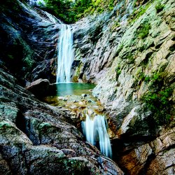
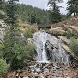
I absolutely loved doing this hike TODAY. The heavy rains have completely transformed the little creek and waterfalls. Instead of the rivulet of water we usually see, there is now a roaring creek and two full size respectful waterfalls that can be proud to be called such. It is very very sad once you get towards the top. It is a scene of desolation and despair. You can truly see the extent of the damage of Waldo Canyon fire on our mountains and hills. Atop Blodgett you get a 360 degree view of all the fire area as well as gorgeous views of the Air Force Academy, Black Forest, Colorado Springs and as far as your eye can see really. Oddly enough we get cell phone coverage all the way to the top. LOL. I disagree with the previous reviews stating that this is an easy hike or that it is good for children. THIS HIKE IS NOT FOR THE FAINT OF HEART. The terrain is treacherous at times and the trail is NOT marked. At times there is no trail at all, and you hike on your hands and knees. It is approximately a 4.7 miles climb from the parking area to the top of Blodgett...and the same if you want to get back to your car ;-) So expect this hike to take most of your day (unless you are a very experienced hiker). Only go with EXPERIENCED hikers who know how to get to the top or you will end up a casualty of the mountain as it happened only a month ago :-((( If one wants to only hike half way up the mountain, that is a fairly easy hike and one can bring kids. But NOT for the entire ascent to the peak. Too dangerous. Rock is loose and gravel is aplenty. Be careful out there!

Applying a review rating is problematic because so much depends on the hiker's conditioning and experience rather than the hike per se. Perhaps this is a trail runner's delight. Not being a trail runner, I can't say. The Blodgett Trailhead is easy to find and there is plenty of parking along Woodman Road once the trailhead parking is full, which is normal. From the trailhead, the trail starts on old asphalt and gravel road that bypasses a water tank. There are also community trails that traverse the front range in this section suited for casual chatty hiking with dogs and kids. I would go no higher if casual hiking is your interest. After leaving the wide broad road like sections of Blodgett Peak Trail, the climb upward becomes seriously strenuous through a maze of gravel, brush, and cactus lined social trails. As I discovered on the descent, I suggest hanging left as soon as possible and going up the left side of the intermittent stream until reaching the 'falls' that may or may not be running depending on the time of year. From here, there is no alternative but to cross the creek and begin traversing right through gravel chutes heading toward the saddle on the left side of the summit. This is very tedious hiking because of the ball bearing nature of the steep gravel surface that is often times mingled with stripped bare dirt. Rocks, scrub oak, and cactus adds to the hazards. It is easy to lose your footing, especially coming down. I opted to climb through the boulder field on the right side of the valley up higher. I did so to relieve the tedium of picking my way through the maze of steep gravel chutes and an inbred desire to explore the unknown. There were cairns through the predominately red rocks of the boulder field marking a route that lead to a chute that exited near the top of the Easterly false summit of Blodgett. This is a definite rock scrambling route but more interesting than slogging up gravel chutes, in my opinion. This route adds significant distance and time to the climb as the bushy ridge that leads to the actual Blodgett summit remains. I climbed Blodgett Peak once before, about 15 years ago. I doubt that I'll do it again.

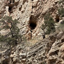
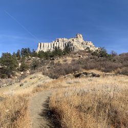
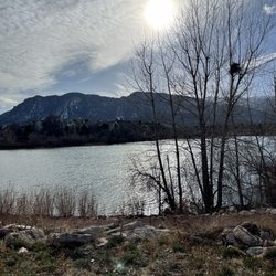
Looking for a decent hike in the Colorado Springs area aside from Pike's Peak or the Incline? Look no further... Blodgett Peak is closer to the Springs than both of those, and it's a relatively short hike (when compared to hiking Pikes Peak or any 14'er for the matter). The total altitude gain is about 2,000-2,500' and is about 4-5 miles round trip. The views from the top are actually quite nice and gives a much better perspective of the Springs, specifically all the neighborhoods that are literally at the base of the Front Range. Also offers a view looking North at the Academy and is close enough so that you can just make out people walking about there. The trail isn't extraordinarily well marked, but just aim up and you'll summit without a problem. There are areas of loose gravel/dirt which make getting down slightly more difficult but nothing hard. In short: A really nice hike close to home. Also, bonus fact: On the backside of the mountain, mid-way is an airplane that crashed in the 50's. The wreckage is still there if you feel like exploring

2 months ago


3 years ago
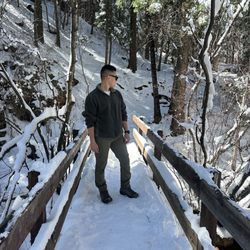
Trail Series, Part 15 Ex*hil*a*ra*tion: uncontrolled feelings of euphoria or elation. I'm sure there's many ways to arrive at this destination. One of them is running, and running in the snow just takes things to a whole new level for me. With that in mind, imagine my exhilaration when a Review Team Member suggested we seize the opportunity to run in a snow storm today! Blodgett Open Space can be found on West Woodmen Road (just North of Orchard Valley Road) in Colorado Springs, Colorado. When we arrived it was snowing, 11 degrees, and it would have taken an legion to wipe the smile off my face! Rejoining our Review Team for this adventure was Jasper "The Mountain Dog", so our confidence for survival was high. On several portions of our adventure we enjoyed making "first tracks" in the snow and we basically felt like we had the mountain to ourselves. We reached a peak elevation of 7,500 feet and discovered that your phone will actually turn itself off as a defense mechanism when it gets too cold. While our experience was euphoric, we are sadden to report that not all of our Review Team Members returned safely to Base Camp with us (not true, and yes Jasper is fine. Check the pics and you'll understand. ). There are multiple trails to explore, so you can tailor your adventure to just how much glee you are prepared for. While not required for this journey, I found the use of snow micro spikes quite useful (they can be a fitted over your running shoes). And that's...Henry's Take. #snowrunning #blogettopenspace #coloradosprings Trail Series, Part 15 Ex*hil*a*ra*tion: uncontrolled feelings of euphoria or elation. I'm sure there's many ways to arrive at this destination. One of them is running, and running in the snow just takes things to a whole new level for me. With that in mind, imagine my exhilaration when a Review Team Member suggested we seize the opportunity to run in a snow storm today! Blodgett Open Space can be found on West Woodmen Road (just North of Orchard Valley Road) in Colorado Springs, Colorado. When we arrived it was snowing, 11 degrees, and it would have taken an legion to wipe the smile off my face! Rejoining our Review Team for this adventure was Jasper "The Mountain Dog", so our confidence for survival was high. On several portions of our adventure we enjoyed making "first tracks" in the snow and we basically felt like we had the mountain to ourselves. We reached a peak elevation of 7,500 feet and discovered that your phone will actually turn itself off as a defense mechanism when it gets too cold. While our experience was euphoric, we are sadden to report that not all of our Review Team Members returned safely to Base Camp with us (not true, and yes Jasper is fine. Check the pics and you'll understand. ). There are multiple trails to explore, so you can tailor your adventure to just how much glee you are prepared for. While not required for this journey, I found the use of snow micro spikes quite useful (they can be a fitted over your running shoes). And that's...Henry's Take. #snowrunning #blogettopenspace #coloradosprings read more


4 years ago
8 years ago
Great hike. Challenging and 3/4 of the way it's easy to become off trail as approaching the last portion of the hike. Rated Hard on AllTrails Give it a try, you'll see! read more


I absolutely loved doing this hike TODAY. The heavy rains have completely transformed the little creek and waterfalls. Instead of the rivulet of water we usually see, there is now a roaring creek and two full size respectful waterfalls that can be proud to be called such. It is very very sad once you get towards the top. It is a scene of desolation and despair. You can truly see the extent of the damage of Waldo Canyon fire on our mountains and hills. Atop Blodgett you get a 360 degree view of all the fire area as well as gorgeous views of the Air Force Academy, Black Forest, Colorado Springs and as far as your eye can see really. Oddly enough we get cell phone coverage all the way to the top. LOL. I disagree with the previous reviews stating that this is an easy hike or that it is good for children. THIS HIKE IS NOT FOR THE FAINT OF HEART. The terrain is treacherous at times and the trail is NOT marked. At times there is no trail at all, and you hike on your hands and knees. It is approximately a 4.7 miles climb from the parking area to the top of Blodgett...and the same if you want to get back to your car ;-) So expect this hike to take most of your day (unless you are a very experienced hiker). Only go with EXPERIENCED hikers who know how to get to the top or you will end up a casualty of the mountain as it happened only a month ago :-((( If one wants to only hike half way up the mountain, that is a fairly easy hike and one can bring kids. But NOT for the entire ascent to the peak. Too dangerous. Rock is loose and gravel is aplenty. Be careful out there! read more
. - Hiking Near Me - Colorado Springs, Colorado")


10 years ago
Applying a review rating is problematic because so much depends on the hiker's conditioning and experience rather than the hike per se. Perhaps this is a trail runner's delight. Not being a trail runner, I can't say. The Blodgett Trailhead is easy to find and there is plenty of parking along Woodman Road once the trailhead parking is full, which is normal. From the trailhead, the trail starts on old asphalt and gravel road that bypasses a water tank. There are also community trails that traverse the front range in this section suited for casual chatty hiking with dogs and kids. I would go no higher if casual hiking is your interest. After leaving the wide broad road like sections of Blodgett Peak Trail, the climb upward becomes seriously strenuous through a maze of gravel, brush, and cactus lined social trails. As I discovered on the descent, I suggest hanging left as soon as possible and going up the left side of the intermittent stream until reaching the 'falls' that may or may not be running depending on the time of year. From here, there is no alternative but to cross the creek and begin traversing right through gravel chutes heading toward the saddle on the left side of the summit. This is very tedious hiking because of the ball bearing nature of the steep gravel surface that is often times mingled with stripped bare dirt. Rocks, scrub oak, and cactus adds to the hazards. It is easy to lose your footing, especially coming down. I opted to climb through the boulder field on the right side of the valley up higher. I did so to relieve the tedium of picking my way through the maze of steep gravel chutes and an inbred desire to explore the unknown. There were cairns through the predominately red rocks of the boulder field marking a route that lead to a chute that exited near the top of the Easterly false summit of Blodgett. This is a definite rock scrambling route but more interesting than slogging up gravel chutes, in my opinion. This route adds significant distance and time to the climb as the bushy ridge that leads to the actual Blodgett summit remains. I climbed Blodgett Peak once before, about 15 years ago. I doubt that I'll do it again. read more


Looking for a decent hike in the Colorado Springs area aside from Pike's Peak or the Incline? Look no further... Blodgett Peak is closer to the Springs than both of those, and it's a relatively short hike (when compared to hiking Pikes Peak or any 14'er for the matter). The total altitude gain is about 2,000-2,500' and is about 4-5 miles round trip. The views from the top are actually quite nice and gives a much better perspective of the Springs, specifically all the neighborhoods that are literally at the base of the Front Range. Also offers a view looking North at the Academy and is close enough so that you can just make out people walking about there. The trail isn't extraordinarily well marked, but just aim up and you'll summit without a problem. There are areas of loose gravel/dirt which make getting down slightly more difficult but nothing hard. In short: A really nice hike close to home. Also, bonus fact: On the backside of the mountain, mid-way is an airplane that crashed in the 50's. The wreckage is still there if you feel like exploring read more


12 years ago
11 years ago
Absolutely amazing trails and great view from the top. The hike is steep on some patches but it's fairly easy that you can bring your kids or pets. The noise from the waterfall is relaxing as you go up. I would recommend if you want to go on a hike that's not too crowded and not too hard. read more

More info about Blodgett Peak
Blodgett Dr
Colorado Springs, CO 80919
Directions
Hours
Outdoor Amenities
Ask the Community - Blodgett Peak


Blodgett Peak - hiking - Updated June 2026
Best of Colorado Springs
People found Blodgett Peak by searching for…
Hiking Trails With Waterfalls in Colorado Springs, Colorado
Parks for Kids in Colorado Springs, Colorado
Parks in Colorado Springs, Colorado
Night View in Colorado Springs, Colorado
Waterfalls in Colorado Springs, Colorado
Playgrounds in Colorado Springs, Colorado
Walking Trails in Colorado Springs, Colorado
Campgrounds in Colorado Springs, Colorado
Parks With Shade in Colorado Springs, Colorado
Off Road Trails in Colorado Springs, Colorado
Things to Do in Colorado Springs, Colorado
Scenic View in Colorado Springs, Colorado
Running Trails in Colorado Springs, Colorado
Playgrounds for Kids in Colorado Springs, Colorado
Camping Sites in Colorado Springs, Colorado
Easy Hikes in Colorado Springs, Colorado
Hiking Groups in Colorado Springs, Colorado
Hiking With Kids in Colorado Springs, Colorado
Dog Friendly Trails in Colorado Springs, Colorado
Camping Cabins in Colorado Springs, Colorado
Stroller Friendly Hikes in Colorado Springs, Colorado
Canyoneering in Colorado Springs, Colorado
Trending Searches in Colorado Springs, CO
Black Owned Nail Salons near Blodgett Peak
Boat Rental near Blodgett Peak
Cliff Jumping near Blodgett Peak
Dog Friendly Trails near Blodgett Peak
Fishing Spots near Blodgett Peak
Kayak Rental near Blodgett Peak
Lakes & Ponds near Blodgett Peak
Off Road Trails near Blodgett Peak
Outdoor Activities near Blodgett Peak
Pick Your Own Farms near Blodgett Peak
Places To Walk Around near Blodgett Peak
Public Shower near Blodgett Peak
River Swimming near Blodgett Peak
River Tubing near Blodgett Peak
Rock Quarry near Blodgett Peak
Running Trails near Blodgett Peak
Scenic Night View near Blodgett Peak
Scenic Overlook near Blodgett Peak
Secluded Spots near Blodgett Peak
Soccer Store near Blodgett Peak
Strawberry Picking near Blodgett Peak
Sunrise View near Blodgett Peak
Swimming Holes near Blodgett Peak
Swimming Lakes near Blodgett Peak
Browse Articles
Browse Nearby
BEST of Colorado Springs, Colorado Coffee near Blodgett Peak
BEST of Colorado Springs, Colorado Restaurants near Blodgett Peak
BEST of Colorado Springs, Colorado Things to Do near Blodgett Peak
BEST of Colorado Springs, Colorado Parks near Blodgett Peak
BEST of Colorado Springs, Colorado Breakfast near Blodgett Peak
BEST of Colorado Springs, Colorado Fishing near Blodgett Peak
Browse Brands
Related Searches in Colorado Springs, CO
Affordable Kayak Rental Services in Colorado Springs, Colorado
Best Fishing Locations and Guides in Colorado Springs, Colorado
Best Places for Horseback Riding in Colorado Springs, Colorado
Check Out Off Road Trails in Colorado Springs, Colorado
Discover Dog Friendly Trails to Explore in Colorado Springs, Colorado
Discover Scenic Waterfall Spots in Colorado Springs, Colorado
Discover a Hiking Trail in Colorado Springs, Colorado
Discover the Best Night Hike Trails in Colorado Springs, Colorado
Dog-Friendly Hikes With Dogs in Colorado Springs, Colorado
Enjoy Camping Adventures Around Colorado Springs, Colorado
Enjoy Exciting Mountain Biking Adventures in Colorado Springs, Colorado
Enjoy Kayaking Adventures in Colorado Springs, Colorado
Enjoy Tent Camping Spots Around Colorado Springs, Colorado
Enjoy Water Activities and Fun in Colorado Springs, Colorado
Enjoy the Best Walking Trails in Colorado Springs, Colorado
Exciting Cliff Jumping Spots in Colorado Springs, Colorado
Experience Thrilling White Water Rafting in Colorado Springs, Colorado
Explore Beautiful Parks and Green Spaces in Colorado Springs, Colorado
Explore Bike Rentals Throughout Colorado Springs, Colorado
Explore Easy Hikes Perfect for All in Colorado Springs, Colorado
Explore Fun Activities to Do in Colorado Springs, Colorado
Explore Popular Campgrounds Near Colorado Springs, Colorado
Explore Popular Scenic Overlook Points in Colorado Springs, Colorado
Explore Scenic Lakes to Visit in Colorado Springs, Colorado
Explore Top Dog Parks in Colorado Springs, Colorado Near You
Explore the Best Beach Spots in Colorado Springs, Colorado
Explore the Best Boating Spots in Colorado Springs, Colorado
Explore the Best Swimming Holes Around Colorado Springs, Colorado
Explore the Scenic River in Colorado Springs, Colorado
Family Friendly Hiking With Kids in Colorado Springs, Colorado
Find Cozy Camping Cabins in Colorado Springs, Colorado
Find Parks and Recreation Activities in Colorado Springs, Colorado
Find Popular Ziplining Spots Around Colorado Springs, Colorado
Find the Best Parks for Picnics in Colorado Springs, Colorado
Find the Best Playgrounds to Visit in Colorado Springs, Colorado
Find the Best Scenic View Locations in Colorado Springs, Colorado
Hiking Trails With Waterfalls in Colorado Springs, Colorado
Off Leash Dog Hiking Trails in Colorado Springs, Colorado
Plan a Scenic Drive Route Near Colorado Springs, Colorado
Popular Outdoor Activities to Try in Colorado Springs, Colorado
Popular Picnic Spots to Visit in Colorado Springs, Colorado
Safe River Swimming Areas in Colorado Springs, Colorado
Safe and Fun Parks for Kids in Colorado Springs, Colorado
Top Climbing Spots and Gyms in Colorado Springs, Colorado
Top Places for Snorkeling in Colorado Springs, Colorado
Top Running Trails to Explore in Colorado Springs, Colorado
Top Swimming Lakes to Enjoy in Colorado Springs, Colorado
Top Swimming Spots and Pools in Colorado Springs, Colorado
Top Things to Do With Kids in Colorado Springs, Colorado
Walk Dog Friendly Hiking Trails in Colorado Springs, Colorado
People who viewed Blodgett Peak also viewed
Heizer Trail
2 reviews
Stanley Canyon Trail
6 reviews
High Chaparral Open Space
5 reviews
Monument rock
6 reviews
Williams Canyon Trail
3 reviews
Pancake Rocks Trail
4 reviews
Spruce Mountain Open Space - Douglas County
14 reviews
Rock Island Trail
4 reviews
Anne-Marie Falls Hiking Trail
1 review
Fox Run Regional Park
8 reviews