Blue Mountain Trail Photos


You might also consider
More like Blue Mountain Trail
Recommended Reviews - Blue Mountain Trail
Start your review...

Reviews With Photos

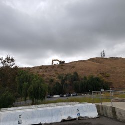
The most complicated issue with this trail is that a lot of people have trouble finding it. Since I'm a local I grew up doing this trail so thankfully I don't have an issue. It's a little hidden and most people miss it because it's in a residential area. Besides having a hard time finding it, it's a decent hike. Most of it is uphill which is really nice if your trying to get in a good workout for your lower body. The scenery is really nice and the view up top is beautiful as well especially if you go during the evening. It's a nice view of grand terrace. The other negative factor is if you go during the summer once in a while there is a lot of wind storms. If you have asthma like me try and avoid it. There is a lot of dirt and I've gone before during this time and it was so difficult to breathe even with an inhaler.

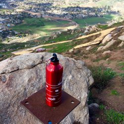
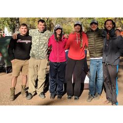
Went early morning this past Saturday with a friend and the view at the top definitely made waking up early on a Saturday worth it! Like Jav mentioned, it's a quiet trail and definitely a great one to do with friends. The trail has it's moments of butt kicking steep inclines, which means when you're walking back down the mountain to be careful! Enjoy the view while you're hiking up, and keep a look out for the legend marker! Enjoy! Parking: Street parking at the end of Westwood St x Westwood Lane. Distance: 4.5 miles, give or take which route you take up the mountain. Time: Took me a little less than 2 hours, start early unless you like the sun beating down on you! Dogs allowed: Definitely! Brought along my pup, but keep on a leash since this place frequents mountain bikers/dirt bikes.


Park at Westwood Street past Honey Hill Drive. There's a yellow gate which leads you to the trail head. It was my 3rd time on this trial and I went with a group of friends on a Saturday afternoon around 3pm. It was sunny and windy for the most part. I forgot how tough the hike was going up. Took us about an hour to get to the very top, and for a second I thought I was getting really unfit since I gained quite a few pounds in the past year. We took the path right ahead which was pretty steep and soaked up the view at the top. Tbh, I like this hike more than Hulda Crooks since it's not too crowded and there's actually a top. I'd recommend anyone to check it out if your in the area. Only thing I didn't like was there was a lot of dog poop and probably horse poop around in the middle of the trial.

Ive always seen this mountain driving past the freeway and have always wanted to explore it. Pretty easy to find! Multiple routes you can take to get to the top. If you're looking for a quick workout, avoid the switchbacks and take the trail straight up from the willow tree. Its a good incline to the top and you will be sure to break a sweat.


9 years ago
This is a killer trail and i did not make it up to the top. There were definitely many people who made it, but not me..so i will be rating this trail advanced. There are multiple trails that lead you to different places and some require you to go through very steep, rocky, and thorny paths. When we were coming down the trail, i realized there was one big path that can be taken there. Becareful as some parts are steep! I slid down a hill and took my friend down with me! read more


9 years ago
Blue Mountain Trail is my new Fav hiking route. It's less crowded than Mt. Robidoux . This trail is steep, which means more nasal flares for me(which is good, to make me sweat). Beautiful wild flowers, and its just beautiful to be seating on the huge rock once your up there. Fresh air and beautiful sunset. To those who wanted to watch the sunset- make sure you have flash lights and walking stick. It could go dark quickly before you reach back to your car. The only reason i Give 4 stars because of snakes. I hate snakes. make sure you are not alone hiking going up, just to be safe. Otherwise- beautiful. read more


The most complicated issue with this trail is that a lot of people have trouble finding it. Since I'm a local I grew up doing this trail so thankfully I don't have an issue. It's a little hidden and most people miss it because it's in a residential area. Besides having a hard time finding it, it's a decent hike. Most of it is uphill which is really nice if your trying to get in a good workout for your lower body. The scenery is really nice and the view up top is beautiful as well especially if you go during the evening. It's a nice view of grand terrace. The other negative factor is if you go during the summer once in a while there is a lot of wind storms. If you have asthma like me try and avoid it. There is a lot of dirt and I've gone before during this time and it was so difficult to breathe even with an inhaler. read more

10 years ago
Went early morning this past Saturday with a friend and the view at the top definitely made waking up early on a Saturday worth it! Like Jav mentioned, it's a quiet trail and definitely a great one to do with friends. The trail has it's moments of butt kicking steep inclines, which means when you're walking back down the mountain to be careful! Enjoy the view while you're hiking up, and keep a look out for the legend marker! Enjoy! Parking: Street parking at the end of Westwood St x Westwood Lane. Distance: 4.5 miles, give or take which route you take up the mountain. Time: Took me a little less than 2 hours, start early unless you like the sun beating down on you! Dogs allowed: Definitely! Brought along my pup, but keep on a leash since this place frequents mountain bikers/dirt bikes. read more


5 years ago
5 years ago
5 years ago
6 years ago
8 years ago
One of the best around Riverside, Redlands, San Bernadimo Area. Some areas are steeper but it is worth the hike. read more


9 years ago
Nice trail, I hadn't hiked in years and didn't have any trouble getting to the top. Best part is that it's not a popular trail. read more

Park at Westwood Street past Honey Hill Drive. There's a yellow gate which leads you to the trail head. It was my 3rd time on this trial and I went with a group of friends on a Saturday afternoon around 3pm. It was sunny and windy for the most part. I forgot how tough the hike was going up. Took us about an hour to get to the very top, and for a second I thought I was getting really unfit since I gained quite a few pounds in the past year. We took the path right ahead which was pretty steep and soaked up the view at the top. Tbh, I like this hike more than Hulda Crooks since it's not too crowded and there's actually a top. I'd recommend anyone to check it out if your in the area. Only thing I didn't like was there was a lot of dog poop and probably horse poop around in the middle of the trial. read more


8 years ago
10 years ago
Ive always seen this mountain driving past the freeway and have always wanted to explore it. Pretty easy to find! Multiple routes you can take to get to the top. If you're looking for a quick workout, avoid the switchbacks and take the trail straight up from the willow tree. Its a good incline to the top and you will be sure to break a sweat. read more


10 years ago


10 years ago
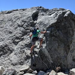
Like many of the surrounding hills, such as Jurupa, Blue Mountain is scattered with rocks everywhere and just seeing the different rock formations is worth the visit. My wife and I brought a friend along for a photo shoot and got some stunning shots. We were really happy with that and equally rewarded with the views from the top and joy of getting some good exercise. I returned later another time in the early morning and instead of going up the main trail kept walking straight up the backside. It has a really steep incline and what looks like a rock castle. As I approached the top I thought I saw a horse and realized it was a donkey. Then another and another followed after it and I was fortunate enough to see an entire herd of the wild feral donkeys. As I approached they all just stopped and were standing in a line with their ears raised up looking at my every move. We stared at each other for awhile and then I pushed onward to the top. Once there I turned on my GoPro and ran down the entire length of the switchbacks, google: "Running down Blue Mountain" and you can see the entire trail. This is perhaps one of my favorite trails now, best walked or run during the early morning or evening when the sun is not so strong. There isn't much shade. We brought along an umbrella. read more


10 years ago
9 years ago
10 years ago
8 years ago
9 years ago
More info about Blue Mountain Trail
Grand Terrace, CA 92313
Directions
Hours
Indoor Amenities
Outdoor Amenities
Ask the Community - Blue Mountain Trail
Is this hike dog friendly?
Where is the entrance for Blue Mountain Trail? Can you provide me the address close to the entrance? Thanks for your help!
So one of the entrances for the trail is adjacent to the intersection of Westwood Lane and Westwood St. in Grand Terrace.
Review Highlights - Blue Mountain Trail
You might also consider


Why does Yelp recommend reviews?
1 review that is not currently recommended
The reviews below are not factored into the business's overall star rating.
10 years ago
Blue Mountain Trail - hiking - Updated June 2026
Best of Grand Terrace
People found Blue Mountain Trail by searching for…
Things to Do in Grand Terrace, California
Hiking Trails in Grand Terrace, California
Beautiful Views in Grand Terrace, California
Scenic Views in Grand Terrace, California
Parks in Grand Terrace, California
Dirt Bike Riding in Grand Terrace, California
Walking Trails in Grand Terrace, California
Running Trails in Grand Terrace, California
Photo Spots in Grand Terrace, California
Sunset View in Grand Terrace, California
Dog Friendly Things to Do in Grand Terrace, California
Scenic Overlook in Grand Terrace, California
Watch Sunset in Grand Terrace, California
Secret Spots in Grand Terrace, California
Off Road Trails in Grand Terrace, California
Mountain Biking in Grand Terrace, California
Scenic Spots in Grand Terrace, California
Dog Friendly Hiking Trails in Grand Terrace, California
Parks for Kids in Grand Terrace, California
Romantic Views in Grand Terrace, California
Trails in Grand Terrace, California
Secluded Spots in Grand Terrace, California
Trending Searches in Grand Terrace, CA
Beaches near Blue Mountain Trail
Black Owned Nail Salons near Blue Mountain Trail
Boat Rental near Blue Mountain Trail
Cliff Jumping near Blue Mountain Trail
Creeks near Blue Mountain Trail
Day Trips near Blue Mountain Trail
Fishing Spots near Blue Mountain Trail
Free Kids Activities near Blue Mountain Trail
Jet Ski Rental near Blue Mountain Trail
Lakes & Ponds near Blue Mountain Trail
Off Road Trails near Blue Mountain Trail
Outdoor Activities near Blue Mountain Trail
Pick Your Own Farms near Blue Mountain Trail
Places To Walk Around near Blue Mountain Trail
Public Shower near Blue Mountain Trail
Rock Quarry near Blue Mountain Trail
Scenic Drive near Blue Mountain Trail
Scenic Night View near Blue Mountain Trail
Secluded Spots near Blue Mountain Trail
Soccer Store near Blue Mountain Trail
Splash Pad near Blue Mountain Trail
Strawberry Picking near Blue Mountain Trail
Sunrise View near Blue Mountain Trail
Swimming Holes near Blue Mountain Trail
Swimming Lakes near Blue Mountain Trail
Swimming Pools near Blue Mountain Trail
Watch Sunset near Blue Mountain Trail
Browse Articles
Browse Nearby
BEST of Grand Terrace, California Coffee near Blue Mountain Trail
BEST of Grand Terrace, California Restaurants near Blue Mountain Trail
BEST of Grand Terrace, California Things to Do near Blue Mountain Trail
BEST of Grand Terrace, California Breakfast near Blue Mountain Trail
BEST of Grand Terrace, California Walking Trails near Blue Mountain Trail
BEST of Grand Terrace, California Parks near Blue Mountain Trail
BEST of Grand Terrace, California Hot Springs near Blue Mountain Trail
BEST of Grand Terrace, California Campgrounds near Blue Mountain Trail
BEST of Grand Terrace, California Snow Tubing near Blue Mountain Trail
Browse Brands
Related Searches in Grand Terrace, CA
Best Fishing Locations and Guides in Grand Terrace, California
Best Nature Trails for Hiking in Grand Terrace, California
Best Places for Horseback Riding in Grand Terrace, California
Best Waterfalls and Swimming Holes in Grand Terrace, California
Check Out Off Road Trails in Grand Terrace, California
Discover Dog Friendly Trails to Explore in Grand Terrace, California
Discover Kid Friendly Hiking Trails in Grand Terrace, California
Discover Scenic Mountain Bike Trails Near Grand Terrace, California
Discover Scenic Waterfall Spots in Grand Terrace, California
Discover Top Nature Parks to Visit in Grand Terrace, California
Discover Top State Parks to Visit in Grand Terrace, California
Discover Walking Parks in Grand Terrace, California Near You
Discover a Hiking Trail in Grand Terrace, California
Discover the Best Night Hike Trails in Grand Terrace, California
Discover the Best Running Track in Grand Terrace, California
Dog-Friendly Hikes With Dogs in Grand Terrace, California
Enjoy Camping Adventures Around Grand Terrace, California
Enjoy Exciting Mountain Biking Adventures in Grand Terrace, California
Enjoy Kayaking Adventures in Grand Terrace, California
Enjoy Tent Camping Spots Around Grand Terrace, California
Enjoy a Beautiful Waterfall Hike in Grand Terrace, California
Enjoy the Best Picnic Spots and Ideas in Grand Terrace, California
Enjoy the Best Walking Path in Grand Terrace, California
Enjoy the Best Walking Trails in Grand Terrace, California
Exciting Cliff Jumping Spots in Grand Terrace, California
Explore Beautiful Parks and Green Spaces in Grand Terrace, California
Explore Easy Hikes Perfect for All in Grand Terrace, California
Explore Fun Activities to Do in Grand Terrace, California
Explore Popular Campgrounds Near Grand Terrace, California
Explore Top Dog Parks in Grand Terrace, California Near You
Explore the Best Swimming Holes Around Grand Terrace, California
Explore the Best Trail Options in Grand Terrace, California
Find Beautiful Views in Grand Terrace, California
Find Popular Ziplining Spots Around Grand Terrace, California
Find the Best Parks for Picnics in Grand Terrace, California
Great Places to Walk in Grand Terrace, California
Hike the Popular Waterfall Trail in Grand Terrace, California
Hiking Trails With Waterfalls in Grand Terrace, California
Off Leash Dog Hiking Trails in Grand Terrace, California
Plan a Scenic Drive Route Near Grand Terrace, California
Popular Fishing Spots to Explore in Grand Terrace, California
Popular Outdoor Activities to Try in Grand Terrace, California
Popular Picnic Spots to Visit in Grand Terrace, California
Safe River Swimming Areas in Grand Terrace, California
Safe and Fun Parks for Kids in Grand Terrace, California
Top Climbing Spots and Gyms in Grand Terrace, California
Top Running Trails to Explore in Grand Terrace, California
Top Swimming Lakes to Enjoy in Grand Terrace, California
Top Swimming Spots and Pools in Grand Terrace, California
Walk Dog Friendly Hiking Trails in Grand Terrace, California
People who viewed Blue Mountain Trail also viewed
Box Springs Two Trees Trail
38 reviews
Carriage Trail
2 reviews
San Gorgonio South Fork Trail
3 reviews
Big Falls
78 reviews
Blair Park
18 reviews
Box Springs Mountain Reserve
60 reviews
San Gorgonio Peak via Fish Creek
10 reviews
San Bernardino Peak
14 reviews
San Gorgonio 9 Peaks Challenge
2 reviews
Heart Rock
201 reviews