Boney Mountain Overlook Photos


You might also consider
More like Boney Mountain Overlook
Recommended Reviews - Boney Mountain Overlook
Start your review...

Reviews With Photos

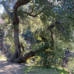
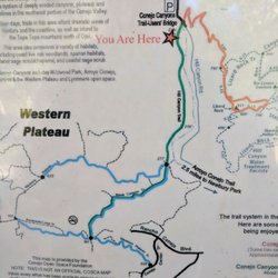
GETTIN' BONEY ON TRIPEAKS! STATS: Distance: 9-10 miles, 5-7 hours Elevation Gain: 2700 ft. Rating: Fairly strenuous Trail: Loop Another beeeautiful morning for a hike with The Crew. This route took us out to the Newbury Park area for a dirty, rocky, hands and knees adventure. Gloves were a much needed essential. This loop hike took us along some beautiful and isolated trails in the Boney Mountain State Wilderness Area of Point Mugu State Park to the spectacular rock formations of Tripeaks and then just a quarter mile further to the Boney Overlook. Crawlin' in some spots to Tripeaks, lunch was served. The view while we grubbed was such an added bonus. After lunch we headed down via the Upper Cabin Trail after a moment at Boney, past the old cabin site. The Western Ridge trail gets quite a bit of use, but is not officially maintained, so it is very narrow in places. Overall, it is quite steep, climbing 1200 feet in 1.2 miles, and it has some short and very steep sections. Long-sleeved shirts and long pants are strongly recommended to help protect against scratches aka Honor Badges from the chaparral. The views from the west and south are spectacularly stunning. Tripeaks is a hodgepodge of sandstone formations with huge boulders, caves and a groovy crevice to traverse. We could have spent hours exploring just this little area, but we will save that for another time. Boney offers sweeping views of Ventura County, Westlake, Malibu, Point Mugu State Park and the Pacific Ocean. On a clear day the Channel Islands are visible to the west. Despite its low elevation, Boney Peak rises dramatically from Sycamore Canyon near Camarillo. A good deal of its northern and western aspect is marked by a 1,500 foot precipice lined with jagged formations and rocky crags. DISCLAIMER: Hiking is not something that can be taken lightly. It can be life-threatening as you see and hear on the news, people die or get lost all time. Please, if you are going to hike, never go alone and prepare for the worst, hope for the best. Remember when going for a hike, no matter how short you think it may be, always be prepared. Carry at least two liters of water for every five miles (more if the weather is warm), protein bar, nuts, and electrolytes. Wear sturdy lug sole shoes and protective clothing. Some areas the weather can change quicker than a fireman can put on his gear. It is also very important, always always always let a family member or friend know where you are going and when you expect to be back. Lastly, have fun when you hike it up.

One of the toughest hikes I have ever done. Here are the stats: 7.5 roundtrip turn around trail 1600 elevation gain (tough gain though) The hike has spectacular views of mountains, Channel Islands, the valley, and the Pacific Ocean. The entire hike took our group about 5 hours with a 40 minute lunch break included in those 5 hours. It starts off nice and mellow, but getting closer to the peek there are some steep rocky portions. Dogs are not allowed on the last leg of the hike, passing the old fireplace I think. I did see people with dogs on the trail but I was told they would get a nice little ticket if they were caught by the ranger. This hike definitely made me want to purchase a walking stick. Enjoy!
")
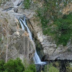
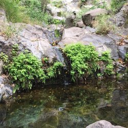
Here are some suggestions I wish I knew! 1. Avoid windy days! The old boney trail is all dirt road with lots of rocks :) 2. for the waterfall hike, you must make a left at the first fork you see! If you continue forward, it's the hike to Channel Islands. 3. Without any waterfall, the hike to the area is still quite gorgeous! 4. After hiking places in Orange County such as Crystal Cove, this hike is a lot of initial downward trails... Then toward the end is a lot of upward. It's not spread out with ups and downs like I'm used to. 5. If you want to see the "forest"y mountain area which is past the waterfall area, be sure to continue going all the way up past where you can see the ocean! Overall, quite a nice adventure :)


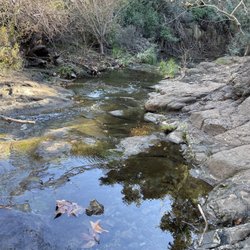
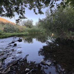
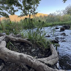
Date of the hike: 3.19.2011 According to my friend's GPS, we hiked 8.2 miles round trip with an elevation gain/loss of 2,000ft. We kind of just winged it and parked right at the end of Wendy Ave when you exit on the 101fwy. I think other websites out there say to park somewhere else. The hike itself had a couple signs here and there but we were still a little confused on which path to take. There's a nice waterfall about a mile into the hike and you'll have to cross a little stream. There's a lot of shade near the waterfall so it's a perfect area to rest or have a quick snack. I wish I read the description on LocalHikes.com (http://www.localhikes.com/Hikes/BoneyMountainOverlook_4472.asp) a little better. Instead of making a left towards Danielson Monument we took the other path which had a gradual incline, no switchbacks here. We did get to a different hill that has a good view and found the correct way to go to the overlook. If it wasn't for our time constraints, we would have back tracked and went up the right way. We'll have to go back and see the view from the top. http://www.flickr.com/photos/lamb1028/sets/72157626248248337/ read more


I don't really know how far this hike is. I'd say is around 8 or 9 miles. You're not really hiking when you go here. I see it more like as if you're climbing up a big rock. IT's nice. Pretty popular. And, sometimes you see horse poop on the trails. I'd say 1/4th of the way in, there's a beautiful waterfall you can hang out at. Walking up the trail, you're surrounded by big green mountains. At the top of Boney Mountain, there's a 360 view of the city. Really nice. It just takes awhile to get up there. It's not too bad though. Parking here is free. read more


6 years ago
Overall, nice long 7 mile hike. We went in Sept, so there was little to no water. We'll be back. read more


10 years ago
GETTIN' BONEY ON TRIPEAKS! STATS: Distance: 9-10 miles, 5-7 hours Elevation Gain: 2700 ft. Rating: Fairly strenuous Trail: Loop Another beeeautiful morning for a hike with The Crew. This route took us out to the Newbury Park area for a dirty, rocky, hands and knees adventure. Gloves were a much needed essential. This loop hike took us along some beautiful and isolated trails in the Boney Mountain State Wilderness Area of Point Mugu State Park to the spectacular rock formations of Tripeaks and then just a quarter mile further to the Boney Overlook. Crawlin' in some spots to Tripeaks, lunch was served. The view while we grubbed was such an added bonus. After lunch we headed down via the Upper Cabin Trail after a moment at Boney, past the old cabin site. The Western Ridge trail gets quite a bit of use, but is not officially maintained, so it is very narrow in places. Overall, it is quite steep, climbing 1200 feet in 1.2 miles, and it has some short and very steep sections. Long-sleeved shirts and long pants are strongly recommended to help protect against scratches aka Honor Badges from the chaparral. The views from the west and south are spectacularly stunning. Tripeaks is a hodgepodge of sandstone formations with huge boulders, caves and a groovy crevice to traverse. We could have spent hours exploring just this little area, but we will save that for another time. Boney offers sweeping views of Ventura County, Westlake, Malibu, Point Mugu State Park and the Pacific Ocean. On a clear day the Channel Islands are visible to the west. Despite its low elevation, Boney Peak rises dramatically from Sycamore Canyon near Camarillo. A good deal of its northern and western aspect is marked by a 1,500 foot precipice lined with jagged formations and rocky crags. DISCLAIMER: Hiking is not something that can be taken lightly. It can be life-threatening as you see and hear on the news, people die or get lost all time. Please, if you are going to hike, never go alone and prepare for the worst, hope for the best. Remember when going for a hike, no matter how short you think it may be, always be prepared. Carry at least two liters of water for every five miles (more if the weather is warm), protein bar, nuts, and electrolytes. Wear sturdy lug sole shoes and protective clothing. Some areas the weather can change quicker than a fireman can put on his gear. It is also very important, always always always let a family member or friend know where you are going and when you expect to be back. Lastly, have fun when you hike it up. read more


One of the toughest hikes I have ever done. Here are the stats: 7.5 roundtrip turn around trail 1600 elevation gain (tough gain though) The hike has spectacular views of mountains, Channel Islands, the valley, and the Pacific Ocean. The entire hike took our group about 5 hours with a 40 minute lunch break included in those 5 hours. It starts off nice and mellow, but getting closer to the peek there are some steep rocky portions. Dogs are not allowed on the last leg of the hike, passing the old fireplace I think. I did see people with dogs on the trail but I was told they would get a nice little ticket if they were caught by the ranger. This hike definitely made me want to purchase a walking stick. Enjoy! read more


5 years ago
6 years ago
12 years ago
Here are some suggestions I wish I knew! 1. Avoid windy days! The old boney trail is all dirt road with lots of rocks :) 2. for the waterfall hike, you must make a left at the first fork you see! If you continue forward, it's the hike to Channel Islands. 3. Without any waterfall, the hike to the area is still quite gorgeous! 4. After hiking places in Orange County such as Crystal Cove, this hike is a lot of initial downward trails... Then toward the end is a lot of upward. It's not spread out with ups and downs like I'm used to. 5. If you want to see the "forest"y mountain area which is past the waterfall area, be sure to continue going all the way up past where you can see the ocean! Overall, quite a nice adventure :) read more
 - Hiking Near Me - Newbury Park, California")

6 years ago
8 years ago
10 years ago
5 hour hike round trip, leave early during the summer to avoid the heat. If you're allergic to bees, so am I, there weren't that many when I went in March. read more


12 years ago
12 years ago
10 years ago
I've hiked this now two times. We park in the dirt parking lot off of Portrero and start the trail there. It took us four hours round trip and clocked 12.4 miles to the peak and back. Definitely do not do this hike on a warm day. It is fairly strenuous. The views at the top are glorious!! read more

15 years ago
13 years ago
11 years ago
More info about Boney Mountain Overlook
Ask the Community - Boney Mountain Overlook
Review Highlights - Boney Mountain Overlook
You might also consider


Boney Mountain Overlook - hiking - Updated July 2026
Best of Newbury Park
People found Boney Mountain Overlook by searching for…
Beaches in Newbury Park, California
Beautiful Views in Newbury Park, California
Photo Spots in Newbury Park, California
Scenic View in Newbury Park, California
Hiking Trails in Newbury Park, California
Places to Take Pictures in Newbury Park, California
Waterfall Hike in Newbury Park, California
Parks in Newbury Park, California
Off Road Trails in Newbury Park, California
Walking Trails in Newbury Park, California
Star Gazing in Newbury Park, California
Scenic Overlook in Newbury Park, California
Lakes & Ponds in Newbury Park, California
Running Trails in Newbury Park, California
Night Hike in Newbury Park, California
Free Things to Do in Newbury Park, California
Easy Hikes in Newbury Park, California
Hiking Groups in Newbury Park, California
Meteor Shower in Newbury Park, California
Natural Hot Springs in Newbury Park, California
Trail in Newbury Park, California
Abandoned Buildings in Newbury Park, California
Browse Nearby
BEST of Newbury Park, California Things to Do near Boney Mountain Overlook
BEST of Newbury Park, California Coffee near Boney Mountain Overlook
BEST of Newbury Park, California Restaurants near Boney Mountain Overlook
BEST of Newbury Park, California Parks near Boney Mountain Overlook
BEST of Newbury Park, California Breakfast near Boney Mountain Overlook
BEST of Newbury Park, California Beaches near Boney Mountain Overlook