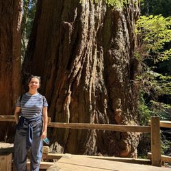
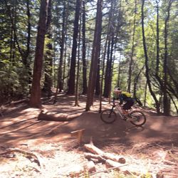
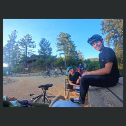
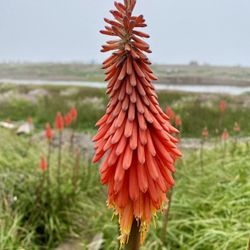
Coastal View Trail Photos


You might also consider
More like Coastal View Trail
Recommended Reviews - Coastal View Trail
Start your review...

The person who reviewed this 11 years ago was spot on about the beauty of this trail. He biked it, which was definitely a lot of climbing and I hiked it today. I'm surprised no one else has reviewed this beautiful trail. We chose this hike because it was so hot today inland-it turns out it was a good decision. The hike begins with climbing almost all the way to the of trail. However, there are sweeping views of the coast, Mount Tamalpais, and beyond. The most fascinating part was the abundance of sedimentary rock we were surrounded by- truly astounding. I had to look up the history of these rocks and learned this- we were looking at one of California's most famous geological features: radiolarian ribbon chert. The strata with the various colors was clearly visible & striking. Additionally we were impressed with the large concrete bunker complex (at the top of climb) Battery Townsley. It's the massive WWII gun battery perched above Fort Cronkhite and Rodeo Beach. I highly recommend this hike for those that enjoy spectacular, coastal views, history, and geology. read more

11 years ago
More info about Coastal View Trail
801 Panoramic Hwy
Mill Valley, CA 94941
Directions
Hours
Outdoor Amenities
You might also consider


Coastal View Trail - hiking - Updated July 2026
Best of Mill Valley
People found Coastal View Trail by searching for…
Mountain Bike Trails in Mill Valley, CA
Cliff Diving in Mill Valley, CA
Photo Spots in Mill Valley, CA
Scenic View in Mill Valley, CA
Walking Trails in Mill Valley, CA
View Points in Mill Valley, CA
Horseback Trail Rides in Mill Valley, CA
Swimming Lakes in Mill Valley, CA
Beach Hiking Trails in Mill Valley, CA
Dirt Bike Trails in Mill Valley, CA
Kids Friendly Beaches in Mill Valley, CA
Off Road Trails in Mill Valley, CA
Lookout Points in Mill Valley, CA
Things to Do With Kids in Mill Valley, CA
Shaded Hike in Mill Valley, CA
Bike Parking in Mill Valley, CA
Kid Friendly Hiking Trails in Mill Valley, CA
Romantic Spots in Mill Valley, CA
Trending Searches in Mill Valley, CA
Blueberry Picking near Coastal View Trail
Cliff Jumping near Coastal View Trail
Day Trips near Coastal View Trail
Dog Friendly Beaches near Coastal View Trail
Dog Friendly Trails near Coastal View Trail
Free Picnic Areas near Coastal View Trail
Hikes With Dogs near Coastal View Trail
Jet Ski Rental near Coastal View Trail
Kayak Rental near Coastal View Trail
Lookout Points near Coastal View Trail
Nature Trails near Coastal View Trail
Off Road Trails near Coastal View Trail
Outdoor Activities near Coastal View Trail
Peach Picking near Coastal View Trail
Picnic Spots near Coastal View Trail
Places To Swim near Coastal View Trail
Places To Walk Around near Coastal View Trail
Pool Day Pass near Coastal View Trail
Public Shower near Coastal View Trail
River Swimming near Coastal View Trail
River Tubing near Coastal View Trail
Rock Quarry near Coastal View Trail
Scenic Night View near Coastal View Trail
Scenic Overlook near Coastal View Trail
Secluded Spots near Coastal View Trail
Soccer Store near Coastal View Trail
Star Gazing near Coastal View Trail
Sunrise View near Coastal View Trail
Swimming Holes near Coastal View Trail
Swimming Lakes near Coastal View Trail
U Pick Farms near Coastal View Trail
Browse Nearby
BEST of Mill Valley, California Coffee near Coastal View Trail
BEST of Mill Valley, California Restaurants near Coastal View Trail
BEST of Mill Valley, California Things to Do near Coastal View Trail
BEST of Mill Valley, California Parks near Coastal View Trail
BEST of Mill Valley, California Breakfast near Coastal View Trail
BEST of Mill Valley, California Lakes near Coastal View Trail
BEST of Mill Valley, California Campgrounds near Coastal View Trail
BEST of Mill Valley, California Lodging near Coastal View Trail
Browse Brands
Related Searches in Mill Valley, CA
Affordable Bike Repair Services in Mill Valley, California
Affordable Bike Tune Up Services in Mill Valley, California
Affordable Cheap Bike Tune Up Services in Mill Valley, California
Affordable Kayak Rental Services in Mill Valley, California
Best Dirt Bike Riding Spots in Mill Valley, California
Best Dog Hiking Trails Around Mill Valley, California
Best Electric Bike Rental Services in Mill Valley, California
Best Fishing Locations and Guides in Mill Valley, California
Best Nature Trails for Hiking in Mill Valley, California
Best Places for Horseback Riding in Mill Valley, California
Best Sightseeing Experiences Available in Mill Valley, California
Check Out Off Road Trails in Mill Valley, California
Convenient Bike Sharing Programs in Mill Valley, California
Discover Dog Friendly Trails to Explore in Mill Valley, California
Discover Easy Hiking Trails Near Mill Valley, California
Discover Kid Friendly Hiking Trails in Mill Valley, California
Discover Popular Bike Tours in Mill Valley, California
Discover Popular Bike Trails in Mill Valley, California
Discover Scenic Bike Paths in Mill Valley, California
Discover Scenic Mountain Bike Trails Near Mill Valley, California
Discover a Hiking Trail in Mill Valley, California
Discover the Best Night Hike Trails in Mill Valley, California
Dog-Friendly Hikes With Dogs in Mill Valley, California
Enjoy Biking Adventures Around Mill Valley, California
Enjoy Camping Adventures Around Mill Valley, California
Enjoy Hiking Adventures in Mill Valley, California
Enjoy Kayaking Adventures in Mill Valley, California
Enjoy Off Leash Dog Hikes in Mill Valley, California
Enjoy Scenic Dirt Bike Trails Around Mill Valley, California
Enjoy Scenic Places to Walk in Mill Valley, California
Enjoy a Beautiful Waterfall Hike in Mill Valley, California
Enjoy the Best Walking Path in Mill Valley, California
Enjoy the Best Walking Trails in Mill Valley, California
Explore BMX Bike Shops Near Mill Valley, California
Explore Beautiful Parks and Green Spaces in Mill Valley, California
Explore Bike Rentals Throughout Mill Valley, California
Explore Cycling Stores in Mill Valley, California
Explore Easy Hikes Perfect for All in Mill Valley, California
Explore Electric Bikes Available in Mill Valley, California
Explore Fun Activities to Do in Mill Valley, California
Explore Popular Campgrounds Near Mill Valley, California
Explore Popular Dog Walking Trails in Mill Valley, California
Explore Popular Scenic Views Near Mill Valley, California
Explore Top Dog Parks in Mill Valley, California Near You
Explore the Best Beach Spots in Mill Valley, California
Explore the Best Rock Climbing Areas in Mill Valley, California
Explore the Best Swimming Holes Around Mill Valley, California