Heintz Open Space Photos


You might also consider
More like Heintz Open Space
Recommended Reviews - Heintz Open Space
Start your review...

Reviews With Photos

My daughter found this spot several years ago, when the developers built this community they included this hiking trail which was very smart. Our family has always called the place "Wilson's " because our first time there, a dog named Wilson was there and so cute. We go here often since not many people are not around like the other places in LG. One day we were just taking a different route than the usual and we found a bike park right in the middle, so cool for young boys. There was some junk that someone just threw there, I hate that !!

Good place to hike with your dog(s), the trails are pretty short, the Valley View trail is 1 mile one way, for their first .5 miles, the trails have a good incline. The Vista Trail is 0.3 miles one way The Skyline trail have a really good view of San Jose It is connected to Santa Rosa OSP, and you can do a longer hike to Belgato park Dog owner, remember to trash your doggie bags in the end!

4 months ago
Beautiful! Saw some deer, chipmunks, birds and butterflies. There were also quite a bit of yellow flowers. I need to go again! read more


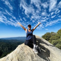
Whew! If you want a leg burning challenge, check out the hiking trails that end in Heintz Open Space Preserve. I like to start at Belgatos park, take the Santa Rosa Trail (.4 miles) to Valley View Trail (1 mile) to Vista Trail (.3 miles). It's rolling hills going up and a great work out. If you do them all as an out and back, it's a fantastic 3.4 mile hike. Vista Trail has the best view but generally the entire hike will show you stunning views of Los Gatos and San Jose. Dogs are welcome on leashes and you're sure to encounter a few furry friends. read more


5 years ago
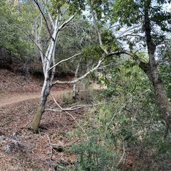
Just did this hike today with my sister. We parked in the beautiful neighborhood of Heritage Grove which side note - is really nice to walk around. The trailhead for the hike is right off the street, hard to miss, and there's a map outlining the different trails. The paths are wide which is great since we're practicing social distancing and wearing masks. There were other hikers on the trails and mountain bikers, and dogs are allowed on leash. The views are beautiful, open landscape views of the city, and gorgeous lush green hills. It's a great workout, sometimes it got steep but thankfully it wasn't too treacherous. There are a lot of forks in the trail so make sure you know where you're going! read more


8 years ago
My daughter found this spot several years ago, when the developers built this community they included this hiking trail which was very smart. Our family has always called the place "Wilson's " because our first time there, a dog named Wilson was there and so cute. We go here often since not many people are not around like the other places in LG. One day we were just taking a different route than the usual and we found a bike park right in the middle, so cool for young boys. There was some junk that someone just threw there, I hate that !! read more

8 years ago
Good place to hike with your dog(s), the trails are pretty short, the Valley View trail is 1 mile one way, for their first .5 miles, the trails have a good incline. The Vista Trail is 0.3 miles one way The Skyline trail have a really good view of San Jose It is connected to Santa Rosa OSP, and you can do a longer hike to Belgato park Dog owner, remember to trash your doggie bags in the end! read more

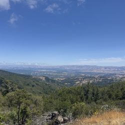
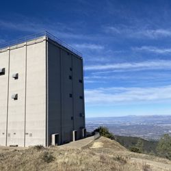
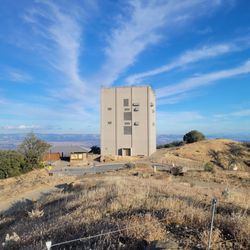
 Right: Vista Trail (0.3 Mile one way) - Hiking Near Me")


One of only two open spaces in Los Gatos, this convenient little nature sanctuary offers some short but somewhat elevated hikes without having to trek it up into the mtns. Having only done the Vista Trail hike so far, this 0.3 miler is a fantastic up n back to a scenic overview as the name implies...perfect for after work jaunt with a view! The Valley View Trail is longer and does connect to Santa Rose Open Space for those looking to keep on truckin. Street parking is fairly abundant and next to trail head. read more


9 years ago
8 years ago
11 years ago
18 years ago
11 years ago
12 years ago
More info about Heintz Open Space
Los Gatos, CA 95032
Directions
Visit Website
http://www.losgatosca.gov/index.asp?NID=1326
Hours
Indoor Amenities
Outdoor Amenities
Ask the Community - Heintz Open Space
Review Highlights - Heintz Open Space
You might also consider


Why does Yelp recommend reviews?
1 review that is not currently recommended
The reviews below are not factored into the business's overall star rating.
9 years ago
Heintz Open Space - hiking - Updated June 2026
Best of Los Gatos
People found Heintz Open Space by searching for…
Hiking Trails in Los Gatos, CA
Great View Points in Los Gatos, CA
Dog Friendly Parks in Los Gatos, CA
Dog Friendly Hiking Trails in Los Gatos, CA
Walking Trails in Los Gatos, CA
Dog Friendly Beaches in Los Gatos, CA
Scenic Drives in Los Gatos, CA
Scenic Places to Walk in Los Gatos, CA
Dog Friendly Things to Do in Los Gatos, CA
Hikes With Dogs in Los Gatos, CA
Walking Groups in Los Gatos, CA
Off Leash Dog Hikes in Los Gatos, CA
Stroller Friendly Hikes in Los Gatos, CA
Trending Searches in Los Gatos, CA
Beaches near Heintz Open Space
Black Owned Nail Salons near Heintz Open Space
Boat Rental near Heintz Open Space
Cliff Jumping near Heintz Open Space
Day Trips near Heintz Open Space
Dog Friendly Trails near Heintz Open Space
Fishing Spots near Heintz Open Space
Free Kids Activities near Heintz Open Space
Jet Ski Rental near Heintz Open Space
Lakes & Ponds near Heintz Open Space
Off Road Trails near Heintz Open Space
Outdoor Activities near Heintz Open Space
Pick Your Own Farms near Heintz Open Space
Public Shower near Heintz Open Space
Rock Quarry near Heintz Open Space
Scenic Drive near Heintz Open Space
Scenic Night View near Heintz Open Space
Secluded Spots near Heintz Open Space
Soccer Store near Heintz Open Space
Splash Pad near Heintz Open Space
Strawberry Picking near Heintz Open Space
Sunrise View near Heintz Open Space
Swimming Holes near Heintz Open Space
Swimming Lakes near Heintz Open Space
Swimming Pools near Heintz Open Space
Watch Sunset near Heintz Open Space
Browse Articles
Browse Nearby
BEST of Los Gatos, California Restaurants near Heintz Open Space
BEST of Los Gatos, California Coffee near Heintz Open Space
BEST of Los Gatos, California Things to Do near Heintz Open Space
BEST of Los Gatos, California Walking Trails near Heintz Open Space
BEST of Los Gatos, California Parks near Heintz Open Space
BEST of Los Gatos, California Breakfast near Heintz Open Space
BEST of Los Gatos, California Campgrounds near Heintz Open Space
BEST of Los Gatos, California Caves near Heintz Open Space
BEST of Los Gatos, California Hot Springs near Heintz Open Space
Browse Brands
Related Searches in Los Gatos, CA
Affordable Kayak Rental Services in Los Gatos, California
Best Fishing Locations and Guides in Los Gatos, California
Best Nature Trails for Hiking in Los Gatos, California
Best Places for Horseback Riding in Los Gatos, California
Best Waterfalls and Swimming Holes in Los Gatos, California
Check Out Off Road Trails in Los Gatos, California
Discover Dog Friendly Trails to Explore in Los Gatos, California
Discover Kid Friendly Hiking Trails in Los Gatos, California
Discover Scenic Hiking Trails in Los Gatos, California
Discover Scenic Mountain Bike Trails Near Los Gatos, California
Discover Scenic Waterfall Spots in Los Gatos, California
Discover Walking Parks in Los Gatos, California Near You
Discover a Hiking Trail in Los Gatos, California
Discover the Best Night Hike Trails in Los Gatos, California
Dog-Friendly Hikes With Dogs in Los Gatos, California
Enjoy Camping Adventures Around Los Gatos, California
Enjoy Exciting Mountain Biking Adventures in Los Gatos, California
Enjoy Kayaking Adventures in Los Gatos, California
Enjoy Tent Camping Spots Around Los Gatos, California
Enjoy a Beautiful Waterfall Hike in Los Gatos, California
Enjoy a Peaceful Nature Walk in Los Gatos, California
Enjoy the Best Walking Path in Los Gatos, California
Enjoy the Best Walking Trails in Los Gatos, California
Exciting Cliff Jumping Spots in Los Gatos, California
Experience Thrilling White Water Rafting in Los Gatos, California
Explore Beautiful Parks and Green Spaces in Los Gatos, California
Explore Easy Hikes Perfect for All in Los Gatos, California
Explore Fun Activities to Do in Los Gatos, California
Explore Popular Campgrounds Near Los Gatos, California
Explore the Best Beach Spots in Los Gatos, California
Explore the Best Trail Options in Los Gatos, California
Family Friendly Hiking With Kids in Los Gatos, California
Find Popular Ziplining Spots Around Los Gatos, California
Find the Best Parks for Picnics in Los Gatos, California
Find the Best Scenic View Locations in Los Gatos, California
Great Places to Walk in Los Gatos, California
Hike the Popular Waterfall Trail in Los Gatos, California
Hiking Trails With Waterfalls in Los Gatos, California
Off Leash Dog Hiking Trails in Los Gatos, California
Plan a Scenic Drive Route Near Los Gatos, California
Popular Outdoor Activities to Try in Los Gatos, California
Popular Picnic Spots to Visit in Los Gatos, California
Safe River Swimming Areas in Los Gatos, California
Safe and Fun Parks for Kids in Los Gatos, California
Top Climbing Spots and Gyms in Los Gatos, California
Top Paddleboarding Activities in Los Gatos, California
Top Running Trails to Explore in Los Gatos, California
Top Swimming Spots and Pools in Los Gatos, California
People who viewed Heintz Open Space also viewed
St Joseph's Hill Open Space Preserve
61 reviews
Novitiate Park
6 reviews
Bear Creek Redwoods Preserve
32 reviews
Hunter's Point
36 reviews
Villa Montalvo
47 reviews
Almaden Quicksilver County Park
296 reviews
Los Alamitos Creek Trail
44 reviews
El Sereno Open Space Preserve
5 reviews
Lexington Reservoir County Park
63 reviews
Overlook Trail
1 review