
Hunter's Point Photos


You might also consider


More like Hunter's Point
Recommended Reviews - Hunter's Point
Start your review...


Reviews With Photos


Nice easy hike with kids. Parking lot is tiny but we were lucky on Friday to find a spot. We saw 3 deers an a butterfly landed on my husband. Nice open space with some hills.


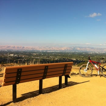
An easy 0.6-mile roundtrip hike suitable for any age. I came here on an early Sunday morning with my boyfriend's family and we all enjoyed the quick hike. It's a bit steep at times, but overall very doable and you get to enjoy the green scenery, blooming trees, and views of South Bay. At the top, there's a large bench you could sit at, enjoy a snack, and take some photos. Be aware of cyclists! There are many people biking the paths here, so be wary of that as you're walking the trail.


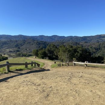
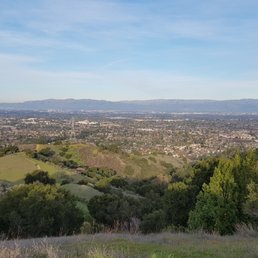
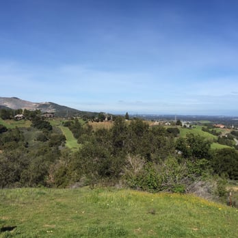
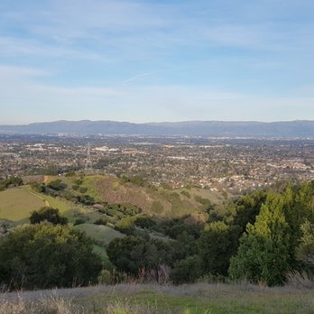
On a clear day, Hunter's Point offers a panoramic view of Silicon Valley, with stunning vistas of some of the cities within it, including Mountain View, Cupertino, and West San Jose. If the air is particularly crisp, you can even see Shoreline Amphitheatre and the hangers at Moffett Field. Hunter's Point is within Fremont Older Open Space Preserve, which contains a myrid of intertwined trails, so there are short, medium, and long hikes that will bring you to Hunter's Point. The short route is a simple out and back which runs 1.2 miles one way. It's straight up the Hayfield Trail from the parking lot off Prospect Road. Tip: The downside of Hunter's Point being inside Fremont Older is the inadequate parking. The lot is so small and cramped that it can be challenging coming here even during the week; on weekends it's a complete and total cluster f**k. Many times I've had to park out on the main road and hike twenty minutes just to get to parking lot so I could "start" hiking. The medium hike is a 4 mile loop which includes the Seven Springs Trail. This trail has enough changing elevation and terrain variation to be an enjoyable and moderately challenging hike, but its tame enough so that Spenser the Wonder Dog (who had tiny legs but a huge heart) could make it most of the way under his own power. The long hike that includes Hunter's Point is 8 or 9 miles, and a fairly rigorous challenge. It's done starting from the Hayfield Trail, then incorporating the Seven Springs Trail, passing through Hunter's Point, and then down Hayfield Trail and up another loop which includes the Coyote Ridge Trail, and the Vista Loop Trail to round back past the back end of the Cooper-Garrod Estate Vineyards, then around in front of the Garrod Farms Stables and back down the trail there to return to the Hayfield Trail and end up back at the parking lot. My personal favorite of the hikes outlined above is the long one, but whichever hike you find most appealing will yield a great view and a good, dog-friendly hike.


A beautiful place to see the sunrise. I was going to drive out to the Lick Observatory pre-dawn, but it takes over an hour to get there from Mountain View. So I looked for some place local. Hunter's Point is not as nice as Lick, but it has some nice trails above SCV. And the sunrise was pretty nice, too.


Having lived in Cupertino for over 30 years and hiked all the trails around, Hunter's Point is definitely one of the best in the South Bay Area. I made an aerial video with a GoPro mounted on my rc helicopter for a birds eye view of the area: http://www.youtube.com/watch?v=7edJJIgbhkY


I have been to Hunter's Point over 100 times but this is my first review about the peak. My favorite spot to check-in into Yelp and get network coverage to check my email/text while doing mountain biking. This is not the highest peak at Fremont Older, there are 2 other peaks which I highly recommend - Masei's Peak and Nob Hill. But Hunter's Point is the most popular peak you see after the first climb and easy uphill hike for kids and family. The Open Space Preserve recently replaced with a new bench for resting and this is great place to make conversation with strangers while catching your breath.


This hiking spot features nice long hills with upward ascension in most of the way. Be warned though, unlike some other hiking spots, this one in particular has less shade and resting areas. So during summer time, this hiking spot can get quite hot. Nonetheless, it is a very nice hike. Many riders with horses would come up this trail, so you would have an opportunity to see that as well. This point is named Hunter's Point because there is a high spot with the same name that oversees the entire mountain terrain, which is very nice view for a great photo! There is 0 bathroom opportunities on this trail. I still prefer some other trails that have a bit more of basic necessary amenities. But overall, this is a good hike to try!

9 months ago

First time hiking this trail. Heard about it via friend. The entrance we used was tucked in behind a residential area. Once we walked through the gates you see the steep slopes you are about to engage, there is no gradual beginning. Put your big kid undies on and get er done. Once you get up the initial incline, the trail is pretty consistent. There are a few more hurdles, nothing too difficult. However, it was quite muddy due to the recent rain. That added a minor level of difficulty with attempting not to fall. Beautiful views of snow capped Mount Hamilton... there are different trails to choose from. Nonetheless all views are breath taking. I will definitely go back. read more


3 years ago


6 years ago

An easy 0.6-mile roundtrip hike suitable for any age. I came here on an early Sunday morning with my boyfriend's family and we all enjoyed the quick hike. It's a bit steep at times, but overall very doable and you get to enjoy the green scenery, blooming trees, and views of South Bay. At the top, there's a large bench you could sit at, enjoy a snack, and take some photos. Be aware of cyclists! There are many people biking the paths here, so be wary of that as you're walking the trail. read more


9 years ago
On a clear day, Hunter's Point offers a panoramic view of Silicon Valley, with stunning vistas of some of the cities within it, including Mountain View, Cupertino, and West San Jose. If the air is particularly crisp, you can even see Shoreline Amphitheatre and the hangers at Moffett Field. Hunter's Point is within Fremont Older Open Space Preserve, which contains a myrid of intertwined trails, so there are short, medium, and long hikes that will bring you to Hunter's Point. The short route is a simple out and back which runs 1.2 miles one way. It's straight up the Hayfield Trail from the parking lot off Prospect Road. Tip: The downside of Hunter's Point being inside Fremont Older is the inadequate parking. The lot is so small and cramped that it can be challenging coming here even during the week; on weekends it's a complete and total cluster f**k. Many times I've had to park out on the main road and hike twenty minutes just to get to parking lot so I could "start" hiking. The medium hike is a 4 mile loop which includes the Seven Springs Trail. This trail has enough changing elevation and terrain variation to be an enjoyable and moderately challenging hike, but its tame enough so that Spenser the Wonder Dog (who had tiny legs but a huge heart) could make it most of the way under his own power. The long hike that includes Hunter's Point is 8 or 9 miles, and a fairly rigorous challenge. It's done starting from the Hayfield Trail, then incorporating the Seven Springs Trail, passing through Hunter's Point, and then down Hayfield Trail and up another loop which includes the Coyote Ridge Trail, and the Vista Loop Trail to round back past the back end of the Cooper-Garrod Estate Vineyards, then around in front of the Garrod Farms Stables and back down the trail there to return to the Hayfield Trail and end up back at the parking lot. My personal favorite of the hikes outlined above is the long one, but whichever hike you find most appealing will yield a great view and a good, dog-friendly hike. read more


9 years ago


5 years ago
Great place to see the sunrise! The peak is only half a mile from the entrance. Starting at the entrance on Regnart Road in Cupertino, you can probably get to the peak within 15 to 30 minutes. read more


7 years ago
A beautiful place to see the sunrise. I was going to drive out to the Lick Observatory pre-dawn, but it takes over an hour to get there from Mountain View. So I looked for some place local. Hunter's Point is not as nice as Lick, but it has some nice trails above SCV. And the sunrise was pretty nice, too. read more


13 years ago
Having lived in Cupertino for over 30 years and hiked all the trails around, Hunter's Point is definitely one of the best in the South Bay Area. I made an aerial video with a GoPro mounted on my rc helicopter for a birds eye view of the area: http://www.youtube.com/watch?v=7edJJIgbhkY read more


I have been to Hunter's Point over 100 times but this is my first review about the peak. My favorite spot to check-in into Yelp and get network coverage to check my email/text while doing mountain biking. This is not the highest peak at Fremont Older, there are 2 other peaks which I highly recommend - Masei's Peak and Nob Hill. But Hunter's Point is the most popular peak you see after the first climb and easy uphill hike for kids and family. The Open Space Preserve recently replaced with a new bench for resting and this is great place to make conversation with strangers while catching your breath. read more




This hiking spot features nice long hills with upward ascension in most of the way. Be warned though, unlike some other hiking spots, this one in particular has less shade and resting areas. So during summer time, this hiking spot can get quite hot. Nonetheless, it is a very nice hike. Many riders with horses would come up this trail, so you would have an opportunity to see that as well. This point is named Hunter's Point because there is a high spot with the same name that oversees the entire mountain terrain, which is very nice view for a great photo! There is 0 bathroom opportunities on this trail. I still prefer some other trails that have a bit more of basic necessary amenities. But overall, this is a good hike to try! read more



7 years ago
5 years ago

10 years ago

10 years ago
Nice hike with some shade. Parking is difficult during the holidays. The view at Hunter's point towards the valley is great, in certain days you can even see San Francisco! read more
5 years ago


7 years ago

13 years ago


12 years ago


12 years ago


10 years ago

13 years ago

11 years ago


12 years ago
More info about Hunter's Point
Woodhills Trl
Saratoga, CA 95070
Directions
Hours
Outdoor Amenities
Ask the Community - Hunter's Point
Review Highlights - Hunter's Point
You might also consider

















Why does Yelp recommend reviews?

Hunter's Point - hiking - Updated September 2026
Best of Saratoga
People found Hunter's Point by searching for…
Trending Searches in Saratoga, CA
Apple Orchards near Hunter's Point
Apple Picking near Hunter's Point
Bird Sanctuary near Hunter's Point
Cliff Jumping near Hunter's Point
Consignment Shops near Hunter's Point
Cruising Spots near Hunter's Point
Dog Friendly Things To Do near Hunter's Point
Ear Piercing near Hunter's Point
Eyebrow Threading near Hunter's Point
Flower Fields near Hunter's Point
Hair Braiding near Hunter's Point
Kids Haircut near Hunter's Point
Mens Haircut near Hunter's Point
Picnic Areas near Hunter's Point
Preschools near Hunter's Point
Public Golf Courses near Hunter's Point
Rock Quarry near Hunter's Point
Running Trails near Hunter's Point
Scenic Night View near Hunter's Point
Scenic Overlook near Hunter's Point
Sunrise View near Hunter's Point
Swimming Holes near Hunter's Point
Trading Card Shops near Hunter's Point
Browse Articles
Browse Nearby
BEST of Saratoga, California Coffee near Hunter's Point
BEST of Saratoga, California Restaurants near Hunter's Point
BEST of Saratoga, California Things to Do near Hunter's Point
BEST of Saratoga, California Walking Trails near Hunter's Point
BEST of Saratoga, California Parks near Hunter's Point
BEST of Saratoga, California Breakfast near Hunter's Point
BEST of Saratoga, California Campgrounds near Hunter's Point
Browse Brands
Related Searches in Saratoga, CA
Affordable Kayak Rental Services in Saratoga, California
Best Dog Hiking Trails Around Saratoga, California
Best Fishing Locations and Guides in Saratoga, California
Best Nature Trails for Hiking in Saratoga, California
Best Places for Horseback Riding in Saratoga, California
Best Sightseeing Experiences Available in Saratoga, California
Check Out Off Road Trails in Saratoga, California
Discover Dog Friendly Trails to Explore in Saratoga, California
Discover Easy Hiking Trails Near Saratoga, California
Discover Kid Friendly Hiking Trails in Saratoga, California
Discover Popular Bike Trails in Saratoga, California
Discover Walking Parks in Saratoga, California Near You
Discover a Hiking Trail in Saratoga, California
Discover the Best Night Hike Trails in Saratoga, California
Dog-Friendly Hikes With Dogs in Saratoga, California
Enjoy Camping Adventures Around Saratoga, California
Enjoy Kayaking Adventures in Saratoga, California
Enjoy Off Leash Dog Hikes in Saratoga, California
Enjoy Scenic Places to Walk in Saratoga, California
Enjoy Tent Camping Spots Around Saratoga, California
Enjoy a Beautiful Waterfall Hike in Saratoga, California
Enjoy the Best Walking Path in Saratoga, California
Enjoy the Best Walking Trails in Saratoga, California
Explore Beautiful Parks and Green Spaces in Saratoga, California
Explore Easy Hikes Perfect for All in Saratoga, California
Explore Fun Activities to Do in Saratoga, California
Explore Popular Campgrounds Near Saratoga, California
Explore Popular Dog Walking Trails in Saratoga, California
Explore Top Dog Parks in Saratoga, California Near You
Explore the Best Beach Spots in Saratoga, California
Family Friendly Hiking With Kids in Saratoga, California
Find Parks and Recreation Activities in Saratoga, California
Find Top Dog Friendly Parks to Visit in Saratoga, California
Find Top-Rated Waterfalls in Saratoga, California Now
Find the Best Parks for Picnics in Saratoga, California
Hiking Trails With Waterfalls in Saratoga, California
Off Leash Dog Hiking Trails in Saratoga, California
Popular Outdoor Activities to Try in Saratoga, California
Popular Picnic Spots to Visit in Saratoga, California
Popular Waterfall Hiking Trails in Saratoga, California
Safe River Swimming Areas in Saratoga, California
Safe and Fun Parks for Kids in Saratoga, California
Top Hiking Trails to Explore in Saratoga, California
Top Playgrounds for Kids to Enjoy in Saratoga, California
Top Running Trails to Explore in Saratoga, California
Top Swimming Lakes to Enjoy in Saratoga, California
Top Swimming Spots and Pools in Saratoga, California
Top-Rated Camping Sites in Saratoga, California


