Jockey Cap Trail Photos


You might also consider
More like Jockey Cap Trail
Recommended Reviews - Jockey Cap Trail
Start your review...

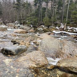
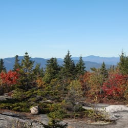
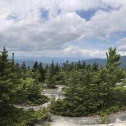
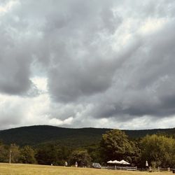
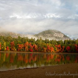
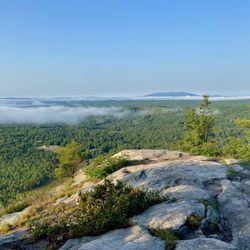
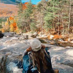
To me, a perfect trail is one that: not a lot of people know about, is hidden in plain sight, has some challenging parts (it's good to feel the heart pumping! ... but my legs don't need to quiver in fatigue with every step; does that make sense?), and offers an impressive reward by way of view at the top. Jockey Cap Trail is all of that. A former ski hill in the 30's (it boasts of having had the first rope tow in Maine), Jockey Cap is now a trail system (unfortunately, many of the off-branches of the two main routes up lead to dead-ends). Tucked right behind a country store off Route 302 in Fryeburg, you'll find a dirt trail that first leads into the woods to Molly Locket's cave. Here's your Robert Frost moment: from here, the trail splits to the left and right. The former offers a gradual climb, the latter is much more steep. Regardless of which you choose, both are only about a quarter mile long. At the top are breathtaking views of forest, lakes, valleys, and mountain ranges. There's also a bronze silhouette allowing climbers to line up which mountain is which. It's a short climb, but if you're in the area, it's worth it - especially in spring and autumn when the colors are on opposite ends of the spectrum of impressive and the tourists are at a minimum. I would say it's kid-friendly if your kids are active and love the outdoors; as a side note, while brief in length, I would still say this leads more towards "hike" then "nature walk". read more


5 years ago
Fun short hike with nice views at the top. Not enough parking. Trail not well marked but you can figure it out. Use all trails. read more


More info about Jockey Cap Trail
16 Bridgton Rd
Fryeburg, ME 04037
Directions
Hours
Outdoor Amenities


Jockey Cap Trail - hiking - Updated June 2026
Best of Fryeburg
People found Jockey Cap Trail by searching for…
Things to Do in Fryeburg, Maine
Hiking Trails in Fryeburg, Maine
Beautiful Views in Fryeburg, Maine
Scenic View in Fryeburg, Maine
Secret Spots in Fryeburg, Maine
Walking Trails in Fryeburg, Maine
Tourist Attractions in Fryeburg, Maine
Lakes & Ponds in Fryeburg, Maine
Swimming Holes in Fryeburg, Maine
Off Leash Dog Hikes in Fryeburg, Maine
Watch Sunset in Fryeburg, Maine
Running Trails in Fryeburg, Maine
Fun Things to Do With Kids in Fryeburg, Maine
Attractions in Fryeburg, Maine
Dog Friendly Trails in Fryeburg, Maine
Hiking Trails Kid Friendly in Fryeburg, Maine
Trending Searches in Fryeburg, ME
Boat Rental near Jockey Cap Trail
Cliff Jumping near Jockey Cap Trail
Dog Friendly Beaches near Jockey Cap Trail
Dog Friendly Things To Do near Jockey Cap Trail
Fishing Spots near Jockey Cap Trail
Jet Ski Rental near Jockey Cap Trail
Kayak Rental near Jockey Cap Trail
Lakes & Ponds near Jockey Cap Trail
Outdoor Activities near Jockey Cap Trail
Peach Picking near Jockey Cap Trail
Pick Your Own Farms near Jockey Cap Trail
Pool Supplies near Jockey Cap Trail
Public Shower near Jockey Cap Trail
River Swimming near Jockey Cap Trail
River Tubing near Jockey Cap Trail
Scenic Night View near Jockey Cap Trail
Scenic Overlook near Jockey Cap Trail
Splash Pad near Jockey Cap Trail
Strawberry Picking near Jockey Cap Trail
Swimming Holes near Jockey Cap Trail
Watch Sunset near Jockey Cap Trail
Browse Articles
Browse Nearby
BEST of Fryeburg, Maine Things to Do near Jockey Cap Trail
BEST of Fryeburg, Maine Restaurants near Jockey Cap Trail
BEST of Fryeburg, Maine Coffee near Jockey Cap Trail
BEST of Fryeburg, Maine Campgrounds near Jockey Cap Trail
BEST of Fryeburg, Maine Swimming Holes near Jockey Cap Trail
BEST of Fryeburg, Maine Photo Spots near Jockey Cap Trail
BEST of Fryeburg, Maine Ski Resorts near Jockey Cap Trail
Browse Brands
Related Searches in Fryeburg, ME
Affordable Jet Ski Rental Options in Fryeburg, Maine
Affordable Kayak Rental Services in Fryeburg, Maine
Best Fishing Locations and Guides in Fryeburg, Maine
Best Fun Things to Do in Fryeburg, Maine
Best Places for Horseback Riding in Fryeburg, Maine
Best Sledding Spots and Fun in Fryeburg, Maine
Best Waterfalls and Swimming Holes in Fryeburg, Maine
Discover Dog Friendly Trails to Explore in Fryeburg, Maine
Discover Lakes & Ponds to Explore in Fryeburg, Maine
Discover Popular Photo Spots in Fryeburg, Maine
Discover a Hiking Trail in Fryeburg, Maine
Discover the Best Night Hike Trails in Fryeburg, Maine
Dog-Friendly Hikes With Dogs in Fryeburg, Maine
Enjoy Camping Adventures Around Fryeburg, Maine
Enjoy Exciting Mountain Biking Adventures in Fryeburg, Maine
Enjoy River Tubing Adventures in Fryeburg, Maine
Enjoy the Best Tubing Experiences in Fryeburg, Maine
Enjoy the Best Walking Trails in Fryeburg, Maine
Exciting Cliff Jumping Spots in Fryeburg, Maine
Experience Thrilling White Water Rafting in Fryeburg, Maine
Explore Beautiful Parks and Green Spaces in Fryeburg, Maine
Explore Bike Rentals Throughout Fryeburg, Maine
Explore Easy Hikes Perfect for All in Fryeburg, Maine
Explore Family-Friendly Zoos and Wildlife in Fryeburg, Maine
Explore Fun Activities to Do in Fryeburg, Maine
Explore Popular Campgrounds Near Fryeburg, Maine
Explore Popular RV Parks Around Fryeburg, Maine
Explore Scenic Lakes to Visit in Fryeburg, Maine
Explore Top Dog Parks in Fryeburg, Maine Near You
Explore the Best Boating Spots in Fryeburg, Maine
Explore the Best Swimming Holes Around Fryeburg, Maine
Family Friendly Hiking With Kids in Fryeburg, Maine
Find Beautiful Views in Fryeburg, Maine
Find Cozy Camping Cabins in Fryeburg, Maine
Find Popular Ziplining Spots Around Fryeburg, Maine
Find Top-Rated Disc Golf in Fryeburg, Maine
Find the Best Parks BBQ Grills in Fryeburg, Maine
Find the Best Playgrounds to Visit in Fryeburg, Maine
Find the Best Scenic View Locations in Fryeburg, Maine
Find the Best Swimming Pools in Fryeburg, Maine Today
Hiking Trails With Waterfalls in Fryeburg, Maine
Off Leash Dog Hiking Trails in Fryeburg, Maine
Perfect Spots to Watch Sunset in Fryeburg, Maine
Popular Kids Activities in Fryeburg, Maine
Popular Things to Do in Fryeburg, Maine
Top Fishing Charter Experiences in Fryeburg, Maine
Top Paddleboarding Activities in Fryeburg, Maine
Top Running Trails to Explore in Fryeburg, Maine