Cancel

    Open app

    Search

    Lake Sawyer Park Foundation

    5.0 (1 review)

    Lake Sawyer Park Foundation Photos
    You might also consider

    More like Lake Sawyer Park Foundation

    Recommended Reviews - Lake Sawyer Park Foundation

    Your trust is our priority, so businesses can't pay to alter or remove their reviews. Learn more about reviews.
    Yelp app icon
    Browse more easily on the app
    Review Feed Illustration

    1 year ago

    Helpful 5
    Thanks 2
    Love this 4
    Oh no 0

    You might also consider

    Verify this business for free

    People searched for Parks 3,616 times last month within 15 miles of this business.

    Verify this business

    Franklin Ghost Town

    Franklin Ghost Town

    3.6
    (13 reviews)
    4.2 mi

    We were told about this trail by a local who walked through the Ghost Town several years ago. This…read moresounded like a fun adventure so we took a hike. First: the parking area is chained shut and 'tow' signs are in the drive way area that leads to the parking lot. We drove over a one-way bridge (traffic signals control traffic direction) and found a parking area on the right. This area also has the same 'tow' signs but the lot had several vehicles and many people were in the area so we parked. It's a shady lot with a spring water dispenser straight from the ground. (A sign asks that you Venmo money for any water you take from the Spring) We walked back over the bridge, past the gate and onto the trail. Second: the initial hike is a wide incline covered in gravel. This leads you up and around to a Coal Car where the trail divides. The Ghost Town is to your right. The mine shaft and grave yard are to your left. Both trails continue to lead up. One of the hike pages I looked over described this as an 'easy' trail for kids. Regarding climbing over obstacles, the path is clear and it is an easy hike if you go toward the ghost town. However, the grade is pretty steep in that direction. The direction of the mine however has several trees down and most we had to climb over. The trail there is not well maintained. The Ghost Town: This pathway is mostly wide and gravel covered making it the easier of the two trails. We found one foundation covered in undergrowth on the right that you can climb the steps onto a small foundation. You have to really be looking to see the steps. On the left is what looks almost like a retaining wall on the hillside. That's all we saw of a 'town'. The path continues to climb up and around. It may lead out to the road on the opposite side of the hill but we did not walk all the way and I make that suggestion based on maps. This trail is mostly full sun. The Mine Shaft and Graveyard: We came back and took the left branch of the trail where it divides at the Coal Car. This trail runs from wide and gravel covered to single file while walking through raspberry bushes (prickers). Thankfully we had rain jackets on so those tiny thorns did not snag our shirts and I kept my hands above my head to save my skin. Be prepared for that. This trail is mostly shady. It takes a while to reach the mine shaft which includes a plaque with some mine information. The shaft is quite large, goes straight down, is surrounded by a metal railing and topped with a lattice of rebar. The sign suggest you drop a rock in to hear how deep the shaft is, however as this must have been done hundreds of times, rocks nearby are scarce. Bring your own rock with you. Once you have spent all the time you'd like at the mine shaft, take the trail to the left of the mine shaft plaque to continue on to the graveyard. There are a couple of places along the way that will make you wonder 'is this it?' It's not. Just keep going. It's another longish hike in a more gentle upward direction. The path veers off to your right at several points, one of which leads to a wet low area, but overhead here you will see remnants of some coal car rails. There is a trail leading up a steep incline that will take you to the top of the rails if you'd like a closer look. The 'up' is easier than the 'down' on this steep pathway. The graveyard is further ahead, past this coal car rail. Just keep walking. You will see on your right, at the base of a tree, a toppled over headstone that looks like a small obelisk. This, and a wooden sign erected by a local group stating they fenced in a grave, are the main visible signs of the graveyard. The area is completely overgrown, including the fenced in grave. After climbing over trees and fending off thorny raspberry bushes (without the joy of eating some of the berries) this was a disappointing hike. The trail ends here. Some of the downed trees have had a path chopped or cut out so you can walk around or through them but most your scramble over. I am not sure what is happening with this land or why the lot is closed with no explanation sign. I could not find information in a search of local news sites. I do wonder however if it has anything to do with a downtrodden looking 'resort' on the other side of the bridge. They offer you access to a waterfall for a small fee. I believe you can access this waterfall from the chained lot if you take the trail directly down to the river on the left. But this is just speculation. I did not take them up on their offer. If you are here for a nice, uphill hike, take the path to the right at the coal car and enjoy a wider path with some views of the surrounding area. That is a pleasant hike in and of itself. Just don't expect to see a 'ghost town' and you'll enjoy this hike. Happy hiking!

    While the hike in and out was nice, easy for kids (of at least aged 5 years), and relatively quick,…read morethe ghost town wasn't really worth the effort (destination).

    Photos
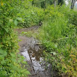
    Path is wet in places - seems to come from a spring along side the path way.
    Path is wet in places - seems to come from a spring along side the path way.
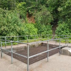
    Mine shaft is covered in a grate and fenced for your safety.
    Mine shaft is covered in a grate and fenced for your safety.
    Trail toward the cemetery is very narrow in spots with thorny plants along the way. Just fyi.

    See all

    Trail toward the cemetery is very narrow in spots with thorny plants along the way. Just fyi.
    Lake Wilderness

    Lake Wilderness

    4.0
    (31 reviews)
    3.7 mi

    Decided to go Trout Fishing on Friday (5/16/25) afternoon around 2:00 PM. When we got to the Lake,…read morethere were 4 people at the fishing spot. We set up our gear and poles. It was kind of a gloomy day, so fish weren't biting as often. About 2 hours later, we had caught 3 Trouts each. Getting the next 2 took a while longer, as I caught mine an hour and a half later to get my limit of 5. Dunno what factors caused the fish not to bite that regularly, but it was definitely a very slow day/evening fishing on the shore. Caught a couple of big ones, though. Nice sized fish...

    I've been to Lake Wilderness many times over the years for family get togethers, and a graduation…read moreparty brought me here again yesterday! The space here is huge and there's lots to see and do. There's an area with a playground for kids which is camp themed, and there's also different types of sport courts. The bathrooms are clean and well-maintained as well. There's also covered areas that you can rent which have basic grills that you can use for stuff like hotdogs and burgers. The water always seems pretty clean. I haven't swam in it but my siblings and kids have and it always seems fine. They also have boat rentals here which are really cool, and there's a few different types that you can rent. It's a little over $20 an hour but I think it's worth it for sure. It's a great lake and I'm sure we'll be back quite a few times this summer!

    Photos
    Lake Wilderness
    Lake Wilderness
    Lake Wilderness

    See all

    Lake Sawyer Park Foundation - parks - Updated July 2026

    Loading...
    Loading...
    Loading...