Maxwell Mays Wildlife Refuge Photos


You might also consider
More like Maxwell Mays Wildlife Refuge
Recommended Reviews - Maxwell Mays Wildlife Refuge
Start your review...

Reviews With Photos


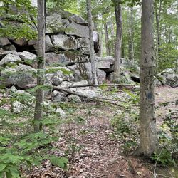
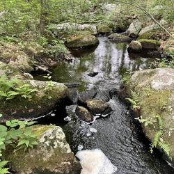
Accessible and easy hike on well-marked trails, with some nice water views, old field stone walls, and impressive glacial boulders. There are two trails - Carr Pond (white blaze) and Hammitt Hill (yellow) - but both (ca. 3 miles cumulative) can be done in a leisurely 1.5 hours or so. There are a couple of steep climbs near the Hammitt Hill portion, but not too bad, and enough for a change of pace. The trails are mostly woodland but you do follow the shoreline of Carr Pond which is very pretty and peaceful. Hiking the trails at this time of year was very pleasant as the weather was cooler, not buggy, gorgeous leaf colors, and more light and visibility as there were fewer leaves. A couple of neat "finds" along the trail: An historic cemetery, remains of a farmhouse basement and fireplace, and some truly massive glacial boulders! N.B. There are no restrooms or porta-potties at the parking lot/trailhead, so you will have to make like a bear if needed!

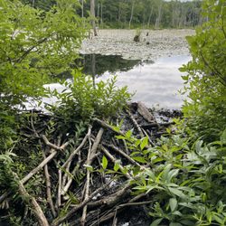
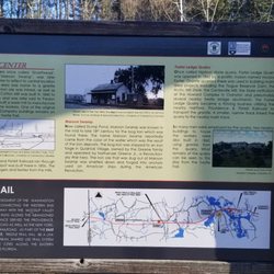
I would like this land to breathe Maxwell Mays was one of Rhode lsland's best known folk artists and for decades he was in great demand not only for his wonderful and historic Rhode Island art but also for his speaking and storyteller abilities. Maxwell was also a philanthropist and environmentalist and when he died at the age of 91 donated his land to the Audubon Society so future generations could enjoy it. The roughly 300 acre refuge actually started as a farm way back in the early 18th century and the area continued as a working farm with large herds of cattle and sheep until Mays finally bought the property in 1941. Maxwell May lived and loved the property until his death in 2009. The area was dedicated this year as the Maxwell Mays Wildlife Refuge is and is now part of the Audubon Society. The refuge is a quite place with mature forest and wetlands. The roughly 11 acre Carr Pond is in the middle and at the right time of the year lots of birds, amphibians, reptiles, fish and even beaver and otter can be seen. The hiking is easy with few hills or rocks and all the trails are very well marked. A nice place to hike for people that aren't deep wood wise or just want a simple walk in the forest. The present trial is only about a mile and a half long but by next spring another trial up Hammitt Hill will open that will make the hiking a bit more interesting. This isn't a place for a strenuous workout, it's a pleasant and quiet area that should be taken slowly to fully appreciate the beautiful scenery and subtle wildness. It will be great for snowshoeing and cross-country skiing in the winter because of the lack of nasty hills and dangerous ledges. Certainly not the place to go if you want some exciting and lung burning hiking, there are plenty of other hikes nearby that will give you that. This is a peaceful place to see some wildlife, hear and smell nature and take part in some quiet contemplation. Maxwell stated that he wanted this land to breathe and stay open because it has been very good to him. His gift will ensure that the old farm will continue to be good to others.

With a break in the weather we wanted to get out and enjoy some fresh air. We pulled up our 'AllTrails' app and decided to explore this hiking/walking path. This refuge is clearly marked by a decent sized sign from the road so you shouldn't miss it. There is also plenty of parking but no facilities. At the beginning of the path, the rules are clearly displayed and you can grab a map. Please note, dogs are not allowed. There are two different trails, one all around the property and one that cuts through the middle if you don't want to take the full hike (which I believe is 3 miles). The paths are clearly marked by markers painted on the trees and signs. You do have to watch your footing because there are a lot of roots, fallen trees and puddles (if it rained recently) that sometimes obstruct your path but overall it wasn't too bad. We saw an old fireplace (see pics) which was interesting as well as an old family cemetery (Carr family). Overall we had a great time exploring these paths and would visit again in the nicer weather so we can hopefully see the wildflowers that I've read about in other reviews.

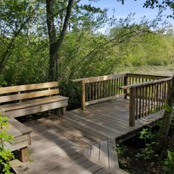
We find this a very enjoyable place for a quiet walk. Although not all man made sounds are masked, the sounds of crickets and birds and the wind in the tree tops gently serenaded us on our most recent walk through the wood. Easy to find, the gravel car park is a very good size. There is a covered information kiosk off the car park and another three-sided sign board at the trail head, along with a small covered Trail Map box on a post. Signs everywhere tell you this is *not* a dog friendly location. The early part of this trail is one person wide, fairly even ground. It wends it's way along the edge of two meadows. After the second meadow, the path becomes much broader and remains fairly clear of roots and rocks until you reach the old stone fireplace at Carr Pond where the pathway turns into the wood and becomes more difficult to navigate. If you have a sturdy, off-road baby pram or wheelchair, you may be able to travers this early part of the trail with a little assistance. You will need to navigate around the 'no dog' sign in the middle of the path at the trail head and the narrow meadow portion. After that the trail widens and would be easier to traverse in dry conditions. We branched off on to the CP trail into the wood. The trail takes a short, steep climb at the beginning and then levels out. Single wide, the trail is clearly blazed, even under a carpet of autumn foliage. CP trail is the white trail mark and signs for other trails are very well signed. Carr Pond is about half way round on the CP trail, before looping back and returning to the meadow. We 'strolled' the trail, enjoying being in the wood, stopped at the pond a couple of times to enjoy the serenity. You can most definitely walk it faster, but we took about an hour to make the loop. There are no benches to rest on along this trail, or to sit and enjoy the pond views. In the wooded section you need to keep an eye on roots and rocks. There are a couple of short boardwalks over low area near the pond. It was cooler under the trees making me glad I remembered a hat and jacket along with my water. No facilities of any kind are available, so go, before you visit. Definitely an easy trail for those who are sturdy on their feet. Wear appropriate footwear, and enjoy the quiet peace of the wood and pond. read more


 - Hiking Near Me - Coventry, Rhode Island")


2 years ago
Enjoyed a very peaceful Autumn trek along the several miles of trail spread across the 295 acres or so of land that comprises the Maxwell Mays Wildlife Refuge. Located on the farm estate of the late Maxwell Mays (a painter known for his "depictions of bygone scenes of cities and bucolic villages in his home state of Rhode Island"), the land is maintained by the Rhode Island Audobon Society. Easy-going... couple of brief ups and downs here and there but nothing significant. Well-maintained trail system, easy to follow the colored blazes, and a couple of interesting and historical sights along the way. The changing landscape offered variety to the hike, from meadows to covered forest canopies, wetlands, and the somewhat centralized 11-acre Carr Pond. I performed a couple figure 8's along the white (Carr Pond), yellow (Hammitt Hill), and blue by-pass trails to take it all in and put in about 4 miles or so. A historical cemetery, stone chimney (that was likely attached to a past, temporary hunting/fishing lodge), carriage roads, a farmhouse foundation, countless rock walls (as the land used to be part of a working farm), as well as glacial rock outcroppings. I was pleased to learn there is a private, lakefront cottage on the property available to rent between May and October each year. Dock for lake access, canoes, screened-in porch, fires... sounds like a perfect weekend getaway. Definitely keeping this in mind. The views of foliage across the calm waters of the pond were beautiful from the trails. Imagine the views are similar from this property. No dogs, bikes, or horses allowed on the property. Open sunrise to sunset. Consider taking a peek at the Interpretive Trail Guide available online if you have kiddos in tow. read more


Accessible and easy hike on well-marked trails, with some nice water views, old field stone walls, and impressive glacial boulders. There are two trails - Carr Pond (white blaze) and Hammitt Hill (yellow) - but both (ca. 3 miles cumulative) can be done in a leisurely 1.5 hours or so. There are a couple of steep climbs near the Hammitt Hill portion, but not too bad, and enough for a change of pace. The trails are mostly woodland but you do follow the shoreline of Carr Pond which is very pretty and peaceful. Hiking the trails at this time of year was very pleasant as the weather was cooler, not buggy, gorgeous leaf colors, and more light and visibility as there were fewer leaves. A couple of neat "finds" along the trail: An historic cemetery, remains of a farmhouse basement and fireplace, and some truly massive glacial boulders! N.B. There are no restrooms or porta-potties at the parking lot/trailhead, so you will have to make like a bear if needed! read more


 - Hiking Near Me - Coventry, Rhode Island")


15 years ago
I would like this land to breathe Maxwell Mays was one of Rhode lsland's best known folk artists and for decades he was in great demand not only for his wonderful and historic Rhode Island art but also for his speaking and storyteller abilities. Maxwell was also a philanthropist and environmentalist and when he died at the age of 91 donated his land to the Audubon Society so future generations could enjoy it. The roughly 300 acre refuge actually started as a farm way back in the early 18th century and the area continued as a working farm with large herds of cattle and sheep until Mays finally bought the property in 1941. Maxwell May lived and loved the property until his death in 2009. The area was dedicated this year as the Maxwell Mays Wildlife Refuge is and is now part of the Audubon Society. The refuge is a quite place with mature forest and wetlands. The roughly 11 acre Carr Pond is in the middle and at the right time of the year lots of birds, amphibians, reptiles, fish and even beaver and otter can be seen. The hiking is easy with few hills or rocks and all the trails are very well marked. A nice place to hike for people that aren't deep wood wise or just want a simple walk in the forest. The present trial is only about a mile and a half long but by next spring another trial up Hammitt Hill will open that will make the hiking a bit more interesting. This isn't a place for a strenuous workout, it's a pleasant and quiet area that should be taken slowly to fully appreciate the beautiful scenery and subtle wildness. It will be great for snowshoeing and cross-country skiing in the winter because of the lack of nasty hills and dangerous ledges. Certainly not the place to go if you want some exciting and lung burning hiking, there are plenty of other hikes nearby that will give you that. This is a peaceful place to see some wildlife, hear and smell nature and take part in some quiet contemplation. Maxwell stated that he wanted this land to breathe and stay open because it has been very good to him. His gift will ensure that the old farm will continue to be good to others. read more


5 years ago
10 years ago
8 years ago
With a break in the weather we wanted to get out and enjoy some fresh air. We pulled up our 'AllTrails' app and decided to explore this hiking/walking path. This refuge is clearly marked by a decent sized sign from the road so you shouldn't miss it. There is also plenty of parking but no facilities. At the beginning of the path, the rules are clearly displayed and you can grab a map. Please note, dogs are not allowed. There are two different trails, one all around the property and one that cuts through the middle if you don't want to take the full hike (which I believe is 3 miles). The paths are clearly marked by markers painted on the trees and signs. You do have to watch your footing because there are a lot of roots, fallen trees and puddles (if it rained recently) that sometimes obstruct your path but overall it wasn't too bad. We saw an old fireplace (see pics) which was interesting as well as an old family cemetery (Carr family). Overall we had a great time exploring these paths and would visit again in the nicer weather so we can hopefully see the wildflowers that I've read about in other reviews. read more


9 years ago
Absolutely glad we took the trek down today. There are two trails (white and yellow) on the map but while we were in the woods there was suddenly a blue trail. However, it wasn't on my map so I wasn't going to see where it went. If you've read my other reviews, then you know the two things that are a must for me; trail maps and clearly marked trails. This has both. The Carr Pond trail is a quick loop around. However, it meets up with the Hammitt Hill trail that loops around the pond back to CP trail. We hit that entire trail and I'm glad we did. CP is nice but flat. HH was more hilly and had more character. The hills and rocks were nothing strenuous and I still consider this an easy trail. I broke my arm about a month ago on a hike and I don't look at rocks the same anymore. I think they're all there to destroy me. So while the HH trail was more rocky it didn't break me. I had both my kids with me (6 and 14) and we made it in and out in approximately an hour and a half. Not a long hike but perfect with the kids. It has plenty of parking and trail maps at the entrance. I see no reason why dogs wouldn't be welcomed and I saw no "no dogs" listed anywhere. It was a really good morning and I'd recommend the adventure. Edited to read: the map says no dogs. Sorry. read more


12 years ago
More info about Maxwell Mays Wildlife Refuge
Ask the Community - Maxwell Mays Wildlife Refuge
Review Highlights - Maxwell Mays Wildlife Refuge
You might also consider


Maxwell Mays Wildlife Refuge - hiking - Updated June 2026
Best of Coventry
People found Maxwell Mays Wildlife Refuge by searching for…
Things to Do in Coventry, Rhode Island
Parks in Coventry, Rhode Island
Fishing in Coventry, Rhode Island
Playgrounds in Coventry, Rhode Island
Star Gazing in Coventry, Rhode Island
Hiking Trails With Waterfalls in Coventry, Rhode Island
Watch Sunset in Coventry, Rhode Island
Sunset View in Coventry, Rhode Island
Sunrise View in Coventry, Rhode Island
Off Road Trails in Coventry, Rhode Island
Fall Foliage in Coventry, Rhode Island
Parks for Kids in Coventry, Rhode Island
Bike Paths in Coventry, Rhode Island
Scenic Views in Coventry, Rhode Island
Boardwalk in Coventry, Rhode Island
Hiking With Kids in Coventry, Rhode Island
Dog Friendly Hiking Trails in Coventry, Rhode Island
Swimming Lakes in Coventry, Rhode Island
Beautiful Views in Coventry, Rhode Island
Walking Trails in Coventry, Rhode Island
Stroller Friendly Hikes in Coventry, Rhode Island
Bird Sanctuary in Coventry, Rhode Island
Trending Searches in Coventry, RI
Amusement Parks near Maxwell Mays Wildlife Refuge
Beaches near Maxwell Mays Wildlife Refuge
Bird Sanctuary near Maxwell Mays Wildlife Refuge
Black Owned Nail Salons near Maxwell Mays Wildlife Refuge
Boat Rental near Maxwell Mays Wildlife Refuge
Cliff Jumping near Maxwell Mays Wildlife Refuge
Dog Friendly Things To Do near Maxwell Mays Wildlife Refuge
Fishing Spots near Maxwell Mays Wildlife Refuge
Free Kids Activities near Maxwell Mays Wildlife Refuge
Jet Ski Rental near Maxwell Mays Wildlife Refuge
Lakes near Maxwell Mays Wildlife Refuge
Outdoor Activities near Maxwell Mays Wildlife Refuge
Parks For Picnics near Maxwell Mays Wildlife Refuge
Public Pools near Maxwell Mays Wildlife Refuge
Public Shower near Maxwell Mays Wildlife Refuge
Rock Quarry near Maxwell Mays Wildlife Refuge
Running Trails near Maxwell Mays Wildlife Refuge
Scenic Drive near Maxwell Mays Wildlife Refuge
Secluded Spots near Maxwell Mays Wildlife Refuge
Soccer Store near Maxwell Mays Wildlife Refuge
Splash Pad near Maxwell Mays Wildlife Refuge
Strawberry Picking near Maxwell Mays Wildlife Refuge
Sunrise View near Maxwell Mays Wildlife Refuge
Swimming Holes near Maxwell Mays Wildlife Refuge
Swimming Lakes near Maxwell Mays Wildlife Refuge
Swimming Pools near Maxwell Mays Wildlife Refuge
Watch Sunset near Maxwell Mays Wildlife Refuge
Browse Articles
Browse Nearby
Browse Brands
Related Searches in Coventry, RI
Affordable Kayak Rental Services in Coventry, Rhode Island
Best Fishing Locations and Guides in Coventry, Rhode Island
Best Places for Horseback Riding in Coventry, Rhode Island
Best Places for Stunning Views in Coventry, Rhode Island
Check Out Off Road Trails in Coventry, Rhode Island
Discover Kid Friendly Hiking Trails in Coventry, Rhode Island
Discover Scenic Bike Paths in Coventry, Rhode Island
Discover Scenic Mountain Bike Trails Near Coventry, Rhode Island
Discover a Hiking Trail in Coventry, Rhode Island
Discover the Best Night Hike Trails in Coventry, Rhode Island
Discover the Best Running Track in Coventry, Rhode Island
Enjoy Camping Adventures Around Coventry, Rhode Island
Enjoy Exciting Mountain Biking Adventures in Coventry, Rhode Island
Enjoy Kayaking Adventures in Coventry, Rhode Island
Enjoy Tent Camping Spots Around Coventry, Rhode Island
Enjoy Water Activities and Fun in Coventry, Rhode Island
Enjoy the Best Picnic Spots and Ideas in Coventry, Rhode Island
Enjoy the Best Walking Trails in Coventry, Rhode Island
Exciting Cliff Jumping Spots in Coventry, Rhode Island
Explore Beautiful Parks and Green Spaces in Coventry, Rhode Island
Explore Easy Hikes Perfect for All in Coventry, Rhode Island
Explore Fun Activities to Do in Coventry, Rhode Island
Explore Popular Campgrounds Near Coventry, Rhode Island
Explore Popular Scenic Overlook Points in Coventry, Rhode Island
Explore the Best Beach Spots in Coventry, Rhode Island
Explore the Best Boating Spots in Coventry, Rhode Island
Explore the Best Swimming Holes Around Coventry, Rhode Island
Family Friendly Hiking With Kids in Coventry, Rhode Island
Find Beautiful Views in Coventry, Rhode Island
Find Parks and Recreation Activities in Coventry, Rhode Island
Find Popular Ziplining Spots Around Coventry, Rhode Island
Find the Best Parks for Picnics in Coventry, Rhode Island
Find the Best Playgrounds to Visit in Coventry, Rhode Island
Find the Best Scenic View Locations in Coventry, Rhode Island
Hiking Trails With Waterfalls in Coventry, Rhode Island
Must-See Sights to Explore in Coventry, Rhode Island
Off Leash Dog Hiking Trails in Coventry, Rhode Island
Plan Nature Center Visits in Coventry, Rhode Island
Plan a Scenic Drive Route Near Coventry, Rhode Island
Popular Fishing Spots to Explore in Coventry, Rhode Island
Popular Outdoor Activities to Try in Coventry, Rhode Island
Popular Picnic Spots to Visit in Coventry, Rhode Island
Popular Things to Do in Coventry, Rhode Island
Safe River Swimming Areas in Coventry, Rhode Island
Safe and Fun Parks for Kids in Coventry, Rhode Island
Top Paddleboarding Activities in Coventry, Rhode Island
Top Running Trails to Explore in Coventry, Rhode Island
Top Swimming Lakes to Enjoy in Coventry, Rhode Island
People who viewed Maxwell Mays Wildlife Refuge also viewed
Trestle Trail
5 reviews
Hunt River Preserve
2 reviews
Fall River Heritage State Park
10 reviews
Esek Hopkins Field
2 reviews
Coventry Greenway
1 review
Chocolate Mill Overlook Park
1 review
Prudence Island Hiking Trails
1 review
Norman Bird Sanctuary
22 reviews
Lafayette Park
2 reviews
Washington Secondary Bike Way
6 reviews