Finally after passing the Overton Wildlife Management Area (abbreviated OWMA) a handful of years and exploring the landscape on Google Maps, this past Saturday I set my feet here, on a hiking adventure that lead me through the beautiful open spaces of the southernmost reaches of the Moapa Valley.
OWMA encompass 17,665 acres of a desert riparian habitat where the town of Overton merges with the breathtaking landscapes of the Lake Mead National Recreation Area and Valley of Fire State Park. This is a popular spot for viewing wildlife, hiking, horseback riding, hiking, and hunting. When talking wildlife, OWMA is rich in wildlife. According to their website there are 265 species of birds seen here, 47 species of mammals, 22 species of fish, and 28 species of reptiles and amphibians.
When it comes to wildlife there are many that come here to shoot them with cameras then others who come here to shoot them with guns. It is important to keep in mind that hunting season is September 1 to the middle of February. It is recommended that you call (702)-397-2142 to ask if it open the day that you plan to visit. Essentially, OWMA is a Spring hiking park.
From this point forward, I will discuss my first hand experience here. It was part 3 of an all day adventure that started with a cruise on the North Shore Drive followed by the Lost City Museum. It tied in with the Lost City Museum because it is a part of the area it focused on where it ties in with the North Shore Drive in Lake Mead National Recreation Area because the Muddy River that flows through OWMA area discharges into Lake Mead.
From Route 169, I pulled into a dirt road that ended at a parking area by a kiosk. On the way I passed a couple camping sites. From there I opened a gate before exploring the southern portion of OWMA. The hiking trail was a dirt road that reached out as far as the eye can see. Bordering it were forests of mesquite interspersed with cottonwoods and riparian plants. To avoid the Yelp character limit, I will get to the point of saying that the highlight of the hike were the fields the dirt road overlooked. The circular dirt road connected to additional dirt roads bordering the fields.
The fields resembled life and death. Both Pintail & Wilson Ponds were dried pond peds. Nearby green fields adorned a landscape bordered by the mountains of Valley of Fire & Virgin Range in addition to a mesa. Interestingly the green fields represented part of the 160 acres used for farming. It was a surprise to see cattle on the land. It was another surprise to see how tiny the Muddy River was when I explored a spur trail.
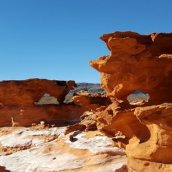
As I explored the OWMA, I was amazed by how different it was from the Mars landscape of Valley of Fire and North Shore Drive outside it. This reminded me more of hiking in a Florida Prairie than Mars. To put it simply, I was just amazed.
I plan to return to OWMA next Spring. This time, I will skip the Lost City Museum and spend even more time here.
When I return, I will be reaching it by ways of the North Shore Drive ($20 for 7 days or $40 annual pass). The sixty miles along the park road extended my adventure to and from Las Vegas. read more