Smith Mountain Via Bear Creek Trail Photos


You might also consider


More like Smith Mountain Via Bear Creek Trail
Recommended Reviews - Smith Mountain Via Bear Creek Trail
Start your review...


Reviews With Photos


It's deep within Angeles National Forest. Get on the 39 North, past East Fork turn, and keep going down past the West Fork trail and parking lots crowded with people (about 8 miles past). 1/4 mile before you hit Coldbrook Camp, you'll see a bathroom outhouse to your left with a paved parking lot and a sign that says "Bear Creek Tr. No. 239W10" (http://www.yelp.com/biz_photos/kaJEwnOL24A_Nu4fWUqj1w?select=Ri135hctmaAK7DMGn-icug#Ri135hctmaAK7DMGn-icug) and this is the start of the trail. The trail quickly picks up in elevation during the first half mile and then it's more gradual. The trail markers are located at each mail to your left on a metal pole next to a wooden block (http://www.yelp.com/biz_photos/kaJEwnOL24A_Nu4fWUqj1w?select=Ri135hctmaAK7DMGn-icug#WPAnRtBiDzaRTPbkpTxUKg) just in case you want to keep track of your progress. Some parts have a lot of vegetation and will require you to part branches and leaves away, make sure you check for ticks (1 was on my sock at the end). Lots of geckos hurrying their way across and down the path, I think they like to follow me because I swear I keep seeing the same one stalking me (maybe it's a sign for me to switch to Geico? har har). Once you hit about 3 miles you'll come to a clearing which is Smith Saddle. You have the start of the San Gabriel Wilderness ahead of you (http://www.yelp.com/biz_photos/kaJEwnOL24A_Nu4fWUqj1w?select=Ri135hctmaAK7DMGn-icug#aEuznqCxoaeJ2yE9rOT9XA) and then to the left lays the last 1/2 mile to the top of Smith Mountain (http://www.yelp.com/biz_photos/kaJEwnOL24A_Nu4fWUqj1w?select=Ri135hctmaAK7DMGn-icug#2Vh-g6XSHBAb4L5Q22Iy_w). To the right is a long and steep firebreak, I don't know what lays at the top but I'll find out maybe another time. Get some water, pysch yourself up, and attack it. There is a semi visible trail but you will have to use your hands to grab onto rocks and roots because it's quite steep. You'll definitely have to whack a few bushes and pull yourself up but the 360 degree panoramic view at the top is really worth it. Make sure to look for the register can (http://www.yelp.com/biz_photos/kaJEwnOL24A_Nu4fWUqj1w?select=SSPpLNVdodN2qpGt6Mt22g#SowXoUF_5E5F3Sax23yxeQ) by the U.S. geological survey marker http://www.yelp.com/biz_photos/kaJEwnOL24A_Nu4fWUqj1w?select=SSPpLNVdodN2qpGt6Mt22g#SSPpLNVdodN2qpGt6Mt22g) to record your name down and leave your mark at the top! On the way down, just take it slow to ensure you have good footing because otherwise, it's a looooong tumble down.


6 years ago
An excellent hiking opportunity about 25 minutes past the entry of Azusa canyon. The trail head is Bear Creek Trail. We hiked in 3 miles moderate uphill to the Smith saddle. Was beautiful as you can get a tremendous view of the San Gabriel mountains, now partially charred due to the recent fire. A quiet hike as we saw only a few other hikers on this 6 mile hike. read more


8 years ago
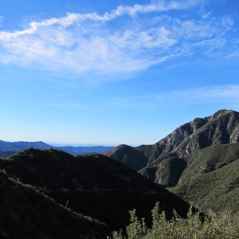
I enjoy this hike a lot, we were the only hikers on the trail for that day on Sunday. If you hate hiking echo mountain due to the crowd, then you will love this trail. It's about an 6.6 mile round trip. From the 210, take the CA-39 exit north 18.1 miles into the San Gabriel Mountains National Monument. Park at the large trailhead at Upper Bear Creek Trail - look for signs for the San Gabriel Wilderness and an outhouse. If you've hit Coldbrook Camp, head back 1/4 mile. Display your Adventure Pass. Near the top, there is a bit of overgrown plants, but passable. But want to wear pants. A bit of rock scrambling. Once you make it to the top, you can tell if you actually made it, there is USGS marker on a rock. Also, very little shade on the hike, so plan to carry plenty of water and sunscreen unless you hike early morning to beat the sun:). read more



11 years ago
This hike is 7 miles roundtrip out and back with 1,825' elevation gain/loss. The trail is single file with some loose rocks under foot. It starts out with a decent ascent for the first mile but nothing too difficult. The next 2 miles are very easy with very little ascent. There are wooden markers designating miles 1,2, and 3. There is no overhead shade. After mile 3, where you will see a small wooden bench, and straight ahead is the beginning of a very difficult climb. It is about 1/2 mile and an 800 ft scramble up to the peak. There are rocks to maneuver over and around, and you may need to use your hands to hold on or to propel yourself forward. The 360 degree views are worth the climb. parking - small lot at the trailhead. Adventure pass required. read more


It's deep within Angeles National Forest. Get on the 39 North, past East Fork turn, and keep going down past the West Fork trail and parking lots crowded with people (about 8 miles past). 1/4 mile before you hit Coldbrook Camp, you'll see a bathroom outhouse to your left with a paved parking lot and a sign that says "Bear Creek Tr. No. 239W10" (http://www.yelp.com/biz_photos/kaJEwnOL24A_Nu4fWUqj1w?select=Ri135hctmaAK7DMGn-icug#Ri135hctmaAK7DMGn-icug) and this is the start of the trail. The trail quickly picks up in elevation during the first half mile and then it's more gradual. The trail markers are located at each mail to your left on a metal pole next to a wooden block (http://www.yelp.com/biz_photos/kaJEwnOL24A_Nu4fWUqj1w?select=Ri135hctmaAK7DMGn-icug#WPAnRtBiDzaRTPbkpTxUKg) just in case you want to keep track of your progress. Some parts have a lot of vegetation and will require you to part branches and leaves away, make sure you check for ticks (1 was on my sock at the end). Lots of geckos hurrying their way across and down the path, I think they like to follow me because I swear I keep seeing the same one stalking me (maybe it's a sign for me to switch to Geico? har har). Once you hit about 3 miles you'll come to a clearing which is Smith Saddle. You have the start of the San Gabriel Wilderness ahead of you (http://www.yelp.com/biz_photos/kaJEwnOL24A_Nu4fWUqj1w?select=Ri135hctmaAK7DMGn-icug#aEuznqCxoaeJ2yE9rOT9XA) and then to the left lays the last 1/2 mile to the top of Smith Mountain (http://www.yelp.com/biz_photos/kaJEwnOL24A_Nu4fWUqj1w?select=Ri135hctmaAK7DMGn-icug#2Vh-g6XSHBAb4L5Q22Iy_w). To the right is a long and steep firebreak, I don't know what lays at the top but I'll find out maybe another time. Get some water, pysch yourself up, and attack it. There is a semi visible trail but you will have to use your hands to grab onto rocks and roots because it's quite steep. You'll definitely have to whack a few bushes and pull yourself up but the 360 degree panoramic view at the top is really worth it. Make sure to look for the register can (http://www.yelp.com/biz_photos/kaJEwnOL24A_Nu4fWUqj1w?select=SSPpLNVdodN2qpGt6Mt22g#SowXoUF_5E5F3Sax23yxeQ) by the U.S. geological survey marker http://www.yelp.com/biz_photos/kaJEwnOL24A_Nu4fWUqj1w?select=SSPpLNVdodN2qpGt6Mt22g#SSPpLNVdodN2qpGt6Mt22g) to record your name down and leave your mark at the top! On the way down, just take it slow to ensure you have good footing because otherwise, it's a looooong tumble down. read more


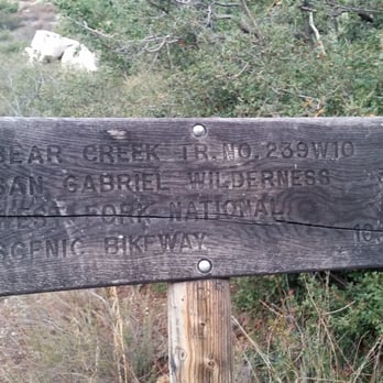
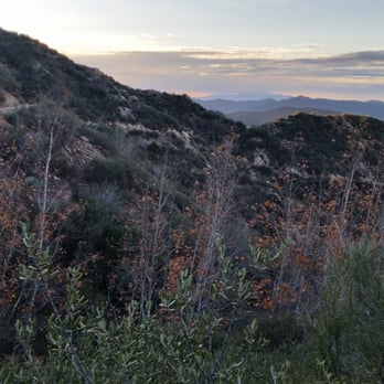
This was my first time hiking in Azusa part of the Angeles National Forest. Smith Mountain is approximately 30 mins from the start of the forest on Highway 39. The hike is approximately 6.6 miles and took me about 4 hours to complete roundtrip. If you drove by Coldbrook Campground, you've gone too far. There is also a gate just past the parking lot of this trail which is a good marker to where the trail is. There is a parking lot at the start of the trail. Adventure pass is required! The start of the trail is to the right of the outhouse where you'll see a wooden sign that says Bear Creek Tr. No. 239W10. As you start the trail, you pick up elevation pretty quickly but after about a mile, the trail flattens until you hit Smith Saddle which is where you will summit to Smith Mountain. There will be white and wooden poles marking each mile. The trail in the beginning will double back itself for a bit so you'll be looking at the same views but as you keep going, you'll be deep into the wilderness of the San Gabriel Mountains. Throughout the trail, you may need to whack a few bushes and branches here and there but overall it was very smoothand well maintained. You'll know you're approaching Smith Saddle when you see two wooden stands and the steep trail up to Smith Mountain. As you summit the mountain, take your time and go slow. You will have to grab onto rocks and branches and just follow the trail. If it does not look like a trail or you can't go through it, DO NOT ATTEMPT TO GO. Find another route and continue. There were a couple times where I hit a roadblock, and had to hike down a bit and go around to access the trail. Anyways, as you continue this summit, you will come to a fake summit. You can see Smith Mountain from here, just continue hiking up. The good thing is you've done most of the hard part so this part to the top should be easy. Once you're there, enjoy the view! :) I read there was a registry near the USGS mark but I couldn't find it :( I don't think it's there anymore. I hiked at 6:30am in the morning this past Friday and there was absolutely no one on the trail. It was very cold in the early morning at about 45 degrees Fahrenheit but warmed up as I hiked the trail. The high that day was 60 degrees which was fine for me. It was mostly shady throughout the trail until I hit Smith Saddle and summit the mountain. It was definitely mostly sunny on the trail when I was heading back around 9am. It felt great to be one with nature and to be the only one at the top. As I was coming down around 9am, I saw more people on the trail. This trail isn't really a popular one so you don't have to worry about crowds! Tips: - I would definitely wear long pants on this trail. You go through quite a bit of bushes and shrubs. It would help to also wear long sleeves. - As always, bring plenty of water. I always bring least 2 liters of water just in case. -Snacks to munch on as you enjoy the view at the top or along the trail. read more






10 years ago

12 years ago
More info about Smith Mountain Via Bear Creek Trail
Hwy 39
Azusa, CA 91702
Directions
Hours
Outdoor Amenities
Ask the Community - Smith Mountain Via Bear Creek Trail
You might also consider





























Smith Mountain Via Bear Creek Trail - hiking - Updated August 2026
Best of Azusa
People found Smith Mountain Via Bear Creek Trail by searching for…
Trending Searches in Azusa, CA
Antiques near Smith Mountain Via Bear Creek Trail
Barbershop For Men near Smith Mountain Via Bear Creek Trail
Beautiful Views near Smith Mountain Via Bear Creek Trail
Bike Shop near Smith Mountain Via Bear Creek Trail
Bird Sanctuary near Smith Mountain Via Bear Creek Trail
Cliff Jumping near Smith Mountain Via Bear Creek Trail
Consignment Shops near Smith Mountain Via Bear Creek Trail
Cruising Spots near Smith Mountain Via Bear Creek Trail
Dog Friendly Things To Do near Smith Mountain Via Bear Creek Trail
Dog Friendly Trails near Smith Mountain Via Bear Creek Trail
Ear Piercing near Smith Mountain Via Bear Creek Trail
Eyebrow Threading near Smith Mountain Via Bear Creek Trail
Flower Fields near Smith Mountain Via Bear Creek Trail
Free Picnic Areas near Smith Mountain Via Bear Creek Trail
Kids Haircut near Smith Mountain Via Bear Creek Trail
Lakes near Smith Mountain Via Bear Creek Trail
Lookout Points near Smith Mountain Via Bear Creek Trail
Mini Golf near Smith Mountain Via Bear Creek Trail
Nature Trails near Smith Mountain Via Bear Creek Trail
Night Hike near Smith Mountain Via Bear Creek Trail
Off Road Trails near Smith Mountain Via Bear Creek Trail
Outdoor Activities near Smith Mountain Via Bear Creek Trail
Parks near Smith Mountain Via Bear Creek Trail
Pedicure near Smith Mountain Via Bear Creek Trail
Permanent Makeup near Smith Mountain Via Bear Creek Trail
Picnic Areas near Smith Mountain Via Bear Creek Trail
Picnic Spots near Smith Mountain Via Bear Creek Trail
Preschools near Smith Mountain Via Bear Creek Trail
Public Golf Courses near Smith Mountain Via Bear Creek Trail
Public Pools near Smith Mountain Via Bear Creek Trail
River Swimming near Smith Mountain Via Bear Creek Trail
Rock Quarry near Smith Mountain Via Bear Creek Trail
Scenic Night View near Smith Mountain Via Bear Creek Trail
Scenic Overlook near Smith Mountain Via Bear Creek Trail
Sunrise View near Smith Mountain Via Bear Creek Trail
Swimming Holes near Smith Mountain Via Bear Creek Trail
Trading Card Shops near Smith Mountain Via Bear Creek Trail
Used Furniture Stores near Smith Mountain Via Bear Creek Trail
Watch Sunset near Smith Mountain Via Bear Creek Trail
Waterfalls near Smith Mountain Via Bear Creek Trail
Waterfalls And Swimming Holes near Smith Mountain Via Bear Creek Trail
Browse Nearby
BEST of Azusa, California Coffee near Smith Mountain Via Bear Creek Trail
BEST of Azusa, California Restaurants near Smith Mountain Via Bear Creek Trail
BEST of Azusa, California Parks near Smith Mountain Via Bear Creek Trail
BEST of Azusa, California Breakfast near Smith Mountain Via Bear Creek Trail
BEST of Azusa, California Campgrounds near Smith Mountain Via Bear Creek Trail
BEST of Azusa, California Gym near Smith Mountain Via Bear Creek Trail
Browse Brands
Related Searches in Azusa, CA
Affordable Bike Repair Services in Azusa, California
Affordable Cheap Bike Tune Up Services in Azusa, California
Affordable Kayak Rental Services in Azusa, California
Best Dirt Bike Riding Spots in Azusa, California
Best Dog Hiking Trails Around Azusa, California
Best Electric Bike Rental Services in Azusa, California
Best Fishing Locations and Guides in Azusa, California
Best Nature Trails for Hiking in Azusa, California
Best Places for Horseback Riding in Azusa, California
Best Sledding Spots and Fun in Azusa, California
Check Out Off Road Trails in Azusa, California
Convenient Bike Sharing Programs in Azusa, California
Discover Dog Friendly Trails to Explore in Azusa, California
Discover Easy Hiking Trails Near Azusa, California
Discover Kid Friendly Hiking Trails in Azusa, California
Discover Popular Bike Tours in Azusa, California
Discover Popular Bike Trails in Azusa, California
Discover Scenic Bike Paths in Azusa, California
Discover Scenic Mountain Bike Trails Near Azusa, California
Discover Walking Parks in Azusa, California Near You
Discover a Hiking Trail in Azusa, California
Discover the Best Night Hike Trails in Azusa, California
Dog-Friendly Hikes With Dogs in Azusa, California
Enjoy Biking Adventures Around Azusa, California
Enjoy Camping Adventures Around Azusa, California
Enjoy Hiking Adventures in Azusa, California
Enjoy Kayaking Adventures in Azusa, California
Enjoy Off Leash Dog Hikes in Azusa, California
Enjoy Scenic Dirt Bike Trails Around Azusa, California
Enjoy Scenic Places to Walk in Azusa, California
Enjoy Tent Camping Spots Around Azusa, California
Enjoy a Beautiful Waterfall Hike in Azusa, California
Enjoy the Best Walking Path in Azusa, California
Enjoy the Best Walking Trails in Azusa, California
Exciting Snow Tubing Experiences in Azusa, California
Explore BMX Bike Shops Near Azusa, California
Explore Beautiful Parks and Green Spaces in Azusa, California
Explore Bike Rentals Throughout Azusa, California
Explore Cycling Stores in Azusa, California
Explore Easy Hikes Perfect for All in Azusa, California
Explore Electric Bikes Available in Azusa, California
Explore Fun Activities to Do in Azusa, California
Explore Popular Campgrounds Near Azusa, California
Explore Popular Dog Walking Trails in Azusa, California
Explore Popular Scenic Overlook Points in Azusa, California
Explore Popular Scenic Views Near Azusa, California


