Road To Nowhere Hike Photos


You might also consider
More like Road To Nowhere Hike
Recommended Reviews - Road To Nowhere Hike
Start your review...

Reviews With Photos

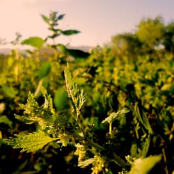
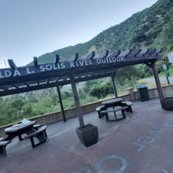
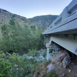
If you are familiar to the Bridge to Nowhere Hike, which is located nearby, this is the tunnel version. Apparently, in the 1950s and 60s, this road was built as an intended escape route should Los Angeles be attacked with nuclear weapons. This hike is 5 miles roundtrip, up and back, with 750' elevation gain/loss. It is a very easy hike and would be good for dogs and children. The trail is a wide, smooth, dirt fire road. There is very little climb involved. About 1.5 miles into the hike, you will see the first of two tunnels. Proceed through the first and continue on to the 2nd one, which is almost a mirror image. That concludes the hike, hence the name of the hike. If you dare, you could continue on the narrow trail beyond to attempt the very difficult Rattlesnake Peak hike. parking - adventure pass required for the lot driving directions: From I-210 in Azusa, take Azusa Avenue (Hwy 39) north about 12 miles to the junction at the East Fork Road (8.6 miles from the forest station at the mouth of the canyon). Turn right (east). Cross the bridge and drive 3.3 miles to Shoemaker Canyon Road on the left. Turn left unto Shoemaker Road and drive 2 miles on paved road to the locked gate. Park in the parking area.

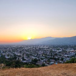
I hiked this trail yesterday (12/20/20) and it will be a one and done for me...nothing interesting enough for me to come back to again. There are some things that I like about it and that would be that it is not crowded at all and it easy to find parking (Adventure Pass is required though). Also,there are some pretty good views of the surrounding mountains and the two tunnels are pretty cool. It is located just before the very popular Bridge to Nowhere hike and there are a couple spots where you can look down and view that trail below. This is basically the Road to Nowhere and it is wide and there will be two tunnels that you will pass through at about 1.5 and around 2.5 miles in with the first one having quite a bit of grafitti. This road is also where people start for the challenging Rattlesnake Peak hike and there is a small side trail to the left that people use a little over a mile after starting the hike on the road that people access to do that hike. We turned around after going through the 2nd tunnel and I think the "road" ends a little after that. My app that I was using to record the distance had trouble when I entered the tunnels so I don't know how long we hike but I would estimate about 5 miles total and it took us a little under 2 hours. This trail is not hard and there is minimal incline so it is good for the family and dog and young children or adults who are not in the greatest shape can handle it. read more


5 years ago
Tunnels to nowhere. This is a good hike. For the days you wake up late. Want to come on a simple walk. The tunnels to nowhere is perfect for that. It has a good ascension, beautiful views, and two very nice historical tunnels. read more

6 years ago
This is an easy hike to the tunnels to nowhere. Approximately 6 miles. Interesting art in the tunnels. They were built for a highway during the cold war to save angelenos from the Russians in case of an attack. The highway was to begin in the San Gabriel and end in the Mojave desert. However, it was never completed. read more


11 years ago
If you are familiar to the Bridge to Nowhere Hike, which is located nearby, this is the tunnel version. Apparently, in the 1950s and 60s, this road was built as an intended escape route should Los Angeles be attacked with nuclear weapons. This hike is 5 miles roundtrip, up and back, with 750' elevation gain/loss. It is a very easy hike and would be good for dogs and children. The trail is a wide, smooth, dirt fire road. There is very little climb involved. About 1.5 miles into the hike, you will see the first of two tunnels. Proceed through the first and continue on to the 2nd one, which is almost a mirror image. That concludes the hike, hence the name of the hike. If you dare, you could continue on the narrow trail beyond to attempt the very difficult Rattlesnake Peak hike. parking - adventure pass required for the lot driving directions: From I-210 in Azusa, take Azusa Avenue (Hwy 39) north about 12 miles to the junction at the East Fork Road (8.6 miles from the forest station at the mouth of the canyon). Turn right (east). Cross the bridge and drive 3.3 miles to Shoemaker Canyon Road on the left. Turn left unto Shoemaker Road and drive 2 miles on paved road to the locked gate. Park in the parking area. read more


8 years ago
First off this isn't the hiking trail to the bridge to nowhere. The hiking trail pretty much ends when you can't follow an actual road to follow. There is not shaded areas and is extreme hot during the summer. There are 2 tunnels that are up ahead with cool graffiti. There are a couple bee farms, that means there are a lot of bees. The bees don't bother you unless you bother them. read more
More info about Road To Nowhere Hike
Shoemaker Canyon Rd
34.233679, -117.770789
Azusa, CA 91702
Directions
Hours
Outdoor Amenities
You might also consider


Road To Nowhere Hike - hiking - Updated June 2026
Best of Azusa
People found Road To Nowhere Hike by searching for…
Bike Trails in Azusa, California
Things to Do in Azusa, California
Easy Hikes in Azusa, California
Abandoned Places in Azusa, California
Scenic Overlook in Azusa, California
Redwood Forest in Azusa, California
Mountain Biking in Azusa, California
Scenic View in Azusa, California
Waterfalls and Swimming Holes in Azusa, California
Rattlesnake in Azusa, California
Tent Camping in Azusa, California
Beautiful Views in Azusa, California
Dog Friendly Trails in Azusa, California
Swimming Lakes in Azusa, California
Night Hiking in Azusa, California
Shaded Hike in Azusa, California
Paved Walking Trails in Azusa, California
Hiking Trails Kid Friendly in Azusa, California
Picnic Areas in Azusa, California
Trending Searches in Azusa, CA
Black Owned Nail Salons near Road To Nowhere Hike
Boat Rental near Road To Nowhere Hike
Cliff Jumping near Road To Nowhere Hike
Day Trips near Road To Nowhere Hike
Fishing Spots near Road To Nowhere Hike
Jet Ski Rental near Road To Nowhere Hike
Kayak Rental near Road To Nowhere Hike
Lakes & Ponds near Road To Nowhere Hike
Off Road Trails near Road To Nowhere Hike
Outdoor Activities near Road To Nowhere Hike
Places To Walk Around near Road To Nowhere Hike
Public Shower near Road To Nowhere Hike
River Swimming near Road To Nowhere Hike
Rock Quarry near Road To Nowhere Hike
Running Trails near Road To Nowhere Hike
Scenic Night View near Road To Nowhere Hike
Scenic Overlook near Road To Nowhere Hike
Secluded Spots near Road To Nowhere Hike
Soccer Store near Road To Nowhere Hike
Splash Pad near Road To Nowhere Hike
Strawberry Picking near Road To Nowhere Hike
Sunrise View near Road To Nowhere Hike
Swimming Holes near Road To Nowhere Hike
Swimming Lakes near Road To Nowhere Hike
U Pick Farms near Road To Nowhere Hike
Watch Sunset near Road To Nowhere Hike
Browse Articles
Browse Nearby
Browse Brands
Related Searches in Azusa, CA
Best Fishing Locations and Guides in Azusa, California
Best Nature Trails for Hiking in Azusa, California
Best Places for Horseback Riding in Azusa, California
Check Out Off Road Trails in Azusa, California
Discover Dog Friendly Trails to Explore in Azusa, California
Discover Kid Friendly Hiking Trails in Azusa, California
Discover Scenic Hiking Trails in Azusa, California
Discover Scenic Mountain Bike Trails Near Azusa, California
Discover Scenic Waterfall Spots in Azusa, California
Discover Top Nature Parks to Visit in Azusa, California
Discover Walking Parks in Azusa, California Near You
Discover a Hiking Trail in Azusa, California
Discover the Best Night Hike Trails in Azusa, California
Discover the Best Running Track in Azusa, California
Dog-Friendly Hikes With Dogs in Azusa, California
Enjoy Camping Adventures Around Azusa, California
Enjoy Exciting Mountain Biking Adventures in Azusa, California
Enjoy Kayaking Adventures in Azusa, California
Enjoy Tent Camping Spots Around Azusa, California
Enjoy a Beautiful Waterfall Hike in Azusa, California
Enjoy a Peaceful Nature Walk in Azusa, California
Enjoy the Best Walking Path in Azusa, California
Enjoy the Best Walking Trails in Azusa, California
Exciting Cliff Jumping Spots in Azusa, California
Explore Beautiful Parks and Green Spaces in Azusa, California
Explore Easy Hikes Perfect for All in Azusa, California
Explore Fun Activities to Do in Azusa, California
Explore Popular Campgrounds Near Azusa, California
Explore the Best Beach Spots in Azusa, California
Explore the Best Trail Options in Azusa, California
Family Friendly Hiking With Kids in Azusa, California
Find Beautiful Views in Azusa, California
Find Parks and Recreation Activities in Azusa, California
Find the Best Parks for Picnics in Azusa, California
Find the Best Scenic View Locations in Azusa, California
Great Places to Walk in Azusa, California
Hike the Popular Waterfall Trail in Azusa, California
Hiking Trails With Waterfalls in Azusa, California
Off Leash Dog Hiking Trails in Azusa, California
Plan a Scenic Drive Route Near Azusa, California
Popular Outdoor Activities to Try in Azusa, California
Popular Picnic Spots to Visit in Azusa, California
Safe River Swimming Areas in Azusa, California
Safe and Fun Parks for Kids in Azusa, California
Top Climbing Spots and Gyms in Azusa, California
Top Running Trails to Explore in Azusa, California
Top Swimming Lakes to Enjoy in Azusa, California
Top Swimming Spots and Pools in Azusa, California