Robert Louis Stevenson State Park Photos


You might also consider
More like Robert Louis Stevenson State Park
Recommended Reviews - Robert Louis Stevenson State Park
Start your review...

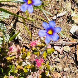
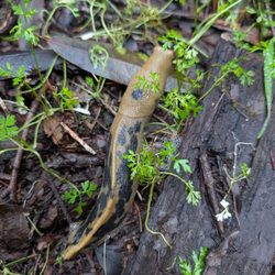
Reviews With Photos

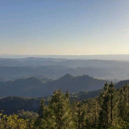
One of the best 360 views in the bay area, this 10 miler is definitely worth the trek. Yes, it is all uphill but it is not with the degree of difficulty as some mountain top hikes like Mission Peak in Fremont. Plus, there are some cool sites to distract you along the way. In the first mile of the hike keep an eye out for a plaque that marks the site of where Robert Louis Stevenson once held up in a cabin for his honeymoon. Hang a left once you hit the fire road and in the next half mile you will come across Bubble Rock where you can watch mountain climbers climb into the sky. Stay right at the first intersection and head for the North Peak. The view is breathtaking and you can see for miles on a clear day. Note: there is no main sign on Hwy 29 denoting the park, keep an eye out for parking and/or cars on either side of the road. Also, there is no water nor toilets at the staging area. Also, pack something special to have while you take in the view at the top :)

Great hike near Bothe-Napa State Park! Easy half-day hike up Mt. St. Helena with sweeping views of Napa Valley. Moderate difficulty with some very rocky sections. I wore Nike running shoes and was wishing for hiking shoes with some traction on the way down. Hiking poles would be a good idea if you're not as sure footed coming down trails with loose gravel. No restrooms or water at the trailhead (that I could see) so bring water and use the restroom before heading up. We turned around about 2 miles in but I definitely would want to return with more time and get to the summit.

Great uphill hike to the peak of Mount St. Helena w/ awesome views of Napa Valley along the way. First 1 mile is a shaded dirt trail through the woods and some rocks of the park. Next 4.7 miles is on dirt fire road, completely exposed to the sun. I don't recommend doing this hike on a hot summer afternoon. Last half mile to the peak is the steepest part of the hike. Once I got to the top it was 360 vuew of beautiful California. You are over 4,000 ft high! My friends and I had a small picnic at the top and took some great photos. The whole experience was about 4.5 hours. I would definitely do this again!

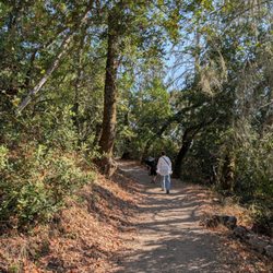
Mount Saint Helena Trail is a ~10 mile (5 miles each way) heavily trafficked out and back trail located near Calistoga, CA. The trailhead is right off of Lake County Highway. Despite what other reports say, while long, the hike is not very difficult. It has an elevation climb of about 2,000 feet but it is very gradual. The hike is basically two parts (described as you are heading up the trail) - The hike starts on Stevenson Memorial Trail, climbing just under a mile and passing through the area where the famed author Robert Louis Stevenson ("Kidnapped," "Treasure Island) honeymooned with his new bride in 1880.this part of the trail has lots of shade and tends to be on the cooler side. This isn't very scenic but is pleasant. Next in line is the Mount St. Helena Trail, once an old logging road but now a well-maintained fire / utility road, that climbs to the summit over about four miles. Note your turn-off point or you might miss it on the way back. This trail is an exposed, well-maintained Fire Road and has very little shade. The Fire Road offers many majestic views. Weather is a major wild card at Mount St. Helena -- it's one of the few areas near San Francisco that gets snow every year. The summit can be shrouded in fog and buffeted by high winds; make sure you're dressed for all the possibilities. I hiked here with my in-laws, wife, and children (9 and 6 years old). It took us well over 3 hours round trip. The hike has great views, but feels a bit "industrial" due to the very wide road you hike most of the time and the numerous radio towers at the top. Park hours: Sunrise to sunset Directions: Take highway 29 seven miles north of Calistoga. Tips: Get there early if you want a parking spot Bring sunscreen, water, and layers If hiking, watch out for mountain bikers

Came here just to get out of the house on a Saturday and I was pleasantly surprised. I got there early but I can definitely see how parking can be difficult later in the day. I wouldn't say this hike is difficult, just long. It does have a steady incline but it wasn't anything strenuous. Even with the fire damage the views were amazing. Probably one of the best hikes I've done in this particular area.

Sometimes it's not about how far you can see but where you happen to find yourself while doing it. That's what makes the hike to the summit of Mount Saint Helena, the premier destination in Robert Louis Stevenson State Park, such an appealing addition to a wine country visit to Napa. At 11 miles with 2,000 feet of elevation gained and lost, it's a challenging but by no means excruciating excursion. You can plan the hike for early morning (leaving the trailhead before 8 am), which allows you to return comfortably to your car by around noon - perfect timing for a BBQ at Buster's in Calistoga before an afternoon wine tasting at Frog's Leap, for example. The early start mitigates the midday heat, which could potentially be unrelenting in open chaparral near the summit. It also allows you to admire the sight of a fogged-in valley floor while you gaze down on it from the clear blue skies above. A lot of the trail follows a fire road to and from the summit, so you'll have plenty of time to look around in wonder at the ebb and flow of the fog fields below. It feels like flying, or gazing out at the ocean, and the quiet (leaving aside random road noise) is pretty overwhelming. Napa seems so small from these lofty heights, and so traffic-free. Just bring extra water, sturdy boots, and sun protection to feel safe and hydrated while doing so, or you'll never be fit enough for the wines and BBQ that await you down below. If you are carrying a backpack, I'd recommend trekking poles, too, given the ups and downs of the hike, but that's just me. I like to engage my arms and legs while hiking for a fuller workout and to protect my knees from too much pounding so that they are loose and ache-free for the very curvy drive back down to Calistoga once the hike is over. Watching the fog flow over and across the ridges, rises, and mountaintops is part of the appeal of the hike. So, too, the sight of the fog rising to reveal wineries and rows of tended grapevines, or even a hot air balloon or two as well as a towed-in glider plane. We saw both on our hike, alongside many dragonflies, lizards, and chipmunks and many expressive rocks and trees as we wound our way to the rockytop summit, where open views to the North and East awaited us and there was enough solitude to be shared by others. http://www.yelp.com/biz_photos/robert-louis-stevenson-state-park-calistoga#vqKsS1gSAWU-ge3T8gFdlQ http://www.yelp.com/biz_photos/robert-louis-stevenson-state-park-calistoga#t6W_cbVdj74oVtA5hAlZog http://www.yelp.com/biz_photos/robert-louis-stevenson-state-park-calistoga#-_Jm4vfpGZ1EYVpBhhRKiA http://www.yelp.com/biz_photos/robert-louis-stevenson-state-park-calistoga#szEX3CDAqIrcVfVErK6SrA Adding a morning hike to the summit of Mount St Helena can bring a certain something to a Napa visit that cannot be experienced from the valley floor, nor even from one of the exclusive mountain wineries around Mount Veeder or Howell Mountain. Because nothing - not even a cult Cab named after a screaming eagle - is as rare or more precious than the summit of Napa's highest peak (4,341 ft.), where the views are genuinely priceless and the soaring raptors are real.

This has to be my new favorite hike! The first 1.5 miles is incredible. It then turns into a fire road, but with amazing views. You start this hike at just around 2000'. The summit is up at 4343' and allows for some of the best views in all of Napa, Lake, and Sonoma counties combined! Do beware of the blatant Poison Oak, it is everywhere here. Leaves of 3, leave it be!!


1 year ago


There are many trails that you can go on at this state park. Like many have mentioned, the parking lot is rather small and so it's best to arrive early. The parking lot can fill up and in that case, you will have to park farther down and walk to the trailhead. The earlier you start your hike, the more likely it wil be that you find parking, especially if you are going on a weekend. There are no bathrooms near the parking lot. There is also not a parking fee. We took the Table Rock Trail, which is about 4.4 miles total. It had amazing views. The trail has a rock labyrinth along the way that was fun to see. The trail is very rugged with lots of rocks the father you hike up this trail so come prepared with lots of water, hiking shoes, and dress in layers. The views from the top were amazing. There were areas with ice on the trail so be careful when hiking. There is a more popular trail to Mount Saint Helena that is very popular as well. We have not taken that trail yet, although plan to in the future. We will definitely be back at this state park and look forward to exploring the other trails. read more

For Mount St Helena Trail: Difficulty: Moderate (due to distance, but elevation gain- easy) Mileage: ~10 miles Pets: No dogs View: Wine country, ocean on a clear day What to bring: (In winter) At least 1-2 liters, snacks, hat, jacket, gloves Parking: Highway 29 Fee: free Time: ~3-5 hours We came on 12/28. It was so cold. We started the hike at 7:30, the sun was hidden behind rain clouds and the wind was super strong. We summited in 1 hour and 50 minutes and it was so windy at the top. So bad that we literally summited then descend 1 minute later. Couldn't even chill at the top. We hit some slight snow. It was sprinkling but it was so cold, slight snow came down. We thought it was pollen until more came down and it made my jacket wet. It didn't stick much but it was pretty horrible. I thought my fingers were going to fall off. The view was still amazing, sort of gloomy but the sun started to come out once we went down. The first .8 miles is thru the woods, probably the hardest part of the 10 mile hike. The rest was super easy up a big well paved fire road. Didn't run into anyone going up. We finished in 3 hours with slightly jogging and and off down. Definitely recommend this hike. If I lived in area would probably use it to trail run. read more


One of the best 360 views in the bay area, this 10 miler is definitely worth the trek. Yes, it is all uphill but it is not with the degree of difficulty as some mountain top hikes like Mission Peak in Fremont. Plus, there are some cool sites to distract you along the way. In the first mile of the hike keep an eye out for a plaque that marks the site of where Robert Louis Stevenson once held up in a cabin for his honeymoon. Hang a left once you hit the fire road and in the next half mile you will come across Bubble Rock where you can watch mountain climbers climb into the sky. Stay right at the first intersection and head for the North Peak. The view is breathtaking and you can see for miles on a clear day. Note: there is no main sign on Hwy 29 denoting the park, keep an eye out for parking and/or cars on either side of the road. Also, there is no water nor toilets at the staging area. Also, pack something special to have while you take in the view at the top :) read more

 - Parks Near Me - Calistoga, California")

11 years ago
8 years ago
Great hike near Bothe-Napa State Park! Easy half-day hike up Mt. St. Helena with sweeping views of Napa Valley. Moderate difficulty with some very rocky sections. I wore Nike running shoes and was wishing for hiking shoes with some traction on the way down. Hiking poles would be a good idea if you're not as sure footed coming down trails with loose gravel. No restrooms or water at the trailhead (that I could see) so bring water and use the restroom before heading up. We turned around about 2 miles in but I definitely would want to return with more time and get to the summit. read more


 - Parks Near Me - Calistoga, California")


7 years ago
16 years ago
Great uphill hike to the peak of Mount St. Helena w/ awesome views of Napa Valley along the way. First 1 mile is a shaded dirt trail through the woods and some rocks of the park. Next 4.7 miles is on dirt fire road, completely exposed to the sun. I don't recommend doing this hike on a hot summer afternoon. Last half mile to the peak is the steepest part of the hike. Once I got to the top it was 360 vuew of beautiful California. You are over 4,000 ft high! My friends and I had a small picnic at the top and took some great photos. The whole experience was about 4.5 hours. I would definitely do this again! read more

Mount Saint Helena Trail is a ~10 mile (5 miles each way) heavily trafficked out and back trail located near Calistoga, CA. The trailhead is right off of Lake County Highway. Despite what other reports say, while long, the hike is not very difficult. It has an elevation climb of about 2,000 feet but it is very gradual. The hike is basically two parts (described as you are heading up the trail) - The hike starts on Stevenson Memorial Trail, climbing just under a mile and passing through the area where the famed author Robert Louis Stevenson ("Kidnapped," "Treasure Island) honeymooned with his new bride in 1880.this part of the trail has lots of shade and tends to be on the cooler side. This isn't very scenic but is pleasant. Next in line is the Mount St. Helena Trail, once an old logging road but now a well-maintained fire / utility road, that climbs to the summit over about four miles. Note your turn-off point or you might miss it on the way back. This trail is an exposed, well-maintained Fire Road and has very little shade. The Fire Road offers many majestic views. Weather is a major wild card at Mount St. Helena -- it's one of the few areas near San Francisco that gets snow every year. The summit can be shrouded in fog and buffeted by high winds; make sure you're dressed for all the possibilities. I hiked here with my in-laws, wife, and children (9 and 6 years old). It took us well over 3 hours round trip. The hike has great views, but feels a bit "industrial" due to the very wide road you hike most of the time and the numerous radio towers at the top. Park hours: Sunrise to sunset Directions: Take highway 29 seven miles north of Calistoga. Tips: Get there early if you want a parking spot Bring sunscreen, water, and layers If hiking, watch out for mountain bikers read more


Came here just to get out of the house on a Saturday and I was pleasantly surprised. I got there early but I can definitely see how parking can be difficult later in the day. I wouldn't say this hike is difficult, just long. It does have a steady incline but it wasn't anything strenuous. Even with the fire damage the views were amazing. Probably one of the best hikes I've done in this particular area. read more


12 years ago
Sometimes it's not about how far you can see but where you happen to find yourself while doing it. That's what makes the hike to the summit of Mount Saint Helena, the premier destination in Robert Louis Stevenson State Park, such an appealing addition to a wine country visit to Napa. At 11 miles with 2,000 feet of elevation gained and lost, it's a challenging but by no means excruciating excursion. You can plan the hike for early morning (leaving the trailhead before 8 am), which allows you to return comfortably to your car by around noon - perfect timing for a BBQ at Buster's in Calistoga before an afternoon wine tasting at Frog's Leap, for example. The early start mitigates the midday heat, which could potentially be unrelenting in open chaparral near the summit. It also allows you to admire the sight of a fogged-in valley floor while you gaze down on it from the clear blue skies above. A lot of the trail follows a fire road to and from the summit, so you'll have plenty of time to look around in wonder at the ebb and flow of the fog fields below. It feels like flying, or gazing out at the ocean, and the quiet (leaving aside random road noise) is pretty overwhelming. Napa seems so small from these lofty heights, and so traffic-free. Just bring extra water, sturdy boots, and sun protection to feel safe and hydrated while doing so, or you'll never be fit enough for the wines and BBQ that await you down below. If you are carrying a backpack, I'd recommend trekking poles, too, given the ups and downs of the hike, but that's just me. I like to engage my arms and legs while hiking for a fuller workout and to protect my knees from too much pounding so that they are loose and ache-free for the very curvy drive back down to Calistoga once the hike is over. Watching the fog flow over and across the ridges, rises, and mountaintops is part of the appeal of the hike. So, too, the sight of the fog rising to reveal wineries and rows of tended grapevines, or even a hot air balloon or two as well as a towed-in glider plane. We saw both on our hike, alongside many dragonflies, lizards, and chipmunks and many expressive rocks and trees as we wound our way to the rockytop summit, where open views to the North and East awaited us and there was enough solitude to be shared by others. http://www.yelp.com/biz_photos/robert-louis-stevenson-state-park-calistoga#vqKsS1gSAWU-ge3T8gFdlQ http://www.yelp.com/biz_photos/robert-louis-stevenson-state-park-calistoga#t6W_cbVdj74oVtA5hAlZog http://www.yelp.com/biz_photos/robert-louis-stevenson-state-park-calistoga#-_Jm4vfpGZ1EYVpBhhRKiA http://www.yelp.com/biz_photos/robert-louis-stevenson-state-park-calistoga#szEX3CDAqIrcVfVErK6SrA Adding a morning hike to the summit of Mount St Helena can bring a certain something to a Napa visit that cannot be experienced from the valley floor, nor even from one of the exclusive mountain wineries around Mount Veeder or Howell Mountain. Because nothing - not even a cult Cab named after a screaming eagle - is as rare or more precious than the summit of Napa's highest peak (4,341 ft.), where the views are genuinely priceless and the soaring raptors are real. read more


11 years ago
10 years ago
This has to be my new favorite hike! The first 1.5 miles is incredible. It then turns into a fire road, but with amazing views. You start this hike at just around 2000'. The summit is up at 4343' and allows for some of the best views in all of Napa, Lake, and Sonoma counties combined! Do beware of the blatant Poison Oak, it is everywhere here. Leaves of 3, leave it be!! read more


12 years ago
A very nice and not too onerous hike! I made it in 1.5 hours to the top of Mount Saint Helena, and in 1 hour down. The first part of the hike is a true trail, then it becomes a fire road further up. Very nice views of northern Napa Valley from up there! read more


12 years ago
Hiking was good some very nice views overlooking valleys. The trails were easy to find. Not a lot of parking but we were on the earlier side. read more

12 years ago
13 years ago
10 years ago
15 years ago
12 years ago
13 years ago
11 years ago
13 years ago
More info about Robert Louis Stevenson State Park
Ask the Community - Robert Louis Stevenson State Park
Is this trail currently open?
Review Highlights - Robert Louis Stevenson State Park
You might also consider


Robert Louis Stevenson State Park - parks - Updated June 2026
Best of Calistoga
People found Robert Louis Stevenson State Park by searching for…
Rock Climbing in Calistoga, California
Hiking Trails in Calistoga, California
Watch Sunset in Calistoga, California
Campgrounds in Calistoga, California
Redwood Trees in Calistoga, California
Things to Do in Calistoga, California
Tennis in Calistoga, California
Star Gazing in Calistoga, California
Sunrise View in Calistoga, California
Running Trails in Calistoga, California
River Swimming in Calistoga, California
Easy Hikes in Calistoga, California
Playgrounds in Calistoga, California
Walking Trails in Calistoga, California
Dog Friendly Hiking Trails in Calistoga, California
View Points in Calistoga, California
Camping Sites in Calistoga, California
Off Road Trails in Calistoga, California
Sunset View in Calistoga, California
Romantic Views in Calistoga, California
Picnic in Calistoga, California
Cliff Diving in Calistoga, California
Trending Searches in Calistoga, CA
Baseball Fields near Robert Louis Stevenson State Park
Beaches near Robert Louis Stevenson State Park
Black Owned Nail Salons near Robert Louis Stevenson State Park
Boat Rental near Robert Louis Stevenson State Park
Cliff Jumping near Robert Louis Stevenson State Park
Day Trips near Robert Louis Stevenson State Park
Dog Friendly Beaches near Robert Louis Stevenson State Park
Fishing Spots near Robert Louis Stevenson State Park
Free Kids Activities near Robert Louis Stevenson State Park
Free Picnic Areas near Robert Louis Stevenson State Park
Jet Ski Rental near Robert Louis Stevenson State Park
Kids Activities Outdoor near Robert Louis Stevenson State Park
Lakes near Robert Louis Stevenson State Park
Lakes & Ponds near Robert Louis Stevenson State Park
Off Road Trails near Robert Louis Stevenson State Park
Outdoor Activities near Robert Louis Stevenson State Park
Outdoor Basketball Courts near Robert Louis Stevenson State Park
Paddle Boat Rentals near Robert Louis Stevenson State Park
Parks With Pull Up Bars near Robert Louis Stevenson State Park
Pick Your Own Farms near Robert Louis Stevenson State Park
Picnic Parks near Robert Louis Stevenson State Park
Places To Walk Around near Robert Louis Stevenson State Park
Public Shower near Robert Louis Stevenson State Park
River Swimming near Robert Louis Stevenson State Park
Rock Quarry near Robert Louis Stevenson State Park
Scenic Drive near Robert Louis Stevenson State Park
Secluded Spots near Robert Louis Stevenson State Park
Soccer Store near Robert Louis Stevenson State Park
Splash Pad near Robert Louis Stevenson State Park
Strawberry Picking near Robert Louis Stevenson State Park
Sunrise View near Robert Louis Stevenson State Park
Swimming Holes near Robert Louis Stevenson State Park
Swimming Lakes near Robert Louis Stevenson State Park
Swimming Pools near Robert Louis Stevenson State Park
Watch Sunset near Robert Louis Stevenson State Park
Water Parks near Robert Louis Stevenson State Park
Waterfalls near Robert Louis Stevenson State Park
Waterfalls And Swimming Holes near Robert Louis Stevenson State Park
Browse Nearby
BEST of Calistoga, California Restaurants near Robert Louis Stevenson State Park
BEST of Calistoga, California Coffee near Robert Louis Stevenson State Park
BEST of Calistoga, California Pizza near Robert Louis Stevenson State Park
BEST of Calistoga, California Wineries near Robert Louis Stevenson State Park
Browse Brands
Related Searches in Calistoga, CA
Affordable Kayak Rental Services in Calistoga, California
Best Fishing Locations and Guides in Calistoga, California
Best Off Leash Dog Parks in Calistoga, California
Best Parks for Parties and Events in Calistoga, California
Best Places for Horseback Riding in Calistoga, California
Best Water Parks for Kids in Calistoga, California
Check Out Great Playgrounds in Calistoga, California
Check Out Off Road Trails in Calistoga, California
Discover Baseball Fields Around Calistoga, California
Discover Beautiful Garden Spots in Calistoga, California
Discover Dog Friendly Trails to Explore in Calistoga, California
Discover Free Parking Options in Calistoga, California
Discover Kid Friendly Hiking Trails in Calistoga, California
Discover Lakes & Ponds to Explore in Calistoga, California
Discover Popular Photo Spots in Calistoga, California
Discover Scenic Mountain Bike Trails Near Calistoga, California
Discover Scenic Waterfall Spots in Calistoga, California
Discover Soccer Fields in Calistoga, California Near You
Discover Top Nature Parks to Visit in Calistoga, California
Discover Top State Parks to Visit in Calistoga, California
Discover a Hiking Trail in Calistoga, California
Discover the Best Beaches in Calistoga, California
Discover the Best Kids Park Spots in Calistoga, California
Discover the Best Night Hike Trails in Calistoga, California
Dog-Friendly Hikes With Dogs in Calistoga, California
Enjoy Camping Adventures Around Calistoga, California
Enjoy Exciting Mountain Biking Adventures in Calistoga, California
Enjoy Kayaking Adventures in Calistoga, California
Enjoy Tent Camping Spots Around Calistoga, California
Enjoy a Beautiful Waterfall Hike in Calistoga, California
Enjoy the Best Picnic Spots and Ideas in Calistoga, California
Enjoy the Best Tubing Experiences in Calistoga, California
Enjoy the Best Walking Path in Calistoga, California
Enjoy the Best Walking Trails in Calistoga, California
Exciting Cliff Jumping Spots in Calistoga, California
Experience Thrilling White Water Rafting in Calistoga, California
Explore Beautiful Botanical Gardens in Calistoga, California
Explore Beautiful Parks and Green Spaces in Calistoga, California
Explore Easy Hikes Perfect for All in Calistoga, California
Explore Family-Friendly Zoos and Wildlife in Calistoga, California
Explore Free Picnic Areas Around Calistoga, California
Explore Fun Activities to Do in Calistoga, California
Explore Nature Spots Around Calistoga, California
Explore Parks With Pull Up Bars in Calistoga, California
Explore Popular Campgrounds Near Calistoga, California
Explore Popular Picnic Areas Around Calistoga, California
Explore Popular RV Parks Around Calistoga, California
Explore Popular Recreation Centers Around Calistoga, California
Browse Articles
People who viewed Robert Louis Stevenson State Park also viewed
The Palisades / Oat Hill Mine Road
4 reviews
Bothe-Napa Valley State Park
179 reviews
The Petrified Forest
172 reviews
Sugarloaf Ridge State Park
151 reviews
Silverado Trail
5 reviews
Stebbins Cold Canyon Loop Trail
88 reviews
Bale Grist Mill State Historic Park
63 reviews
Lake Berryessa
118 reviews
Yountville Park
25 reviews
Napa-Sonoma Marshes Wildlife Area
1 review