Sears Kay Ruins Photos


You might also consider
More like Sears Kay Ruins
Recommended Reviews - Sears Kay Ruins
Start your review...

Reviews With Photos

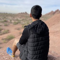
I was forced to go to Sears Kay Ruins for a work fieldtrip. I was convinced they were going to pull a Dwight Schrute and leave us out there and make us find our way back to the office. But, it ended up not being too bad! Not too many people know about the area, so it feels kind of cool to find something off the beaten path. The surroundings are gorgeous (as much as a desert can be). The rocks are a loose granite- so they looked different than most other hikes in the valley. A friend said, "Why are the rocks so... rocky?" ha! The "ruins" were just a bunch of rocks stacked in a 2 foot wall. It looked like there were a lot of short hiking trails to explore. There is a bathroom with toilet paper (it's kind of yucky, but if you have to go, it works). There are covered picnic tables with bbqs. It is all paved roads to get there (Pima north to Cave Creek east to Sears Kay Ruins Rd). I recommend having a full tank of gas to get there, and plenty of water and snacks.

4 months ago
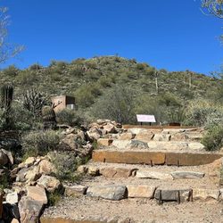
When driving around the area I came across these ruins. I decided to park and take the trek up to see the historical ruins at the top. The hike up to the top is easy (in my opinion), but there is a notable climb to the top which could be more of a moderate climb for some people. While there is an ADA parking spot, the hike itself isn't wheelchair accessible as there are no paved areas of the trail. Everyone's abilities vary but I wanted to provide that call out if there's anyone wondering about wheel chair accessibility. There are nice picnic areas and a restroom that are accessible for anyone using a wheelchair. There were some pretty flowers along the trail and the sights are beautiful. read more


a really cool spot to check out. It is not a long hike, but there is a bit of a vertical climb to get to the top. Nothing too crazy, just enough to get your legs working a little. At the top, you get to see what a small Hohokam outpost was like, which is pretty awesome. It is wild to think about people living up there and using that hill as a lookout and settlement area. You can still see the outlines of the old structures and get a real sense of the history. The views from the top are amazing too. You get a great look at the surrounding desert and mountains, which makes the climb totally worth it. If you are into local history or just want a short hike with a payoff at the top, Sears Kay Ruins is definitely worth the visit. read more


6 years ago
It's a nice little hike that's great for beginners. Once at the top you can see the beautiful Arizona desert scenery and oftentimes some wildlife. (As shown in the picture of the rock with the hawk or eagle on it and the photo with the circus grasshopper.) Reading about the history of the ruins and see the rock formations that have been there for many many years is moving. read more


8 years ago
16 years ago
I was forced to go to Sears Kay Ruins for a work fieldtrip. I was convinced they were going to pull a Dwight Schrute and leave us out there and make us find our way back to the office. But, it ended up not being too bad! Not too many people know about the area, so it feels kind of cool to find something off the beaten path. The surroundings are gorgeous (as much as a desert can be). The rocks are a loose granite- so they looked different than most other hikes in the valley. A friend said, "Why are the rocks so... rocky?" ha! The "ruins" were just a bunch of rocks stacked in a 2 foot wall. It looked like there were a lot of short hiking trails to explore. There is a bathroom with toilet paper (it's kind of yucky, but if you have to go, it works). There are covered picnic tables with bbqs. It is all paved roads to get there (Pima north to Cave Creek east to Sears Kay Ruins Rd). I recommend having a full tank of gas to get there, and plenty of water and snacks. read more


RUINS IN SCOTTSDALE "Well hell, these are ruins, boy!" said like Foghorn Leghorn https://www.youtube.com/watch?v=Gx98pskffOY Alright, well I wouldn't drive out of the way and be able to give this a five-star rating, but when you are out and about on a drive and happen along a little stop like this...well, that's road trip gold! In the Tonto National Forest, along the "Great Western Trail" - the 3000 mile backcountry route from Canada to Mexico: Add to it a "circus grasshopper" encountered on the path and sitting still while I clicked away on the photos....add to it a chorus of butterfly wings fluttering in the light breeze of this easy one mile hike as we made our way up...add it to the gorgeous 360 panaromic views on a beautiful Spring day in the Sonoran Desert...add it to yes, well there are scattered rocks aka "ruins" forming structures that are delineated in detailed signage...and add to it to this "tippy rock" that is a one-rock balancing act and you have an amazing little way to take in some history and to spend an hour in the fresh open air. The Hohokams were busy up here 900 years ago doing their thing. Not a lot is left of their civilization but enough to give you an idea and appreciation for the lay of the land. (The informational signs are quite detailed.) You also get the feeling you are "way out there" and I like thinking about that I'm pretty close to a major metropolis and this other realm sits quietly out here in the desert. Oh! and on the descent, perfectly-timed...add to it the "Harlequin moment" - like the cover of a novel - across the field a muscled and shirtless stranger in jeans, striding along in the warm sun...totally awesome "visual of life!" Even without the shirtless stranger, so picturesque here! Enjoy it for what it offers (free), totally off the beaten path, easy parking, one restroom facility, no water available...and you won't be disappointed. It's a solid four-star from me but this visit was a golden five. weblink: https://www.fs.usda.gov/recarea/tonto/recreation/outdoorlearning/recarea/?recid=35235&actid=119 read more


More info about Sears Kay Ruins
Ask the Community - Sears Kay Ruins


Sears Kay Ruins - hiking - Updated June 2026
Best of Scottsdale
People found Sears Kay Ruins by searching for…
Scenic Drive in Scottsdale, Arizona
Lookout Points in Scottsdale, Arizona
Picnic Spots in Scottsdale, Arizona
Things to Do in Scottsdale, Arizona
Sunrise Hike in Scottsdale, Arizona
Hiking Trails With Waterfalls in Scottsdale, Arizona
Sunrise View in Scottsdale, Arizona
Scenic Overlook in Scottsdale, Arizona
Paved Walking Trails in Scottsdale, Arizona
Fishing Spots in Scottsdale, Arizona
Off Road Trails in Scottsdale, Arizona
Photo Spots in Scottsdale, Arizona
Swimming Holes in Scottsdale, Arizona
Secret Spots in Scottsdale, Arizona
Scenic View in Scottsdale, Arizona
Hiking With Kids in Scottsdale, Arizona
Places to Take Pictures in Scottsdale, Arizona
Hiking Trails Kid Friendly in Scottsdale, Arizona
Picnic Areas in Scottsdale, Arizona
Trending Searches in Scottsdale, AZ
Bait And Tackle Shop near Sears Kay Ruins
Black Owned Nail Salons near Sears Kay Ruins
Boat Rental near Sears Kay Ruins
Cliff Jumping near Sears Kay Ruins
Day Trips near Sears Kay Ruins
Dog Friendly Trails near Sears Kay Ruins
Fishing Spots near Sears Kay Ruins
Jet Ski Rental near Sears Kay Ruins
Kayak Rental near Sears Kay Ruins
Lakes & Ponds near Sears Kay Ruins
Outdoor Activities near Sears Kay Ruins
Pick Your Own Farms near Sears Kay Ruins
Places To Walk Around near Sears Kay Ruins
Public Shower near Sears Kay Ruins
River Swimming near Sears Kay Ruins
Rock Quarry near Sears Kay Ruins
Scenic Night View near Sears Kay Ruins
Scenic Overlook near Sears Kay Ruins
Secluded Spots near Sears Kay Ruins
Soccer Store near Sears Kay Ruins
Splash Pad near Sears Kay Ruins
Strawberry Picking near Sears Kay Ruins
Sunrise View near Sears Kay Ruins
Swimming Holes near Sears Kay Ruins
Swimming Lakes near Sears Kay Ruins
Swimming Pools near Sears Kay Ruins
Watch Sunset near Sears Kay Ruins
Browse Nearby
Browse Brands
Related Searches in Scottsdale, AZ
Affordable Kayak Rental Services in Scottsdale, Arizona
Best Fishing Locations and Guides in Scottsdale, Arizona
Best Nature Trails for Hiking in Scottsdale, Arizona
Best Places for Horseback Riding in Scottsdale, Arizona
Best Waterfalls and Swimming Holes in Scottsdale, Arizona
Check Out Off Road Trails in Scottsdale, Arizona
Discover Dog Friendly Trails to Explore in Scottsdale, Arizona
Discover Scenic Mountain Bike Trails Near Scottsdale, Arizona
Discover Scenic Waterfall Spots in Scottsdale, Arizona
Discover Top Nature Parks to Visit in Scottsdale, Arizona
Discover Walking Parks in Scottsdale, Arizona Near You
Discover the Best Night Hike Trails in Scottsdale, Arizona
Discover the Best Running Track in Scottsdale, Arizona
Enjoy Camping Adventures Around Scottsdale, Arizona
Enjoy Exciting Mountain Biking Adventures in Scottsdale, Arizona
Enjoy Kayaking Adventures in Scottsdale, Arizona
Enjoy River Tubing Adventures in Scottsdale, Arizona
Enjoy Tent Camping Spots Around Scottsdale, Arizona
Enjoy a Beautiful Waterfall Hike in Scottsdale, Arizona
Enjoy the Best Walking Path in Scottsdale, Arizona
Enjoy the Best Walking Trails in Scottsdale, Arizona
Exciting Cliff Jumping Spots in Scottsdale, Arizona
Experience Thrilling White Water Rafting in Scottsdale, Arizona
Explore Beautiful Parks and Green Spaces in Scottsdale, Arizona
Explore Easy Hikes Perfect for All in Scottsdale, Arizona
Explore Fun Activities to Do in Scottsdale, Arizona
Explore Popular Campgrounds Near Scottsdale, Arizona
Explore the Best Beach Spots in Scottsdale, Arizona
Explore the Best Boating Spots in Scottsdale, Arizona
Explore the Best Trail Options in Scottsdale, Arizona
Family Friendly Hiking With Kids in Scottsdale, Arizona
Find Beautiful Views in Scottsdale, Arizona
Find Cozy Camping Cabins in Scottsdale, Arizona
Find the Best Parks for Picnics in Scottsdale, Arizona
Find the Best Scenic View Locations in Scottsdale, Arizona
Great Places to Walk in Scottsdale, Arizona
Hiking Trails With Waterfalls in Scottsdale, Arizona
Off Leash Dog Hiking Trails in Scottsdale, Arizona
Plan a Scenic Drive Route Near Scottsdale, Arizona
Popular Fishing Spots to Explore in Scottsdale, Arizona
Popular Outdoor Activities to Try in Scottsdale, Arizona
Popular Picnic Spots to Visit in Scottsdale, Arizona
Safe River Swimming Areas in Scottsdale, Arizona
Safe and Fun Parks for Kids in Scottsdale, Arizona
Top Climbing Spots and Gyms in Scottsdale, Arizona
Top Running Trails to Explore in Scottsdale, Arizona
Top Swimming Lakes to Enjoy in Scottsdale, Arizona
Top Swimming Spots and Pools in Scottsdale, Arizona