St Mary’s Peak Trailhead Photos


More like St Mary’s Peak Trailhead
Recommended Reviews - St Mary’s Peak Trailhead
Start your review...

24 days ago


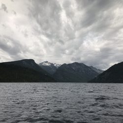
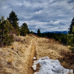
St. Mary Trailhead has adequate parking for both cars and trailers. It offers access to St. Mary Peak Trail #116, St. Mary Lookout and the Selway-Bitterroot Wilderness. Facilities include a vault toilet. The trail is a 7 miles moderate round trip with a little bit over 3,000 ft elevation gain to reach 9310 ft. Bring a bug spray if you hike it in the summer. read more


More info about St Mary’s Peak Trailhead


St Mary’s Peak Trailhead - hiking - Updated July 2026
Best of Stevensville
People found St Mary’s Peak Trailhead by searching for…
Things to Do in Stevensville, Montana
Hiking Trails in Stevensville, Montana
Beautiful Views in Stevensville, Montana
Easy Hikes in Stevensville, Montana
Waterfall Hike in Stevensville, Montana
Picnic Areas in Stevensville, Montana
Waterfalls in Stevensville, Montana
Trail in Stevensville, Montana
Walking Trails in Stevensville, Montana
Lakes & Ponds in Stevensville, Montana
Running Trails in Stevensville, Montana
Fun Things to Do at Night in Stevensville, Montana
Swimming in Stevensville, Montana
Tent Camping in Stevensville, Montana
Caves in Stevensville, Montana
Scenic View in Stevensville, Montana
Secret Spots in Stevensville, Montana
Places to Take Pictures in Stevensville, Montana
View Points in Stevensville, Montana
Things to Do on a Rainy Day in Stevensville, Montana
Tourist Attractions in Stevensville, Montana
Swimming Lakes in Stevensville, Montana
Trending Searches in Stevensville, MT
Browse Articles
Browse Brands
Related Searches in Stevensville, MT
Affordable Kayak Rental Services in Stevensville, Montana
Best Dog Hiking Trails Around Stevensville, Montana
Best Fishing Locations and Guides in Stevensville, Montana
Best Fun Things to Do in Stevensville, Montana
Best Places for Horseback Riding in Stevensville, Montana
Check Out Off Road Trails in Stevensville, Montana
Discover Kid Friendly Hiking Trails in Stevensville, Montana
Discover Top Boat Tours in Stevensville, Montana for All Ages
Discover a Hiking Trail in Stevensville, Montana
Discover the Best Night Hike Trails in Stevensville, Montana
Enjoy Camping Adventures Around Stevensville, Montana
Enjoy Kayaking Adventures in Stevensville, Montana
Enjoy Off Leash Dog Hikes in Stevensville, Montana
Enjoy River Tubing Adventures in Stevensville, Montana
Enjoy Tent Camping Spots Around Stevensville, Montana
Enjoy a Beautiful Waterfall Hike in Stevensville, Montana
Enjoy the Best Tubing Experiences in Stevensville, Montana
Experience Thrilling White Water Rafting in Stevensville, Montana
Explore Beautiful Parks and Green Spaces in Stevensville, Montana
Explore Bike Rentals Throughout Stevensville, Montana
Explore Easy Hikes Perfect for All in Stevensville, Montana
Explore Fun Activities to Do in Stevensville, Montana
Explore Popular Campgrounds Near Stevensville, Montana
Explore Popular RV Parks Around Stevensville, Montana
Explore Popular Scenic Overlook Points in Stevensville, Montana
Explore Popular Scenic Views Near Stevensville, Montana
Explore the Best Swimming Holes Around Stevensville, Montana
Family Friendly Hiking With Kids in Stevensville, Montana
Find Beautiful Views in Stevensville, Montana
Find Cozy Camping Cabins in Stevensville, Montana
Find Fun Things to Do With Kids in Stevensville, Montana
Find the Best Playgrounds to Visit in Stevensville, Montana
Hiking Trails With Waterfalls in Stevensville, Montana
Plan a Scenic Drive Route Near Stevensville, Montana
Popular Fishing Spots to Explore in Stevensville, Montana
Popular Outdoor Activities to Try in Stevensville, Montana
Popular Picnic Spots to Visit in Stevensville, Montana
Popular Things to Do in Stevensville, Montana
Relax at Natural Hot Springs Near Stevensville, Montana
Safe River Swimming Areas in Stevensville, Montana
Safe and Fun Parks for Kids in Stevensville, Montana
Top Hiking Trails to Explore in Stevensville, Montana
Top Paddleboarding Activities in Stevensville, Montana
Top Playgrounds for Kids to Enjoy in Stevensville, Montana
Top RV Campgrounds to Visit in Stevensville, Montana
Top Swimming Spots and Pools in Stevensville, Montana
People who viewed St Mary’s Peak Trailhead also viewed
Blodgett Canyon
6 reviews
Lee Metcalf National Wildlife Refuge
4 reviews
Bear Creek Overlook
3 reviews
Traveler's Rest State Park
7 reviews
Dunrovin Ranch
8 reviews
The Hamilton Trap Club
1 review
Trapper Peak Outfitters & Guest Lodge
2 reviews
Iron Horse Athletic Club
6 reviews
Whittecar Rifle & Pistle Range
6 reviews
Ranya Anabtawi - Empathic Yoga
41 reviews