Turtle Rock Viewpoint Trail Photos


You might also consider


More like Turtle Rock Viewpoint Trail
Recommended Reviews - Turtle Rock Viewpoint Trail
Start your review...


Reviews With Photos


Great trail to do a sunset hike. We did a leisurely 6-mile Loop. Great views out to the ocean. Please come and create your own adventure


This was a nice paved walk. to me, this was not a hike? I just felt we were in housing tracks so much it didn't feel like we got away or found that peace you do on a true hike. But it got the job done and we all have burnt some calories. I found other dog owners so respectful even if they had larger ones being cautious with there's around my little ones, very nice etiquette of fellow dog parents. Would come back though as a walk. Unless it brought us to the wrong location? If we ever find a different location I will update this.


It was a challenging trail that starts with a straight incline up a brushy hill then goes through an area behind houses, down to a steep decline to a street. Wear shoes with good traction and bring a lot of water and electrolytes. The trail takes about 2 hours or a little less depending on your pace. I'm not sure the viewpoint was worth it to be honest. Pretty.


Soooo I had to do some driving around to find the bottom trail head's. Most of them are in residential areas but I was not sure if it was a permit parking thing so until I have a better idea of where to park it will be 4 stars. I ended up parking at Chaparrel park. That entrance take you up a good set of cement stairs the. Gets you into the steepest point of the hike and to the highest vista point. It really is nice up there I can see this being amazing for sunset. I then did some scouting and took the trails down to find all the trail head entrances. 1- hike- the hike at the base going up is easy-moderate, if you enter from Chaparrel park.. you have a pretty good difficult steep hike then it kicks back in to moderate than easy.. in all honesty.. this is perfect for trail running with the pup.. 2- people - people for the most part were keeping their distance and wearing masks. It was not to heavy of traffic for a Sunday morning sooo I was pretty happy with it. 3- dog friendly-.. yes..... My dog does great off leash but I did keep him on leash on this run. He loved the hike and I'll definitely be doing it with him again. There are two places at the two points of the Vista that have trash cans.. PICK UP YOUR DOGS POOP... Be a responsible dog parent and pick up the poop... People run this trail and I dont want to step in it.. there are places to throw it away...put your big person pants on BAG IT , CARRY IT THEN TOSS IT IN THE BINS. Overall a good hike if I find a better place to park I'll post it.. be courteous to the neighborhood and to nature !! Cheers C-JAC


Great hiking spot especially during the pandemic. There is a lot of room for social distancing. The time I was there, there were both people who were masked and unmasked. Pros: - i used the AllTrails app for the route to follow. - There is plenty of parking in the residential area across from Turtle Rock Preschool. - Some uphills, but pleasant area Cons: - some people walk their dogs and refused to collect their dog poop. So there are a lot throughout the trail!


Easy loop. Used AllTrails app for directions. Started from Chapparal Park and parked in the residential area. Went up the stairs to the viewpoint. Such a pretty view of Irvine. I can see this trail being a hot spot for sunrises and sunsets. Looped around through the neighborhood.


"Getting to the top is optional. Getting down is mandatory." Ed Viesturs I enjoy that this hike is in Irvine and relatively local. There are tons of homes, so it's a big awkward to try to find the trail. It requires driving past people's neighborhoods in search for this local trail. When you get to the top it's beautiful. The hike itself is relatively paved. It's a pretty easy hike but parking can be a pain. Besides the homes/lights when you get up top, there isn't that much to see...I've been spoiled having hiked in various parts of true wilderness in Kansas, Utah, Korea, and Japan...so when I come here, I'm scaling/inflating it at 4/5 relative to southern California. My fellow comrads who are used to more strenuous and scenic routes in less city areas, please take that into account when considering this trail.


Used the trail from the All Trail App. It was a decent hike about 5 Miles. See my pictures for what the trail looks like, lots of good scenery and vegetation on the hike. But towards the end you end up walking through normal neighborhoods to get back to the cars. I'd recommend starting at the park at the bottom instead of parking on the random street it starts you at. There are multiple intersecting trails as well so you can explore and mix it up! Dog friendly trail, but please pick up your poop!


Beautiful view from top of the hill. The hike was short but steep, but that's just how I like. Such a nice hike/walk if you have little time after work, the View is nice and peaceful up there either for sunrise or sunrise or at night. But he cautious for little insects, especially after the rain. The flowers are blossoming, just keep your eyes on the road.


This is a fantastic hike. The views are super pretty especially during sunset. The incline is a little challenging for beginning hikers like me, but it is a lovely trail. Super beautiful nature in the middle of Irvine City


This is NOT a hike. More like a short walk up a hill in a suburban neighborhood. The "trail" starts at the rear of Chaparral Park (next to Bonita Elementary). The first part is all paved and mostly stairs. This provides some good cardio but about the time your heart really starts pumping you are done with the stairs. The second part is a loose dirt and rock trail to the top of the hill. From the start of the trail to the top of the hill only took me about 10-15 minutes and I'm not all that nimble. There is a great view of Irvine, Costa Mesa and Newport from the top. I continued to walk a trail along the ridge line of the hills but within a quarter mile it was heading back down into the neighborhood so I just turned around and went back. I did get a glimpse of a fairly substantial snake crossing the trail on top of the hill, probably 3 feet long. Not sure what type of snake it was but definitely not a rattlesnake. If you want a short walk and get a bit of cardio along with a great view, this is your baby but only worthwhile if you live in the area.
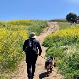

Fri late morning 4/2/21. Parking on the street was easy. We passed only a handful of people on the trail, including two dogs whose owners were considerate. This was an easy hike for Mason but there really wasn't any shade. I think we must not have followed the trail right because we found ourselves in the housing community. Or is this hike similar to Signal Hill and more of a steep walk through the neighborhood? We thoroughly enjoyed the tall grass and wildflowers with our wild and free GSD. It was a good workout with some steep pathways. I imagine this would be a great spot to see a sunset and city lights at night. But there was lots of broken glass at the top and an odd heap of stones. Doesn't look like it would be family friendly after dark. Maybe we will try this hike at another time and follow someone else's map.


17 years ago

15 years ago

13 years ago

12 years ago

11 years ago

11 years ago

10 years ago

14 years ago
9 years ago

12 years ago

13 years ago


13 years ago

12 years ago

14 years ago

10 years ago

14 years ago
12 years ago
9 years ago
11 years ago
8 years ago
12 years ago
11 years ago
10 years ago
More info about Turtle Rock Viewpoint Trail
Irvine, CA 92603
Directions
Hours
Indoor Amenities
Outdoor Amenities
Ask the Community - Turtle Rock Viewpoint Trail
Is there free parking?
Yes, parking is free. It's in a residential area so plenty of parking on the streets.
Can you park your car and look at the view from the car?
no you can't. need to hike up
Hi, is this trail good for a 6 and an 8 year old kid? Is there a way to circle back to the starting place without doing a path twice? We are looking for maybe 1-2 hours of light walk... thanks!!
Yes it's good for your kids if you only plan to stop at the stairs level, because there are some very steep and slippery rocks you need to climb if you want to get to the very top. The whole trail is very short; it takes about 1 hour at most, at…
Does anyone know the hours?
beginning in september 2018, the upper dirt trail closes from dusk to sunrise and is patrolled by the irvine police who will write citations for trespassing. the lower park area closes at 10 p.m.
Review Highlights - Turtle Rock Viewpoint Trail
You might also consider





















Why does Yelp recommend reviews?
15 reviews that are not currently recommended
The reviews below are not factored into the business's overall star rating.
13 years ago
11 years ago
17 years ago
8 years ago

11 years ago
3 years ago

13 years ago
15 years ago

14 years ago

13 years ago

11 years ago
13 years ago

15 years ago
7 years ago
Turtle Rock Viewpoint Trail - hiking - Updated September 2026
Best of Irvine
People found Turtle Rock Viewpoint Trail by searching for…
Trending Searches in Irvine, CA
Apple Orchards near Turtle Rock Viewpoint Trail
Apple Picking near Turtle Rock Viewpoint Trail
Barbers near Turtle Rock Viewpoint Trail
Bike Shop near Turtle Rock Viewpoint Trail
Bird Sanctuary near Turtle Rock Viewpoint Trail
Casinos near Turtle Rock Viewpoint Trail
Cliff Jumping near Turtle Rock Viewpoint Trail
Consignment Shops near Turtle Rock Viewpoint Trail
Cruising Spots near Turtle Rock Viewpoint Trail
Dog Friendly Things To Do near Turtle Rock Viewpoint Trail
Ear Piercing near Turtle Rock Viewpoint Trail
Eyebrow Threading near Turtle Rock Viewpoint Trail
Flower Fields near Turtle Rock Viewpoint Trail
Hair Braiding near Turtle Rock Viewpoint Trail
Kids Haircut near Turtle Rock Viewpoint Trail
Lakes near Turtle Rock Viewpoint Trail
Mens Haircut near Turtle Rock Viewpoint Trail
Parks near Turtle Rock Viewpoint Trail
Picnic Areas near Turtle Rock Viewpoint Trail
Preschools near Turtle Rock Viewpoint Trail
Public Golf Courses near Turtle Rock Viewpoint Trail
Rock Quarry near Turtle Rock Viewpoint Trail
Running Trails near Turtle Rock Viewpoint Trail
Scenic Night View near Turtle Rock Viewpoint Trail
Scenic Overlook near Turtle Rock Viewpoint Trail
Sunrise View near Turtle Rock Viewpoint Trail
Swimming Holes near Turtle Rock Viewpoint Trail
Trading Card Shops near Turtle Rock Viewpoint Trail
Browse Articles
Browse Nearby
BEST of Irvine, California Coffee near Turtle Rock Viewpoint Trail
BEST of Irvine, California Restaurants near Turtle Rock Viewpoint Trail
BEST of Irvine, California Things to Do near Turtle Rock Viewpoint Trail
BEST of Irvine, California Breakfast near Turtle Rock Viewpoint Trail
BEST of Irvine, California Walking Trails near Turtle Rock Viewpoint Trail
BEST of Irvine, California Parks near Turtle Rock Viewpoint Trail
BEST of Irvine, California Campgrounds near Turtle Rock Viewpoint Trail
BEST of Irvine, California Sightseeing near Turtle Rock Viewpoint Trail
BEST of Irvine, California Glamping near Turtle Rock Viewpoint Trail
Browse Brands
Related Searches in Irvine, CA
Affordable Kayak Rental Services in Irvine, California
Best Dog Hiking Trails Around Irvine, California
Best Fishing Locations and Guides in Irvine, California
Best Nature Trails for Hiking in Irvine, California
Best Places for Horseback Riding in Irvine, California
Check Out Off Road Trails in Irvine, California
Discover Dog Friendly Trails to Explore in Irvine, California
Discover Easy Hiking Trails Near Irvine, California
Discover Kid Friendly Hiking Trails in Irvine, California
Discover Popular Bike Trails in Irvine, California
Discover Scenic Mountain Bike Trails Near Irvine, California
Discover Walking Parks in Irvine, California Near You
Discover a Hiking Trail in Irvine, California
Discover the Best Night Hike Trails in Irvine, California
Dog-Friendly Hikes With Dogs in Irvine, California
Enjoy Camping Adventures Around Irvine, California
Enjoy Kayaking Adventures in Irvine, California
Enjoy Off Leash Dog Hikes in Irvine, California
Enjoy Scenic Places to Walk in Irvine, California
Enjoy Tent Camping Spots Around Irvine, California
Enjoy a Beautiful Waterfall Hike in Irvine, California
Enjoy the Best Walking Path in Irvine, California
Enjoy the Best Walking Trails in Irvine, California
Explore Beautiful Parks and Green Spaces in Irvine, California
Explore Easy Hikes Perfect for All in Irvine, California
Explore Popular Campgrounds Near Irvine, California
Explore Popular Dog Walking Trails in Irvine, California
Explore Top Dog Parks in Irvine, California Near You
Explore the Best Beach Spots in Irvine, California
Family Friendly Hiking With Kids in Irvine, California
Find Beautiful Views in Irvine, California
Find Parks and Recreation Activities in Irvine, California
Find Top Dog Friendly Parks to Visit in Irvine, California
Find the Best Parks for Picnics in Irvine, California
Find the Best Playgrounds to Visit in Irvine, California
Hiking Trails With Waterfalls in Irvine, California
Off Leash Dog Hiking Trails in Irvine, California
Popular Outdoor Activities to Try in Irvine, California
Popular Picnic Spots to Visit in Irvine, California
Popular Waterfall Hiking Trails in Irvine, California
Safe River Swimming Areas in Irvine, California
Safe and Fun Parks for Kids in Irvine, California
Top Hiking Trails to Explore in Irvine, California
Top Playgrounds for Kids to Enjoy in Irvine, California
Top Running Trails to Explore in Irvine, California
Top Swimming Lakes to Enjoy in Irvine, California
Top Swimming Spots and Pools in Irvine, California
Top-Rated Camping Sites in Irvine, California


