Peters Canyon Hike Photos


You might also consider
More like Peters Canyon Hike
Recommended Reviews - Peters Canyon Hike
Start your review...

Reviews With Photos


This park has amazing hikes, I did the entire park finally. Great views and friendly people. There is convenient parking with a $3.00 fee. There was this awesome girl who was leaving while I was driving in and she was super kind enough to give me her parking pass!! What a lovely person! Sorry for the horrible pictures :(


Always a nice peaceful everyday walk. Great to take dogs on the trail too. Swim steep hills going up or down on the orange entrance side and can be a bit slippery gravel. From end to end a good walk for about 5000-8000 steps. Lots of allergens for those that may break out in hives or sneezes as you get closer to the tustin side.


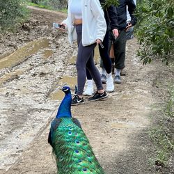
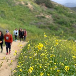
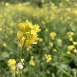
I've been hiking here for years and it's one of my favorite places to go. You can either park at the official "entrance" or down by the elementary school which is where most locals and myself enter the hike. Parking gets packed during peak hours like early morning or right before sunset so plan accordingly. I try to come here earlier in the day to avoid the summer heat -- keep in mind it starts getting hot and sunny around 10 am. There are several routes you can take that vary in difficulty. I find this to be a medium to difficult hike with a good amount of hills and steep inclines. Right now in the summer there's a lot of flys, the plants are dried out, and it's all sun on the trail. But don't let that discourage you! If you're looking to break a sweat and get a good workout in, just come early. During the spring this trail is so beautiful with greenery, flowers, and of course bees. It's also a dog friendly hike, just watch out for rattlesnakes and coyotes.

Peters Canyon has been a staple in the community. I have been going to hike here at least since 2010 and while some things have changed it remains clean and beautiful. This is a great beginner hike for someone who wants to just network the park. There's hills that get your blood pumping sprinkled around. Watch out for wildlife and be aware of your surroundings. After the heavy rains, Peter is as lush and beautiful as ever. Native Wildflowers are scattered about and the park is filled with color. After remodeling the side closer to the free street parking (I prefer the $paid$ lot), I think it has become way more baby stroller friendly. We use a BOB jogger all terrain pro and it handles this hike easy. This is an amazing hike.

Created a hiking group this New Years and this was our first hike of the year! We enjoyed over 5 miles of hiking, nature and trails! Dogs welcome too! Lots of different trails and loops. Many access points as well. Highly recommend for solo hikes or group hiking. There were even some bicycles on the trails. It was a great hike to start off the New Year! Will be back! Don't forget to pay for parking before you go. There are two pay stations available. Or get a parks pass from your local library!

It was Saturday around 530pm. Was planning to park on the south side but all the street parking was taken. Drove to the north side parking lot, plenty of parking and the machine said "$3 to park until 5pm" so I assume it's free after 5. Only had about an hour (before 8pm sunset) but it was enough to do a loop CCW around the reservoir. Trail was a mix of easy and moderate. Saw a lot of wild rabbits. I was pleasantly surprised by the variety of flowers and plants. It was pretty with the reservoir and sunset backdrop. Only came across 10 people, maybe because it was pretty late. Got back to the parking lot around 802pm and one gate was closed already. Saw the park ranger pulling up around 810pm so guessing he was closing the other gate shortly; there were still a few cars in the lot, wonder how long he sticks around. Nice evening, will check out the south side next time.

Peters Canyon Hike is a fun, easy local hike! It's near roads and homes so you don't feel so isolated and feel like you're in the depths of nature. I felt safe when I did quick solo hikes. My phone also never lost service so I was able to listen to music without any problem. Parking is $3 which I don't mind since it goes towards Peters Canyon! The parking pass is good for the whole day until closing. Actual restrooms are available by the parking lot which I thought were pretty clean. There are many different trail options with various levels of difficulty which you can enter pretty much anywhere from the parking lot. The pathways are labeled with difficulty level and arrows. It's pretty fun to go all different ways and see which path you end up on. Be prepared for dirt roads, some steep hills, possible mud if it rained, horse/dog poop and the sun shining! This hike is kid and dog friendly! Like I said, I've always felt safe here. There are always plenty of other hikers when I've gone. I have yet to encounter a wild animal. Poison oak signs and "stay on trail" signs are scattered throughout so you should obviously stay on the trail for your own safety.

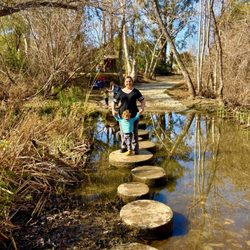
Nice hiking trail!! I would say it's fairly easy with two tough hills. I saw people running up them so it might just be me who is out of shape lol. The hike took us about 1 hr to complete. Saw some kids jumping into the water reservoir, saw some mountain bikers, lots of joggers, and bees! Careful for snakes! We didn't see any but there were a few signs. There is NO shade.. come prepared! Loved it

Definitely a strong 4.5 location. There's a north side with paid parking and a south side with street parking, with lower lake dr being a great location to park if the north is busy. Round trip from n to s can be around 4.5 miles to 5.5 miles. A variety of trails, inclines of 2° to around 15° rolling hills, long hill climbs, many rest area with benches and delightful picturesque sceneries. Great for bike riders, joggers runners hikes and walks. Pet friendly with leash and please bring comfortable workout shoes and water and clean up after yourself. Many small trails makes the adventure fun, exhaustive and complete. This trail can extend towards the north, Irvine park or to the south towards the river paths in Irvine. Whats missing is a park for the kids or possibly warer stations.... beyond that, a great place to chill out ... Get to it slow poke!


Great place for a hike. There is hardly any shade though so best to go early in the am, or early evening, or cloudy day. You will get a great workout. You can park at the start of the park where gps takes you or I start on the back side. You can go for 4mile along the top route &/or the hike around the lake. You choose. When there's rain, it's beautiful to see the surroundings. Otherwise, it's a little dry. I've seen it all. Been hiking this for year. SYOY! read more


Review 30/365 day challenge 2.04.26 Finally made it here to PC for a late morning hike w my hiking Gfren Pow. She's a regular here and been coming. Have told mee several times she loves this hike and it's a good hike where it's a bit more busier than other hiking trails that you feel safe to go to. Started the hike a little late morning around 11:15 a.m. and finished right before 12:40 p.m. A little over 4 miles. We went to a much easier hike trail. Where it was much shading area until you enter the hiking trail and then it was full of sun. Luckily it was a bit breezy so wasn't too fully hot. There's different areas to park, some where it's free of charge and they have the main parking where supposedly have av actual public restroom for $ 3. We parked near some residential area. Right before entering the entrance where the trail started, there was about 5 porter potties available. As all hikes there are warning signs of Rattlesnakes, poison ivy, mountain lions etc. Located in Tustin borderline of Orange. Not too far from Irvine Regional park off Jamboree. Will definitely return to hike here and check out the different trails. read more


One of my favorite hikes that I've been doing since I was in high school! This past weekend, I went on a hike at Peters Canyon, and specific did the Peter Canyon Trail to East Ridge View Trail to Eucalyptus Spur Trail, totally about 4ish miles. This trail had a few hills that weren't too steep. It's a busier hike, so even though we arrived at 8am, there were tons of people already and it's dog-friendly, so you'll see plenty of furry friends along the way! One of my favorite things about this hike is how well-marked everything is. Our hike started by the South entrance, which really only offers limited street parking, and looped towards the lake and back before hitting the lake. It was fairly shaded, and gets really sunny when you begin climbing the hills. It took us about 2ish hours to complete the whole hike, and overall it was enjoyable! There are bathrooms at the south entrance, so definitely use it before hiking because there won't be any other for a while. read more

3 months ago
9 months ago
One of my favorite places to go hiking and just walking around. The paths are wide and there are many different paths to choose from with shade. read more


2 years ago
This park has amazing hikes, I did the entire park finally. Great views and friendly people. There is convenient parking with a $3.00 fee. There was this awesome girl who was leaving while I was driving in and she was super kind enough to give me her parking pass!! What a lovely person! Sorry for the horrible pictures :( read more


Great spot for a relaxing hike! Brought my dog, and there was plenty of space to walk and explore. The trail is huge with nice views, and I liked that there were different difficulty levels to choose from. A really peaceful place to get outside and enjoy nature!! read more


1 year ago
Always a nice peaceful everyday walk. Great to take dogs on the trail too. Swim steep hills going up or down on the orange entrance side and can be a bit slippery gravel. From end to end a good walk for about 5000-8000 steps. Lots of allergens for those that may break out in hives or sneezes as you get closer to the tustin side. read more


4 months ago
1 year ago
Hike was great. Great place to walk around and hang out pretty cool place to chill and walk read more

I've been hiking here for years and it's one of my favorite places to go. You can either park at the official "entrance" or down by the elementary school which is where most locals and myself enter the hike. Parking gets packed during peak hours like early morning or right before sunset so plan accordingly. I try to come here earlier in the day to avoid the summer heat -- keep in mind it starts getting hot and sunny around 10 am. There are several routes you can take that vary in difficulty. I find this to be a medium to difficult hike with a good amount of hills and steep inclines. Right now in the summer there's a lot of flys, the plants are dried out, and it's all sun on the trail. But don't let that discourage you! If you're looking to break a sweat and get a good workout in, just come early. During the spring this trail is so beautiful with greenery, flowers, and of course bees. It's also a dog friendly hike, just watch out for rattlesnakes and coyotes. read more


Peters Canyon has been a staple in the community. I have been going to hike here at least since 2010 and while some things have changed it remains clean and beautiful. This is a great beginner hike for someone who wants to just network the park. There's hills that get your blood pumping sprinkled around. Watch out for wildlife and be aware of your surroundings. After the heavy rains, Peter is as lush and beautiful as ever. Native Wildflowers are scattered about and the park is filled with color. After remodeling the side closer to the free street parking (I prefer the $paid$ lot), I think it has become way more baby stroller friendly. We use a BOB jogger all terrain pro and it handles this hike easy. This is an amazing hike. read more


Created a hiking group this New Years and this was our first hike of the year! We enjoyed over 5 miles of hiking, nature and trails! Dogs welcome too! Lots of different trails and loops. Many access points as well. Highly recommend for solo hikes or group hiking. There were even some bicycles on the trails. It was a great hike to start off the New Year! Will be back! Don't forget to pay for parking before you go. There are two pay stations available. Or get a parks pass from your local library! read more


2 years ago
It was Saturday around 530pm. Was planning to park on the south side but all the street parking was taken. Drove to the north side parking lot, plenty of parking and the machine said "$3 to park until 5pm" so I assume it's free after 5. Only had about an hour (before 8pm sunset) but it was enough to do a loop CCW around the reservoir. Trail was a mix of easy and moderate. Saw a lot of wild rabbits. I was pleasantly surprised by the variety of flowers and plants. It was pretty with the reservoir and sunset backdrop. Only came across 10 people, maybe because it was pretty late. Got back to the parking lot around 802pm and one gate was closed already. Saw the park ranger pulling up around 810pm so guessing he was closing the other gate shortly; there were still a few cars in the lot, wonder how long he sticks around. Nice evening, will check out the south side next time. read more

Peters Canyon Hike is a fun, easy local hike! It's near roads and homes so you don't feel so isolated and feel like you're in the depths of nature. I felt safe when I did quick solo hikes. My phone also never lost service so I was able to listen to music without any problem. Parking is $3 which I don't mind since it goes towards Peters Canyon! The parking pass is good for the whole day until closing. Actual restrooms are available by the parking lot which I thought were pretty clean. There are many different trail options with various levels of difficulty which you can enter pretty much anywhere from the parking lot. The pathways are labeled with difficulty level and arrows. It's pretty fun to go all different ways and see which path you end up on. Be prepared for dirt roads, some steep hills, possible mud if it rained, horse/dog poop and the sun shining! This hike is kid and dog friendly! Like I said, I've always felt safe here. There are always plenty of other hikers when I've gone. I have yet to encounter a wild animal. Poison oak signs and "stay on trail" signs are scattered throughout so you should obviously stay on the trail for your own safety. read more


Nice hiking trail!! I would say it's fairly easy with two tough hills. I saw people running up them so it might just be me who is out of shape lol. The hike took us about 1 hr to complete. Saw some kids jumping into the water reservoir, saw some mountain bikers, lots of joggers, and bees! Careful for snakes! We didn't see any but there were a few signs. There is NO shade.. come prepared! Loved it read more


2 years ago
Definitely a strong 4.5 location. There's a north side with paid parking and a south side with street parking, with lower lake dr being a great location to park if the north is busy. Round trip from n to s can be around 4.5 miles to 5.5 miles. A variety of trails, inclines of 2° to around 15° rolling hills, long hill climbs, many rest area with benches and delightful picturesque sceneries. Great for bike riders, joggers runners hikes and walks. Pet friendly with leash and please bring comfortable workout shoes and water and clean up after yourself. Many small trails makes the adventure fun, exhaustive and complete. This trail can extend towards the north, Irvine park or to the south towards the river paths in Irvine. Whats missing is a park for the kids or possibly warer stations.... beyond that, a great place to chill out ... Get to it slow poke! read more


Great hiking spot with entrances in both Tustin and Orange. Tustin has free parking and Orange has a pay kiosk lot. There are paths, hills, and lots of photo op spots. Dogs, horses, bikes, and walkers all share the paths together. read more


This is a great 6 mile hike that's not super difficult but has some incline/decline. Plenty of flowers in the spring and pretty scenic areas. Followed someone's yelp post here and you can get free parking on the street routing to the location Q64H+RJH, Tustin, CA. There is also a parking lot with bathrooms but I believe they charge a small amount. Some porta potties in the middle as well. read more


First tip -- google "Peters Canyon Hike" and not Peters Canyon Regional park for the entrance to this moderate to difficult trail located in Tustin / Irvine. The full loop (taking the difficult route) runs about 4mi and just a touch under 600ft elevation. WEAR YOUR SUNSCREEN! There is a slightly easier route (moderate) but by the time you get to the decision point, you would have done most of the ascent already -- and captured all the views! The elevation gain is quite rapid as the last (or first, if you start the loop this way) 1.5mi or so of the hike is practically flat, so the full 600ft is gained in just a 2.5mi trek. There are some shaded spots at the beginning and end, but for the most part, this hike is WIDE OPEN and in direct sunlight as you swing up and down the hills, ogling the neighborhood's wonderful homes. What a dream it would be to live in this area -- the roads are so well-maintained. This trail has been a staple of mine for a few years now, and parking is not the worst you'll see in LA / OC. Can't wait to come back here for a workout again soon! read more


 - Hiking Near Me - Tustin, California")

I've been here many times over the years and consider it a solid local hike. Lots of different trails with lake views, city views and creek views, with varying levels of difficulty. You can spend 45 minutes - 1 hour getting a quick hike in, or take a stroll over several hours exploring the park. There are a few fairly steep hills (one in particular) that can solidify you getting in an intense workout. Trails are dog friendly, populated sparsely with poop bags and trash cans throughout. Parking is $3 in the lot, or free on the street if you enter from the back side. Be sure to bring lots of water as there is very little shade. Enjoy! read more


2 years ago
5 years ago
You would never expect what this hidden gem has to offer considering it's in the middle of a random, secluded neighborhood in Tustin. Street parking is available but when I went it was so packed that I parked in the elementary school's lot considering they weren't in session at 4 pm, of course (do be careful because you may get towed!!) This hike is pretty much modifiable to your liking, length wise & intensity- flat ground vs hills. I started where the portable bathrooms were shortly after entering the park. Personally, I love hiking so I ran on the "East Ridge trail" that included the lake view loop which turned out to be about 5 miles of moderate intensity. There are plenty of inclines to conquer that I saw tons of people just continuously going back and forth on, so definitely a great full body workout. On the top of each hill, there's usually a "break area" with benches to chill on and gorgeous views to take in. Do be aware that there's barely any shade anywhere so you are indeed going to get a good dose of Vitamin D for the day - don't forget to stay hydrated & apply that SPF! This trail is both dog & family friendly, as well so I really loved it. read more


I've been a few times now and it's a easy/moderate hike with a few hills that are pretty close together and a good sized incline, nice views and everyone on the trail is pretty nice. Parking is $3 in the lot and there's usually plenty of parking. They close the lot at sunset or 8:30 p.m. in the summer time. A few of the trails they have closed off due to habitat restoration. I find this hike to be quick, challenging and peaceful. The only issue I came across were the restrooms were locked when I've tried using them and I'm not sure if that's because it's after 5 p.m. on a weekday. Other than that, great local hike if you live in the area and don't want to drive too far. read more

2 years ago
This is one of my favorite hiking trails in Orange County. Parking is never a problem, it's close enough to civilization while still feeling the wonder of nature and you get a great workout. While I've never seen snakes or other animals, do be weary that you might come across a coyote or something unless you are there during peak time on the weekends because it gets busy. I usually do the 5 mile loop and it's a great workout that will not take you all day. read more

The Peters Canyon Lake View Trail was a ~6 mile loop with a few steep inclines & declines. Not too many great views except for the reservoir somewhere at the last 1 mile before heading back to the parking lot. Main parking lot seems to fill up pretty quick otherwise you can try to find free street parking at nearby residential area. There were A LOT of people at this place on Sunday morning. Probably 50% of the people were not wearing any masks. Not really any shades either so expect to bake in the sun. Overall, this trail was a good workout and I can see why a lot of people come here. read more


Came here yesterday afternoon because it was such a beautiful day to be outside..$3 to pay to park, the restrooms were clean, the trails were just as neat as I remembered them to be. Wish there was less dog poop along the north loop. We wore some weighted vests and woke up sore the next day. Overall, my fiancé and I had a great time. I'd recommend this trail to friends and family. read more


Very steep trail terrain a bit challenging but these are the best from experience. There is hardly no shade through out this trail Sunblock Water Comfortable shoes is a highly recommended! There is a fee you have to pay if you park in the front entrance. Going before 11 is the best personal, if you decide to do the whole thing. I did use the app AllTrails it helps guide you to complete the trail correctly I always had trouble finding a way to complete this particular trail read more


3 years ago
This is a good beginning hike that's about 6 miles more or less depending on whether you go to the Tustin or Orange entrance. My friends and I followed the directions through AllTrails to the Orange location, which led us to a parking lot that also had bathrooms and picnic tables available. There's a parking attendant that helps guides hikers to their parking spots. However, after further reading, the Tustin location actually has free parking whereas, Orange . Few inclines and some declines. Lots of birds, snails, and some animals. Trail is shared with hikers, bikers, and horse riders. Definitely an enjoyable hike! read more


6 years ago
Family friendly loop with rolling hills. Came here and did a ~5 mile loop on a Saturday. It's a pretty popular trail even during covid. The trail is exposed so bring lots of water, or come earlier in the day. Leashed dogs are allowed. It's an equestrian trail as well, so be mindful of the horse poop! It's fine if you wear sneakers, although hiking boots wouldn't hurt when you're going downhill, as some of the parts are sandy. The trail is pretty wide, and there's plenty of options to take different directions if you're inclined to explore. There is a sulphuric smell close to the lake, so that was the only unpleasant thing about the hike. Parking is $3 and you'll pay at the machine. Bathrooms (both porta-potty and regular) are available at the entrance. There's a lot spots available; it would be difficult to find street parking since the neighborhood posted signs indicate that permits are needed. Overall, it's a good spot for people of all fitness levels. read more


7 years ago
One of my favorite places that's local when I'm back in Irvine to go hiking. I would go here with my mom early morning (at around 6:30 to 7 am) but it's not that early because side parkings are usually filled and everyone is already hiking or going to go hiking. I find it surprising that people are parking on the side because the signs show you can only park 30 mins starting at 7 am but I've seen cars that's been there for over 30 mins. Anyways, it gets a bit crowded and a bit noisy when there are crowds but it's still a nice hike up on the hills/mountains. To get to the peak, it took us 45 minutes which was an elevation of 564 feet! It's a great walk/hike but when you get there when the sun rises, it gets pretty hot so it's better if you can get there before the sun is up. It does have some steep hills but it's great! But it was a nice 4 mile walk from the beginning all the way to the top and back. If you like hiking and want something easy, I highly recommend this place but just beware of parking. read more

4 years ago
Great place to hike. It can be challenging, especially if you choose the ridge route, but the scenery is worth it. Bring water and understand it can get very hot on the trail. Lots of people on the weekends so just be aware of that. It is better during the week. Park at the south end, on the street, for free. read more


3 years ago
Beautiful, moderate, safe hike. Hills give a good workout! Go now while the wildflowers are still blooming! read more


This park is beautiful during spring/summer. The park itself branches into different trails so grab a map to avoid going in circles. The Peters canyon trail isn't too challenging.. until you reach that steep hill lol. The view isn't WOW but the wildflowers make up for it. Look where you're stepping because there's animal poo. Parking gets crowded especially during weekend mornings and the fee is $3. read more

3 years ago
One of the best places to hike in Orange County. I found this place on my lunch and decided to come on a weekend. It is the perfect place to run, hike, walk your dog, and burn 500 kcals after a big meal! Plus it kind of looks like Italy from the top read more


5 years ago
Loved this hike! This was my first time here and I came with a friend. There is a paid parking lot (dirt) but people are often giving each other the tickets to reuse and not pay for. This was what happened to us when we came. We started on the Lakeview trail which was pleasant and made our way to other numerous trails. I wish the trails had signs for difficulty level, but I did not notice this. Perhaps it is best to use a trail app on your phone. I liked the views with plenty of canyons and wildlife. I felt like there were plenty of options to explore and come back and do different hikes as well. I would recommend wearing good shoes as some parts are filled with stones and you do not want to slip based on your footing. There are also clean restrooms available by the parking lot which was very convenient. I did about 6 miles here and left pleased. read more

Page 1 of 10
More info about Peters Canyon Hike
26981 Peters Canyon Rd
Tustin, CA 92782
Directions
Hours
Indoor Amenities
Outdoor Amenities
Peters Canyon Hike Reviews in Other Languages
Ask the Community - Peters Canyon Hike
Is the parking lot closed? If so, where do you park?
The parking lot is located at 8548 Canyon View Ave, Orange, CA 92869.
Are the trail closed right now due to the pandemic?
It was closed the first week this thing started but there was still a lot of people. I went last weekend and they opened it up again.
Is there any shade along the trails or you're always under the sun?
Not along the trails. There's a few spots before/after big red (depending on which way ur coming from)
Has anyone backpacked this loop? I want to take my kids for an overnight but can't find any campsite info.
The park closes at sunset. Not aware of anyone camping in the area. I would not suggest camping there, no camp sites and a natural wildlife habitat. Many coyotes, snakes, raccoons, bobcats etc. I would suggest to check (www.alltrails.com) for more… Read more
Do you knw if they close at a certain hour? can you go any time during the day?
7am to Sunset. When walking back in the dark make sure you have a flashlight. People typically use there cell phone as a light but make sure it is charged.
How do you find which trail is the easy trail? Is it clearly marked?
The trails are marked but unsure which is an easy trail. I would always suggest to start at the South Entrance (Tustin). On the way back you can cut down and take the flat way back which is much easier versus the same hillside you went up. I would… Read more
Are there any snakes or dangerous animals along the trail?
No. I haven't come across anything dangerous, and I hike here pretty often. You will see warning signs of rattle snakes, but don't worry. Enjoy and have fun exploring!
How long is the hike?
The hike up to the top and back down takes me maybe an hour, at most? There are a lot of detours on the hike to shorten it, but I take the main route and it's usually about an hour with a few stops. There are also plenty of ways to extend your… Read more
Review Highlights - Peters Canyon Hike
You might also consider


Why does Yelp recommend reviews?
15 reviews that are not currently recommended
The reviews below are not factored into the business's overall star rating.
1 year ago
14 years ago
11 years ago
9 years ago
14 years ago
7 years ago
11 years ago
13 years ago
14 years ago
6 years ago
7 years ago
13 years ago
12 years ago
13 years ago
Peters Canyon Hike - hiking - Updated June 2026
Best of Tustin
People found Peters Canyon Hike by searching for…
Hiking Trails in Tustin, California
Dog Friendly Things to Do in Tustin, California
Things to Do in Tustin, California
Waterfall Hike in Tustin, California
Sunrise View in Tustin, California
Running Trails in Tustin, California
Scenic View in Tustin, California
Walking Trails in Tustin, California
Sunset View in Tustin, California
Off Road Trails in Tustin, California
Scenic Drive in Tustin, California
Stairs Workout in Tustin, California
Dog Friendly Hiking Trails in Tustin, California
Night Hiking in Tustin, California
Watch Sunset in Tustin, California
Flower Field in Tustin, California
Shaded Hike in Tustin, California
Stroller Friendly Hikes in Tustin, California
River Swimming in Tustin, California
Trending Searches in Tustin, CA
Black Owned Nail Salons near Peters Canyon Hike
Boat Rental near Peters Canyon Hike
Cliff Jumping near Peters Canyon Hike
Day Trips near Peters Canyon Hike
Dog Friendly Things To Do near Peters Canyon Hike
Fishing Spots near Peters Canyon Hike
Jet Ski Rental near Peters Canyon Hike
Kayak Rental near Peters Canyon Hike
Lakes & Ponds near Peters Canyon Hike
Outdoor Activities near Peters Canyon Hike
Parks For Picnics near Peters Canyon Hike
Pick Your Own Farms near Peters Canyon Hike
Places To Walk Around near Peters Canyon Hike
Public Shower near Peters Canyon Hike
River Swimming near Peters Canyon Hike
Rock Quarry near Peters Canyon Hike
Scenic Night View near Peters Canyon Hike
Scenic Overlook near Peters Canyon Hike
Secluded Spots near Peters Canyon Hike
Soccer Store near Peters Canyon Hike
Splash Pad near Peters Canyon Hike
Strawberry Picking near Peters Canyon Hike
Sunrise View near Peters Canyon Hike
Swimming Holes near Peters Canyon Hike
Swimming Lakes near Peters Canyon Hike
Watch Sunset near Peters Canyon Hike
Browse Articles
Browse Nearby
BEST of Tustin, California Coffee near Peters Canyon Hike
BEST of Tustin, California Things to Do near Peters Canyon Hike
BEST of Tustin, California Restaurants near Peters Canyon Hike
BEST of Tustin, California Walking Trails near Peters Canyon Hike
BEST of Tustin, California Parks near Peters Canyon Hike
BEST of Tustin, California Breakfast near Peters Canyon Hike
BEST of Tustin, California Campgrounds near Peters Canyon Hike
Browse Brands
Related Searches in Tustin, CA
Affordable Kayak Rental Services in Tustin, California
Best Fishing Locations and Guides in Tustin, California
Best Nature Trails for Hiking in Tustin, California
Best Places for Horseback Riding in Tustin, California
Check Out Off Road Trails in Tustin, California
Discover Dog Friendly Trails to Explore in Tustin, California
Discover Kid Friendly Hiking Trails in Tustin, California
Discover Scenic Hiking Trails in Tustin, California
Discover Scenic Mountain Bike Trails Near Tustin, California
Discover Scenic Waterfall Spots in Tustin, California
Discover Top Nature Parks to Visit in Tustin, California
Discover Walking Parks in Tustin, California Near You
Discover a Hiking Trail in Tustin, California
Discover the Best Night Hike Trails in Tustin, California
Dog-Friendly Hikes With Dogs in Tustin, California
Enjoy Camping Adventures Around Tustin, California
Enjoy Exciting Mountain Biking Adventures in Tustin, California
Enjoy Kayaking Adventures in Tustin, California
Enjoy Tent Camping Spots Around Tustin, California
Enjoy a Beautiful Waterfall Hike in Tustin, California
Enjoy a Peaceful Nature Walk in Tustin, California
Enjoy the Best Walking Path in Tustin, California
Enjoy the Best Walking Trails in Tustin, California
Exciting Cliff Jumping Spots in Tustin, California
Explore Beautiful Parks and Green Spaces in Tustin, California
Explore Easy Hikes Perfect for All in Tustin, California
Explore Popular Campgrounds Near Tustin, California
Explore the Best Beach Spots in Tustin, California
Explore the Best Swimming Holes Around Tustin, California
Explore the Best Trail Options in Tustin, California
Family Friendly Hiking With Kids in Tustin, California
Find Beautiful Views in Tustin, California
Find the Best Parks for Picnics in Tustin, California
Find the Best Scenic View Locations in Tustin, California
Great Places to Walk in Tustin, California
Hike the Popular Waterfall Trail in Tustin, California
Hiking Trails With Waterfalls in Tustin, California
Off Leash Dog Hiking Trails in Tustin, California
Plan a Scenic Drive Route Near Tustin, California
Popular Outdoor Activities to Try in Tustin, California
Popular Picnic Spots to Visit in Tustin, California
Safe River Swimming Areas in Tustin, California
Safe and Fun Parks for Kids in Tustin, California
Top Climbing Spots and Gyms in Tustin, California
Top Paddleboarding Activities in Tustin, California
Top Running Trails to Explore in Tustin, California
Top Swimming Lakes to Enjoy in Tustin, California
Top Swimming Spots and Pools in Tustin, California
People who viewed Peters Canyon Hike also viewed
Turtle Rock Viewpoint Trail
144 reviews
Santiago Oaks Regional Park
353 reviews
Orchard Hills Trail
5 reviews
Santiago Creek Trail
7 reviews
Santiago Creek Bike Trail
29 reviews
Upper Newport Wilderness Preserve
34 reviews
Quail Trail
7 reviews
Mountains To Sea Trail
8 reviews
French Hill
8 reviews
Coastal Peak Park
29 reviews