Twin Valley Horse Ranch
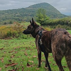
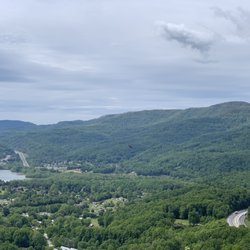
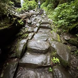
Twin Valley Horse Ranch Photos


You might also consider
More like Twin Valley Horse Ranch
Recommended Reviews - Twin Valley Horse Ranch
Start your review...

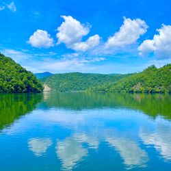
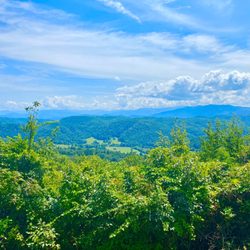
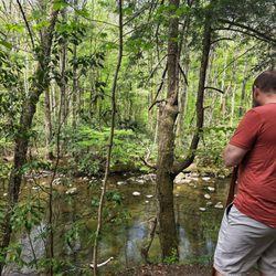
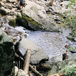
Reviews With Photos

my boyfriend and i went here for a trail ride and it was definitely the best trail riding experience i've ever had. it was a little bit more expensive than the typical ride but it was definitely worth it because it's such a long ride and you actually get to take care of your horse and learn some riding basics. the woman who owns the ranch is very kind and welcoming, and had lots of great stories to tell. she let us walk around the property and see all of her animals and it was just an overall great experience. i would definitely recommend going here if you're in the area and looking for a good trail ride adventure

1 month ago


4 years ago
The horses seemed tired. I was watching the first group leave as we got there. As they were walking, I seen the horses "knees" shake and looked painful for them to walk. My horse seemed to have something wrong with its mouth. When we mounted, my horse was chewing on the bridle angrily. The guide instructed me not to pull on the reigns, but my horse kept getting to close to my daughters horse in front of me and making my daughters horse kick mine. I had no choice but to pull on the reigns a bit. The guide did say they have days off. But from what I've seen, they seemed tired and in pain. Their manes were full of tangles and burs. The trail was beautiful. read more


2 years ago
I left my heart in Tennessee when I first visited Twin Valley Ranch! Literally! It's a magical place, just a slice of heaven with all the animals and the cheerful cowboy spirit! Not only that, we ended up buying a property across the street and now own our own slice of heaven! Janice is a great teacher about horses and all the animals, Jadyn is a seasoned guide on trail rides and horses in the ring and kids connect with both quickly. My grandkids keep crying wanting to visit her ranch again... every time they visit Tennessee they are welcomed there! read more


2 years ago
5 years ago
my boyfriend and i went here for a trail ride and it was definitely the best trail riding experience i've ever had. it was a little bit more expensive than the typical ride but it was definitely worth it because it's such a long ride and you actually get to take care of your horse and learn some riding basics. the woman who owns the ranch is very kind and welcoming, and had lots of great stories to tell. she let us walk around the property and see all of her animals and it was just an overall great experience. i would definitely recommend going here if you're in the area and looking for a good trail ride adventure read more


6 years ago
5 years ago
5 years ago
My husband and I came to Knoxville, TN for a long weekend to unwind from...LIFE. I work with Thoroughbreds and I love my job so it takes a lot for me to take off of work and go on vacation. One thing I knew I wanted to do was ride horses with my husband in Tennessee because who wouldn't?! I searched many different trail riding stables and stumbled upon Twin Valley Horse Ranch. The photos looked a bit quirky with the old Western type theme, so I knew what I was potentially getting into, but we gave it a go. We were booked for the 9am trail ride and they offered us to come early to help with the horses and feed the other farm animals. When we showed up, Marcus greeted us and we groomed some of the horses and helped feed the chickens, rabbits, and cats. Jayden showed us around and was very informative! Once we went back to our horses to start the trail ride, we went over some rules for safety and education. We had a mother and daughter join us on our trail ride. Once we were all up on our horses we got to know our horses and Janice went over some tips for a successful and safe ride. She lead the way with the mother and daughter behind her, and Jayden lead my husband and me. She was pointing out all of the plants and old buildings and history facts about them. We went down into creeks, up hills, and did some trotting and cantering! It was so much fun to see my husband enjoying horses as much as I do! At the end of our ride we helped in tack and turned the horses out in their paddocks. The views were beautiful and felt very safe and trusted our horses and tour guides the whole time! It was an absolute blast and we will tell all of our friends about Twin Valley Horse Ranch! Highly recommend this experience for both experienced riders and inexperienced riders! The passion for horses is evident in all of the employees!! 10/10! read more


More info about Twin Valley Horse Ranch
2848 Old Chilhowee Rd
Walland, TN 37886
Directions
(865) 984-0980
Call Now
Visit Website
http://www.twinvalleyhorseranch.com
Hours
Payment methods
Outdoor Amenities
Other Amenities
From the Business
Ask the Community - Twin Valley Horse Ranch
Do you allow families to do trail rides that are not staying on the premises? We live in Maryville, and we'd love to give our TX grandkids this great experience when they come to visit.
hello! YES< we love to share our place with local folks. You just have to call ahead and make reservations. As far ahead as possible b/c many of our guests book horses the… Read more
You might also consider


Why does Yelp recommend reviews?
1 review that is not currently recommended
The reviews below are not factored into the business's overall star rating.
5 years ago
Twin Valley Horse Ranch - horsebackriding - Updated June 2026
Best of Walland
People found Twin Valley Horse Ranch by searching for…
Things to Do in Walland, Tennessee
Scenic View in Walland, Tennessee
Horse Boarding in Walland, Tennessee
Bed & Breakfast in Walland, Tennessee
Scenic Overlook in Walland, Tennessee
Hiking Trails in Walland, Tennessee
Playgrounds in Walland, Tennessee
Hot Springs in Walland, Tennessee
Swimming Lakes in Walland, Tennessee
Running Trails in Walland, Tennessee
Off Road Trails in Walland, Tennessee
Fun Things to Do at Night in Walland, Tennessee
Apartments in Walland, Tennessee
Picnic Areas in Walland, Tennessee
Waterfall in Walland, Tennessee
Mountain Biking in Walland, Tennessee
Trending Searches in Walland, TN
Bait And Tackle Shop near Twin Valley Horse Ranch
Boat Rental near Twin Valley Horse Ranch
Cliff Jumping near Twin Valley Horse Ranch
Day Trips near Twin Valley Horse Ranch
Dog Friendly Trails near Twin Valley Horse Ranch
Dog Swimming near Twin Valley Horse Ranch
Fishing Spots near Twin Valley Horse Ranch
Hotels & Travel near Twin Valley Horse Ranch
Jet Ski Rental near Twin Valley Horse Ranch
Kayak Rental near Twin Valley Horse Ranch
Lakes & Ponds near Twin Valley Horse Ranch
Lodging near Twin Valley Horse Ranch
Monthly Rates Motel near Twin Valley Horse Ranch
Natural Hot Springs near Twin Valley Horse Ranch
Pick Your Own Farms near Twin Valley Horse Ranch
Public Shower near Twin Valley Horse Ranch
River Swimming near Twin Valley Horse Ranch
Scenic Overlook near Twin Valley Horse Ranch
Splash Pad near Twin Valley Horse Ranch
Strawberry Picking near Twin Valley Horse Ranch
Sunrise View near Twin Valley Horse Ranch
Swimming Holes near Twin Valley Horse Ranch
Swimming Lakes near Twin Valley Horse Ranch
Swimming Pools near Twin Valley Horse Ranch
Vacation Rentals near Twin Valley Horse Ranch
Browse Articles
Browse Nearby
Browse Brands
Related Cost Guides
Related Searches in Walland, TN
Affordable Corporate Housing Options in Walland, Tennessee
Affordable Lodging Options in Walland, Tennessee
Affordable Long Term RV Parking in Walland, Tennessee
Best Fishing Locations and Guides in Walland, Tennessee
Best Lookout Points to Visit in Walland, Tennessee
Best Places for Horseback Riding in Walland, Tennessee
Best Spots for Star Gazing in Walland, Tennessee
Best Things to Do on a Rainy Day in Walland, Tennessee
Book Dog Friendly Hotels in Walland, Tennessee
Book a Romantic Honeymoon Suite in Walland, Tennessee
Browse Charming Cabins in Walland, Tennessee
Browse Top Hotels in Walland, Tennessee for Your Stay
Browse Top Wedding Venues in Walland, Tennessee
Browse the Best Casinos Located in Walland, Tennessee
Check Out Off Road Trails in Walland, Tennessee
Connect With Vacation Rental Agents in Walland, Tennessee
Discover Dog Friendly Trails to Explore in Walland, Tennessee
Discover Fun Farms for Kids in Walland, Tennessee
Discover Horseback Riding Tours in Walland, Tennessee
Discover Popular Bike Trails in Walland, Tennessee
Discover Popular Photo Spots in Walland, Tennessee
Discover Scenic Mountain Bike Trails Near Walland, Tennessee
Discover Stunning Skyline View Spots in Walland, Tennessee
Discover Top Nature Parks to Visit in Walland, Tennessee
Discover a Hiking Trail in Walland, Tennessee
Discover the Best Night Hike Trails in Walland, Tennessee
Discover the Best Running Track in Walland, Tennessee
Dog-Friendly Hikes With Dogs in Walland, Tennessee
Effective Stairs Workout Spots in Walland, Tennessee
Enjoy Arts & Entertainment in Walland, Tennessee
Enjoy Camping Adventures Around Walland, Tennessee
Enjoy Exciting Mountain Biking Adventures in Walland, Tennessee
Enjoy Hiking Adventures in Walland, Tennessee
Enjoy Relaxing Goat Yoga Classes in Walland, Tennessee
Enjoy Scenic Night View Experiences in Walland, Tennessee
Enjoy Stables and Horse Riding Experiences in Walland, Tennessee
Enjoy a Relaxing Bed & Breakfast Experience in Walland, Tennessee
Enjoy the Best Mini Golf Courses in Walland, Tennessee
Enjoy the Best Night View Spots in Walland, Tennessee
Enjoy the Best Tubing Experiences in Walland, Tennessee
Enjoy the Best Walking Trails in Walland, Tennessee
Exciting Cliff Jumping Spots in Walland, Tennessee
Experience Stunning Sunset Views in Walland, Tennessee
Experience Top Dressage Events in Walland, Tennessee
Expert Property Management Solutions in Walland, Tennessee
Explore Beautiful Parks and Green Spaces in Walland, Tennessee
Explore Beautiful Ranches to Visit in Walland, Tennessee
Explore Commercial Real Estate Opportunities in Walland, Tennessee
People who viewed Twin Valley Horse Ranch also viewed
Davy Crockett Riding Stables
51 reviews
Five Oaks Riding Stables
69 reviews
Cades Cove Campground Store and Bike Rental
36 reviews
Big Rock Dude Ranch at Ponderosa
146 reviews
Sugarlands Riding Stable
134 reviews
Goldrush Stables & Stage Lines
34 reviews
Goldrush Stables
3 reviews
Foxfire Mountain Adventure Park
111 reviews
Ridge Riders Adventure Rentals
30 reviews
Smoky Mountain Zipline
82 reviews