Vineyard Park Photos


You might also consider
More like Vineyard Park
Recommended Reviews - Vineyard Park
Start your review...

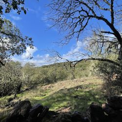
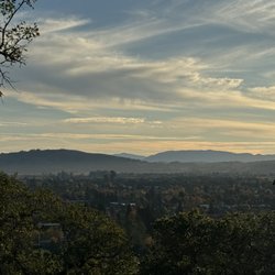
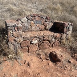
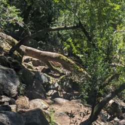
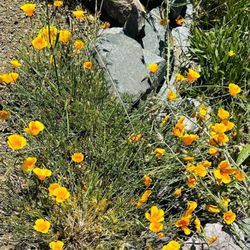
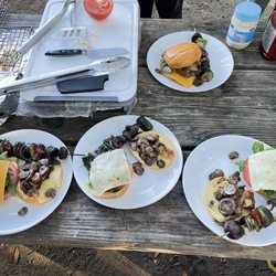
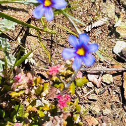
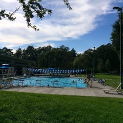
It really comes as no surprise to see that there is a park in this town called Vineyard Park. At the far end of this public park, you'll find most of the amenities such as an outdoor workout space, ping-pong table, four Pickleball courts and a tennis court. You'll also find a public bathroom, pic nic tables, half court and a grill along with a water fountain. On the opposite side of the street, you'll find a nice paved walking trail that runs along the rear of some nice residential homes. The only problem is, is that the pathway is part of a homeowners association, making it a private walkway. However, on the Park side, there is a paved path that leads to another picnic area facing the mountains and a vineyard just a few dozen feet away. If you're in Yountville, you may wish to explore this park for your own amusement and the 10 photos included might help get you here. read more


More info about Vineyard Park
You might also consider


Vineyard Park - parks - Updated June 2026
Best of Yountville
People found Vineyard Park by searching for…
Pickleball Courts in Yountville, California
Tennis in Yountville, California
Walking Trails in Yountville, California
Tennis Courts in Yountville, California
Hiking Trails in Yountville, California
Picnic Spots in Yountville, California
Basketball Courts in Yountville, California
Beautiful Views in Yountville, California
Things to Do in Yountville, California
Picnic Areas in Yountville, California
River Swimming in Yountville, California
Scenic Drive in Yountville, California
Easy Hikes in Yountville, California
Ping Pong Table in Yountville, California
Outdoor Exercise Parks in Yountville, California
Running Trails in Yountville, California
Places to Take Pictures in Yountville, California
Fall Foliage in Yountville, California
Photo Spots in Yountville, California
Fun Things to Do at Night in Yountville, California
Calisthenics Park in Yountville, California
Scenic View in Yountville, California
Trending Searches in Yountville, CA
Baseball Fields near Vineyard Park
Bird Sanctuary near Vineyard Park
Black Owned Nail Salons near Vineyard Park
Boat Rental near Vineyard Park
Cliff Jumping near Vineyard Park
Dog Friendly Beaches near Vineyard Park
Fishing Spots near Vineyard Park
Free Kids Activities near Vineyard Park
Free Picnic Areas near Vineyard Park
Jet Ski Rental near Vineyard Park
Kids Activities Outdoor near Vineyard Park
Lakes & Ponds near Vineyard Park
Off Road Trails near Vineyard Park
Outdoor Activities near Vineyard Park
Outdoor Basketball Courts near Vineyard Park
Paddle Boat Rentals near Vineyard Park
Parks With Pull Up Bars near Vineyard Park
Pick Your Own Farms near Vineyard Park
Places To Walk Around near Vineyard Park
Public Beaches near Vineyard Park
Public Shower near Vineyard Park
Rock Quarry near Vineyard Park
Scenic Drive near Vineyard Park
Scenic Night View near Vineyard Park
Secluded Spots near Vineyard Park
Soccer Store near Vineyard Park
Strawberry Picking near Vineyard Park
Sunrise View near Vineyard Park
Swimming Holes near Vineyard Park
Swimming Lakes near Vineyard Park
Swimming Pools near Vineyard Park
Watch Sunset near Vineyard Park
Browse Nearby
BEST of Yountville, California Coffee near Vineyard Park
BEST of Yountville, California Restaurants near Vineyard Park
BEST of Yountville, California Things to Do near Vineyard Park
BEST of Yountville, California Playgrounds near Vineyard Park
BEST of Yountville, California Breakfast near Vineyard Park
BEST of Yountville, California Picnic Areas near Vineyard Park
BEST of Yountville, California Campgrounds near Vineyard Park
BEST of Yountville, California Star Gazing near Vineyard Park
BEST of Yountville, California Natural Hot Springs near Vineyard Park
Browse Brands
Related Searches in Yountville, CA
Affordable Kayak Rental Services in Yountville, California
Best Fishing Locations and Guides in Yountville, California
Best Off Leash Dog Parks in Yountville, California
Best Parks for Parties and Events in Yountville, California
Best Places for Horseback Riding in Yountville, California
Best Water Parks for Kids in Yountville, California
Check Out Great Playgrounds in Yountville, California
Check Out Off Road Trails in Yountville, California
Discover Baseball Fields Around Yountville, California
Discover Beautiful Garden Spots in Yountville, California
Discover Dog Friendly Trails to Explore in Yountville, California
Discover Free Parking Options in Yountville, California
Discover Fun Toddler Parks in Yountville, California for Your Little One
Discover Kid Friendly Hiking Trails in Yountville, California
Discover Lakes & Ponds to Explore in Yountville, California
Discover Popular Photo Spots in Yountville, California
Discover Public Beaches to Visit in Yountville, California
Discover Scenic Bike Paths in Yountville, California
Discover Scenic Mountain Bike Trails Near Yountville, California
Discover Scenic Waterfall Spots in Yountville, California
Discover Soccer Fields in Yountville, California Near You
Discover Top Nature Parks to Visit in Yountville, California
Discover Top State Parks to Visit in Yountville, California
Discover a Hiking Trail in Yountville, California
Discover the Best Beaches in Yountville, California
Discover the Best Kids Park Spots in Yountville, California
Discover the Best Night Hike Trails in Yountville, California
Discover the Best Running Track in Yountville, California
Dog-Friendly Hikes With Dogs in Yountville, California
Enjoy Camping Adventures Around Yountville, California
Enjoy Exciting Mountain Biking Adventures in Yountville, California
Enjoy Kayaking Adventures in Yountville, California
Enjoy Scenic Places to Walk in Yountville, California
Enjoy Tent Camping Spots Around Yountville, California
Enjoy a Beautiful Waterfall Hike in Yountville, California
Enjoy the Best Picnic Spots and Ideas in Yountville, California
Enjoy the Best Walking Path in Yountville, California
Enjoy the Best Walking Trails in Yountville, California
Exciting Cliff Jumping Spots in Yountville, California
Experience Thrilling White Water Rafting in Yountville, California
Explore Beautiful Parks and Green Spaces in Yountville, California
Explore Easy Hikes Perfect for All in Yountville, California
Explore Family-Friendly Zoos and Wildlife in Yountville, California
Explore Free Picnic Areas Around Yountville, California
Explore Fun Activities to Do in Yountville, California
Explore Parks With Pull Up Bars in Yountville, California
Explore Popular Campgrounds Near Yountville, California
Explore Popular Picnic Areas Around Yountville, California