Wheeler Peak Photos


You might also consider
More like Wheeler Peak
Recommended Reviews - Wheeler Peak
Start your review...

Reviews With Photos
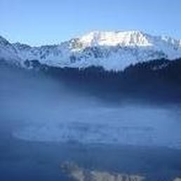
Activity Type: Hiking Nearby City: Taos Length: 15 totalmiles Elevation Gain: 3,771 feet Trail Type: Out-and-back Skill Level: Strenuous Duration: Day hike or overnight Season: June through October Trailhead Elevation: 9,390 feet Top Elevation: 13,161 feet Wheeler Peak lies in the center of the small 19,000-acre Wheeler Peak Wilderness. Several other of New Mexico's highest peaks lie in and around the wilderness. The peaks and ridges are one of the few areas in New Mexico with extensive amounts of alpine tundra vegetation. The glacial cirques on the slopes of the peaks contain many natural alpine lakes. Snowfields remain year round. Be sure to get a very early start on this hike. To minimize problems with storms, you ideally want to be on the summit before noon. Snow flurries are possible even in mid-summer. Be sure to take rain gear and extra warm clothing. Lightning and hypothermia are real threats on Wheeler Peak and the exposed summit ridge. Special attractions: Alpine terrain; tremendous views from New Mexico's highest peak.

10 months ago


6 years ago
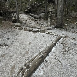
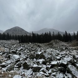
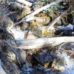
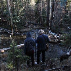
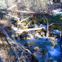
I spent a summer in the New Mexico high country years ago, and while I did my fair share of hiking that summer, I never took on Wheeler Peak, the highest point in New Mexico at just over 13,100 feet. I always figured I'd return to the area at some point, and maybe do the hike. Well, "some point" finally arrived, and I decided that I was going to make a serious effort at hiking this rather daunting-looking rocky, steep mountain. I gave myself permission to fail - while over the years I've probably spent far more time at altitude than 99.9% of South Floridians, the fact remains that I have spent most of my life at oxygen-rich sea level. I didn't practice for this. My existing fitness would either allow me to make it, or fail me. There are two main ways to get up the mountain, a longer, less steep 8 mile trail, and a shorter but steeper trail at just over 4 miles, known as the Williams Lake trail. I chose Williams Lake. The trailhead starts near the famous Bavarian restaurant within the Taos ski area. You basically take the road to the ski area, drive past it and find a dirt road. 2 miles up this dirt road and you'll find the trailhead parking lot. You can't miss it. I started my hike around 7:45AM. It is highly recommended to start early, as the weather above tree line is unpredictable and can change on a dime. You do NOT want to be stuck up there as an afternoon thunderstorm builds up in a matter of minutes. It is an exposed high alpine summit, subject to all the same potential extreme weather conditions of most high exposed summits. To me this hike can be broken down into 3 sections: 1) base at the Bavarian restaurant through the woods up to Williams Lake, about 2 miles, 2) Williams Lake up through ever sparser trees to tree line, about three-quarters of a mile, and 3) tree line to summit, traversing several rocky scree/talus slopes on the way, about a mile and a half. The first section up to Williams Lake is a nice hike in itself, and a popular day hike for families. It is a steady climb and not easy, and will be a challenge to inexperienced hikers, but most should be able to make it if they persevere. The payoff is a pretty high alpine lake situated in a picturesque bowl at about 11,000 feet with higher peaks on all sides. From there, part 2 gets you through sparse trees up to tree line. While not much more difficult than the first part, it was here when it became pretty apparent that every step was taking me to less oxygen. I was still strong at this point, but when you emerge in the meadows above tree line, you can see the peak and it looks way up there. In practical terms, from here you still have to climb a little higher than the Empire State Building, over the course of a mile and a half. At altitude. Above tree line. This is where it gets steeper, and rockier, as you traverse some loose talus slopes. It starts out fairly mild but ramps up fast. At this point, every step was difficult....I felt like Frodo taking the Ring to Mount Doom. It would have been very easy to quit. Some people did. It can be done though. One step at a time, keep drinking your water and you'll eventually make it. Keep an eye out for some fat marmots and bighorn sheep! Eventually you come to a staggeringly high saddle/ridgeline. From here, make a right and continue up the steep rocky slope....the payoff is only a few minutes away. Such amazing views, Wheeler Peak feels like the top of the world. What a feeling, to have walked and earned this view on the strength of your two legs. Now, after the adrenaline rush of reaching the summit, you have to descend. Pay attention. Cardio isn't a problem going down, but everything else is. Thighs burn like crazy. Lots of loose rock to slip on and hurt yourself. This was the most stunning hike I've ever done. If you think you can deal with a tough high altitude hike, I highly recommend it. read more


It's New Mexico's hat! (below is a description of the shortest, steepest route the summit: the "Williams Lake" trail) This hike gains about 3,000 ft over about 4 miles (8 miles RT). If you're a fast, experienced hiker, it could take 3-4 hours. If you're not, expect 7-8. The trail is incredibly well graded, meaning: there isn't any scrambling, you'll never really need to use your hands. There are some switchbacks that go through scree (rocks) so a trekking pole would be helpful. We saw tons of adorably, chubby marmots above the treeline. I'm not sure how much they paid them to pose for us, but it was worth it. Great views from the summit, of course. It's nice to be able to get to 13,000+ ft above sea level by simply walking. We did it in the afternoon, and summit'd just before sunrise. Highly recommended if you don't mind hiking out by headlamp! read more


Activity Type: Hiking Nearby City: Taos Length: 15 totalmiles Elevation Gain: 3,771 feet Trail Type: Out-and-back Skill Level: Strenuous Duration: Day hike or overnight Season: June through October Trailhead Elevation: 9,390 feet Top Elevation: 13,161 feet Wheeler Peak lies in the center of the small 19,000-acre Wheeler Peak Wilderness. Several other of New Mexico's highest peaks lie in and around the wilderness. The peaks and ridges are one of the few areas in New Mexico with extensive amounts of alpine tundra vegetation. The glacial cirques on the slopes of the peaks contain many natural alpine lakes. Snowfields remain year round. Be sure to get a very early start on this hike. To minimize problems with storms, you ideally want to be on the summit before noon. Snow flurries are possible even in mid-summer. Be sure to take rain gear and extra warm clothing. Lightning and hypothermia are real threats on Wheeler Peak and the exposed summit ridge. Special attractions: Alpine terrain; tremendous views from New Mexico's highest peak. read more


9 years ago
My daughter and I took the Williams Lake Trail to Wheeler Peak at 13,161 foot elevation on a family vacation several years ago. This is a well maintained trail with some amazing views. You are likely to see wildlife anywhere along the trail. We did this day hike in July so you will need to bring a rain poncho just in case of summer storms popping up. The round trip distance is about 8 miles total. If you go at a moderate pace and take time at the Lake and more time at the Peak you can count on about 8 hours for the entire trip. The elevation gain is about 3,700 foot. The temps on the mountain were in the 50's but we did have some strong winds that day once we got close to the top. Winds were gusting up to 30 mph. At over 11,000 foot elevation the winds are cold even when it is sunny. You loose the tree line after 12,000 foot so the rest of the hike leaves you exposed to the winds with no cover. The afternoon chances of rain go way up so be ready in case it rains on you. Being even a little wet at this elevation can be very bad news and deadly. The view at Williams Lake is really nice. As you ascend the mountain you will be able to look back down on the lake for some awesome views also. You really do need some high top boots with ankle support for hiking this trail as it has lots of loose rock that you will cross over several times on the mountain. That being said it is great trip to take the family and friends on. This is the highest mountain peak in the state of New Mexico. Take a daypack with snacks and water for the trip. Be sure to wear shades and a hat to protect your eyes. A windbreaker jacket will come in handy for sure. It is a Strenuous Hike for sure so be ready for it !! Enjoy the amazing wide open views at the peak !! Here is the youtube video of the push to the summit ..... https://www.youtube.com/watch?v=e5-yhqjFiEI read more


10 years ago
8 years ago
More info about Wheeler Peak
Ask the Community - Wheeler Peak


Wheeler Peak - hiking - Updated June 2026
Best of Taos Ski Valley
People found Wheeler Peak by searching for…
Lakes in Taos Ski Valley, New Mexico
Things to Do in Taos Ski Valley, New Mexico
Attractions in Taos Ski Valley, New Mexico
Hiking Trails in Taos Ski Valley, New Mexico
Natural Hot Springs in Taos Ski Valley, New Mexico
Easy Hikes in Taos Ski Valley, New Mexico
Sunset View in Taos Ski Valley, New Mexico
Off Road Trails in Taos Ski Valley, New Mexico
Hiking With Kids in Taos Ski Valley, New Mexico
Photo Spots in Taos Ski Valley, New Mexico
Beautiful Views in Taos Ski Valley, New Mexico
Walking Trails in Taos Ski Valley, New Mexico
Places to Take Pictures in Taos Ski Valley, New Mexico
Playgrounds for Kids in Taos Ski Valley, New Mexico
Scenic View in Taos Ski Valley, New Mexico
Fishing Spots in Taos Ski Valley, New Mexico
Running Trails in Taos Ski Valley, New Mexico
Sunrise View in Taos Ski Valley, New Mexico
Playgrounds in Taos Ski Valley, New Mexico
Free Campgrounds in Taos Ski Valley, New Mexico
View Points in Taos Ski Valley, New Mexico
Lakes & Ponds in Taos Ski Valley, New Mexico
Trending Searches in Taos Ski Valley, NM
Browse Articles
Browse Brands
Related Searches in Taos Ski Valley, NM
Best Fishing Locations and Guides in Taos Ski Valley, New Mexico
Best Lookout Points to Visit in Taos Ski Valley, New Mexico
Best Nature Trails for Hiking in Taos Ski Valley, New Mexico
Best Places for Stunning Views in Taos Ski Valley, New Mexico
Best Sledding Spots and Fun in Taos Ski Valley, New Mexico
Best Spots for Star Gazing in Taos Ski Valley, New Mexico
Discover Scenic Mountain Bike Trails Near Taos Ski Valley, New Mexico
Discover Top Nature Parks to Visit in Taos Ski Valley, New Mexico
Discover a Hiking Trail in Taos Ski Valley, New Mexico
Discover the Best Night Hike Trails in Taos Ski Valley, New Mexico
Dog-Friendly Hikes With Dogs in Taos Ski Valley, New Mexico
Enjoy Camping Adventures Around Taos Ski Valley, New Mexico
Enjoy Exciting Mountain Biking Adventures in Taos Ski Valley, New Mexico
Enjoy the Best Family Activities in Taos Ski Valley, New Mexico
Enjoy the Best Night View Spots in Taos Ski Valley, New Mexico
Enjoy the Best Picnic Spots and Ideas in Taos Ski Valley, New Mexico
Enjoy the Best Walking Trails in Taos Ski Valley, New Mexico
Experience Stunning Sunset Views in Taos Ski Valley, New Mexico
Explore Bike Rentals Throughout Taos Ski Valley, New Mexico
Explore Easy Hikes Perfect for All in Taos Ski Valley, New Mexico
Explore Free Picnic Areas Around Taos Ski Valley, New Mexico
Explore Fun Activities to Do in Taos Ski Valley, New Mexico
Explore Nature Spots Around Taos Ski Valley, New Mexico
Explore Popular Campgrounds Near Taos Ski Valley, New Mexico
Explore Popular RV Parks Around Taos Ski Valley, New Mexico
Explore Popular Scenic Overlook Points in Taos Ski Valley, New Mexico
Explore Popular View Points Around Taos Ski Valley, New Mexico
Explore Scenic Lakes to Visit in Taos Ski Valley, New Mexico
Explore Secret Spots Worth Visiting in Taos Ski Valley, New Mexico
Explore Top Water Parks in Taos Ski Valley, New Mexico Today
Explore the Best Trail Options in Taos Ski Valley, New Mexico
Explore the Scenic River in Taos Ski Valley, New Mexico
Family Friendly Hiking With Kids in Taos Ski Valley, New Mexico
Find the Best Scenic View Locations in Taos Ski Valley, New Mexico
Off Leash Dog Hiking Trails in Taos Ski Valley, New Mexico
Plan Nature Center Visits in Taos Ski Valley, New Mexico
Plan a Scenic Drive Route Near Taos Ski Valley, New Mexico
Popular Places to Take Pictures in Taos Ski Valley, New Mexico
Popular Things to Do in Taos Ski Valley, New Mexico
Popular Things to See in Taos Ski Valley, New Mexico
Relax at Natural Hot Springs Near Taos Ski Valley, New Mexico
Safe and Fun Parks for Kids in Taos Ski Valley, New Mexico
Top Paddleboarding Activities in Taos Ski Valley, New Mexico
Top Things to Do With Kids in Taos Ski Valley, New Mexico
Uncover the Best Secluded Spots Around Taos Ski Valley, New Mexico
People who viewed Wheeler Peak also viewed
Rio Grande Gorge Bridge
144 reviews
Goose Lake Trail
2 reviews
Los Rios River Runners
114 reviews
Monte Verde Lake Office
2 reviews
Orilla Verde Recreation Area
1 review
Black Rock Hot Springs Trail
1 review
Bobcat Pass Wilderness Adventures
56 reviews
Roadrunner Tours
105 reviews
Eagle Nest Marina
5 reviews
$$$$
Taos Ski Valley Village
18 reviews