Briones Regional Park Photos


You might also consider
More like Briones Regional Park
Recommended Reviews - Briones Regional Park
Start your review...

Reviews With Photos

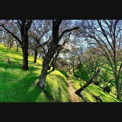
Briones Regional Park has a lot of different trails that you can walk on with a lot of spectacular views! There is plenty of parking, especially the earlier you go. There is lots of open space and there is not a lot of people on the trails. The trails are well maintained and this place has trails with varying levels of difficulty and distance. You can really soak in all the beauty of nature around you here, which is one of the many things I love about this place. The grass is really green during the beginning of the year until around April or May, which adds to the beauty. I find this place very peaceful and serene. There are a lot of beautiful rolling hills and many of the trails are at a steady incline, which adds to the beautiful views you see that overlook Martinez and the Diablo Valley! There are benches along the way for you to take some time for yourself and this is also a great place to go for a picnic. There are cows in the field at certain times of the year as well as people horseback riding on the trails at times. The trails can be a little narrow at times. For this reason, it is important that you watch your step while hiking so that you don't step in poop and give horses a lot of room so they don't get spooked. I would suggest wearing layers when you go hiking as well as wearing sunscreen. The higher you hike up the less shaded areas you will find. It is also good to bring plenty of water. There is a bathroom next to where you park that is always open that you can use before you start your hike.

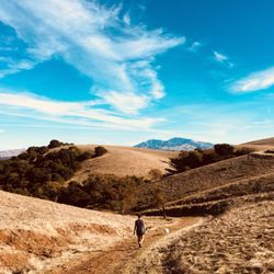
Oh Briones, you are stunning! Not a whole lot to add that hasn't been said about Briones. Beautiful, peaceful, miles and miles of hiking. You don't have to be totally in shape, I am so not. I mean it would help. Not gonna lie. But, everyone can enjoy their time here. I mean you don't have to walk far to be completely surrounded by some of the most beautiful scenery in the bay! Definitely recommend!


Amid the expanse of rolling brown hills we discovered two lagoons, one still filled with water despite the long, hot summer. And ... surprise! A lone cow had found her way through the gate into the enclosed oasis and was happily munching her way through a buffet of tall grasses growing in the water. And then we spotted a tiny movement near her deep within the lush surroundings ....

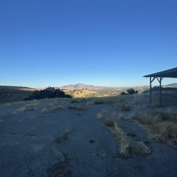
Allow me to take you on an adventure. I promise you that there will be action, horror, suspense, danger, mystery, comedy and escapade. Prior to adopting Jaime, our Australian Kelpie, and after losing Maxie, our beloved Yellow Labrador Retriever, I found myself doing a lot of solo hikes. I guess it was my coping mechanism and grieving process. I did bring Maxie's urn with me, so in a way, she was always with me. I've had this on my radar for a while and I finally came here on my day off. My navigation system took me to a side parking lot, and I could tell it wasn't the main lot. There were just a couple of cars parked in a dirt lot and saw a sign and a paved trail so off the trail I went. I should've read the sign first as I headed right when I passed a mini bridge and up a slight hill. I saw some houses and quickly determined that they are all abandoned, which gave me a spooky feeling. I kept going up until the path just went around in circle and I ended up right where I started from. As I was passing all those abandoned houses, I got goosebumps and couldn't shake that fact that someone or something was watching me. Every time I go on solo hikes, I'd always have my bolo knife with me and my sturdy hiking stick just in case. (Check out the video of the of the Utah hiker who was stalked by a mountain lion: https://youtu.be/j0ovbHmOMs0 ) Suddenly, I heard rustling and loud thumps and they got closer and closer. Then I spotted them....3 huge, majestic-looking deers staring right at me. I paused as they stopped in their tracks as they could probably smell me. Then they started stomping their hooves and the I could feel their power as it reverberated on the ground. I told 'em they didn't have to worry about me as I backed away with an elevated heartbeat and heightened senses. I went back down where I came from and decided to read the map so I'd know where to go. I took a left, which I should've done in the beginning, and the paved path ended and became a dirt trail. I went through the back of a neighborhood area and it veered uphill to get my blood pumping and the juices flowing. I kept following the trail as it meandered up and down until I finally reached a couple of gates and an open space clearing. There's a sign posted at the gates that I was entering a cow-grazing area and please to make sure to close the gate behind. It's a good thing I took a photo of the sign and read it. This is foreboding. After going through the second gate, it was a nice clearing and I saw how expansive this park was. The rolling hills looked so picturesque as I strolled up another hill to get a 360 degree view. I took some photos, but they don't do it justice to how beautiful the place looked in person. It's something that you must really see with the naked eye. It was in April of 2019, so the grass was green and lush, and a smell of fresh air and cow manure. There weren't too many people here at that time as I could make out a small group of hikers in the distance and a couple of people on horseback, but there were far and few in between. I kept following this trail for about a mile or so, until I reached another parking area complete with picnic tables. This must be the main parking lot so I turned around and took a lower trail to head back. In the middle of the trail was a nice tree and I decided to stop here and had a snack underneath the nice shade and breeze that it provided. Ahead of this trail, I noticed a pack of cows in front of me and I didn't pay them no mind initially. As I was packing up and getting ready to go, I noticed that one of the cows, a big bull, was in the middle of the trail. This bull was snorting and thumping his right hoof, similar to what the deer was doing earlier, but this mofo is a lot bigger and could do some serious damage to me. This scared the heck out of me as it obviously wanted me to move and didn't want me there in his path. As it lunged forward, I bolted up the side of the hill to get away from them. It was approximately 20 - 30 yards away and I was hauling my ass up that hill as quickly as I could. I stopped as I got up high enough and saw his group pass underneath me. But they all stopped in the area I was at a began grazing there. I guess I was at their favorite buffet area. This gave me a shot of adrenaline though and I could me heartbeat was still beating fast. Weary, I stayed on top of the hill as I continued to slowly walk back on the side of the hill, which was a challenge due to the fact that the ground wasn't even and full of holes from the tracks of the cows. Approximately 80 yards after the cows were behind, I decided to head back down the main trail. I finally calmed down once I reached the gate knowing I was safe, and I gave my self a good laugh and a huge sigh of relief. I've been here a couple of times since, but didn't have quite the adventure as my first. But there will be plenty more to come as I bring Jaime along with me. #YelpChallenge2020 review No. 19
We are so privileged to have so many East Bay regional parks in such close proximity. Briones is one of the larger ones and you can start from different staging areas from Martinez, Pleasant Hill or Lafayette. On these trails you'll find plenty of wild life including cows and coyotes. Some areas have steep inclines and not a lot of shade so it's best to come earlier in the day or closer to closing to avoid the heat in the summer. With different starting points, there's a little something for everyone. Definitely check this place out as it's one of the more popular East Bay Regional Parks in Contra Costa.

** The following review reflects my hiking experience prior to the shelter-in-place order currently in effect. ** As the COVID-19 pandemic surges, public officials have had to make the difficult decision to shut down certain parks that continued to draw congregations of people. Toward that end, the Bear Creek staging area has been closed, and even though I entered at the end of Springhill Road, I can see why they would need to start closing the parking lots to avoid overcrowding in neighborhoods already challenged by density and capacity in our new six-foot-apart world. Hard times still ahead of us as I consider myself lucky to discover this area just before the pandemic engulfed us all. Same as the Lake Chabot Loop (review: https://bit.ly/2UOOOso), I came upon the Briones Crest Loop Trail from a Thrillist article entitled "The East Bay's Most Incredible Hikes". I can see why it made the cut, but be forewarned that there is a lot of elevation variation involved. In fact, it was a lot like being on an endless elliptical screen with no steaming video screen option and on this late afternoon, a big fan blowing on you that you can't unplug. Even dealing with nature at its most blustery, the experience was enthralling with panoramic views at most every turn. When I was there, I ran into people walking in the opposite direction only twice because you have to have a certain stamina to trod these gravel trails. They were in their 70's. I have to admit I got confused by some of the forks along the way when the signage raised more questions than answered them. I ended up following the cows who remained insouciant and relatively stationary as I maneuvered around them on my way back to the lot. I hope to return soon free and clear. RELATED - Up for a hike? Here's a collection of trails I've walked and subsequently reviewed: https://bit.ly/2OrC8nU

*The following review reflects my experience during shelter in place* Briones Regional Park is huge! And cannot believe this is close to my place. We parked at Bear Creek Staging Area, plenty of spaces out there even on a weekend. We started with the Old Briones Road trail but halfway through we decided we want to see the Briones Reservoir. Hence, we went back and walked to the Oursan Trail hehe. People are respectful, everyone is wearing a mask and make sure to keep a distance! This park is also bike and pet friendly!

This is one place I go over the years but I try not to go when it's hot because you're gonna be sweating your a** off LOL. Unless that's what you want while hiking then this is perfect for you! Just try to go here when there's a slight breeze so you're able to survive LOL. I don't see many people hiking when it's really hot out so I don't think it's just me that feels that way just be careful and make sure you bring lots of water because there's lots of space to get lost at night. There's always many animals like little ground squirrels mini frogs dogs horses etc. definitely a good place to go hiking with your family check it out when you get the chance!!

What a gorgeous place to hike. Be sure to go early if the day will hot, as the temperature can go high here. We hike the briones overlook via bearcreek trail which was about seven miles and one way out and one way back in. Very pretty views and it meandered around the lake. The lake had local rowers out training which could be heard yelling from up on the trail. A single lane trail with room to step aside if someone else comes by. The level of workout can be easy or hard depending on how fast or slow you go. At the end of the trail we saw a coyote roaming the fields. And, we saw pelicans! White pelicans on the lake. Super cool. Fish jumping too. Definitely a good place to hike, walk or run. Use the restroom at the trail head as there are none along the way. Very nice place to go. Enjoy.

This park is one of the largest parks in the East Bay Regional Park District. I think it's also one of the most wildest parks, with tons of wilderness Trails. There's many different ways to get into the park. Today, I answered to the long winding road called Briones Road. You finally get to the staging area, which has room for perhaps 20 cars or so. There's also a restroom at that point. When you get up to the Briones Crest Trail, the views are magnificent! Keep in mind that there are few water sources in the park, so be sure to bring plenty of water.


I'm a faithful hiker. I love waking up on a Saturday morning, put on my earbuds and take in the morning views. Briones Regional park has quickly become one of my favorite hikes for the following reasons: 1) It immediately kicks my butt 2) Beautiful views of Mt. Diablo 3) Spaced out so it doesn't feel too congested with people It was about 4:00 p.m. on Saturday evening when I first tried this place out. I'm usually a cautious person when it comes to new hikes because one of my greatest fears is getting stuck and locked in right before sunset. It terrifies me. I decided to take the steep incline (Diablo Trail) which was super challenging but got through the first half rather quickly. I started to see a decline down the mountain so I decided to just walk back where I came from since I wasn't familiar with the rest of the trail. I passed by a sweet lady and she asked me if I was giving up. It made me laugh because I honestly felt like I was giving up! But she encouraged me to turn back since it wasn't much longer until I would hit the main staging area. I looked at my clock and gambled with the next 20 minutes before sunset. I took her word for it and completed the trail right before dark and I'm so glad I did! Thank you stranger lady for encouraging me because I would have missed out on some beautiful views of the sunset. I've been back on a daily basis and I'm starting to discover new and challenging trails. TL:DR - Gorgeous views, friendly people, challenging inclines.

Alhambra Creek Trail - we came back again and had to minus 1 star from our previous review for the amount of animal droppings along the trail. It attracted a lot of flies, gnats, and mosquitoes. Every few feet, there'll be a swarm of bugs circling. It's a nice trail with a little bit of elevation, but the swarms of bugs made the hike very unpleasant. read more
I recently checked out Briones Regional Park in Martinez, CA and was just in awe with mother's nature's beauty I opted for an easy 3.5 mile hike along old Briones Road to Briones Peak. Along the way, you will see, happy cows grazing and basking in the sun. also the rolling Greenhills are simply breathtaking. I felt like I was transported to the Shire in Lord of the rings. Also can definitely use the photo for a screensaver. I would love to do more hikes this spring around the Bay Area. read more


Briones Regional Park has a lot of different trails that you can walk on with a lot of spectacular views! There is plenty of parking, especially the earlier you go. There is lots of open space and there is not a lot of people on the trails. The trails are well maintained and this place has trails with varying levels of difficulty and distance. You can really soak in all the beauty of nature around you here, which is one of the many things I love about this place. The grass is really green during the beginning of the year until around April or May, which adds to the beauty. I find this place very peaceful and serene. There are a lot of beautiful rolling hills and many of the trails are at a steady incline, which adds to the beautiful views you see that overlook Martinez and the Diablo Valley! There are benches along the way for you to take some time for yourself and this is also a great place to go for a picnic. There are cows in the field at certain times of the year as well as people horseback riding on the trails at times. The trails can be a little narrow at times. For this reason, it is important that you watch your step while hiking so that you don't step in poop and give horses a lot of room so they don't get spooked. I would suggest wearing layers when you go hiking as well as wearing sunscreen. The higher you hike up the less shaded areas you will find. It is also good to bring plenty of water. There is a bathroom next to where you park that is always open that you can use before you start your hike. read more


Oh Briones, you are stunning! Not a whole lot to add that hasn't been said about Briones. Beautiful, peaceful, miles and miles of hiking. You don't have to be totally in shape, I am so not. I mean it would help. Not gonna lie. But, everyone can enjoy their time here. I mean you don't have to walk far to be completely surrounded by some of the most beautiful scenery in the bay! Definitely recommend! read more


3 years ago
We hiked the Lafayette Ridge Trail and it was stunning! Plenty of wind to cool you down and - COWS! Watching the sun set over the rolling hills is phenomenal. Nicely steep for a nice low-medium challenge, plus so many clovers! read more

2 years ago
Amid the expanse of rolling brown hills we discovered two lagoons, one still filled with water despite the long, hot summer. And ... surprise! A lone cow had found her way through the gate into the enclosed oasis and was happily munching her way through a buffet of tall grasses growing in the water. And then we spotted a tiny movement near her deep within the lush surroundings .... read more

Allow me to take you on an adventure. I promise you that there will be action, horror, suspense, danger, mystery, comedy and escapade. Prior to adopting Jaime, our Australian Kelpie, and after losing Maxie, our beloved Yellow Labrador Retriever, I found myself doing a lot of solo hikes. I guess it was my coping mechanism and grieving process. I did bring Maxie's urn with me, so in a way, she was always with me. I've had this on my radar for a while and I finally came here on my day off. My navigation system took me to a side parking lot, and I could tell it wasn't the main lot. There were just a couple of cars parked in a dirt lot and saw a sign and a paved trail so off the trail I went. I should've read the sign first as I headed right when I passed a mini bridge and up a slight hill. I saw some houses and quickly determined that they are all abandoned, which gave me a spooky feeling. I kept going up until the path just went around in circle and I ended up right where I started from. As I was passing all those abandoned houses, I got goosebumps and couldn't shake that fact that someone or something was watching me. Every time I go on solo hikes, I'd always have my bolo knife with me and my sturdy hiking stick just in case. (Check out the video of the of the Utah hiker who was stalked by a mountain lion: https://youtu.be/j0ovbHmOMs0 ) Suddenly, I heard rustling and loud thumps and they got closer and closer. Then I spotted them....3 huge, majestic-looking deers staring right at me. I paused as they stopped in their tracks as they could probably smell me. Then they started stomping their hooves and the I could feel their power as it reverberated on the ground. I told 'em they didn't have to worry about me as I backed away with an elevated heartbeat and heightened senses. I went back down where I came from and decided to read the map so I'd know where to go. I took a left, which I should've done in the beginning, and the paved path ended and became a dirt trail. I went through the back of a neighborhood area and it veered uphill to get my blood pumping and the juices flowing. I kept following the trail as it meandered up and down until I finally reached a couple of gates and an open space clearing. There's a sign posted at the gates that I was entering a cow-grazing area and please to make sure to close the gate behind. It's a good thing I took a photo of the sign and read it. This is foreboding. After going through the second gate, it was a nice clearing and I saw how expansive this park was. The rolling hills looked so picturesque as I strolled up another hill to get a 360 degree view. I took some photos, but they don't do it justice to how beautiful the place looked in person. It's something that you must really see with the naked eye. It was in April of 2019, so the grass was green and lush, and a smell of fresh air and cow manure. There weren't too many people here at that time as I could make out a small group of hikers in the distance and a couple of people on horseback, but there were far and few in between. I kept following this trail for about a mile or so, until I reached another parking area complete with picnic tables. This must be the main parking lot so I turned around and took a lower trail to head back. In the middle of the trail was a nice tree and I decided to stop here and had a snack underneath the nice shade and breeze that it provided. Ahead of this trail, I noticed a pack of cows in front of me and I didn't pay them no mind initially. As I was packing up and getting ready to go, I noticed that one of the cows, a big bull, was in the middle of the trail. This bull was snorting and thumping his right hoof, similar to what the deer was doing earlier, but this mofo is a lot bigger and could do some serious damage to me. This scared the heck out of me as it obviously wanted me to move and didn't want me there in his path. As it lunged forward, I bolted up the side of the hill to get away from them. It was approximately 20 - 30 yards away and I was hauling my ass up that hill as quickly as I could. I stopped as I got up high enough and saw his group pass underneath me. But they all stopped in the area I was at a began grazing there. I guess I was at their favorite buffet area. This gave me a shot of adrenaline though and I could me heartbeat was still beating fast. Weary, I stayed on top of the hill as I continued to slowly walk back on the side of the hill, which was a challenge due to the fact that the ground wasn't even and full of holes from the tracks of the cows. Approximately 80 yards after the cows were behind, I decided to head back down the main trail. I finally calmed down once I reached the gate knowing I was safe, and I gave my self a good laugh and a huge sigh of relief. I've been here a couple of times since, but didn't have quite the adventure as my first. But there will be plenty more to come as I bring Jaime along with me. #YelpChallenge2020 review No. 19 read more


4 years ago
We are so privileged to have so many East Bay regional parks in such close proximity. Briones is one of the larger ones and you can start from different staging areas from Martinez, Pleasant Hill or Lafayette. On these trails you'll find plenty of wild life including cows and coyotes. Some areas have steep inclines and not a lot of shade so it's best to come earlier in the day or closer to closing to avoid the heat in the summer. With different starting points, there's a little something for everyone. Definitely check this place out as it's one of the more popular East Bay Regional Parks in Contra Costa. read more


** The following review reflects my hiking experience prior to the shelter-in-place order currently in effect. ** As the COVID-19 pandemic surges, public officials have had to make the difficult decision to shut down certain parks that continued to draw congregations of people. Toward that end, the Bear Creek staging area has been closed, and even though I entered at the end of Springhill Road, I can see why they would need to start closing the parking lots to avoid overcrowding in neighborhoods already challenged by density and capacity in our new six-foot-apart world. Hard times still ahead of us as I consider myself lucky to discover this area just before the pandemic engulfed us all. Same as the Lake Chabot Loop (review: https://bit.ly/2UOOOso), I came upon the Briones Crest Loop Trail from a Thrillist article entitled "The East Bay's Most Incredible Hikes". I can see why it made the cut, but be forewarned that there is a lot of elevation variation involved. In fact, it was a lot like being on an endless elliptical screen with no steaming video screen option and on this late afternoon, a big fan blowing on you that you can't unplug. Even dealing with nature at its most blustery, the experience was enthralling with panoramic views at most every turn. When I was there, I ran into people walking in the opposite direction only twice because you have to have a certain stamina to trod these gravel trails. They were in their 70's. I have to admit I got confused by some of the forks along the way when the signage raised more questions than answered them. I ended up following the cows who remained insouciant and relatively stationary as I maneuvered around them on my way back to the lot. I hope to return soon free and clear. RELATED - Up for a hike? Here's a collection of trails I've walked and subsequently reviewed: https://bit.ly/2OrC8nU read more


*The following review reflects my experience during shelter in place* Briones Regional Park is huge! And cannot believe this is close to my place. We parked at Bear Creek Staging Area, plenty of spaces out there even on a weekend. We started with the Old Briones Road trail but halfway through we decided we want to see the Briones Reservoir. Hence, we went back and walked to the Oursan Trail hehe. People are respectful, everyone is wearing a mask and make sure to keep a distance! This park is also bike and pet friendly! read more


4 years ago
This is one place I go over the years but I try not to go when it's hot because you're gonna be sweating your a** off LOL. Unless that's what you want while hiking then this is perfect for you! Just try to go here when there's a slight breeze so you're able to survive LOL. I don't see many people hiking when it's really hot out so I don't think it's just me that feels that way just be careful and make sure you bring lots of water because there's lots of space to get lost at night. There's always many animals like little ground squirrels mini frogs dogs horses etc. definitely a good place to go hiking with your family check it out when you get the chance!! read more


5 years ago
What a gorgeous place to hike. Be sure to go early if the day will hot, as the temperature can go high here. We hike the briones overlook via bearcreek trail which was about seven miles and one way out and one way back in. Very pretty views and it meandered around the lake. The lake had local rowers out training which could be heard yelling from up on the trail. A single lane trail with room to step aside if someone else comes by. The level of workout can be easy or hard depending on how fast or slow you go. At the end of the trail we saw a coyote roaming the fields. And, we saw pelicans! White pelicans on the lake. Super cool. Fish jumping too. Definitely a good place to hike, walk or run. Use the restroom at the trail head as there are none along the way. Very nice place to go. Enjoy. read more

This park is one of the largest parks in the East Bay Regional Park District. I think it's also one of the most wildest parks, with tons of wilderness Trails. There's many different ways to get into the park. Today, I answered to the long winding road called Briones Road. You finally get to the staging area, which has room for perhaps 20 cars or so. There's also a restroom at that point. When you get up to the Briones Crest Trail, the views are magnificent! Keep in mind that there are few water sources in the park, so be sure to bring plenty of water. read more


2 years ago
Great place to take the family on an easy hike. Easy to get to and clean. As the seasons change, get outside and visit. read more

I'm a faithful hiker. I love waking up on a Saturday morning, put on my earbuds and take in the morning views. Briones Regional park has quickly become one of my favorite hikes for the following reasons: 1) It immediately kicks my butt 2) Beautiful views of Mt. Diablo 3) Spaced out so it doesn't feel too congested with people It was about 4:00 p.m. on Saturday evening when I first tried this place out. I'm usually a cautious person when it comes to new hikes because one of my greatest fears is getting stuck and locked in right before sunset. It terrifies me. I decided to take the steep incline (Diablo Trail) which was super challenging but got through the first half rather quickly. I started to see a decline down the mountain so I decided to just walk back where I came from since I wasn't familiar with the rest of the trail. I passed by a sweet lady and she asked me if I was giving up. It made me laugh because I honestly felt like I was giving up! But she encouraged me to turn back since it wasn't much longer until I would hit the main staging area. I looked at my clock and gambled with the next 20 minutes before sunset. I took her word for it and completed the trail right before dark and I'm so glad I did! Thank you stranger lady for encouraging me because I would have missed out on some beautiful views of the sunset. I've been back on a daily basis and I'm starting to discover new and challenging trails. TL:DR - Gorgeous views, friendly people, challenging inclines. read more


We hiked Briones regional park during the dead of summer, lured by pictures of lush rolling hills. Alas, most of the grass was brown when we came and there was very little shade. Wear sunscreen and bring water!! They do have a nice human/dog water fountain near the entrance. Overall easy hike, with some good panoramic view of the surrounding areas of the bay area. We passed by some big lagoons. There was plenty of parking, and only $3 if there's staff. Will try this place again during spring or fall time. read more


5 years ago
What a great place for hike or bike. Hill and trees are absolutely beautiful. Lots of parking places and trails with different levels of difficulty to hike or walk. I recommend this place highly. read more


I'm almost embarrassed that I've lived in Berkeley for almost 6 years and this was my first time going to Briones Regional Park! It is open during shelter-in-place! As far as East Bay hikes go, this park is tops. It was a beautiful and hot Sunday in late April when we stopped by for a hike at Springhill Trail. There is a very small parking lot at the trailhead, in which we got the last parking spot at 3:30pm. There's a park map, garbage can, and small bathroom at the trailhead. Springhill Trail is a mostly unshaded and steep trail with tremendous reward. Once you get up to the ridge, take in the beautiful views of Walnut Creek and the surrounding hills and towns. At this time of year, all the hills are a beautiful green color and vibrant wildflowers are in bloom. When we came upon a fork in the road we decided to turn left and go down the Lafayette Ridge Trail for a bit, which is a gorgeous and uniquely photogenic trail. Watch your step going down! Looks to be very bike and dog-friendly, as we saw quite a few of both on Sunday. read more


Despite seldom rain this year, the grass is amazingly bright green. Filled with windy roads, rolling hills, and herds of cows, this makes for an entertaining hike or bike ride. Parking is only $3 if the kiosk is staffed. I came on a Saturday and no one was at the kiosk. I did the Briones Crest Trail, which is a loop of about seven miles around the park starting from the Bear Creek parking lot. There were quite a few birds here, mainly turkey vultures. I also encountered quite a few cows along the way. Some of the cows had some intense stare down contests with me. I definitely did not win, but ran away as fast as I could. Lots of cows means lots of cow poop. Watch where you're stepping on the trail! Also, trails tend to be narrow. Some parts are pretty steep, but it does go up and down, so you won't be straight ascending. Views are pretty good and the rolling hills make for a great backdrop. You can see Mount Diablo, the Carquinez Straight, and surrounding area. Get yourself to the highest point, Briones Peak! read more


4 years ago
Love this trail you can take a easy or hard or intermediate route dog friendly and today was perfect weather for a walk with Molly we parked in parking lot coming from Martinez ca. read more


Hot DAMN, Briones! I didn't know you had it like THAT! Rolling hills, challenging inclines, tons of trails, and beautiful views?! Yes, yes, yes, AND yaaaaasssss!!! Briones Regional Park is located in the backwoods of Martinez off of Reliez Valley Blvd, but can also be accessed through staging area in Lafayette and Orinda. Yes, the BACKWOODS... when you start seeing cows and horses grazing the hills, you've made it to the right spot. Yeah, I was slightly shocked too, but I mean it IS Martinez! There are some really cute Farms still around in the area and it's located on the Lafayette and Martinez border. The staging area is actually located about a half of a mile in from the main street. You will reach the parking lot which has lots of parking spots available. I came on a Tuesday evening around 5:30 and the lot was practically empty. Not sure if there's regularly a parking fee, but there was no attendant manning the entrance, so I didn't have to pay anything. You should note that there is no phone reception (well, if you have AT&T at least) when you reach the parking lot. Coming into the park, you will see a big gate that remains unlocked but closed. If you open the gate and go to your right, you will find a nice picnic area with benches, barbecue pits, restrooms, and an open field. They even have little doggie fountains for your dogs and dishes where they can drink out of. The restroom is disgusting... it's basically a portable restroom. There's tons of toilet paper but it reeks of pooh and urine. There's no way to "flush" anything and no place to wash your hands. Bring hand sanitizer with you if you decide to use it. Hold your nose and be quick! Next to the picnic area, you'll find the beginning of the Alhambra Creek trail and the Orchard trail. The Orchard trail goes behind the picnic and the Alhambra trail ascends uphill. I didn't take either of these trails this time around, but I plan to explore them later. If you go to your left at the entrance, you will start on the Diablo View Trail. I took the Diablo View trail all the way to its' end and then veered left and continued down the Spengler trail. The Diablo View trail starts on a gradual incline and then those hills start attacking! It's about a mile and a half until it's end. A great little workout if you like hiking hills. There's lots of horse pooh and those damn flies were following me everywhere because of it. When you get to the end of the Diablo View trail, you will reach a point where you can see beautiful Mount Diablo (hence the name). I continued to the Spengler trail which was mostly downhill but had lots of fallen trees right in the middle of the paved path. I stopped at the intersection of the dead end where it started to go back up hill and then turned back around. There's lots of rolling hills and beautiful views of Martinez and Mount Diablo! There are so many different trails here! If you like to explore, you will love this park! I came on a windy day, so it wasn't too bad although it was super sweaty. There aren't many shaded areas, so lots of water and sunscreen is recommended for those super hot days! All in all, I'm super impressed with Briones and I can't wait to explore all of the other trails! read more


7 years ago
We enjoyed a beautiful hike up and down rolling hills and the trail we chose was fairly easy and shaded. We did take a detour that seemed to be a mountain bike path and had some steep slippery areas. So many trails to choose from and I'm enjoying hiking at different bay area parks! read more


7 years ago
Briones is a huge Regional Park and the trail difficulty depends on the entrance that you choose, your trail voice, and your experience with hiking. Today I took the Reliez Valley Rd entrance trails. Diablo View, Spengler, Old Briones Road, Lagoon, Toyon Canyon, Pine Tree and Orchard Loop is a 5.4 mile moderately trafficked loop trail that offers the chance to see wildlife and is rated as difficult on All Trails. Elevations - You will hike approx 1,200 feet up on this trail and go 3/4 up the hill. The first couple miles are fairly flat but the next couple miles head up the hill. As you make it up the trail, deviate from the trail and head up to the open field to the peak on the right. Great views of the East Bay at the top of the hill. Bring sunscreen and water! Terrain- Most of the terrain on these trails are on a fire road that is muddy in the spring. Parking - Good luck parking at the end of Reliez Valley Rd. Dogs - Dogs are also able to use this trail but must be kept on leash per park regulations. FYI - Most dogs were off leash. Bathrooms and water are available at the park entrance but not available on the trails. If you want to avoid the crowds, head to the right and start on the Orchard Trail. read more


Great lovely place to hike. After all the rain we've had, I was afraid it was going to be muddy. There was a creek with water flowing. Some cows. Nice views. Not too difficult. I recommend staying on the path vs on a bike trail. And I recommend putting bug spray on. I got a few mosquito bites. read more


First of hike of the year 2016! I can't believe this trail has been only 8miles away from home. I've had this bookmarked for a year? Fail on me!! Anyhoot starting the year off right, no resolutions but goal focused! Beautiful scenery as wilderness guides your aura. Many trails on site so my advice is to grab a map. We decided to take the Diablo trail and follow it through. Be aware of plenty of cows and their stare downs! Lol we saw many but don't look them in the eyes else they will come after you haha Hills for days as nature hits it's beauty. read more


Tip #1: Bring a friend, whether it be human or canine. The first time I came here, I came alone for a run and I was scared out of my mind. There is little to no cell service in most of the areas, not that a cell phone would really help me in the case of a true emergency. I generally access from the Alhambra Creek staging area. The drive up is remote, the trails are remote, and did I mention to bring a friend? Weekday access seems to be free. From what I understand, they collect $3 on the weekends. There is a fenced off area with picnic tables near this entrance. Tip #2: If it has rained anytime in the near past, expect mud. The trails are just dirt and a lot of it collects water easily. Tip #3: Bring something to carry your valuables. Don't leave them in your vehicle. Tip #4: This place is hilly. 90% of it. There are numerous amazing views; Carquinez bridge, Mt. Diablo, Alhambra Valley, Briones Reservoir, etc. In order to take in these views, you will have to make the hike up. To the peak it's a 1,000ft elevation gain. Tip #5: If you head out on the trail in the afternoon, make sure you have plenty of time to get back to your vehicle before sunset. We made the rookie mistake of calculating incorrectly and not only did we have to make it nearly 2 miles on dirt trails via cell phone flashlight, the park ranger was not thrilled with us. He couldn't close the gate with trapping our vehicle in the lot. The bottom line is this place is great. It truly is a magnificent gem of nature, easily accessed by multiple outlets in the Bay Area. Just come prepared & enjoy! read more

Omg I love this place. Seriously, one of the best hikes I have done so far and relatively easy minus a few hills (don't worry it's nothing like mission peak). The views are spectacular, you can see all the way to the fields of wind turbines in Livermore, Benicia and Vallejo in the distance, and of course in infamous Mt. D. Each corner you take there is a new surprise, a couple of lagoons, ponds and watering holes. Cows all over the place, careful though cause they don't seem to like people in their little slice of heaven. Plus there are hardly any people and there are places to fill up your water bottle, toilets and benches to rest at along your hike. Many paths to explore but I took Abrigo Valley -- Briones Crest -- Old Briones Rd I wish I owned this land so I could build my house right next to the lagoon! read more

I love trying out to hiking spots but there's always the worry that you won't like the hike or there won't be enough parking. This was not the case here, I thoroughly enjoyed the hike and though the lot was pretty full, we quickly acquired parking. Lots and lots of dogs (& some off leash) so I would definitely only recommend bringing your dogs if they are friendly. Almost every person we passed said good morning, love those vibes. The uphill is fairly steep so you'll definitely work some glutes but there are plenty of trees for shade rests in between. On the way back we took a little bit of a different path on the way up, which is always nice because new views for us and new smells for the dogs. Would definitely return after I finish my conquest of East Bay hikes. read more

Pretty view with green undulating hills. From the top of the hills, such as Mott Peak, Russel Peak, you can see Mt.Tam, Mt.Diablo, 360 view. I started at Bear Creek Stating area, and wnet to Mott Peak, Lagoon trail, and Russel Peak and back to the trailhead via Bear Creek trail. total 10 miles. read more


GPS led me to a private road called Echo Springs Road. It definitely felt like I was in the wrong area, but I proceeded to walk up this private road and ended up finding the trailhead for Spengler Trail. The trail was kind of overgrown, yet my curiosity got the best of me and I continued on! Soon I encountered close to a dozen cows grazing on the trail and at first it was quite amusing although I soon realized I wouldn't be able to get around them. We decided to take a mini-detour to get a better view, and did we find one! Managed to see all of the Concord/Pleasant Hill area and also Mt. Diablo from afar. I had started hiking around 3pm, aiming to reach the peak near sunset, but then I realized how ridiculously cold and windy it would become, forcing me to turn around. I'd highly recommend NOT going the way I went because it was neither a normal route, nor a very safe one. The experience was overall very positive since I had an adventurous mood that day. read more


6 years ago
Briones is a beautiful, peaceful place to hike or walk the dog. The rolling hills are a lovely place to get lost in. I do wish there were more flat walks- most of the trails include a pretty significant climb. But overall it's a quite and calm place to be. Be sure to keep your pup close when around the cows that roam the lands here and there. read more


Page 1 of 4
More info about Briones Regional Park
2537 Reliez Valley Rd
Martinez, CA 94553
Directions
(888) 327-2757
Call Now
Visit Website
http://www.ebparks.org/parks/briones
Hours
Indoor Amenities
Outdoor Amenities
Ask the Community - Briones Regional Park
Is the park open during this time?
Review Highlights - Briones Regional Park
You might also consider


Why does Yelp recommend reviews?
8 reviews that are not currently recommended
The reviews below are not factored into the business's overall star rating.
1 year ago
10 years ago
14 years ago
14 years ago
11 years ago
19 years ago
Briones Regional Park - parks - Updated July 2026
Best of Martinez
People found Briones Regional Park by searching for…
Trending Searches in Martinez, CA
Blueberry Picking near Briones Regional Park
Boardwalk near Briones Regional Park
Boat Tours near Briones Regional Park
Cliff Jumping near Briones Regional Park
Cruising Spots near Briones Regional Park
Day Trips near Briones Regional Park
Dog Friendly Beaches near Briones Regional Park
Dog Friendly Trails near Briones Regional Park
Jet Ski Rental near Briones Regional Park
Kayak Rental near Briones Regional Park
Kids Activities Indoor near Briones Regional Park
Kids Activities Outdoor near Briones Regional Park
Lakes near Briones Regional Park
Off Road Trails near Briones Regional Park
Outdoor Activities near Briones Regional Park
Outdoor Basketball Courts near Briones Regional Park
Peach Picking near Briones Regional Park
Picnic Spots near Briones Regional Park
Places To Walk Around near Briones Regional Park
Public Beaches near Briones Regional Park
Public Shower near Briones Regional Park
Rainy Day Activities near Briones Regional Park
River Swimming near Briones Regional Park
Rock Quarry near Briones Regional Park
Scenic Night View near Briones Regional Park
Scenic Overlook near Briones Regional Park
Soccer Store near Briones Regional Park
Splash Pad near Briones Regional Park
Sunrise View near Briones Regional Park
Swimming Holes near Briones Regional Park
Swimming Lakes near Briones Regional Park
Things To Do With Kids near Briones Regional Park
U Pick Farms near Briones Regional Park
Watch Sunset near Briones Regional Park
Water Parks near Briones Regional Park
Browse Nearby
BEST of Martinez, California Coffee near Briones Regional Park
BEST of Martinez, California Restaurants near Briones Regional Park
BEST of Martinez, California Things to Do near Briones Regional Park
BEST of Martinez, California Hiking near Briones Regional Park
BEST of Martinez, California Breakfast near Briones Regional Park
BEST of Martinez, California Museums near Briones Regional Park
Browse Brands
Related Searches in Martinez, CA
Best Dog Hiking Trails Around Martinez, California
Best Fishing Locations and Guides in Martinez, California
Best Nature Trails for Hiking in Martinez, California
Best Off Leash Dog Parks in Martinez, California
Best Parks for Parties and Events in Martinez, California
Best Places for Horseback Riding in Martinez, California
Best Sightseeing Experiences Available in Martinez, California
Best Water Parks for Kids in Martinez, California
Check Out Great Playgrounds in Martinez, California
Check Out Off Road Trails in Martinez, California
Discover Baseball Fields Around Martinez, California
Discover Dog Friendly Trails to Explore in Martinez, California
Discover Easy Hiking Trails Near Martinez, California
Discover Fun Toddler Parks in Martinez, California for Your Little One
Discover Kid Friendly Hiking Trails in Martinez, California
Discover Lakes & Ponds to Explore in Martinez, California
Discover Popular Bike Trails in Martinez, California
Discover Popular Photo Spots in Martinez, California
Discover Scenic Mountain Bike Trails Near Martinez, California
Discover Soccer Fields in Martinez, California Near You
Discover Top Nature Parks to Visit in Martinez, California
Discover Top State Parks to Visit in Martinez, California
Discover Walking Parks in Martinez, California Near You
Discover a Hiking Trail in Martinez, California
Discover the Best Beaches in Martinez, California
Discover the Best Kids Park Spots in Martinez, California
Discover the Best Night Hike Trails in Martinez, California
Dog-Friendly Hikes With Dogs in Martinez, California
Enjoy Camping Adventures Around Martinez, California
Enjoy Kayaking Adventures in Martinez, California
Enjoy Off Leash Dog Hikes in Martinez, California
Enjoy Scenic Places to Walk in Martinez, California
Enjoy a Beautiful Waterfall Hike in Martinez, California
Enjoy the Best Picnic Spots and Ideas in Martinez, California
Enjoy the Best Walking Path in Martinez, California
Enjoy the Best Walking Trails in Martinez, California
Explore Beautiful Parks and Green Spaces in Martinez, California
Explore Easy Hikes Perfect for All in Martinez, California
Explore Free Picnic Areas Around Martinez, California
Explore Fun Activities to Do in Martinez, California
Explore Parks With Pull Up Bars in Martinez, California
Explore Picnic Parks Near Martinez, California
Explore Popular Campgrounds Near Martinez, California
Explore Popular Dog Walking Trails in Martinez, California
Explore Popular Kids Parks Throughout Martinez, California
Explore Popular Picnic Areas Around Martinez, California
Explore Popular RV Parks Around Martinez, California
Browse Articles
People who viewed Briones Regional Park also viewed
Lime Ridge Open Space - Concord
20 reviews
Acalanes Ridge Recreation Area
16 reviews
Fernandez Ranch
13 reviews
Lafayette Reservoir
469 reviews
Creek Walk
7 reviews
Lime Ridge Open Space
33 reviews
Howe Homestead Park
14 reviews
Sugarloaf Open Space
14 reviews
Mount Diablo State Park
385 reviews
Dinosaur Hill Park
17 reviews