
Coast To Crest Trail Photos


You might also consider
More like Coast To Crest Trail
Recommended Reviews - Coast To Crest Trail
Start your review...

Reviews With Photos

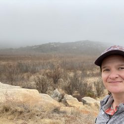
After passing this hike area while on the freeway I could finally say, I've hike that spot. But you know, there are more trail ways to explore than the Lake Hodges Trail that I hiked with a group of people. There is street parking, but that seems to fill quickly. I arrived to the area at 8am and was lucky to get street parking. But don't fret, there is a large 'dirt' parking area near by. The trail is quite easy with a few areas that have a bit more gravel and crevices, and moderate incline, very doable for active kids. Plenty of runners, mountain bikers, cyclists and of course hikers. Just be cautious with the cyclists, not all are equipped with bells. Once you get walking you forget about the freeway until you have to walk underneath it! I think the kids might find it amusing and you could study the structure beneath the freeway. You might get a couple of cool shots. Oh, and don't forget to cross over the walkway bridge and view the growth of trees in the lake bed that once was filled with water. I certainly will return to hike the other trails, and I'm sure I will enjoy the beauty it has to offer as this hike did.

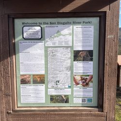
This review is focused on the Escondito entrance across from Westgate North Country Mall. There are a few parking areas, dirt and gravel so take it slow as you enter. There are trail head signs at each parking area and two booklets you can take with you explaining the Coast to Crest trail and other trails at Lake Hodges and other trails at San Pasqual Valley. This hike can be as short or as long as you wish. Once you enter the trail you will see the Sikes Adobe Historic Farmstead to the left. There is a sign directing you to Lake Hodges bridge, Bernardo MTN Summiet trail head, Mule Hill Interpretive site, Old Coach-Coast to crest trail link, and Raptor Ridge viewpoint. If you walk to the right you will follow the path under the bridge and then up the mountain. Dogs must be on a leash, there is no swimming. Horseback riding trail, please follow riding signs. No motorized vehicles. It is hot, bring plenty of water and sunscreen, very little to no shade. Park opens daily 6am Park closes at 6pm Oct.1 - March 31, 7:30pm April 1, Sept. 30. There is natural habitat that you cannot walk through, please be respectful of nature. Rattlesnakes,rabbits, coyotes, birds and other wildlife on trail.

Why am I giving this trail five stars? Because I like options! Any trail that runs the length of mountains to ocean has got to be incredible right? Yep! On this particular hike I took the Sunset Dr entrance across the street from the mall. Plenty of parking if lot is full there is a dirt lot they open up. So many trails, all leading to different adventures. It was hard to choose sometimes, and we eventually headed back after 2 miles. On the way I crossed a creek, bridges, many bikers and gorgeous settings taking you away from the sound of the freeway noise and taking you back into nature. Mostly flat terrain makes it simple to walk forever, there are rocky spots along the way but not bad at all. I will return, because honestly I have a lot more exploring to do.

I've been on this I need to get get back in shape, must make my 10k steps on my fitbit, how on earth did i gain so much weight last year oh yeah vacations are fun and i love food phase. I've been trying to think of places I feel ok to be hiking by myself. Probably not the best idea to hike by myself but I like my random spontaneous get off the couch and go for a hike moments. Clears my head and gets me out to enjoy nature. I did prefer to hike this trail rather than the other trail I have been going to at Kit Carson Park. There were a few people biking and running so it made me more comfortable being on this trail. I entered the trail off of Sunset near the North County Fair mall. I also visited the San Pasqual Battlefield earlier today and they mentioned Mule hill so I was curious and I wanted to take this hike to see it. I did like seeing all the signs explaining what happened at Mule Hill during the battle. Be careful when you start the hike because the golf balls from the driving range will come flying at you. This is a easy hike to see mule hill. It's almost a mile to get to it but I decided to walk a little further since I had time to explore before it got dark. I saw so many deer on my hike which was so cool. It was a nice 3 mile hike and I would love to come back again soon.

We parked by the entrance with a produce stand, off of the S-6 (or is it S-5)...I'm confused, wasn't the one driving. Some nice cardio. We saw some more tarantula hawks flying around, and lots of critters, skittering...nothing scary. Great scenery. Really enjoyed the hike, it was about 4 1/2 miles round trip. The pipe scope by the dam is a very nice piece of usable sculpture. Would do this one again, not very challenging, but fun.

A golf ball came within several feet of hitting my two year old son while we were walking on the coast to crest trail this afternoon. I had heard several balls hit ground nearby, but thought I was under estimating the distance. When one hit the ground in front of my son I panicked and ran away, quickly strapping him back in with the protection of the stroller. This is a tragic accident waiting to happen, and it nearly happened today. I regret not warning others that were passing by on the trail, and plan to call management of the Del Mar Golf center tomorrow. I will post an update if made safe for pedestrians as a path of travel.

My 1000th review goes to the Coast to Crest Trail which is the path of the coast of Del Mar going all the way inland towards Volcan Mountain by Julian! I love this hike within the San Dieguito River Park especially the San Pasqual Valley segment. I've been doing this particular hike along the trail the past four years and it's awesome. Parking is plentiful and a cinch to find! I start this at the *San Pasqual Staging Area* which starts by a citrus grove, then passes a large turf grass farm, abandoned buildings, a closed dairy, and scenic views from afar amidst the vegetation and unique species of plants along the path headed towards *Ysabel Staging Area* which is about 6 miles out and back. I definitely enjoy exploring the San Pasqual Agricultural Preserve and all of it's beauty and history. There are more bicyclists than hikers along this route, which is pretty sweet for it being a mellow path. Next time I definitely want to turn it up a notch by doing one of the longer hikes which I believe will be about 12- 22 miles if I go further out. :) read more


3 years ago
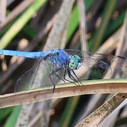
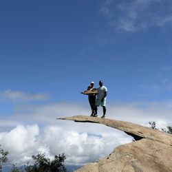
The Coast to Crest Trail is North County's Trail. No other hiking experience in San Diego gives you as much nature over such a long stretch of diverse land as the Coast to Crest. Starting in Del Mar and ending in Julian there are over 40 miles of connected trails, soon to be over 70 miles. If your hiking boots haven't touched this trail you probably haven't hiked North San Diego. If you're new to NC trails, put your fears aside. The Coast to Crest is a very safe and family friendly hiking system. There are some hills here and there, but overall it's a great healthy walk through San Diego's chaparral. - It doesn't matter if you take this trail section by section, or grind the 20 mile mega hike, this is a trail system that will keep your family busy for many weekends. - Many sections of the Coast to Crest are heavily used by mountain bikers. So keep your head up at all times. Tip - My favorite sections of the Coast to Crest trail are the East and West Santa Ysabel Preserves. Wildlife you're likely to see on The Coast to Crest. - Snakes - Coyotes - Rabbits - Deer - Stinkbugs - Large Turtles - Bats Sightseeing - Sikes adobe - Railroad tracks - Lake Hodges Dam - Lake Hodges Pedestrian Suspension Bridge - Volcon Airway Light Beacon - Clevenger Canyon Metal Chairs - Old Grand Avenue Overlook Bridge Best Off-Trails - Bernardo Mountain - Clevenger Canyon North and South Trails read more


10 years ago
After passing this hike area while on the freeway I could finally say, I've hike that spot. But you know, there are more trail ways to explore than the Lake Hodges Trail that I hiked with a group of people. There is street parking, but that seems to fill quickly. I arrived to the area at 8am and was lucky to get street parking. But don't fret, there is a large 'dirt' parking area near by. The trail is quite easy with a few areas that have a bit more gravel and crevices, and moderate incline, very doable for active kids. Plenty of runners, mountain bikers, cyclists and of course hikers. Just be cautious with the cyclists, not all are equipped with bells. Once you get walking you forget about the freeway until you have to walk underneath it! I think the kids might find it amusing and you could study the structure beneath the freeway. You might get a couple of cool shots. Oh, and don't forget to cross over the walkway bridge and view the growth of trees in the lake bed that once was filled with water. I certainly will return to hike the other trails, and I'm sure I will enjoy the beauty it has to offer as this hike did. read more


This review is focused on the Escondito entrance across from Westgate North Country Mall. There are a few parking areas, dirt and gravel so take it slow as you enter. There are trail head signs at each parking area and two booklets you can take with you explaining the Coast to Crest trail and other trails at Lake Hodges and other trails at San Pasqual Valley. This hike can be as short or as long as you wish. Once you enter the trail you will see the Sikes Adobe Historic Farmstead to the left. There is a sign directing you to Lake Hodges bridge, Bernardo MTN Summiet trail head, Mule Hill Interpretive site, Old Coach-Coast to crest trail link, and Raptor Ridge viewpoint. If you walk to the right you will follow the path under the bridge and then up the mountain. Dogs must be on a leash, there is no swimming. Horseback riding trail, please follow riding signs. No motorized vehicles. It is hot, bring plenty of water and sunscreen, very little to no shade. Park opens daily 6am Park closes at 6pm Oct.1 - March 31, 7:30pm April 1, Sept. 30. There is natural habitat that you cannot walk through, please be respectful of nature. Rattlesnakes,rabbits, coyotes, birds and other wildlife on trail. read more


Why am I giving this trail five stars? Because I like options! Any trail that runs the length of mountains to ocean has got to be incredible right? Yep! On this particular hike I took the Sunset Dr entrance across the street from the mall. Plenty of parking if lot is full there is a dirt lot they open up. So many trails, all leading to different adventures. It was hard to choose sometimes, and we eventually headed back after 2 miles. On the way I crossed a creek, bridges, many bikers and gorgeous settings taking you away from the sound of the freeway noise and taking you back into nature. Mostly flat terrain makes it simple to walk forever, there are rocky spots along the way but not bad at all. I will return, because honestly I have a lot more exploring to do. read more


11 years ago
I've been on this I need to get get back in shape, must make my 10k steps on my fitbit, how on earth did i gain so much weight last year oh yeah vacations are fun and i love food phase. I've been trying to think of places I feel ok to be hiking by myself. Probably not the best idea to hike by myself but I like my random spontaneous get off the couch and go for a hike moments. Clears my head and gets me out to enjoy nature. I did prefer to hike this trail rather than the other trail I have been going to at Kit Carson Park. There were a few people biking and running so it made me more comfortable being on this trail. I entered the trail off of Sunset near the North County Fair mall. I also visited the San Pasqual Battlefield earlier today and they mentioned Mule hill so I was curious and I wanted to take this hike to see it. I did like seeing all the signs explaining what happened at Mule Hill during the battle. Be careful when you start the hike because the golf balls from the driving range will come flying at you. This is a easy hike to see mule hill. It's almost a mile to get to it but I decided to walk a little further since I had time to explore before it got dark. I saw so many deer on my hike which was so cool. It was a nice 3 mile hike and I would love to come back again soon. read more


We parked by the entrance with a produce stand, off of the S-6 (or is it S-5)...I'm confused, wasn't the one driving. Some nice cardio. We saw some more tarantula hawks flying around, and lots of critters, skittering...nothing scary. Great scenery. Really enjoyed the hike, it was about 4 1/2 miles round trip. The pipe scope by the dam is a very nice piece of usable sculpture. Would do this one again, not very challenging, but fun. read more


4 years ago
A golf ball came within several feet of hitting my two year old son while we were walking on the coast to crest trail this afternoon. I had heard several balls hit ground nearby, but thought I was under estimating the distance. When one hit the ground in front of my son I panicked and ran away, quickly strapping him back in with the protection of the stroller. This is a tragic accident waiting to happen, and it nearly happened today. I regret not warning others that were passing by on the trail, and plan to call management of the Del Mar Golf center tomorrow. I will post an update if made safe for pedestrians as a path of travel. read more

7 years ago
6 years ago
6 years ago
My car was broken into today at approx 6:30pm. They stole some items out of my back seat that were completely hidden from sight. Please be careful in this parking lot. A few months ago, my friend had the same thing happen to her. These people must be hiding in the bushes and waiting. I'm honestly shocked no one heard or said anything because this parking lot was full of people. read more

11 years ago
More info about Coast To Crest Trail
Ask the Community - Coast To Crest Trail
Review Highlights - Coast To Crest Trail
You might also consider


Why does Yelp recommend reviews?
1 review that is not currently recommended
The reviews below are not factored into the business's overall star rating.
9 years ago
Coast To Crest Trail - hiking - Updated July 2026
Best of Escondido
People found Coast To Crest Trail by searching for…
Beautiful Views in Escondido, CA
Horseback Riding in Escondido, CA
Abandoned Buildings in Escondido, CA
Hiking Trails in Escondido, CA
Walking Trails in Escondido, CA
Running Trails in Escondido, CA
River Swimming in Escondido, CA
Natural Hot Springs in Escondido, CA
Dog Friendly Hiking Trails in Escondido, CA
Parks for Kids in Escondido, CA
Off Road Trails in Escondido, CA
Abandoned Places in Escondido, CA
Swimming Lakes in Escondido, CA
Stroller Walk in Escondido, CA
Waterfalls and Swimming Holes in Escondido, CA
Trending Searches in Escondido, CA
Beautiful Views near Coast To Crest Trail
Blueberry Picking near Coast To Crest Trail
Boat Tours near Coast To Crest Trail
Cliff Jumping near Coast To Crest Trail
Cruising Spots near Coast To Crest Trail
Day Trips near Coast To Crest Trail
Dog Friendly Things To Do near Coast To Crest Trail
Dog Friendly Trails near Coast To Crest Trail
Free Picnic Areas near Coast To Crest Trail
Jet Ski Rental near Coast To Crest Trail
Kayak Rental near Coast To Crest Trail
Kids Activities Indoor near Coast To Crest Trail
Lakes near Coast To Crest Trail
Lookout Points near Coast To Crest Trail
Nature Trails near Coast To Crest Trail
Night Hike near Coast To Crest Trail
Off Road Trails near Coast To Crest Trail
Outdoor Activities near Coast To Crest Trail
Parks near Coast To Crest Trail
Peach Picking near Coast To Crest Trail
Picnic Spots near Coast To Crest Trail
Places To Walk Around near Coast To Crest Trail
Public Shower near Coast To Crest Trail
River Swimming near Coast To Crest Trail
Rock Quarry near Coast To Crest Trail
Scenic Night View near Coast To Crest Trail
Scenic Overlook near Coast To Crest Trail
State Parks near Coast To Crest Trail
Surf Shop near Coast To Crest Trail
Swimming Holes near Coast To Crest Trail
Swimming Lakes near Coast To Crest Trail
Things To Do On A Rainy Day near Coast To Crest Trail
Tubing near Coast To Crest Trail
Watch Sunset near Coast To Crest Trail
Water Parks near Coast To Crest Trail
Browse Nearby
BEST of Escondido, California Restaurants near Coast To Crest Trail
BEST of Escondido, California Coffee near Coast To Crest Trail
BEST of Escondido, California Things to Do near Coast To Crest Trail
BEST of Escondido, California Parks near Coast To Crest Trail
BEST of Escondido, California Lakes near Coast To Crest Trail
BEST of Escondido, California Breakfast near Coast To Crest Trail
BEST of Escondido, California Campgrounds near Coast To Crest Trail
BEST of Escondido, California Sledding near Coast To Crest Trail
Browse Brands
Related Searches in Escondido, CA
Affordable Bike Repair Services in Escondido, California
Affordable Bike Tune Up Services in Escondido, California
Affordable Cheap Bike Tune Up Services in Escondido, California
Affordable Kayak Rental Services in Escondido, California
Affordable Road Bike Rental in Escondido, California
Best Dirt Bike Riding Spots in Escondido, California
Best Dog Hiking Trails Around Escondido, California
Best Electric Bike Rental Services in Escondido, California
Best Fishing Locations and Guides in Escondido, California
Best Nature Trails for Hiking in Escondido, California
Best Places for Horseback Riding in Escondido, California
Best Sightseeing Experiences Available in Escondido, California
Best Sledding Spots and Fun in Escondido, California
Check Out Off Road Trails in Escondido, California
Convenient Bike Sharing Programs in Escondido, California
Discover Dog Friendly Trails to Explore in Escondido, California
Discover Easy Hiking Trails Near Escondido, California
Discover Kid Friendly Hiking Trails in Escondido, California
Discover Popular Bike Tours in Escondido, California
Discover Popular Bike Trails in Escondido, California
Discover Scenic Bike Paths in Escondido, California
Discover Scenic Mountain Bike Trails Near Escondido, California
Discover Walking Parks in Escondido, California Near You
Discover a Hiking Trail in Escondido, California
Discover the Best Night Hike Trails in Escondido, California
Dog-Friendly Hikes With Dogs in Escondido, California
Enjoy Biking Adventures Around Escondido, California
Enjoy Camping Adventures Around Escondido, California
Enjoy Hiking Adventures in Escondido, California
Enjoy Kayaking Adventures in Escondido, California
Enjoy Off Leash Dog Hikes in Escondido, California
Enjoy Scenic Dirt Bike Trails Around Escondido, California
Enjoy Scenic Places to Walk in Escondido, California
Enjoy Tent Camping Spots Around Escondido, California
Enjoy a Beautiful Waterfall Hike in Escondido, California
Enjoy the Best Walking Path in Escondido, California
Enjoy the Best Walking Trails in Escondido, California
Explore BMX Bike Shops Near Escondido, California
Explore Beautiful Parks and Green Spaces in Escondido, California
Explore Bike Rentals Throughout Escondido, California
Explore Cycling Stores in Escondido, California
Explore Easy Hikes Perfect for All in Escondido, California
Explore Electric Bikes Available in Escondido, California
Explore Fun Activities to Do in Escondido, California
Explore Picnic Parks Near Escondido, California
Explore Popular Campgrounds Near Escondido, California


