
Hanauma Bay Trail Photos


You might also consider
More like Hanauma Bay Trail
Recommended Reviews - Hanauma Bay Trail
Start your review...

Reviews With Photos

Great hike, the path is paved and it is very accessible. We didn't park at Hanauma Bay to hike. We parked further down at the Koko Head parking spot and just crossed the street. The hike was less than 30 minutes but it was good and a great work out. I had to stop twice to catch my breath but it was well worth it, not as tough as diamond head. I recommend you do the hike before 9 am.

Usually, people just park at the Koko head crater parking lot and walk up to this trail. There is a big warning sign at the gate stated "Do not enter" but no one follow the rules and just enter, the entire trail is a paved AC path, you need to walk up some steep slope, but since the trail is only about 1.5 mile one way, it is not that bad at all. I ran up the trail because I want to get some training, but the rest of our group just walk up. Along the way, you can see Hanauma bay on your left and the Hawaii Kai and city view on your right, how can your beat that! Anyway, a short hike with amazing view, I highly recommended.

23 January 2022 The hike was fairly easy; it can be done in 30-45 minutes round trip. There is a bit of an incline but nothing too strenuous. We had same-day reservations to Hanauma Bay Preserve beach, so we parked in that parking lot and walked to the "trailhead" located at the intersection of the main road and Hanauma Bay access road. Upon entry, there are warning signs that caution 'Government Property, No Trespassing' yet EVERYONE avoids those signs. The trail itself is not anything magnificent. However, at various spots, there are amazing views of Hanauma Bay, Koko Head, and Hawaii Kai.

Nice morning hike with gorgeous views of the Hanauma Bay and Hawaii Kai. The trail starts on a paved road and gradually climbs its way up the ridge quickly offering views of Hawaii Kai and Hanauma Bay. After making it to summit there is a dirt road/trail to your left that will take you around a hillside overlooking the ocean and Hanauma Bay. The trail down can be slick on the rocks after a rain do wear hiking boots. We also added the trail down to the Natural Bridge. This section may make beginner hikers nervous since it does make its way down to the ocean down a steep rocky eroded terrain, need to watch your footing. It is well worth the hike, with stunning views of the powerful ocean. WARNING: during high surf or tide or anytime be very careful to keep safe distance from the waves. We hiked back the way we came up to loop and continue on the trail. Last half of this trail is steep and less seasoned hiker may need a few breaks. Along this stretch of the trail there are gorgeous views of the bay. Once we made it back to paved trail it's a pretty easy stroll down the road. It's close to some restaurants and ice cream shop for a well earned Reward. Tips: if you are going on the dirt trail hiking boots are recommended and poles. There little shade on trail so morning is best time. Bring plenty of water and snacks.


Nice inclined paved hike once you actually reach the trail. The first hill seems steep and endless but I love it! In fact, I would do this hike daily if I actually lived in town. The path is wide enough to pull on the side for a quick break and to enjoy the views. It took us about 30mins up and 30 minutes down, exactly an hour. But we stayed to watch the views along the way. It's not far up from parking in the residentials on Nawiliwili street right after Lunalilo Home Road. But still, like most hikes, i wouldn't have known where to cut up unless I was with a friend who has been here before. She has a goal of completing 100 hikes by the end of this year and I was finally able to tag along on #84! Is it kid friendly? Kind of, just pay attention to them so they don't wander off the cliff. It was really windy walking up which was a nice breeze but make sure to hold onto the stroller so that it doesn't roll off as there are no guard rails. I'd actually recommend 2 people holding it in case you trip..it's a little steeper than Makapu'u. Other than that, it's free!

Definitely a fun change up from your typical Makapuu trail or Koko Head hike. I did a bunch of research on this trail because technically it's not an actual trail...meaning it's not for hiking hahaha....but tons of people still go on it. It's totally safe and paved one way so you can't get lost -- except when looking for the entrance. To save 15 minutes, definitely take the shortcut by the yellow "Begin Enterline Rumble Strip" (see picture) It's hard to see the dirt path because of the grass but all you have to do is follow it until you reach pavement! Then continue to the right and keep going up until your desired height. This trail is perfect for a sunrise hike because there really isn't anything blocking your view (except clouds...) and you get more of a nature feel. The incline can feel like it's going on forever but persevere because the view is definitely worth it! I haven't done the loop around so I'm not sure what's on the other side. This trail is also known for the rock bridge location which I believe is on the side of the mountain so you have to go off-path. Just be careful searching for it because it can get slippery going down that way. This hike has such beautiful lighting; I don't know if it's because the sun just came out but it's stunning. If you do decide to see the sunrise here, definitely bring a jacket because it is absolutely freezing! I was a popsicle by the time the sun came out but it was definitely worth it.

Trail is super easy and great for the family. It's a simple walk up along the ridge on a paved walkway. When you park and walk back up to the front entrance near the bus stop, you'll see a large secured gate with "No Trespassing" signs posted, but just ignore it and keep walking through. There, you will pretty much walk a one way path straight to the top to see some beautiful view of Hanauma Bay, Kokohead, Hawaii Kai, etc. At the very top, you can walk back down a slanted hillside where the dangerous rock bridge is located, but I never wanted my kids anywhere near that so we didn't go all the way. The parking lot is huge, but sometimes gets full. It costs $1 for entry. Bring water and wear shoes.
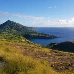
This is my go to hike when I just want to get away for a few hours. It is not a difficult hike, about 4 miles round trip. The hike is is really nice and the views are always great. Sometimes this hike is so brown but today because of the rain everything was so green. So it is nice because the hike can be so different depending on when you do it during the year. The reward for a little effort are amazing views of Koko Head as well as Hanauma Bay. Hike down to the lava bridge if you are feeling energetic. Remember to be safe and bring lots of water. If you are bringing your four legged friends, bring water for them as well. You can find parking in the neighborhood but remember people live here so try not to be too loud and show aloha and don't leave behind any trash. Great hike and I can't wait to do it again!

Great hike today!! We were looking for something quick to do at noon on a Saturday so decided to take our 5lb Yorkie for a walk. You actually park just a little ways down from the trail in a residential area. Just make sure you don't park too close to someone's driveway. The hike at a good speed was about one hour. Great views of Hanauma Bay from up top. The trail is paved so you could take a baby joggers stroller if you wanted. It's a little rough so I wouldn't take a regular stroller. If you've hike to Makapu Trail to the lighthouse, this one's a little steeper so you have a little bit more of a work out. But still pretty easy hike for any age. Can get windy so hold on to your hat!


I've always wanted to do this trail, but never found the time (i.e. I was too lazy!). Good news! I got off the couch and found the time! I'm glad I did! The Hanauma Bay Trail is a very simple and straightforward hike. You go up and down, then back up and down. There are nice views all around you with Diamond Head on one side, Hawaii Kai and Koko Crater Stairs is Death, and Hanauma Bay below. This trail isn't an official hike as the starting point is located off to the side of the Hanauma Bay entrance, behind TheBus stop where you will see a gate with a "NO TRESPASSING, subject to a violation and a fine" sign. It's a-okay. Many, many people do this hike everyday. Just go through the gate and follow the paved road up. It's a nice steady incline with a couple areas where it steepens, but it's fine. Just look behind you at the Koko Crater Stairs, and be happy you're here and not there! At the summit, it splits to two paths. The left side will take you down towards the ocean and rocks, the right takes you to the communications towers and just further along the top to the ocean side. There's no private lot parking for this hike. You have a few options: parking at Hanauma Bay for a fee and walk back up, park at the Koko Head District Park on Kamaukani St and up the road towards Kalanianaole, or park on Nawiliwili St/the side street right before Hanauma Bay and walk up. From Nawiliwili St, there should be a dirt path way that connects to the trail, but the grass is overgrown and currently covers the path. It's a nice hike and a good alternative from the Lighthouse Hike.

A very very hidden hike. My friend and I found it because we were reading a bunch of reviews on yelp and blogs. We started this hike early morning. Parking is near a residential area on the side. Very convenient. The trail is on Kalanianaole Highway. The road toward Hanauma Bay. After parking on Nawiliwili Street, you walk about 5 minutes or so and the trail is passed the chain driveway. You explore into the jungle...or grassy area. You keep hiking up until you see a paved black road. There are quite a few people hiking here so you're not alone. Once you hit the paved road you turn right and walk straight for like 15-20 minutes or so? You'll see a trail into the grassy area. The hike down is steep and rocky. The road to the bridge is up and down. It's a leg workout. You keep walking straight until you can see the ocean straight ahead. You go down steep chunky rock platforms. Once you hike down, near the edge is the bridge on the right. It's a small bridge. Different from what you see in pictures. My description isn't that clear but read more reviews before going!!! It's good to do research on it before exploring. We took a lot of wrong turns and wasted 2 hours finding the bridge. It's really hidden! Don't forget to stretch your legs after because it'll hurt tomorrow.

Living in Hawaii is expensive..... My mental health these days have been taking a toll on me. Taking myself out for a walk turned into a weekly hike! Appreciating the views and finally enjoying it when I'm not slaving my hours away at work... I'm scared of heights... so this has became my favorite hike as it not only has a beautiful view without triggering my fear. Also, it gives me the chance to be spontaneous and face my fears if I want to go off trail.... The hike is not crowded like kokohead just across the street of this. 2025 is to enjoy the outdoors and to be healthier. For real though, I hike to eat and food solves all problems after. read more


1 year ago
Very clean easy to walk and dog friendly hike. But no shade! Highly recommended to go early and bring water for your dog! One point there is a steep hill. Take less than 2 hours. Very nice view!! read more


Beautiful sunrise view. I'm admittedly a wimp when it comes to hiking but this was beautiful and very much worth an early morning hike. We came with a local who drove us at around 5am in the morning, and we went to a spot that had a steep path that led to a cliff that had a gorgeous and stunning view of Hanauma Bay and Diamond Head. The view and the sunrise was absolutely breathtaking. Since this was my first time in Hawaii, I wanted to witness a gorgeous Hawaiian sunrise, and this absolutely fit the bill for me. Bring sunscreen, water, hiking shoes, and adequate sun protection clothing! read more


Great hike, the path is paved and it is very accessible. We didn't park at Hanauma Bay to hike. We parked further down at the Koko Head parking spot and just crossed the street. The hike was less than 30 minutes but it was good and a great work out. I had to stop twice to catch my breath but it was well worth it, not as tough as diamond head. I recommend you do the hike before 9 am. read more


3 years ago
Usually, people just park at the Koko head crater parking lot and walk up to this trail. There is a big warning sign at the gate stated "Do not enter" but no one follow the rules and just enter, the entire trail is a paved AC path, you need to walk up some steep slope, but since the trail is only about 1.5 mile one way, it is not that bad at all. I ran up the trail because I want to get some training, but the rest of our group just walk up. Along the way, you can see Hanauma bay on your left and the Hawaii Kai and city view on your right, how can your beat that! Anyway, a short hike with amazing view, I highly recommended. read more


4 years ago
23 January 2022 The hike was fairly easy; it can be done in 30-45 minutes round trip. There is a bit of an incline but nothing too strenuous. We had same-day reservations to Hanauma Bay Preserve beach, so we parked in that parking lot and walked to the "trailhead" located at the intersection of the main road and Hanauma Bay access road. Upon entry, there are warning signs that caution 'Government Property, No Trespassing' yet EVERYONE avoids those signs. The trail itself is not anything magnificent. However, at various spots, there are amazing views of Hanauma Bay, Koko Head, and Hawaii Kai. read more


Nice morning hike with gorgeous views of the Hanauma Bay and Hawaii Kai. The trail starts on a paved road and gradually climbs its way up the ridge quickly offering views of Hawaii Kai and Hanauma Bay. After making it to summit there is a dirt road/trail to your left that will take you around a hillside overlooking the ocean and Hanauma Bay. The trail down can be slick on the rocks after a rain do wear hiking boots. We also added the trail down to the Natural Bridge. This section may make beginner hikers nervous since it does make its way down to the ocean down a steep rocky eroded terrain, need to watch your footing. It is well worth the hike, with stunning views of the powerful ocean. WARNING: during high surf or tide or anytime be very careful to keep safe distance from the waves. We hiked back the way we came up to loop and continue on the trail. Last half of this trail is steep and less seasoned hiker may need a few breaks. Along this stretch of the trail there are gorgeous views of the bay. Once we made it back to paved trail it's a pretty easy stroll down the road. It's close to some restaurants and ice cream shop for a well earned Reward. Tips: if you are going on the dirt trail hiking boots are recommended and poles. There little shade on trail so morning is best time. Bring plenty of water and snacks. read more


2 years ago
I love this hike! A paved path with an incline but usually not busy so you can go at your own pace. The views are to die for! read more
Nice inclined paved hike once you actually reach the trail. The first hill seems steep and endless but I love it! In fact, I would do this hike daily if I actually lived in town. The path is wide enough to pull on the side for a quick break and to enjoy the views. It took us about 30mins up and 30 minutes down, exactly an hour. But we stayed to watch the views along the way. It's not far up from parking in the residentials on Nawiliwili street right after Lunalilo Home Road. But still, like most hikes, i wouldn't have known where to cut up unless I was with a friend who has been here before. She has a goal of completing 100 hikes by the end of this year and I was finally able to tag along on #84! Is it kid friendly? Kind of, just pay attention to them so they don't wander off the cliff. It was really windy walking up which was a nice breeze but make sure to hold onto the stroller so that it doesn't roll off as there are no guard rails. I'd actually recommend 2 people holding it in case you trip..it's a little steeper than Makapu'u. Other than that, it's free! read more


Definitely a fun change up from your typical Makapuu trail or Koko Head hike. I did a bunch of research on this trail because technically it's not an actual trail...meaning it's not for hiking hahaha....but tons of people still go on it. It's totally safe and paved one way so you can't get lost -- except when looking for the entrance. To save 15 minutes, definitely take the shortcut by the yellow "Begin Enterline Rumble Strip" (see picture) It's hard to see the dirt path because of the grass but all you have to do is follow it until you reach pavement! Then continue to the right and keep going up until your desired height. This trail is perfect for a sunrise hike because there really isn't anything blocking your view (except clouds...) and you get more of a nature feel. The incline can feel like it's going on forever but persevere because the view is definitely worth it! I haven't done the loop around so I'm not sure what's on the other side. This trail is also known for the rock bridge location which I believe is on the side of the mountain so you have to go off-path. Just be careful searching for it because it can get slippery going down that way. This hike has such beautiful lighting; I don't know if it's because the sun just came out but it's stunning. If you do decide to see the sunrise here, definitely bring a jacket because it is absolutely freezing! I was a popsicle by the time the sun came out but it was definitely worth it. read more


7 years ago
Trail is super easy and great for the family. It's a simple walk up along the ridge on a paved walkway. When you park and walk back up to the front entrance near the bus stop, you'll see a large secured gate with "No Trespassing" signs posted, but just ignore it and keep walking through. There, you will pretty much walk a one way path straight to the top to see some beautiful view of Hanauma Bay, Kokohead, Hawaii Kai, etc. At the very top, you can walk back down a slanted hillside where the dangerous rock bridge is located, but I never wanted my kids anywhere near that so we didn't go all the way. The parking lot is huge, but sometimes gets full. It costs $1 for entry. Bring water and wear shoes. read more


This is my go to hike when I just want to get away for a few hours. It is not a difficult hike, about 4 miles round trip. The hike is is really nice and the views are always great. Sometimes this hike is so brown but today because of the rain everything was so green. So it is nice because the hike can be so different depending on when you do it during the year. The reward for a little effort are amazing views of Koko Head as well as Hanauma Bay. Hike down to the lava bridge if you are feeling energetic. Remember to be safe and bring lots of water. If you are bringing your four legged friends, bring water for them as well. You can find parking in the neighborhood but remember people live here so try not to be too loud and show aloha and don't leave behind any trash. Great hike and I can't wait to do it again! read more


Great hike today!! We were looking for something quick to do at noon on a Saturday so decided to take our 5lb Yorkie for a walk. You actually park just a little ways down from the trail in a residential area. Just make sure you don't park too close to someone's driveway. The hike at a good speed was about one hour. Great views of Hanauma Bay from up top. The trail is paved so you could take a baby joggers stroller if you wanted. It's a little rough so I wouldn't take a regular stroller. If you've hike to Makapu Trail to the lighthouse, this one's a little steeper so you have a little bit more of a work out. But still pretty easy hike for any age. Can get windy so hold on to your hat! read more


5 years ago
Really nice and paved Hike along Hanauma Bay. You'll enjoy views of Hanauma Bay and also Hawaii Kai. I recommend parking at Koko Head and walking up to the Hanauma Bay Trail. You have to climb through a Gate to enter the trail. read more

I've always wanted to do this trail, but never found the time (i.e. I was too lazy!). Good news! I got off the couch and found the time! I'm glad I did! The Hanauma Bay Trail is a very simple and straightforward hike. You go up and down, then back up and down. There are nice views all around you with Diamond Head on one side, Hawaii Kai and Koko Crater Stairs is Death, and Hanauma Bay below. This trail isn't an official hike as the starting point is located off to the side of the Hanauma Bay entrance, behind TheBus stop where you will see a gate with a "NO TRESPASSING, subject to a violation and a fine" sign. It's a-okay. Many, many people do this hike everyday. Just go through the gate and follow the paved road up. It's a nice steady incline with a couple areas where it steepens, but it's fine. Just look behind you at the Koko Crater Stairs, and be happy you're here and not there! At the summit, it splits to two paths. The left side will take you down towards the ocean and rocks, the right takes you to the communications towers and just further along the top to the ocean side. There's no private lot parking for this hike. You have a few options: parking at Hanauma Bay for a fee and walk back up, park at the Koko Head District Park on Kamaukani St and up the road towards Kalanianaole, or park on Nawiliwili St/the side street right before Hanauma Bay and walk up. From Nawiliwili St, there should be a dirt path way that connects to the trail, but the grass is overgrown and currently covers the path. It's a nice hike and a good alternative from the Lighthouse Hike. read more


A very very hidden hike. My friend and I found it because we were reading a bunch of reviews on yelp and blogs. We started this hike early morning. Parking is near a residential area on the side. Very convenient. The trail is on Kalanianaole Highway. The road toward Hanauma Bay. After parking on Nawiliwili Street, you walk about 5 minutes or so and the trail is passed the chain driveway. You explore into the jungle...or grassy area. You keep hiking up until you see a paved black road. There are quite a few people hiking here so you're not alone. Once you hit the paved road you turn right and walk straight for like 15-20 minutes or so? You'll see a trail into the grassy area. The hike down is steep and rocky. The road to the bridge is up and down. It's a leg workout. You keep walking straight until you can see the ocean straight ahead. You go down steep chunky rock platforms. Once you hike down, near the edge is the bridge on the right. It's a small bridge. Different from what you see in pictures. My description isn't that clear but read more reviews before going!!! It's good to do research on it before exploring. We took a lot of wrong turns and wasted 2 hours finding the bridge. It's really hidden! Don't forget to stretch your legs after because it'll hurt tomorrow. read more


There isn't a trail in HI that I don't absolutely love (as you may have noticed with all my 5 stars) but this one is definitely different than the other ones. There are spots where you'd think you were transported to Mars (okay, realistically AZ or UT). The review includes the trails to the Rock Bridge. (Before continuing, take note that there is a fence and signs that say do not enter towards the entrance if you're coming from the Hanauma Bay parking lot area. This is government property. That said, this trail is one of the most trafficked: each time I come here, I pass more than 20 people.) Started early to watch the sunrise from the top of Hanauma before trekking down to mountain side towards the Rock Bridge. There is no cover on this trail except what looks like an oasis made up of maybe 5 smaller trees. So, take sunscreen, glasses, hat, good treaded shoes, umbrella (just joking on this as you'll need your hands in some spots), and plenty of water. Parked in the neighborhood street immediately before the parking lot entrance to Hanauma Bay. Then jumped over a small canal towards the end of the side street and started climbing until the main paved road came up. Walked up towards the first satellite. You'll be going up and up and up...you get the picture. Before the final hill towards the satellite, there should be a worn path across grass on your left towards the ocean. Take it and then walk towards the right until you see another trail to the left that shows a path down (and up and down and up) the hillside. You should also see the oasis I referenced above. Just follow that trail and keep going down towards the ocean. You'll cross into what looks like the foreign landscape I mentioned and you'll eventually see the Rock Bridge on the right. Recommend low tide if you want to take a pic on the Bridge but there's always the chance or a rogue wave. People have been swept off the Bridge so for me, just looking at it was enough. And there's so many other things to climb around there anyway. Not an easy trail but definitely not difficult either. I've seen kids and dogs on the trail towards the Rock Bridge including a short-legged fellow who was kicking his fur-parents' butt on the climb back up. Plan on about 3 hours round trip especially if you're a photo taker (and therefore explorer for the perfect spot) like me. read more


Easy workout on your legs and glutes on the ascend. Enjoy the sunshine and winds from all directions. 360 view of the Hawaii Kai side as well as creeping on Koko Head and Hanauma Bay. As always. Enjoy the Hi Life. Lucky we live Hawai'i!!! read more


Located right across the street from the Koko Head trail, I consider the Hanauma Bay Trail Koko Head's little sister. This particular hike definitely isn't as strenuous as Koko Head because the incline isn't as steep but trust and believe-she will still give you a good calf burn. The main trail is paved most of the way and is a relatively short hike (if you stay on the paved trail) and worth a shot because of the beautiful panoramic, actually, more like 360 degree and unobstructed view of Hawaii Kai, Koko Head and Hanauma Bay. While most of the main trail is paved, there are many unpaved routes that lead down to the rock bridge. As always, every hike is what you make of it and depending on what type of hike you're looking for, you can go beyond the paved walkway and explore the rocky area of the bay. While I can say much more about this trail's beauty, I will let my pictures speak for themselves! read more


NO! (I don't want to hike Koko Head! How about something easier?) http://www.yelp.com/biz_photos/U1cqWabCNeexNlD_pZQuWw?select=28-ChEQE66oYnRrqh05W0Q This is way easier. There are no stairs, no ladders, no ropes, no bridges. NO WAY! (But I don't hike!) http://www.yelp.com/biz_photos/U1cqWabCNeexNlD_pZQuWw?select=2ON40TXMTJYFgqDLNUUnSg It's all paved, just think of it like a treadmill on 17% incline! NOOOOOOOOO! (But I'm afraid of heights!) http://www.yelp.com/biz_photos/U1cqWabCNeexNlD_pZQuWw?select=hk2c-zOlH363yURDBY5QPQ You're not that high up, and there are no cliffs to fall off. Oh WOW. (it's so peaceful up here! Go on Tuesdays when the bay is closed and your view is completely free of people!) http://www.yelp.com/biz_photos/U1cqWabCNeexNlD_pZQuWw?select=4S8Oj-Yur4i-As6QND_9sg See? I told you, this is awesome! http://www.yelp.com/biz_photos/U1cqWabCNeexNlD_pZQuWw?select=JSvUwEfxWTvrvUqkPGZvMg This is a great hike for non-hikers (and my little kids) who just want a little bit of exercise with a rewarding panoramic view from Diamond Head to Sunset Beach. We also saw several whales out in the distance doing their thing as a bonus! If you just go up to the tower on top and back it's about an hour roundtrip (or faster if you run up and down). There are multiple trails that lead down to the ocean but for me, I'll just stick to the paved portion for now. See Brandon Y.'s review for directions on how to get there. It was really windy one time and I had to hold both kids' hands as we went back down because they thought they were going to blow away, but they had a blast! Thanks Chad! read more


Yes, this hike is illegal. Now that we've got that out of the way, we parked in the Hanauma Bay lot before sunrise, so we avoided paying the parking fee (which is only $1). The start of the trail is located right next to the Hanauma Bay entrance/bus stop. You'll have to go through the gate, and you're on your way! It's uphill for a while, and there's many paths that you can take, depending on where you wanna go. If you got straight up, theres cellphone towers? or some kind of towers - really cool but they're gated off so look with your eyes only! You get a sick view of the sunrise/sunset because it's all just ocean and nature from the top. Although it's illegal, no one really cares - there were numerous hikers, even some tourists that did it. When we were leaving the trail, there were security guards for Hanauma Bay outside the gate. We came out, took pictures, said hi to them, and left. So again, it's illegal, but not that illegal, if ya know what I mean. *Tips! - if you want to see the towers, just go straight up. I would bring some speakers, because it took about 40 minutes to get to the top, and it would definitely pass the time quicker. If you wanna get to the rock bridge, there's a secret little path on the left side of the road while you're walking up. It's a little hard to explain, so you may just have to search for it yourself (more adventures!) but it's a shaven little path covered by grass. You'll see a few when you're walking up, but I believe the one that we came out from was the second to the last one. There's numerous ways to get down there, but our way took about an hour, because we started from the top. Overall, our hike took a good three hours, including picture taking (a lot of picture taking) and breaks. GO FOR SUNRISE. IT'S TOTALLY WORTH. TRUST ME. and BRING A CAMERA IF YOU HAVE ONE. read more


 - Hiking Near Me - Honolulu, Hawaii")


If you're looking for a hike to capture that sunrise Hanauma Bay Ridge line is it. It's a moderate trail all gravel. There is one massive incline and then it goes flat and then after another mild incline hill it's all flats to where you a beautiful spot to sit and enjoy the view of that sun rising. This year for Thanksgiving 2020 my sisters and I went up for that beautiful sunrise and it was great. read more


I came here the other week with some Yelp friends to venture all the way down to the rock bridge. In the early morning the tide is low enough where you can stand on the bridge. I've seen photos in the past and sooooooo wanted to come here. I initially came here with a friend several months ago only to get lost. We started at the "Hanauma Bay Nature Preserve" sign and walked up the slope to the very end. We didn't know where to hike down!!! So when a friend offered to take a group of us on an early Saturday morning, I jumped at the opportunity! About a little past halfway going up, there is a nasty slope going down where it's steep. And trust me, this steep slope goes quite all the way down. Make sure to have good traction on your shoes because all it takes is one slip and you'll be tumbling down. Once you make it down to the flat level, there is a great photo op for Hanauma Bay closeup. While taking some pics, it was a great opportunity to refuel with some water and/or snacks. From here on, it was somewhat a scary climb down as you can see crystallized salt grains. With no designated trail going down, I took my time and perhaps too the long way down as I found myself chickening out! Eventually our whole group made it down safely and luckily Mother Nature was good to us as we snapped away pic after pic. We saw a lot of small marine life in the tide pools while listening to the waves crash along the coast. On the way back up can be a challenge. It is compared to the stairs of Koko Head but for me personally, this was much easier. The planks going up Koko Head Railway Trail is not even - - the height and width of each plank differ so it's definitely more challenging! Overall, a great hike on a clear morning. Make sure the trail is dry as I DO NOT recommend coming down the the rock bridge if it's raining or has been raining. NOTES: 1) Apply sunscreen before your venture. This hike is out in the open and you're fully exposed to the sun. 2) Highly recommend you to carry water and perhaps bring some snacks. You may find the need to take occasional breaks depending on your cardio conditioning. 3) Hike with a friend - - DO NOT come here alone. 4) Make sure to have good traction on your shoes. read more


Decided to try the Hanauma Bay Hiking Trail for the first time on Thanksgiving morning :) One of the great perks of living in Hawaii~! I'm guessing there are a couple ways to start this hike. We ended up parking in the residential area right next to Hanauma Bay and then walked up to this grassy area. I really don't know how to describe it haha. We started here: http://www.yelp.com/biz_photos/hanauma-bay-trail-honolulu#9ACZPtQCtJAyBCHtLRB8yA I'm not sure if it is always this way or if its just the time of year... But my first experience here was....well let me tell ya. 1) The Bee's. WHERE EVERYWHERE. OMG. I swear to god there was over 100s bee's flying around me. There was the big fat black ones AND the yellow bee's! Way too much.. I was so scared I was going to get stung. But thankfully no one in our group got attacked! 2) The wind. Holy poop is was so windy! It was so windy I felt like I was going to constantly fall over =/ (and I actually did fall over a couple of times, but I think that was a combinations of the wind and my junk shoes). However, on a brighter note - I think its because of the wind that the bee's didn't sting us, they were too busy trying to fly in that crazy wind to notice us passing through them. 3) The rock bridge. The day we came the waves were really rough. We even got hit by one! And we weren't even close to the edge!! So none of us wanted to actually stand on the rock bridge cause it was way to dangerous. Even if the waves weren't rough, why is this so cool? I mean I saw it but I don't get it lol. After when we were done to with the rock bridge and started hiking back up, we saw this plant http://www.yelp.com/biz_photos/hanauma-bay-trail-honolulu#azVtVJYhQOfOJd1NhnLxYQ anyone know what it is? Overall: I think I would have enjoyed this hike more if it wasn't so windy and covered in bee's. Luckily it was overcast so we didn't get any sunburns. I thought it wasn't so bad getting to the rock bridge. I think the hardest park is coming back.. I know I had to personally take a couple breaks on the way up =___= But on another brighter note, I got some good pictures on this hike :) I got some great photos from this hike :) http://www.yelp.com/biz_photos/hanauma-bay-trail-honolulu#O392VBwXG-5lQyLYETdRvQ TIP- make sure you wear shoes that has good grip. The grip on my shoes were all worn out and I actually fell down a few times from slipping :( read more


11 years ago
If you want a fairly easy trail, this is a great one. The only thing is you'll be walking up and down steep hills (which is also a good workout!!!). The "bridge" everyone goes to is just okay to me. It's literally just a huge rock that goes over water. But you need to be very careful here. Waves down there can be unpredictable so just make sure you are always aware of the movements of the ocean. What I really like about this trail is the awesome view. You can see Koko head, Hanauma Bay, Hawaii Kai, etc. It's beautiful! read more


It was my first time hiking this trail and it was a perfect day to do so. The winds helped keep me cool as the sun was baking hot. The entrance to the trail is to the right; before the drive down into Hanauma Bay. There is no public parking available at the trail entrance. Your options are either to park in Hanauma bay or at Koko Head district park. The gate to Hanauma Bay Nature Preserve was closed when we went so we just went under it. I think the gate is mainly used to keep cars out. From my understanding Hanauma bay trail is a crater so you can either go clockwise or counter clockwise. Most people go the quickest way to the rock bridge, which is clockwise. In my opinion going clockwise has a steeper initial slope. Counter clockwise has a gradual slope down. When I got to the rock bridge which was late in the morning, the waves were crashing high. So I didn't attempt to stand on the bridge. Overall is a beautiful easy hike with spectacular views of Hanauma Bay. read more


Whew! What a work out for me. As you could probably tell, I am not the most athletic person. I go to the gym sometimes and that's just not enough. Plus, I'm one of those clumsy ones. Yes, I did fall down and yes, I'm one of those who screams when I slip, too. So far me, this Hanauma Bay Trail was just right for me. It starts out with a paved trail going up a fairly steep incline. Then you get to travel down a rocky dirt trail to see the beautiful view of Hanauma Bay. The view is absolutely superb, a peaceful sight of the ocean blue and vibrant green koko head. I might have gotten a nasty cut from this trail but it was well worth the 3 hour work out. Yes, I was a trooper. This was a true work out for me, I was all sweating and huffing. Bring water and wear sunscreen, there's no shades. You will be soaking up some sun on this amazing Hanauma Bay Trail. read more


Love to hike this trail, love how its all on paved road. Though, it is a private property owned by the state you could be risking a fine if you are ever caught! But i have been here at least 3-4 times now and havent seen anyone or any car that goes around telling you something. The hiking trail alone is kind of tough at first because it was all up hill for the first 15 minutes but I swear the views make up for it. The views are amaaaazing!! Especially of the bay (Hanauma Bay) Overall, I love to do this hike! And if its gonna be your first time you wont be disappointed read more

This trail kicked my ass. I wasn't expecting to hurt this much since I've heard it's easier than hiking Koko Head Crater. I suggest hiking with a buddy, staying hydrated, wearing sunscreen & bringing a camera (fully charging your smartphone). There are steep hills & I would proceed with caution. Don't worry about going at a Grandma's pace OR crawling like a spider monkey to climb up/down because I've done both. There was actually a grandma, who was fearless & climbed the steep hills (I'm slightly embarrassed she was kicking my ass). Take your time to enjoy the view & remember to stretch! read more


11 years ago
This is one of those "things" I have been wanting to do since we moved here 3 years ago. Now I wish we would have gone sooner so we could go more! The views are breathtaking and the peacefulness you have on this hike is amazing. It is not a hard hike, but rather on a poorly paved road, but safe. There are no trespassing signs at the beginning of the trail, but that translates to enter at your own risk. However, stick to the road. There are worn paths from other hikers, but it doesn't take a rocket scientist to figure out the terrain off the road is slightly unstable. Please don't get all crazy and go down to baboon's nose...its very dangerous. Plus, what is often easy to get to isn't as easy getting back to safety. Please don't put the life guards at Hanauma Bay at risk because you wanted to take a risk. There is plenty to take in and explore on the road from the bay, Koko Head, Sandy Beach, Diamond Head, and Hawaii Kai to name a few. If you are lucky you can see Molokai and maybe even Lanai. Plus, you may be able to catch the whales as well. My only issue with this hike is no shade and no place to really sit down to take a break. Not that I need one...but its nice to take in the views instead of go-go-go...then again...there is a no trespassing sign... read more

8 years ago
This is a quick and fairly easy hike close to our home so it's easy enough to get to for a sunset hike! Please be aware this trail is not officially open to hikers - at the trail head at the entrance of Hanauma Bay there are signs saying it's not open to the public. Nevertheless, many people take their dogs and other loved ones for a walk on the paved trail. There's a steep section but otherwise it's an easy hike punctuated by astounding views of Hanauma Bay, Koko Crater, Hawaii Kai and even Diamond Head in the distance. Along the way you'll come across the radio facilities that are the reason for the trail's maintenance; at the very end of the trail, there are signs over the gates that indicate you don't want to linger as there is some radiation emitted from the facility. ??? In any case, there are other unpaved trails on either side of the main one; on the Hanauma Bay side there are some that go down to the water, apparently. Best place to park is Koko Head District Park in the lot closest to the highway. The trail from there will lead you past the gun range to the crosswalk at the entrance of Hanauma Bay. read more


My group of friends decided to try this hike on a Saturday morning. It is located at Hanauma Bay, and is basically a trail around the top of the bay, overlooking it with beautiful views. Parking is no problem as you can park at the Hanauma Bay parking lot for a $1 flat fee. There is ample parking there. You can also park on the street in the residential areas or at Koko Head District Park, if you don't mind walking a bit more. So we parked in the lot for $1 and proceeded to the entrance of the trail, which is located at the driving entrance to Hanauma Bay, near the bus stop. I guess I should have mentioned this before. This is not an official hiking trail and is considered an illegal hike. So that was my disclaimer *wink* *wink*. Many people hike this trail everyday and we encountered several other hikers that morning, some even walking their dogs. At the entrance of the hike, there is a no trespassing gate and sign, but people just ignore that and proceed. You can also enter the trail further down through side routes. The hike itself was a great workout with amazing views of the bay as we walked along the top of the mountain. You can stay along the paved trail all the way to the end. However, we took one of the side trails down to the famous Rock Bridge. This side trail takes a little more effort as we had to maneuver down a slippery dirt trail, and later down the rocks to the ocean shoreline. If you go down this side trail, wear good shoes as it can be slippery. I don't recommend going this route if it has been raining or is wet. We reached the Rock Bridge but the high waves that morning prevented us from going too close. Some people stand on the bridge to take pictures. But not me because I'm a scaredy cat, so I was not disappointed when we couldn't get too close. The return hike up the side trail was a little strenuous but manageable. Overall, it was a fun scenic hike and a great workout. It's a good hike for beginner and intermediate hikers. The entire hike took about 2.5 hours, but we rested a lot.....ok correction, I rested a lot. We ended with brunch at Moena Cafe, which I also highly recommend. read more


Have walked this ridge trail many times in the late afternoon and evening. Beautiful sunset views of Diamond Head and Honolulu. Easy one mile walk in each direction to the end of the paved trail. Yes, you'll be trespassing. So many of Oahu's trails are technically illegal. Oh well... read more


Ok so we got here kinda late, maybe about 6pm almost. We had to cheat the trail a little bit and went up a shortcut straight up a mountain on the side. Pretty steep going up but quick like maybe 5-10 mins up. Anyway once we got up to the trail, we were at least 1/4 up, which was awesome! The entire trail was pretty much a pavement road going UP. The incline killed me a bit but that's okay cause it made me sweat hard and tone up my legs and thighs. The views all around were breath taking. Caught a capture of the beautiful sunset out facing Hawaii Kai as you can see in my photos. You can also Koko head & Haunama Bay. There are a lot of great pictures you can take up there and I wish I got to take more but... We didn't get to finish the entire trail because we were afraid of coming back down in the dark night. (Yeah we're chickens) lol. We did maybe half of the trail and went back down, which took us at least 45 mins. As we were heading back down I was surprised to see people still going up. I guess they aren't scared of the dark like we were! Lol. Oh wells. I hope the next time I make it up here I will be able to finish the entire hike! I know there are a lot more to see, as I seen on others yelp reviews and photos. read more


Hanauma Bay Trail is an illegal hike, but it's heavily trafficked. I avoided this hike for a long time because I read about the guards, fines, and the dangerous trails but we didn't have issues with any of this. There's several trail heads and several paths depending on your destination. We parked on Nawilwili Street and walked on Kalanianahole Hwy to one of the many trailheads (see picture). Most of the trail is easy as it's paved with a gradual incline, but the trail to the Rock Bridge is dry, crumbly and can be slippery in some parts so good shoes is a must! The Rock Bridge is over the ocean and many have drowned here. The day we went the waves were angry and unpredictable; no timing, counting or even praying made it safe to stand on the Rock Bridge so we stood from afar admiring it. There's no shade on this trail so I highly recommend a lot of water, snacks, and hiking it during sunrise or sunset. Happy Trekking Yelpers! read more


4 years ago
Such a great overlook of Hanauma Bay, the beautiful scenery just made the first section of climbing not tiresome at all. Two ways to enjoy the trail, you can do the whole loop or hike to the stone bridge. Both are gorgeous and you won't regret it. read more

Page 1 of 5
More info about Hanauma Bay Trail
7455 Kalaniana 'ole Hwy
Honolulu, HI 96815
Hawaii Kai
Directions
Visit Website
https://hanaumabaystatepark.com
Hours
Indoor Amenities
Outdoor Amenities
Hanauma Bay Trail Reviews in Other Languages
Ask the Community - Hanauma Bay Trail
Review Highlights - Hanauma Bay Trail
You might also consider


Why does Yelp recommend reviews?
Hanauma Bay Trail - hiking - Updated July 2026
Best of Honolulu
People found Hanauma Bay Trail by searching for…
Scenic Night View in Honolulu, HI
Public Running Track in Honolulu, HI
Dog Friendly Things to Do in Honolulu, HI
Dog Friendly Beaches in Honolulu, HI
Waterfalls and Swimming Holes in Honolulu, HI
Dog Friendly Hiking Trails in Honolulu, HI
Bird Sanctuary in Honolulu, HI
Dirt Bike Riding in Honolulu, HI
Trending Searches in Honolulu, HI
Blueberry Picking near Hanauma Bay Trail
Boardwalk near Hanauma Bay Trail
Boat Tours near Hanauma Bay Trail
Cliff Jumping near Hanauma Bay Trail
Cruising Spots near Hanauma Bay Trail
Day Trips near Hanauma Bay Trail
Dog Friendly Beaches near Hanauma Bay Trail
Dog Friendly Things To Do near Hanauma Bay Trail
Flower Fields near Hanauma Bay Trail
Indoor Dog Park near Hanauma Bay Trail
Jet Ski Rental near Hanauma Bay Trail
Kayak Rental near Hanauma Bay Trail
Kids Activities Indoor near Hanauma Bay Trail
Off Road Trails near Hanauma Bay Trail
Outdoor Activities near Hanauma Bay Trail
Picnic Spots near Hanauma Bay Trail
Places To Walk Around near Hanauma Bay Trail
Playgrounds near Hanauma Bay Trail
Public Beaches near Hanauma Bay Trail
Public Shower near Hanauma Bay Trail
Rainy Day Activities near Hanauma Bay Trail
River Swimming near Hanauma Bay Trail
Rock Quarry near Hanauma Bay Trail
Scenic Night View near Hanauma Bay Trail
Scenic Overlook near Hanauma Bay Trail
Splash Pad near Hanauma Bay Trail
State Parks near Hanauma Bay Trail
Surf Shop near Hanauma Bay Trail
Swimming Holes near Hanauma Bay Trail
Swimming Lakes near Hanauma Bay Trail
Things To Do On A Rainy Day near Hanauma Bay Trail
Things To Do With Kids near Hanauma Bay Trail
Watch Sunset near Hanauma Bay Trail
Water Parks near Hanauma Bay Trail
Browse Nearby
BEST of Honolulu, Hawaii Coffee near Hanauma Bay Trail
BEST of Honolulu, Hawaii Restaurants near Hanauma Bay Trail
BEST of Honolulu, Hawaii Things to Do near Hanauma Bay Trail
BEST of Honolulu, Hawaii Parks near Hanauma Bay Trail
BEST of Honolulu, Hawaii Breakfast near Hanauma Bay Trail
BEST of Honolulu, Hawaii Campgrounds near Hanauma Bay Trail
BEST of Honolulu, Hawaii Walking Trails near Hanauma Bay Trail
BEST of Honolulu, Hawaii Sightseeing near Hanauma Bay Trail
BEST of Honolulu, Hawaii Free Public Shower near Hanauma Bay Trail
Browse Brands
Related Searches in Honolulu, HI
Best Dog Hiking Trails Around Honolulu, Hawaii
Best Fishing Locations and Guides in Honolulu, Hawaii
Best Nature Trails for Hiking in Honolulu, Hawaii
Best Off Leash Dog Parks in Honolulu, Hawaii
Best Parks for Parties and Events in Honolulu, Hawaii
Best Places for Horseback Riding in Honolulu, Hawaii
Best Sightseeing Experiences Available in Honolulu, Hawaii
Best Water Parks for Kids in Honolulu, Hawaii
Best Waterfalls and Swimming Holes in Honolulu, Hawaii
Check Out Great Playgrounds in Honolulu, Hawaii
Discover Baseball Fields Around Honolulu, Hawaii
Discover Dog Friendly Trails to Explore in Honolulu, Hawaii
Discover Easy Hiking Trails Near Honolulu, Hawaii
Discover Fun Toddler Parks in Honolulu, Hawaii for Your Little One
Discover Kid Friendly Hiking Trails in Honolulu, Hawaii
Discover Popular Bike Trails in Honolulu, Hawaii
Discover Popular Photo Spots in Honolulu, Hawaii
Discover Scenic Mountain Bike Trails Near Honolulu, Hawaii
Discover Soccer Fields in Honolulu, Hawaii Near You
Discover Top Nature Parks to Visit in Honolulu, Hawaii
Discover Top State Parks to Visit in Honolulu, Hawaii
Discover Walking Parks in Honolulu, Hawaii Near You
Discover a Hiking Trail in Honolulu, Hawaii
Discover the Best Beaches in Honolulu, Hawaii
Discover the Best Kids Park Spots in Honolulu, Hawaii
Discover the Best Night Hike Trails in Honolulu, Hawaii
Dog-Friendly Hikes With Dogs in Honolulu, Hawaii
Enjoy Camping Adventures Around Honolulu, Hawaii
Enjoy Kayaking Adventures in Honolulu, Hawaii
Enjoy Off Leash Dog Hikes in Honolulu, Hawaii
Enjoy Scenic Places to Walk in Honolulu, Hawaii
Enjoy Tent Camping Spots Around Honolulu, Hawaii
Enjoy a Beautiful Waterfall Hike in Honolulu, Hawaii
Enjoy the Best Picnic Spots and Ideas in Honolulu, Hawaii
Enjoy the Best Walking Path in Honolulu, Hawaii
Enjoy the Best Walking Trails in Honolulu, Hawaii
Explore Easy Hikes Perfect for All in Honolulu, Hawaii
Explore Fun Activities to Do in Honolulu, Hawaii
Explore Parks With Pull Up Bars in Honolulu, Hawaii
Explore Picnic Parks Near Honolulu, Hawaii
Explore Popular Campgrounds Near Honolulu, Hawaii
Explore Popular Kids Parks Throughout Honolulu, Hawaii
Explore Popular Picnic Areas Around Honolulu, Hawaii
Explore Popular Scenic Views Near Honolulu, Hawaii
Explore Popular State Park Destinations in Honolulu, Hawaii
Explore Top Dog Parks in Honolulu, Hawaii Near You
Explore Top Water Parks in Honolulu, Hawaii Today
Explore the Best Beach Spots in Honolulu, Hawaii