Jupiter Ridge Natural Area Photos


You might also consider
More like Jupiter Ridge Natural Area
Recommended Reviews - Jupiter Ridge Natural Area
Start your review...

Reviews With Photos

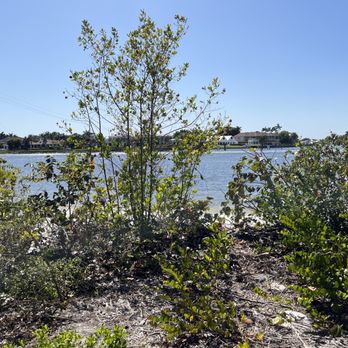
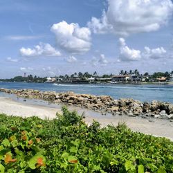
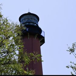
Beautiful nature preserve along the trail on the concrete you can see different animal foot prints. As you walk there is a mix of vegetation from coffee bean, cabbage palms, medicinal plants, edible cactus, coco plum and sea grape. Walking along the way you will come into the intercostal area and see the bridge as well as the light house. This walk takes about 45 minutes and you can sit on the bench to take in the sights if you get tired. We could see a few people bathing along the shore line. There is no bathroom on this trail and if your thirsty best to bring your water with you. Parking is no problem.

4 years ago
I've been wanting to visit this ERM park ever since visiting its neighbor, Juno Dunes Natural Area. The last time I tried to visit, the very small parking lot was full. From the road, this park looks to be all scrub, but like the other park, it contains multiple habitats inside. The first paved walk leads to a very nice pavilion overlooking the River. The view was peaceful and beautiful. Trying to access the unpaved trails, however, proved problematic. We turned onto the red path, only to find that the marker stakes had most of the red faded away and were difficult to find. At one point there is a huge fork in the path with no direction on which way to go. The end of the trail is practically non existent, with no clear path, but it does return us to the park entrance. I insisted on trying to get to Ski Beach- whatever that was! It looked about a 1/3 the way of the yellow trail. The path was very sandy, and difficult to walk on for that reason, and it seemed to take forever! When we finally found Ski Beach, we found another Park kiosk, a garbage can, and a tiny path down to... a beach! and the Intracoastal. We watched fish swim by, and lots of boats go by. This could be a nice place to wade or further explore, if you lugged all of your things here. ERM, would have loved finding a bench here, so we had someplace to take our shoes on and off. We did not continue down the yellow trail due to being exhausted, but I would like to do this again. The landscape was nice- just difficult to walk in due to the white sand. We saw a cactus in bloom, a snake, and a TON of lichen. Lichen everywhere! It really looked like little fairy landscapes to me. I think I finally identified Florida rosemary too! Kudo to ERM for the map/brochures. My kids pore over every aspect of it while we walk, trying to find all the natural items pictured, excitedly matching the pictures to plants. Thank you! read more


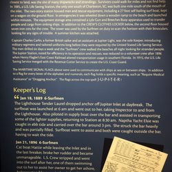
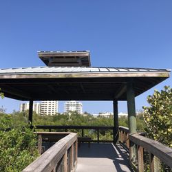
Jupiter Ridge is located south of the Jupiter inlet. It is part of the Great Florida Bird and Wildlife Trail. This natural area is made up of 274 acres of scrub that contain five native Florida ecosystems: scrub, scrubby flatwoods, mesic flatwoods, depression marsh and mangrove swamp, It is one of the few places you can go in Jupiter to see how Florida looked before it was developed. Thirty one plant species live here as well as threatened and endangered species like the large-flowered rosemary, the Florida scrub-jay; and the gopher tortoise. Jupiter Ridge is owned by the state Conservation and Recreation Lands project which is managed by Palm beach County. This natural area has the longest shoreline along the Atlantic Intracoastal Waterway of any other natural area in Palm Beach County. There is also 7,600 feet of water frontage along the Intracoastal Waterway along the Loxahatchee River/Lake Worth Creek Aquatic Preserve. There are three hiking trails, the paved Little Blue Heron Trail, (0.2 miles), the sand Scrub Lizard Trail (1.7 miles). and the sand Pawpaw Trail (0.6 miles). The sand trails really give your legs a work out and there is no shade so the sun can be brutal. The natural area has canoe and kayak access from Ski Beach and you may be able to spot manatees. There is also an observation platform on the Little Blue heron Trail that overlooks Old Lake Worth Creek. Jupiter Ridge Natural Area is open to the public, sunrise to sunset, seven days a week. read more


Another wonderful park that I suggest that you all that love nature walks and discovering new plants and animals, this park should be on your to do list. This park has plenty of shrub on dunes along with interesting insects such as Halloween Pennant. Unfortunately, we did not find any wild life such as reptiles, river otters, and also did not see any grey foxes. That might have been a good thing. read more


Beautiful nature preserve along the trail on the concrete you can see different animal foot prints. As you walk there is a mix of vegetation from coffee bean, cabbage palms, medicinal plants, edible cactus, coco plum and sea grape. Walking along the way you will come into the intercostal area and see the bridge as well as the light house. This walk takes about 45 minutes and you can sit on the bench to take in the sights if you get tired. We could see a few people bathing along the shore line. There is no bathroom on this trail and if your thirsty best to bring your water with you. Parking is no problem. read more


3 years ago
This natural area is located right off US1. Finding it was very easy. There is plenty of parking. We visited on an overcast day and were able to really enjoy the walk because it was nice and breezy. Some areas have a boardwalk and cross over swamp land, others are dunes and you walk through the sand. We saw fox footprints in the sand! The area is always open. There is a board near the entrance with information on the plants and animals you may find the area. We saw a gopher tortoise and plenty of birds. We also saw crabs, spiders, mushrooms and beautiful flowers. Keep your eyes open! There is no entry fee, there is a donation box. I really enjoyed the area that overlooked the water. read more


7 years ago
8 years ago
10 years ago
More info about Jupiter Ridge Natural Area
1800 South US Hwy
Jupiter, FL 33477
Directions
Hours
Outdoor Amenities
Ask the Community - Jupiter Ridge Natural Area
You might also consider


Jupiter Ridge Natural Area - hiking - Updated July 2026
Best of Jupiter
People found Jupiter Ridge Natural Area by searching for…
Trending Searches in Jupiter, FL
Beach Equipment Rentals near Jupiter Ridge Natural Area
Black Owned Nail Salons near Jupiter Ridge Natural Area
Boardwalk near Jupiter Ridge Natural Area
Cliff Jumping near Jupiter Ridge Natural Area
Day Trips near Jupiter Ridge Natural Area
Dog Friendly Beaches near Jupiter Ridge Natural Area
Dog Friendly Trails near Jupiter Ridge Natural Area
Historical Sites near Jupiter Ridge Natural Area
Jet Ski Rental near Jupiter Ridge Natural Area
Kayak Rental near Jupiter Ridge Natural Area
Lakes & Ponds near Jupiter Ridge Natural Area
Landmarks & Historical Buildings near Jupiter Ridge Natural Area
Off Road Trails near Jupiter Ridge Natural Area
Outdoor Activities near Jupiter Ridge Natural Area
Parks For Picnics near Jupiter Ridge Natural Area
Places To Swim near Jupiter Ridge Natural Area
Places To Visit near Jupiter Ridge Natural Area
Places To Walk Around near Jupiter Ridge Natural Area
Pool Day Pass near Jupiter Ridge Natural Area
Public Art near Jupiter Ridge Natural Area
Public Shower near Jupiter Ridge Natural Area
Public Swimming Pools near Jupiter Ridge Natural Area
River Swimming near Jupiter Ridge Natural Area
Rock Quarry near Jupiter Ridge Natural Area
Scenic Night View near Jupiter Ridge Natural Area
Scenic Overlook near Jupiter Ridge Natural Area
Scenic Restaurants near Jupiter Ridge Natural Area
Secluded Spots near Jupiter Ridge Natural Area
Sightseeing near Jupiter Ridge Natural Area
Soccer Store near Jupiter Ridge Natural Area
Sunrise View near Jupiter Ridge Natural Area
Swimming Holes near Jupiter Ridge Natural Area
Swimming Lakes near Jupiter Ridge Natural Area
Things To See near Jupiter Ridge Natural Area
U Pick Farms near Jupiter Ridge Natural Area
Browse Nearby
BEST of Jupiter, Florida Coffee near Jupiter Ridge Natural Area
BEST of Jupiter, Florida Restaurants near Jupiter Ridge Natural Area
BEST of Jupiter, Florida Walking Trails near Jupiter Ridge Natural Area
BEST of Jupiter, Florida Things to Do near Jupiter Ridge Natural Area
BEST of Jupiter, Florida Breakfast near Jupiter Ridge Natural Area
BEST of Jupiter, Florida Parks near Jupiter Ridge Natural Area
BEST of Jupiter, Florida Campgrounds near Jupiter Ridge Natural Area
BEST of Jupiter, Florida Day Trips near Jupiter Ridge Natural Area
BEST of Jupiter, Florida Boat Cruise near Jupiter Ridge Natural Area
Browse Brands
Related Searches in Jupiter, FL
Affordable Kayak Rental Services in Jupiter, Florida
Best Dog Hiking Trails Around Jupiter, Florida
Best Fishing Locations and Guides in Jupiter, Florida
Best Lookout Points to Visit in Jupiter, Florida
Best Nature Trails for Hiking in Jupiter, Florida
Best Places for Horseback Riding in Jupiter, Florida
Best Sightseeing Experiences Available in Jupiter, Florida
Book Engaging Historical Tours in Jupiter, Florida
Check Out Off Road Trails in Jupiter, Florida
Discover Charming Historic Homes in Jupiter, Florida
Discover Dog Friendly Trails to Explore in Jupiter, Florida
Discover Famous Monuments in Jupiter, Florida
Discover Historic Sites and Places in Jupiter, Florida
Discover Popular Bike Trails in Jupiter, Florida
Discover Popular Landmarks in Jupiter, Florida
Discover Popular Photo Spots in Jupiter, Florida
Discover Scenic Beach Camping Sites in Jupiter, Florida
Discover Scenic Mountain Bike Trails Near Jupiter, Florida
Discover Top Nature Parks to Visit in Jupiter, Florida
Discover a Hiking Trail in Jupiter, Florida
Discover the Best Fishing Lake in Jupiter, Florida
Discover the Best Military Museum in Jupiter, Florida
Discover the Best Night Hike Trails in Jupiter, Florida
Dog-Friendly Hikes With Dogs in Jupiter, Florida
Enjoy Camping Adventures Around Jupiter, Florida
Enjoy Kayaking Adventures in Jupiter, Florida
Enjoy Off Leash Dog Hikes in Jupiter, Florida
Enjoy Scenic Places to Walk in Jupiter, Florida
Enjoy Tent Camping Spots Around Jupiter, Florida
Enjoy the Best Night View Spots in Jupiter, Florida
Enjoy the Best Walking Trails in Jupiter, Florida
Experience Stunning Sunset Views in Jupiter, Florida
Explore Beautiful Botanical Gardens in Jupiter, Florida
Explore Beautiful Castles and Landmarks in Jupiter, Florida
Explore Beautiful Parks and Green Spaces in Jupiter, Florida
Explore Children's Museums Near Jupiter, Florida
Explore Easy Hikes Perfect for All in Jupiter, Florida
Explore Free Things to Do Around Jupiter, Florida
Explore Fun Activities to Do in Jupiter, Florida
Explore Picnic Parks Near Jupiter, Florida
Explore Popular Campgrounds Near Jupiter, Florida
Explore Popular Dog Walking Trails in Jupiter, Florida
Explore Popular Scenic Overlook Points in Jupiter, Florida
Explore Popular Scenic Views Near Jupiter, Florida
Explore Popular State Park Destinations in Jupiter, Florida
Explore Secret Spots Worth Visiting in Jupiter, Florida
Explore Top Art Galleries Located in Jupiter, Florida
Browse Articles
People who viewed Jupiter Ridge Natural Area also viewed
SWA Greenway Trail System
3 reviews
Peck Lake Park
6 reviews
Hawks Hammock Preserve
1 review
Jupiter Inlet Lighthouse Outstanding Natural Area
2 reviews
Jupiter Inlet Shipwrecks
3 reviews
Apoxee Wilderness Trail
15 reviews
Northwood Village
1 review
St Lucie Lock and Dam
1 review
Mount Elizabeth Mound
1 review
Jimmy Graham Park
3 reviews