Cancel

    Open app

    Search

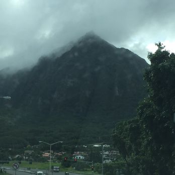
    Koolau Mountain Range

    5.0 (1 review)

    Koolau Mountain Range Photos
    You might also consider

    Recommended Reviews - Koolau Mountain Range

    Your trust is our priority, so businesses can't pay to alter or remove their reviews. Learn more about reviews.
    Yelp app icon
    Browse more easily on the app
    Review Feed Illustration

    1 month ago

    Helpful 8
    Thanks 3
    Love this 7
    Oh no 0

    You might also consider
    Verify this business for free

    People searched for Hiking 3,866 times last month within 15 miles of this business.

    Verify this business

    Pu'u Ma'eli'eli Digging Hill

    Pu'u Ma'eli'eli Digging Hill

    4.6
    (116 reviews)
    1.0 km

    It's been a few years since I've been on this hike... It was a total of about 2.6 miles up and down…read morebecause we took a side path to come down. So rather than winding back-and-forth, we came straight down and ended up near the tennis courts of the townhouses below. Park on Hui Iwa and meet at the McDonalds at the corner of Kahekili and Hui Iwa. Then walk along the highway opposite Temple Valley until you see a path going up -that's the start of the unmarked trail. Overall shady, short but with enough climbing to get in some cardio. You'll be rewarded with gorgeous Ko'olau Mountain Views and ALL of Kaneohe Bay! Excellent short hike with bay view rewards!

    Easy-ish to moderate hike, depending obviously on your fitness level and hiking acumen. No…read morewaterfall at the end, but you're rewarded with a spectacular vista of the Kaneohe Bay area. To get to the trailhead, park on the street preferably or in the shopping area across the street (where the McDonald's is). You can chance it there, but you should be good. Very popular hike, so go early to avoid crowds. So from the shopping center or wherever, follow the guard rail alongside the highway. The beginning of it is at the corner of the road going up to the shopping center. I'd suggest not walking on the right side of the guard rail as it puts you perilously close to oncoming traffic. So hop the guard rail on the left side and follow the really narrow dirt path that leads to the end of the guard rail. To the left, you'll see a sign that says "private property - no trespassing." Ignore that, obviously, and head up the path behind it. It's an in then back the way you came from hike; not sure if it's a loop, but it's about 2 or so miles round trip. The first 1/8th is steep and muddy, with slick, clay ground. Nice people have left ropes on the side so you can use that to get up. The rest of the way is shaded, with rooted paths, lots of local fauna and lots of bugs, too. The last part right before the pillboxes is a very steep incline. Again, there's rope there to help you up if you're not a ninja like I am. First bunker is kinda cool. You can climb down the rusty but stable ladder and get a nice view from the inside. The second one is where you want to be. It's where all the Instagramers are at taking selfies. If you're lucky enough to be there alone, you'll have a nice, meditative moment where you can see the bay. Good hike that's not too hard at all.

    Photos
    Pu'u Ma'eli'eli Digging Hill
    Pu'u Ma'eli'eli Digging Hill
    Steep and slick. You can do it!

    See all

    Steep and slick. You can do it!
    Friendship Garden

    Friendship Garden

    4.4
    (74 reviews)
    2.3 km

    Friendship Garden has 72 reviews as of 1/17/2025 and I was wondering why. I think the name explains…read moreit. It's a short, garden trail inside a neighborhood rather than a real hike. As I was walking this trail, my brain is telling me this is a mini Aiea loop trail with great view of the Windward side of Oahu. Parking is a challenge. The location is inside, one way, Kokokahi Place neighborhood so there's only street parking. We were lucky to find spacious area to park. The view here is great considering we only hike up 20-30 minutes. Total trip length was 2 miles. That was little disappointing because I like to get most out of my hikes. I feel like I got ripped off on this hike with little sweat. As for intensity, you do have to climb up but lots of ropes to help you. Luckily it was a dry day so no mud. This trail is quite narrow so it may not be kid friendly. Also, if you're on the taller side, watch out for branches. This is not State trail so it seems like it's not kept up regularly.

    If you need an escape from daily life to catch a breath and rekindle friendships, then the…read moreFriendship Garden is the perfect place. This is a very short hike that loops around, so you shouldn't be running into anyone on the narrow pathway. Start right, like driving! There's nothing steep, treacherous, or difficult. The Friendship Garden is very well maintained. Maps and information are provided at the beginning. At the top, you'll find beautiful views Kaneohe Bay. There's also a pathway that leads to another hike that's clearly more difficult and not apart of the Friendship Garden. Warning signs posted! The only difficult thing might be finding this place because it's quite hidden, deep in a residential area. It's located on Kokokahi Pl, which you can reach from Kaneohe Bay Dr. Just drive all the way up, and it'll be to your left. You can only park along the side of the road. Make sure to leave enough space, and also be mindful of the signs! No parking from 6-11AM on Wednesdays and Saturdays, which is probably trash pick up days. Overall, a really nice, easy hike with well maintained pathways. It might be a journey to get there, but it's worth it. Bring friends and make new friends!

    Photos
    Pretty and rare
    Pretty and rare
    Cony's birthday was spent with her best friends - Brown and Choco!
    Cony's birthday was spent with her best friends - Brown and Choco!
    Someone's house is right below

    See all

    Someone's house is right below
    Likeke Falls

    Likeke Falls

    4.3
    (127 reviews)
    3.9 km

    I've have made this short hike a few times, today the falls were flowing more than the other times…read more It was so peaceful and beautiful to see so much water flow. Trail was a little muddy in spots but not bad. There was a tree across the trail right by the area that you take the trail to the right to head to the falls. There is some ups and downs, high steps ups, lots of roots, so keep your eyes on the trail. Alltrails is helpful to stay on trail.

    Nice woodsy falls a reasonably easy hike up through the jungle. Hiking from the road to the golf…read morecourse parking lot adds about a half mile and is as long or longer than the jungle hiking. The falls are maybe 30 feet high down the rock face. If you go up to the base there is a pool deep enough to dip all the way into, with some lower pools just deep enough for a foot soak. The trailhead is on the far left side of the golf course parking lot as you come up from the road. The trail is wide to start, then just before you hit the big water tank the trail goes off and up to the left. A little ways in there are two big downed trees, and the trial to the falls takes a hard turn to the right. Straight/left goes away from the falls but there are a bunch of trees across the trail a half-mile or less down the trail. The falls trail continues down the farthest left fork below the falls. You follow the blue and pink ribbons, and eventually they split. The pink goes down along the streambed. The blue seemed to go up the streambed and involves some serious rope climbing, but then I lost the trail and couldn't see any more blue ribbons.

    Photos
    Just hanging around!
    Just hanging around!
    Still going...
    Still going...
    Getting there...

    See all

    Getting there...
    Hamama Falls

    Hamama Falls

    4.0
    (12 reviews)
    7.7 km

    I don't hike a lot but friends wanted to go so we did the trek. Another friend who hikes a LOT told…read moreme it's one of the most beautiful hikes he's been on. While I don't have a large amount of destination spots to compare, I do have my share of hiking experiences. It really was beautiful. So many picturesque spots. Got some great photos on the way up to the falls. Be sure to have good footwear as it can get pretty slippery. While most of the path is graveled, there are numerous areas where you could easily fall. If you're a mosquito magnet, put your bug spray on before you start the hike and take it with you. I still came out with a bunch of bites, mainly cause my sweat washed some of the protection off. Had a great time. Highly recommend.

    We went on a Friday morning; thankfully no police there that day to stop us. A friend tried to go…read morethe next morning - you guessed it, popo were there and stopped all hikers from accessing the trail. For us, though, another great hike up to the falls. Very few people during the week so no fighting for space at the falls. And after the walk up it sure felt great to stand under the falls and cool down. Definitely one of my fav waterfalls on Oahu and, if not blocked by the popo, a really easy 45 minute trek up. Yes, it is technically trespassing since the trail/falls is on BWS property. Apparently loud groups of hikers have pissed off the neighbors so the police now routinely patrol the gate area. Sure hope this doesn't go the way of Haiku Stairs and get permanently closed down.

    Photos
    Bunker looks like it was in Jurassic park movie
    Bunker looks like it was in Jurassic park movie
    Little waterfall before hamama
    Little waterfall before hamama
    Hamama falls!

    See all

    Hamama falls!
    Lulumahu Falls

    Lulumahu Falls

    4.5
    (360 reviews)
    5.6 km

    A beautiful day for a hike! Every time I do this hike it's a little different. Today the waterfall…read morewas cold and bracing and there were a lot of people hiking the falls. We started out around 8:45 AM and by the time we reached the waterfall, it was getting full of families and pairs of hikers. I recommend go early to skip the crowds. The hike itself isn't too technical and there are only a few places where you have to step up high over a rock or scramble through a stream.

    Lulumahu Falls was definitely one of the hikes I've wanted to do for a very long time…read more I've passed by it a number of times, so I knew exactly where it was. If you've driven up Pali Hwy - Kailua-bound, then you've passed by it. The parking and entrance is right at the intersection of Nuuanu Pali Road, you'll see plenty of cars parked. While there's no true entrance, cars do somehow figure out a way to park. You technically do need a permit to visit here as you are accessing State Forest Reserve land, which you can purchase at - https://trails.ehawaii.gov/camping/ - website. It's very easy to set up an account and make your reservation. It's only $2.50 for your entire party (not per person!). Print at least two copies (1 for your car and 1 with you). This hike is not as easy as a good amount of reviews make it out to be. It's not that kid friendly either. The main entrance is at the center of the parking lot. There is also another entrance to your right, near the road. The beginning part is fine. Flat and well maintained, graveled path through a bamboo forest. It's after your first jump or hop over a streamlet that can be more difficult because the hike is essentially gradually going up towards the mountain while crossing over the Lulumahu Stream multiple times until you reach the waterfall. Crossing the stream, you'll need to jump or climb from rock to rock, go under tree branches, step on slipper rocks (or just step in the water), and etc. You shouldn't get lost here as long as you hear the stream and stay near it. The objective is to follow the stream while looking out for those bright neon ribbons. But there are situations where you don't see any ribbon with multiple paths you can take. Being that it was my first time here, I probably took a few paths that was the more difficult one, but eventually made it at the end without any difficulties or setbacks. This seems to be a popular hike as it was quite busy at the waterfall. There were hardly any places to stand, and the "safe" areas are further away from the waterfall while if you want to get closer to get that under the waterfall photo, you'll need to pass some slippery rocks, jump here and there, and pass through narrow spaces. Of course, you can just put your shoes and feet into water to bypass. In the end, it was quite a nice waterfall and an interesting journey to get there. Wish it was less busy, but it wasn't overcrowded. There's no main path, so you can end up going through many difficult paths. I can upon a family of 4 literally walk up the stream, knee high in water. No clue where they came from, but I pointed to the direction I went. On the way down, you can take a different path. I went towards the right, and went down to the watershed. Look for the cement wall with graffiti. You can keep going down the walkway, and there is an opening at the corner of the fence towards the end, which will lead you back to the beginning, bamboo forest path. Overall, this was a fun and interesting hike! It wasn't easy, but not difficult or long. A good test of your balance to not get your socks wet! It takes about 45-60 minutes both ways depending on your level and path taken. Unless you want to swim and climb up stream. Hope to come back soon!

    Photos
    Lulumahu Falls
    Crossing through the stream - hopping on the rocks
    Crossing through the stream - hopping on the rocks
    Enter here

    See all

    Enter here
    Oneawa Hills

    Oneawa Hills

    4.2
    (17 reviews)
    2.3 km

    Nice hike with shade for the most part, trail becomes steep but has ropes to help…read more Lots of roots and uneven footing so watch your step. The California grass is tall and sharp, needs to be cut back. My friends and I have lots of little cuts on our arms from it. Also beware of bees! Bring you Benadryl or epo pen if you need, they sting one of us in the face as we were walking through the tall grass. This might not be a long hike but due to incline and climb up it is a good hike to get a good workout in. The view also did not disappoint, AMAZING!!!! As you go up of course they just get better and better. We are all so glad we finally made it to this hike!!! Parking is tight! And you are in a neighborhood, where you do not want to block there parking, only room for 3-5 cars smaller cars at one time. Love the friendship garden part of the hike with the gorgeous plants and trees that have species placards.

    Not my favorite...kind of strenuous, with nice, but not necessarily breathtaking views…read more I had this hike on my list for a while now, so when friends suggested we go, I was up for it. Parking seemed limited, but I drove past the trailhead down to a section of the neighborhood that had a number of spaces. It was probably about an 8 minute walk back up to the trailhead. It starts easy, with much forest greenery, and several routes, that will take you on the Oneawa path. I guess I hadn't mentally prepared, but was surprised by the incline and the ropes. Perhaps my lack of uppers that morning was to blame, as I not expecting this to be difficult, but I was struggling to keep up with my friends as the hike continued. It took us about an hour to see the quarry waters, which were interesting, but only needed a few minutes to take in. You do get some nice views of the bay and it's not a very long hike, so there is that, but I honestly don't think I'd come back. It felt like more effort than it was worth and there are so many other hikes on Oahu that unless I lived RIGHT there, I don't think it warrants another go.

    Photos
    View looking towards Kailua.
    View looking towards Kailua.
    Oneawa Hills
    Oneawa Hills

    See all

    Hungaro Explorer

    Hungaro Explorer

    5.0
    (10 reviews)
    1.9 km

    Nandor the Explorer!!! What more can I say about this man and his utmost professionalism. He was in…read moreconstant communication with us from booking through to the beginning of our hike up the Moanalua Trail. We were worried about the rainy weather but Nandor told us not to worry and I'm glad we trusted him because even though our hike began with a downfall, it cleared up and switched between cloudy/misty and sunny. The weather was perfect for the hike because if it was all sunny, I think it would've been too hot. Only thing was it was extremely muddy but fear not, our guide came prepared. He has spikes for us as well as extra rope since somehow all of the normal ropes that were supposed to be on the trail were cut down or removed. He was very knowledgeable and friendly. If you need recommendations for other trails basically anywhere, this is your man! He's been around so many places and has hiked and explored almost all the places I could think of. I'm pretty sure I would've fallen off the ridges or slipped and tumbled my way to certain injury if it weren't for his guide and ensuring our safety. One bonus thing, the guy takes AMAZING pictures for you on his professional camera. So don't even worry about using your phone, he's got you covered! Thanks Nandor, I shall come to you the next time I want to explore Hawaii's secluded gems!

    Nandor provides a world-class experience every time. I have had the pleasure of hiking 4 trails in…read moreOahu with Nandor and each have been difficult, exciting, and a memorable experience. I would highly recommend him as a guide for any level of experience hiker as he personalizes your adventure. He never packs multiple groups together but rather offers a private experience for you and your group. He is an easy companion and good conversationalist, which is important if you're out for a 4-5 hour hike. Utmost professionalism in that he assess your capabilities, keeps a watchful eye, yet encourages you to accomplish things you didn't expect you ever would. He understands the weather and geography of Hawaii. Watch his youtube videos from Hungaro Explorer to see what kind of fun awaits.

    Photos
    Nandor on a trail running mission
    Nandor on a trail running mission
    Nandor with his client
    Nandor with his client
    Nandor and his hiking group

    See all

    Nandor and his hiking group
    Olomana Hike

    Olomana Hike

    4.8
    (240 reviews)
    4.8 km

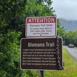
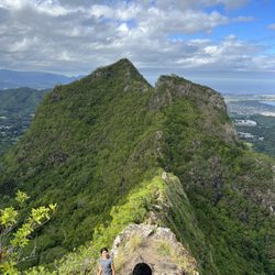
    This is not for the faint of heart. First peak is an hour and a half of serious cardio. Rope…read moresections and rapid, steep elevation. Pic is from second peak. Don't forget to bring enough water and snacks.

    Tl:dr: the most technically challenging hike on the island, takes 5-6 hours round trip including…read morestops on each of the 3 peaks to take pictures, rest etc. People talk about mortality on this trail, although I don't think it's as dangerous as people made it out to be if you exercise common sense. Who should do it: most people can make the 1st peak. Trail from 1st to 2nd becomes noticeably narrower but it's short and about the same level of difficulty as trail up the 1st peak. 2nd to 3rd peak was where the challenge is - lots of vertical rock climbing, path is narrow, and ropes aren't all in good conditions. If you don't have good upper body strength, have knee problems, or are afraid of heights, it's not a good idea to do the 3rd peak. If you don't have good endurance, it's just going to be a long day. Words of caution: try avoid going after a rainy day because the trail becomes very muddy. It started raining when I was coming down from the 3rd peak and the ground became slippery. Better to go with a friend if you can - there are only a few people hiking past the 2nd peak and in case you get injured, it's good to have someone with you to help. Preparation: pack enough water, gloves (protect your hands from climbing), long pants, and a light windbreaker (waterproof is ideal). You never know how the microclimate changes in the mountain. Throw on some hiking shoes too if you have them. You can get away with gym shoes as I did but extra grip comes in handy on a muddy day. Views: view is the best from the 1st peak. Past that is more for the adrenalin and experience. Parking: no official parking lot for the hike, park across the bridge on the side of the roads. It's a ~15 minute walk to the trailhead. Have fun out there!

    Photos
    Olomana Hike
    "I've been Here" or Geocache box and some emergency ropes
    "I've been Here" or Geocache box and some emergency ropes
    Third peak looking back at First and Second

    See all

    Third peak looking back at First and Second

    Koolau Mountain Range - hiking - Updated August 2026

    Loading...
    Loading...
    Loading...