North Cascades Visitor Center Photos


You might also consider
More like North Cascades Visitor Center
Recommended Reviews - North Cascades Visitor Center
Start your review...

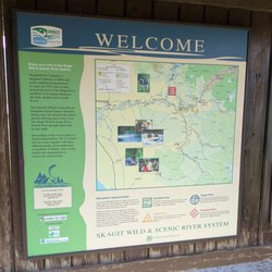
This Visitor Center is a must visit. They have map of North Cascades Mountain and Hiking Trails. There is a gift shop, restrooms, water fill stations, and gift shops There is a trail in the back of the visitor center. The River Loop Trail. An easy trail to visit where it leads into a view of the water. There is a park ranger there available to answer your questions on what trails is open and what is accessible. The Visitor Center is a place where you can relax a little and enjoy the information of maps available to many. There is an exhibit available by the gift shop. The gift shops has various items. Tshirts, magnets and postcards. They sell a little bit of snacks too. read more


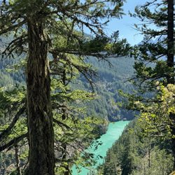
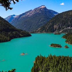
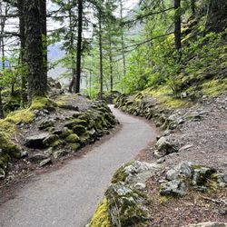
Since North Cascades is one of the least visited national parks, I wasn't expecting much from their visitor center. However, it's actually super nice - so pleasantly surprised. Decent sized center. Small bookstore with a good variety of souvenirs. Lots of park information. Super knowledgeable rangers ready to help with your visit. Really nice and clean bathrooms (always a big plus!!). We had cell reception here so it was great to plug our stops in on maps. Make sure to walk around to the back of the visitor center. There's a short boardwalk that's ends with a gorgeous viewpoint of North Cascades. Hands down a must. You can take as little or as much time as you want just enjoying the beauty. The visitor center is also the starting point for the River Loop Trail - an easy 1.8 mile round trip walk with beautiful views of the surrounding forest and the river. Great first stop for your trip to North Cascades. read more

The North Cascades Visitor Center is a great place to stop before you make it to your first trailhead. The staff is friendly, the center is clean and the surrounding area is well maintained. When I stopped this weekend, they had a staff member dedicated to sharing interesting info about the various mammals that live at the national park. They have bear skins, silicone bear paw molds and so much more. Make sure you grab a free map of the park. It is really helpful because you won't have any internet connection to get your maps app open. They also sell tons of goodies like the branded hats, stickers, art, shirt, hoodies and so much more. There's also a film you can watch in their theater about the park and surrounding area. P.s. ask how you can sign up for their online newsletter!! You'll get two beautiful stickers as a gift for signing up. read more

3 years ago
This is a great place to visit. The scenery is amazing, and one of the few restrooms in the area (the restrooms are very clean). If you have children, they can watch a short presentation and get their junior ranger badge. read more


3 years ago
More info about North Cascades Visitor Center
Ask the Community - North Cascades Visitor Center


North Cascades Visitor Center - parks - Updated June 2026
Best of Marblemount
People found North Cascades Visitor Center by searching for…
Things to Do in Marblemount, Washington
Hiking Trails With Waterfalls in Marblemount, Washington
River Swimming in Marblemount, Washington
Visitor Centers in Marblemount, Washington
Sunset View in Marblemount, Washington
Watch Sunset in Marblemount, Washington
Playgrounds in Marblemount, Washington
Scenic Overlook in Marblemount, Washington
Dog Hiking Trails in Marblemount, Washington
Boardwalk in Marblemount, Washington
National Parks in Marblemount, Washington
Swimming in Marblemount, Washington
Lookout Points in Marblemount, Washington
Dinosaur Park in Marblemount, Washington
Redwood Trees in Marblemount, Washington
Easy Hikes in Marblemount, Washington
Tent Camping in Marblemount, Washington
Walking Trails in Marblemount, Washington
Sightseeing in Marblemount, Washington
Must See in Marblemount, Washington
Picnic Tables in Marblemount, Washington
Family Fun in Marblemount, Washington
Trending Searches in Marblemount, WA
Boat Rental near North Cascades Visitor Center
Fishing Spots near North Cascades Visitor Center
Lakes near North Cascades Visitor Center
Parks near North Cascades Visitor Center
Pick Your Own Farms near North Cascades Visitor Center
Picnic Areas near North Cascades Visitor Center
Splash Pad near North Cascades Visitor Center
Swimming Holes near North Cascades Visitor Center
Browse Articles
Browse Nearby
BEST of Marblemount, Washington Things to Do near North Cascades Visitor Center
BEST of Marblemount, Washington Coffee near North Cascades Visitor Center
BEST of Marblemount, Washington Hiking near North Cascades Visitor Center
BEST of Marblemount, Washington Restaurants near North Cascades Visitor Center
BEST of Marblemount, Washington Breakfast near North Cascades Visitor Center
BEST of Marblemount, Washington Campgrounds near North Cascades Visitor Center
BEST of Marblemount, Washington Lakes near North Cascades Visitor Center
Browse Brands
Related Searches in Marblemount, WA
Affordable Kayak Rental Services in Marblemount, Washington
Best Fishing Locations and Guides in Marblemount, Washington
Best Nature Trails for Hiking in Marblemount, Washington
Best Parks for Parties and Events in Marblemount, Washington
Best Places for Horseback Riding in Marblemount, Washington
Best Spots for Star Gazing in Marblemount, Washington
Best Water Parks for Kids in Marblemount, Washington
Best Waterfalls and Swimming Holes in Marblemount, Washington
Check Out Great Playgrounds in Marblemount, Washington
Check Out Off Road Trails in Marblemount, Washington
Discover Baseball Fields Around Marblemount, Washington
Discover Dog Friendly Trails to Explore in Marblemount, Washington
Discover Fun Toddler Parks in Marblemount, Washington for Your Little One
Discover Lakes & Ponds to Explore in Marblemount, Washington
Discover Popular Bike Trails in Marblemount, Washington
Discover Popular Photo Spots in Marblemount, Washington
Discover Scenic Mountain Bike Trails Near Marblemount, Washington
Discover Stunning Skyline View Spots in Marblemount, Washington
Discover Top Boat Tours in Marblemount, Washington for All Ages
Discover Top Nature Parks to Visit in Marblemount, Washington
Discover a Hiking Trail in Marblemount, Washington
Dog-Friendly Hikes With Dogs in Marblemount, Washington
Enjoy Camping Adventures Around Marblemount, Washington
Enjoy Scenic Night View Experiences in Marblemount, Washington
Enjoy Tent Camping Spots Around Marblemount, Washington
Enjoy the Best Picnic Spots and Ideas in Marblemount, Washington
Enjoy the Best Walking Trails in Marblemount, Washington
Experience Stunning Sunset Views in Marblemount, Washington
Experience Thrilling White Water Rafting in Marblemount, Washington
Explore Beautiful Parks and Green Spaces in Marblemount, Washington
Explore Bike Rentals Throughout Marblemount, Washington
Explore Easy Hikes Perfect for All in Marblemount, Washington
Explore Free Picnic Areas Around Marblemount, Washington
Explore Popular Campgrounds Near Marblemount, Washington
Explore Popular Picnic Areas Around Marblemount, Washington
Explore Popular RV Parks Around Marblemount, Washington
Explore Popular Scenic Views Near Marblemount, Washington
Explore Popular View Points Around Marblemount, Washington
Explore Scenic Lakes to Visit in Marblemount, Washington
Explore Secret Spots Worth Visiting in Marblemount, Washington
Explore Top Dog Parks in Marblemount, Washington Near You
Explore Top Gyms in Marblemount, Washington Now
Explore the Best Boating Spots in Marblemount, Washington
Explore the Best Swimming Holes Around Marblemount, Washington
Family Friendly Hiking With Kids in Marblemount, Washington
Find Beautiful Views in Marblemount, Washington
Find Parks and Recreation Activities in Marblemount, Washington
Find Picnic Tables for Outdoor Fun in Marblemount, Washington