Santiago Creek Trail Photos


You might also consider
More like Santiago Creek Trail
Recommended Reviews - Santiago Creek Trail
Start your review...

8 months ago


3 years ago
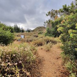
Gorgeous and manageable hike. Some steep areas for climbing but if you pace yourself, you can totally do it! While there is ample parking spots in the neighborhood, depending on when you go in the morning, you may need to wait 5-10 minutes for a spot to open up closer to the trailhead. We arrived at 10:30am and cars were parked all the way into the cul de sac. There are gorgeous green hills with native California wildflowers everywhere, including yellow mustard, mountain lupine, yellow California bush flower, and blue corn flower. The golden poppies were the most popular spots and were nestled ontop of various ridges. Pro tip: Arrive after 11:30/12 noon for easier parking. read more


2 years ago
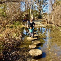
This place is amazing! It is beautiful and very busy! There's lots of trees shades. And what a beautiful creek! read more


2 years ago
1 year ago
7 years ago
More info about Santiago Creek Trail
Orange, CA 92869
Directions
Hours
Outdoor Amenities
Ask the Community - Santiago Creek Trail
You might also consider


Why does Yelp recommend reviews?
1 review that is not currently recommended
The reviews below are not factored into the business's overall star rating.
2 years ago
Santiago Creek Trail - hiking - Updated June 2026
Best of Orange
People found Santiago Creek Trail by searching for…
Hiking Trails in Orange, California
Walking Trails in Orange, California
Things to Do in Orange, California
Scenic View in Orange, California
Dog Friendly Hiking Trails in Orange, California
Places to Walk at Night in Orange, California
Easy Hikes in Orange, California
Places to Walk Around in Orange, California
Fall Foliage in Orange, California
Bike Paths in Orange, California
Empty Parking Lot in Orange, California
Running Trails in Orange, California
Nature Walks in Orange, California
Beautiful Views in Orange, California
Hikes With Dogs in Orange, California
Things to Do at Night in Orange, California
Sunset View in Orange, California
Natural Hot Springs in Orange, California
Waterfalls in Orange, California
Shaded Hike in Orange, California
Trending Searches in Orange, CA
Black Owned Nail Salons near Santiago Creek Trail
Boat Rental near Santiago Creek Trail
Cliff Jumping near Santiago Creek Trail
Day Trips near Santiago Creek Trail
Fishing Spots near Santiago Creek Trail
Jet Ski Rental near Santiago Creek Trail
Kayak Rental near Santiago Creek Trail
Lakes & Ponds near Santiago Creek Trail
Off Road Trails near Santiago Creek Trail
Outdoor Activities near Santiago Creek Trail
Places To Walk Around near Santiago Creek Trail
Public Shower near Santiago Creek Trail
River Swimming near Santiago Creek Trail
Rock Quarry near Santiago Creek Trail
Running Trails near Santiago Creek Trail
Scenic Night View near Santiago Creek Trail
Scenic Overlook near Santiago Creek Trail
Secluded Spots near Santiago Creek Trail
Soccer Store near Santiago Creek Trail
Splash Pad near Santiago Creek Trail
Strawberry Picking near Santiago Creek Trail
Sunrise View near Santiago Creek Trail
Swimming Holes near Santiago Creek Trail
Swimming Lakes near Santiago Creek Trail
U Pick Farms near Santiago Creek Trail
Watch Sunset near Santiago Creek Trail
Browse Articles
Browse Nearby
BEST of Orange, California Coffee near Santiago Creek Trail
BEST of Orange, California Restaurants near Santiago Creek Trail
BEST of Orange, California Things to Do near Santiago Creek Trail
BEST of Orange, California Breakfast near Santiago Creek Trail
BEST of Orange, California Walking Trails near Santiago Creek Trail
BEST of Orange, California Parks near Santiago Creek Trail
BEST of Orange, California Hot Springs near Santiago Creek Trail
BEST of Orange, California Campgrounds near Santiago Creek Trail
BEST of Orange, California Sightseeing near Santiago Creek Trail
Browse Brands
Related Searches in Orange, CA
Affordable Kayak Rental Services in Orange, California
Best Fishing Locations and Guides in Orange, California
Best Nature Trails for Hiking in Orange, California
Best Places for Horseback Riding in Orange, California
Check Out Off Road Trails in Orange, California
Discover Dog Friendly Trails to Explore in Orange, California
Discover Kid Friendly Hiking Trails in Orange, California
Discover Scenic Hiking Trails in Orange, California
Discover Scenic Mountain Bike Trails Near Orange, California
Discover Scenic Waterfall Spots in Orange, California
Discover Top Nature Parks to Visit in Orange, California
Discover Walking Parks in Orange, California Near You
Discover a Hiking Trail in Orange, California
Discover the Best Night Hike Trails in Orange, California
Dog-Friendly Hikes With Dogs in Orange, California
Enjoy Camping Adventures Around Orange, California
Enjoy Exciting Mountain Biking Adventures in Orange, California
Enjoy Kayaking Adventures in Orange, California
Enjoy Tent Camping Spots Around Orange, California
Enjoy a Beautiful Waterfall Hike in Orange, California
Enjoy a Peaceful Nature Walk in Orange, California
Enjoy the Best Walking Path in Orange, California
Enjoy the Best Walking Trails in Orange, California
Exciting Cliff Jumping Spots in Orange, California
Explore Beautiful Parks and Green Spaces in Orange, California
Explore Easy Hikes Perfect for All in Orange, California
Explore Popular Campgrounds Near Orange, California
Explore the Best Beach Spots in Orange, California
Explore the Best Swimming Holes Around Orange, California
Explore the Best Trail Options in Orange, California
Family Friendly Hiking With Kids in Orange, California
Find Beautiful Views in Orange, California
Find the Best Parks for Picnics in Orange, California
Find the Best Scenic View Locations in Orange, California
Great Places to Walk in Orange, California
Hike the Popular Waterfall Trail in Orange, California
Hiking Trails With Waterfalls in Orange, California
Off Leash Dog Hiking Trails in Orange, California
Plan a Scenic Drive Route Near Orange, California
Popular Outdoor Activities to Try in Orange, California
Popular Picnic Spots to Visit in Orange, California
Safe River Swimming Areas in Orange, California
Safe and Fun Parks for Kids in Orange, California
Top Climbing Spots and Gyms in Orange, California
Top Paddleboarding Activities in Orange, California
Top Running Trails to Explore in Orange, California
Top Swimming Lakes to Enjoy in Orange, California
Top Swimming Spots and Pools in Orange, California
People who viewed Santiago Creek Trail also viewed
El Modena Open Space
41 reviews
Santa Ana River Trail
117 reviews
Weir Canyon Trailhead
19 reviews
Peters Canyon Regional Park
335 reviews
Bommer Canyon
66 reviews
Juanita Cooke Greenbelt & Trail
80 reviews
Shady Canyon Trail
40 reviews
Quail Hill Trailhead
160 reviews
Pelanconi Park
11 reviews
Hiltscher Park
38 reviews