Pine Knot Trail Photos


You might also consider
More like Pine Knot Trail
Recommended Reviews - Pine Knot Trail
Start your review...

Reviews With Photos

You need an Adventure Pass for the lot, but you may there are some limited street parking. Thee as some picnic tables at the beginning of the hike. I hiked 2 miles of this with a toddler so it took a while, but the partial shade was nice. I also hiked most of the 6+ miles but wasn't quite sure if we ended up at the Grandview point. There are some split trails so it was good to have a navigation app running to check if we were on the right trail. Would return for future hikes.

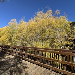
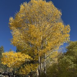
One of my favorite hikes in the area. We parked in the picnic area parking lot. There are plenty of spaces to park and restrooms to use. We were here in mid October and many of the leaves were changing to a beautiful yellow gold. It's my favorite time of year... still warm enough during the day and the air is so crisp. The pine cones have started to fall off many of the trees. This hike if you do the full trail, will take about 3 to 3.5 hours round trip. The trail is well manicured and easy to walk on. However, there are a few steep parts. (huff and puff) Be sure to take water with you and I hope you enjoy it as much as I did! Happy trails!

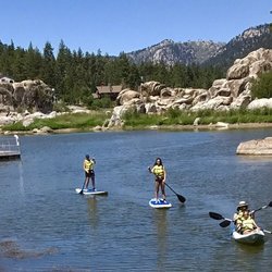
Park in the aspen glen picnic area but make sure to have a parking permit in your car! When we were leaving a bunch of cars had tickets, so make sure to prevent that by getting the adventure parking pass. It's only $5.50 and you can get it at a handful of stores around town. The trail is marked well with signage and blue indicators on trees as you go. You get beautiful views of the lake as you go higher through the trail. I wore regular athletic shoes and felt fine on the hike. Would definitely recommend for a quick hike in big bear!

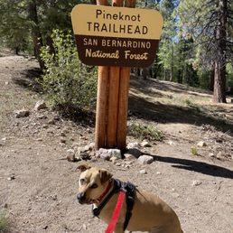
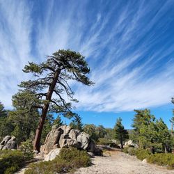
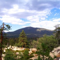
A trail that highlights NOT Big Bear Lake but the San Bernardino National Forest. Step 1: Purchase a $5 Adventure Pass or other pass like the National Park Service annual pass. Step 2: Park in the Aspen Glen Picnic Area lot on Mill Creek Road. Step 3: Use one of multiple trailheads in the picnic area. Keep wandering uphill as the trails eventually converge into one - the Pine Knot Trail as marked by signs with maps. A dirt road also goes to the top, but a trail is more interesting, safer, and less dusty. Sporadic views of Big Bear Lake appear between the trees. Step 4: At 2.2 miles is a junction with the road and when things get good. Look up for a tree top growing at a 90-degree angle (see pic). Perhaps the knot in this pine is what gives the trail its name? Look down for red ant hills made with pine needles that are knee high (see pic). Pass through the Deer Group Campground with meadow which was dried out on our drought visit but likely gorgeous when green. Step 5: Cross Grand View Junction where seven pathways intersect including the Skyline Trail. The first view of the valley south of Big Bear appears. Step 6: At 3.3 miles and 900' elevation change, arrive at Grand View Point with view of the valley, the peak of San Gorgonio, and a small chunk of the Inland Empire. Not entirely "grand", the views are partially obscured by trees.

Really enjoyed this trail. It was a moderate hike that was doable for our kids and dogs. The trail offers plenty of shade and is dog friendly. We didn't make it all the way to the top (because kids), but did make it up to an area that had big rocks and a great view of the lake. Can't wait to come back and do the entire trail with the dogs!

Beautiful moderate trail with breathtaking views and plenty of lush greenery! Total of 7-8 miles round trip (depending on if you get lost or not) for a 3-4 hr hike. Despite plenty of shade along the trail, be prepared for bright/sunny patches and some steep inclines. Bring lots of water and good shoes! - Limited parking in the Aspen Glen Picnic Area Lot, but there's additional parking along the street a little bit down the road. Make sure to purchase an Adventure Pass beforehand! (You can purchase a day pass for $5 at any store along the way- bought mine at 7/11) - Very clean trail with little to no trash. - Trail markings throughout. We got a bit lost at the fork and near the end because we didn't realize the blue markings on trees were directional! To get to Grand View, carry on straight through "Adopt a Trail" and you'll pass Deer Campground. Keep following the trail straight until you see signs that veer off to Grand View. Note that Knickerbocker Rd will also loop you to View Point, but this is mostly a bike trail. - Views at the top were great and there was a shaded rocky area perfect for a picnic. I would highly recommend this hike to anyone willing to get a bit sweaty and dehydrated!

Loved this trail. You're in the middle of the forest but the trail is perfectly clear. Lots of great views and shade for resting. It is a tough hike, but a great workout. And it's dog friendly! We went without a parking pass and so we didn't use the picnic area parking. Instead we parked along the road...and no ticket. Other vehicles did the same. Will be returning, but next time we'll make the most of the nice picnic area as well.

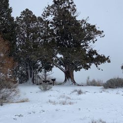
Yay! Excellent! We followed the trail directions from this site: http://nobodyhikesinla.com/2010/08/16/grandview-pointpine-knot-trail/ The trip up to the point is beautiful - pine trees, fairly well-shaded, gorgeous boulders. It was not at all crowded and my husband and I made it to the point without feeling very winded at all, even though it is a gentle incline for the most part. There are a few parts that will make you work a little more, but they are interspersed throughout. The trail, while still beautiful (and very well-maintained; directions from the aforementioned website really weren't that needed), started to get slightly monotonous a few hours in, which was also the point at which we saw signs saying that Grandview Point was near... Oh my gosh - it was an incredible view. A solid 180 degree view of San Gorgonio and the surrounding mountains and river valley; we were totally surprised and blown away by how picturesque it was. Although it's the middle of April, and CA is still in a dought - there was tons of snow on the mountains (the ones we saw from Grandview Point, not on the actual hike). Just gorgeous and totally worth any slight bit of monotony you might feel along the way. Cons: a few reckless mountain bikers, one of which was speeding around a blind corner and almost hit my husband. Parking requires a $5 adventure pass; you can get it at Bear Valley Bikes, which is at the intersection of Mill Valley Road and Hwy 18.

Hands down, my favorite hike I've done since I moved to San Diego 7 years ago. Big Bear always seemed like a little to far for a day trip from downtown San Diego, but during COVID when I'm not driving the rest of the week, and I have no big weekend plans, the 2 1/2 hour drive each way really wasn't a big deal. And the last 50 minutes of that drive is BEAUTIFUL. Mountain views, lake views, wildflowers etc! Purchased an annual adventure pass at a liquor store on the way up (I have no idea if it's required these days or not, but figured I'd grab one so I don't have to worry about the parking). There's a small lot at the trailhead, we arrived around 10:30am on a Sunday and grabbed the second the last spot. I'd imagine the lot can fill up quickly at peak times. The trail is also SUPER well marked. At any turn or split off, there was a sign of which way to go. I also had service for the majority of the hike, and checked our route on All Trails a few times. 3.5 miles to the peak, there's a place where a bunch of trails converge at about 3.3 miles where a lot of people stopped, but continue following the signs to Grand View Point another quarter of a mile, it's worth it!! The view was stunning. Sat on a rock and enjoyed my lunch, and then we hiked back, making it a little bit of a loop, which extends the trail to 8 miles instead of 6.6. I like the idea of not doing an out and back, and we got to see some different sites, but it also made the last 2 miles of the hike along a road where there were some cars driving. It definitely was a moderate to difficult hike, and it's at altitude, I was pretty much thirsty the entire time, so bring a lot of water!

The trail is about 3 miles to the top and it's a great hike if you're a beginner hiker. Not too mountainous and there's plenty of places to rest. If you're not use to elevation change I'd bring plenty of water. I'm from San Diego and I did notice it was a little harder to breathe and I got dehydrated faster. The trail is also dog friendly as long as your dog is on a leash.


We walked this trail today and while the views were beautiful I guess I should have taken a map with me. We parked at aspen park, got an adventure pass from the little green building by the road. I took my daughters with me ( age 4 and 11) and it was hard for them but it was beautiful. It's mid July and it was not hot at all. Lots of up hills and you caught views of big bear lake as you walk. But BEWARE of the mountain bikers, they come barreling down towards you and just randomly yell how many more bikes are coming. Kinda disappointing because the visitors center said there were waterfalls and there wasn't. But, it was a nice hike. The trail got thin on some spots kinda scary for my kids with the huge hills they could fall down but it was beautiful.

12 years ago


12 years ago
8 years ago
12 years ago
Great trail, took about 4 hrs total to get to grand view point and was worth it! I think it's about 6.5mi to the top and back. Get parking pass at Chrome Shop in Big Bear Lake. read more


This was a perfect hike in terms of views, difficulty, and distance. We ended up taking a wrong turn at a fork and made the hike a little bit longer but total it should be ~7 mile walk. Once we got to grand view point it was everything we were hoping for and we ate our lunch up there before heading back down. read more


9 years ago
11 years ago
Parked on a side street (free) right after the picnic area parking. We studied the map before setting on our hike and it came in handy once we were half way there because the roads do split and thankfully there are maps along the way to guide you. The scenery was beautiful, air was refreshing, and the sound was peaceful. I recommend getting there early because as the day continues you see more people and more groups. The grand view definitely is amazing but it's even better when no one else is around. read more

10 years ago
Easy hike to Grand View Point. Not difficult at all. Trail was well marked and easy to follow. We went off the trail for a while trying to find anything unusual. Found the main trail again in about an hour. read more


12 years ago
12 years ago
11 years ago
This trail had such a Beautiful View and it was so peaceful...Only noise was coming from my 13 yr old daughter and her friend who had a rough time with the climb up. Being I hike alot this trail to me was an easy to moderate I wouldnt take my 7 year old son on it because of the length of walking..I am giving it a 4 star just because we came to 2 seperate forks in the road that didnt have signs pointing you in the right direction and you could easily end up on another trail... read more

12 years ago
Pine knot trail is a good trail. Not difficult but if you're not used to exercise I would pace yourself. The path is well groomed and trees turning with beautiful fall colors. Trail is dog friendly. Fyi make sure you have a adventure pass for parking or you'll get a ticket as we did!:( its 5$ thats how much the pass is for the day. read more

10 years ago
9 years ago
12 years ago
14 years ago
11 years ago
11 years ago
12 years ago
10 years ago
10 years ago
13 years ago
8 years ago
11 years ago
12 years ago
12 years ago
11 years ago
12 years ago
Page 2 of 2
More info about Pine Knot Trail
Mill Creek Rd
Big Bear Lake, CA 92315
Directions
(909) 382-2790
Call Now
Hours
Indoor Amenities
Outdoor Amenities
Ask the Community - Pine Knot Trail
Review Highlights - Pine Knot Trail
You might also consider


Pine Knot Trail - hiking - Updated June 2026
Best of Big Bear Lake
People found Pine Knot Trail by searching for…
Things to Do in Big Bear Lake, California
Hiking Trails With Waterfalls in Big Bear Lake, California
Parks in Big Bear Lake, California
Campgrounds in Big Bear Lake, California
Fishing in Big Bear Lake, California
Places to Take Pictures in Big Bear Lake, California
Scenic Views in Big Bear Lake, California
Dog Friendly in Big Bear Lake, California
Picnic Areas in Big Bear Lake, California
Things to Do at Night in Big Bear Lake, California
Walking Trails in Big Bear Lake, California
Off Road Trails in Big Bear Lake, California
Dog Friendly Hiking Trails in Big Bear Lake, California
Snow in Big Bear Lake, California
Night Hike in Big Bear Lake, California
Mountain Bike Trails in Big Bear Lake, California
Visitor Centers in Big Bear Lake, California
Scenic Drive in Big Bear Lake, California
Running Trails in Big Bear Lake, California
Easy Hikes in Big Bear Lake, California
Scenic Overlook in Big Bear Lake, California
Waterfalls and Swimming Holes in Big Bear Lake, California
Trending Searches in Big Bear Lake, CA
Bait And Tackle Shop near Pine Knot Trail
Black Owned Nail Salons near Pine Knot Trail
Boat Rental near Pine Knot Trail
Cliff Jumping near Pine Knot Trail
Day Trips near Pine Knot Trail
Dog Friendly Trails near Pine Knot Trail
Fishing Spots near Pine Knot Trail
Jet Ski Rental near Pine Knot Trail
Kayak Rental near Pine Knot Trail
Lakes & Ponds near Pine Knot Trail
Outdoor Activities near Pine Knot Trail
Pick Your Own Farms near Pine Knot Trail
Places To Walk Around near Pine Knot Trail
Public Shower near Pine Knot Trail
River Swimming near Pine Knot Trail
Rock Quarry near Pine Knot Trail
Scenic Night View near Pine Knot Trail
Scenic Overlook near Pine Knot Trail
Secluded Spots near Pine Knot Trail
Soccer Store near Pine Knot Trail
Splash Pad near Pine Knot Trail
Strawberry Picking near Pine Knot Trail
Sunrise View near Pine Knot Trail
Swimming Holes near Pine Knot Trail
Swimming Lakes near Pine Knot Trail
Swimming Pools near Pine Knot Trail
Watch Sunset near Pine Knot Trail
Browse Articles
Browse Nearby
BEST of Big Bear Lake, California Things to Do near Pine Knot Trail
BEST of Big Bear Lake, California Coffee near Pine Knot Trail
BEST of Big Bear Lake, California Restaurants near Pine Knot Trail
BEST of Big Bear Lake, California Walking Trails near Pine Knot Trail
BEST of Big Bear Lake, California Parks near Pine Knot Trail
BEST of Big Bear Lake, California Breakfast near Pine Knot Trail
BEST of Big Bear Lake, California Caves near Pine Knot Trail
BEST of Big Bear Lake, California Hot Springs near Pine Knot Trail
BEST of Big Bear Lake, California Campgrounds near Pine Knot Trail
Browse Brands
Related Searches in Big Bear Lake, CA
Affordable Kayak Rental Services in Big Bear Lake, California
Best Fishing Locations and Guides in Big Bear Lake, California
Best Nature Trails for Hiking in Big Bear Lake, California
Best Places for Horseback Riding in Big Bear Lake, California
Best Sledding Spots and Fun in Big Bear Lake, California
Best Waterfalls and Swimming Holes in Big Bear Lake, California
Check Out Off Road Trails in Big Bear Lake, California
Discover Dog Friendly Trails to Explore in Big Bear Lake, California
Discover Kid Friendly Hiking Trails in Big Bear Lake, California
Discover Scenic Bike Paths in Big Bear Lake, California
Discover Scenic Waterfall Spots in Big Bear Lake, California
Discover Walking Parks in Big Bear Lake, California Near You
Discover a Hiking Trail in Big Bear Lake, California
Discover the Best Night Hike Trails in Big Bear Lake, California
Dog-Friendly Hikes With Dogs in Big Bear Lake, California
Enjoy Camping Adventures Around Big Bear Lake, California
Enjoy Exciting Mountain Biking Adventures in Big Bear Lake, California
Enjoy Kayaking Adventures in Big Bear Lake, California
Enjoy Tent Camping Spots Around Big Bear Lake, California
Enjoy a Beautiful Waterfall Hike in Big Bear Lake, California
Enjoy the Best Picnic Spots and Ideas in Big Bear Lake, California
Enjoy the Best Tubing Experiences in Big Bear Lake, California
Enjoy the Best Walking Path in Big Bear Lake, California
Enjoy the Best Walking Trails in Big Bear Lake, California
Exciting Cliff Jumping Spots in Big Bear Lake, California
Explore Beautiful Parks and Green Spaces in Big Bear Lake, California
Explore Easy Hikes Perfect for All in Big Bear Lake, California
Explore Fun Activities to Do in Big Bear Lake, California
Explore Nature Spots Around Big Bear Lake, California
Explore Popular Campgrounds Near Big Bear Lake, California
Explore Top Dog Parks in Big Bear Lake, California Near You
Explore the Best Beach Spots in Big Bear Lake, California
Explore the Best Boating Spots in Big Bear Lake, California
Explore the Best Swimming Holes Around Big Bear Lake, California
Explore the Best Trail Options in Big Bear Lake, California
Family Friendly Hiking With Kids in Big Bear Lake, California
Find Popular Ziplining Spots Around Big Bear Lake, California
Find the Best Parks for Picnics in Big Bear Lake, California
Great Places to Walk in Big Bear Lake, California
Hiking Trails With Waterfalls in Big Bear Lake, California
Plan Nature Center Visits in Big Bear Lake, California
Popular Outdoor Activities to Try in Big Bear Lake, California
Popular Picnic Spots to Visit in Big Bear Lake, California
Safe and Fun Parks for Kids in Big Bear Lake, California
Top Climbing Spots and Gyms in Big Bear Lake, California
Top Running Trails to Explore in Big Bear Lake, California
Top Swimming Lakes to Enjoy in Big Bear Lake, California
Top Swimming Spots and Pools in Big Bear Lake, California
Top Things to Do With Kids in Big Bear Lake, California
Walk Dog Friendly Hiking Trails in Big Bear Lake, California
People who viewed Pine Knot Trail also viewed
Pacific Crest Trail
4 reviews
Bertha Peak through Cougar Crest Trail
8 reviews
Happy Hills Trail
3 reviews
Alpine Pedal Path
56 reviews
Stanfield Marsh Boardwalk & Wildlife Preserve
50 reviews
Maple Lane Trails
3 reviews
Rose Hill Drive Trail Head
1 review
Big Bear Lake
61 reviews
Butler Peak Fire Tower
2 reviews
Aspen Glen Picnic Area
94 reviews