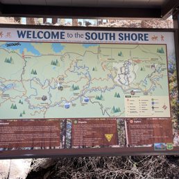
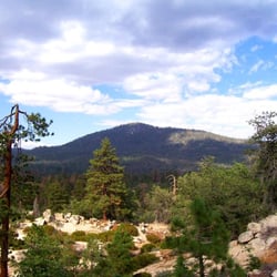
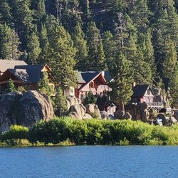
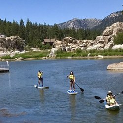
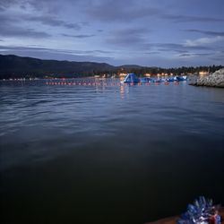
Castle Rock Trail Photos


You might also consider
More like Castle Rock Trail
Recommended Reviews - Castle Rock Trail
Start your review...

Reviews With Photos

After years of not being able to hike this trail (snow, ice, no parking, fires, etc.), I was finally able to do it! Huzzah for the new parking lot, which has quite a few parking spots, a bathroom, and easy access to the trailhead. Don't let the posted distance of the trailhead fool you - it's very easy to make this hike longer than anticipated. The trail markers are these caged rocks, and sometimes we lost track of them and had to guess. There are also a lot of places to scramble up rocks, which was so much fun. Once we found the sign for Castle Rock, my son (6 yo) and I took a look up, then climbed all the way to the top. The view from the top was amazing! Very much worth it. We took a different rock scrambling path to climb down, so there are options if you decide to climb up. With all of our meandering, scrambling, and just general shenanigans, we finished in about 3 hours feeling pretty accomplished.

This review is for Champion Lodgepole via Castle Rock Trail which was a ~4.8 miles round trip that took ~3 hours to complete. This was another stunning forest hike near Big Bear Lake, California. With the new parking lot, the beginning of the trail has changed. The first mile or so was a steep incline on dirt and some rocks. This part of the trail could be tricky to follow so try looking for the stack of rocks! After exiting Castle Rock Trail, it was mostly a flat dirt path that takes you to the Bluff Mesa Trail and then towards the Bluff Lake! On the way back down on Castle Rock Trail will reward you with some views of Big Bear Lake! There is now a new parking lot with at least 25 parking spaces available. No more street parking. Restroom available at the parking lot. Short video of the hike for those interested! https://youtu.be/4a_Q0hZUk7k

I like to think of myself as an avid hiker, like, actual hiking, not just throwing "outdoorsy" on my Tinder profile to reel in some hunnies. Castle Rock Trail is the real deal. Real dirt. Real trees. Real cardio. None of those fake hikes I'm used to back home in Las Vegas where you're basically just walking on a a road wondering if you should've brought a shopping cart. This trail makes you feel like you've earned it. Every step gets you closer to that I might have lungs of steel or I might need an inhaler moment. Just when you think, that's it, I'm turning back, five more minutes and boom: you're at the top with a view of the lake that makes all the huffing, puffing, and questionable life choices totally worth it. Pro tip: don't let the word "castle" fool you. There's no medieval banquet at the top, but there is a throne worthy view that'll make you feel like the King (or Queen) of Big Bear. Bring water, bring snacks, bring your sense of humor... and maybe bring proof for your dating profile that you didn't just walk around a park and call it a hike.

If you're making a trip to Big Bear and looking for a quick hike this is exactly what you're looking for! The trail head is right off the Big Bear Blvd. Look for the trail sign off the curve. Parking is either off the side of the road or there is very limited parking, less than 10 spots in a small turn off area. The trail itself is a beginner/intermediate level with a total length of about 0.5mi but has steep incline all the way up! The trail itself is pretty obvious since you just follow the steps, markings along the path. Total it will take about 15-30 minutes to get to the summit, depending how fast you walk and if you take breaks. The summit is a rock formation with beautiful panoramic view of Big Bear Lake. Overall a very easy walk for all age groups!


Wonderful trail! This made the drive worth to big bear because the trails have different scenery than LA. The beginning is a steep hike and it feels like you're running out of breath because it's at a high altitude. After 30 min or so it's not as steep and we saw lots of tall pine trees, rocks you can climb on, and of course the big bear lake view!

There are a number of things I wish I had known before doing this hike, so let me highlight those. 1. Castle Rock itself is located a little more than halfway up the trail. If you only want to see the view from there, you need not continue farther up. 2. It's easy to miss the right-hand path that takes you towards Castle Rock (or at least it was for me, lol). Although there is a small sign, I completely missed it while concentrating on staying on the most-traveled path. The best marker I can give is that it is at the point of a switchback where the most-traveled path makes a hard left. Also, if you turn around at some point and notice a rock formation that looks larger than all the others you've noticed, that's probably Castle Rock lol. 3. I could not find a discernable "top" or "best view" but I also was not willing to scramble up very far. Even without doing so, I did reach the point of finding some nice views anyway. 4. This hike is short, so we decided to continue to Bluff Lake Reserve. I highly recommend doing this, because it is so close and so worth it! At the end of this trail is a dirt road. If you follow it towards your right and take the first left, you're golden. We also saw a deer on the dirt road which was a nice surprise. Regarding parking, and as others have mentioned, it's limited. Since we knew that beforehand, we got there a lot earlier than we needed to, i.e., around 8 a.m. At that time there was only 1 other car parked before us. The largest turnout to park on is on the main road going west, just before the trailhead.
We enjoyed this moderate hike if one stay on the trail. We went off the trail slightly and had to climb through some boulders. The first 30 minutes of elevation gain was probably the strenuous section. The most difficult part was climbing up the Castle Rock with bare hands. Parking on the side of the road is limited, especially in the morning. Be very careful about car traffic. Overall, a great hike for the physical fit.

The hike every guide/blog recommends you to do in Big Bear! I really enjoyed this hike, I would say is definitely challenging with snow on the ground- trail markers are present but kind of camouflaged with everything. Even with a group of friends and the AllTrails route downloaded on our phones, we still went off trail a few times. But also, the main trail was covered in ice so it was better to go around in the snow at some points. Parking is also kind of confusing because there is virtually none- there's a small turnoff point after the Trail head on Big Bear Blvd, that's where we parked but it was not labeled as parking. Overall, great hike, beautiful views!

I have done this hike three times. The first two times it was just to Castle Rock and back and is only 2 miles RT. This last time I hiked it in March, we hiked a few miles past Castle Rock to Lookout Point. There were parts of the trail that still had snow (some parts were pretty deep) and there were parts of the trail that had no snow at all. The worst part was the first half a mile because it was the steepest and it was icy in parts. Parking- we always get there early(before 7 am) and don't have trouble finding parking; however there isn't a lot of parking and this place is pretty popular and gets busy later in the day Trail- it is a well-defined out and back trail and you don't have to worry about getting lost, however, if you go past Castle Rock like we did last time it was a bit hard to stay on trail especially because of the snow; if you do continue south past Castle Rock you will come upon Bluff Lake on your way to Lookout Point; now Lookout Point didn't have any sign or marker indicating the location but based on the AllTrails map I was using it was about 2 miles beyond Bluff Lake at an elevation of about 7,900 ft which is about 600 ft higher than Castle Rock...both places, Castle Rock and Lookout Point, reward you with great views


Good intermediate hike. We went with four little kids. So not terribly tough by any means. But it was steep. Nice thing about the trail, it didn't have too many switch backs. So overall hike was scenic and interesting. Good family hike. Though it did take us two hours to get there and back...... kids :-)

This trail is the best 2 1/2 mile hike in big bear. It does have a decent amount of elevation and the trail features climbing over tree stumps and rocks, but it is dog friendly and has a great climactic view of the lake. Tip for this trail is that there is a turn out and bend that you park in and come here before 9 AM to get a parking spot and to get the trail all to your self. Must do :) family friendly, dog friendly mix

4 months ago
4 months ago
We took this hike with our pups and it was awesome! It was definitely a work out with lots of steep and uphill hiking. We made it to the big rock at the very end, unfortunately with our pups we were unable to climb all the day to the tippy top. Overall an awesome hike, saw lots of trees, rocks, and little streams along the way! Trail is dog friendly, and has a lot of spots to stop for great views of the lake read more


11 days ago
Short hike, has many little side trails that all lead to the rock. It is steep. View is gorgeous. There's a smaller rock view that's super easy, but the very top is more like rock climbing but definitely worth it. read more

After years of not being able to hike this trail (snow, ice, no parking, fires, etc.), I was finally able to do it! Huzzah for the new parking lot, which has quite a few parking spots, a bathroom, and easy access to the trailhead. Don't let the posted distance of the trailhead fool you - it's very easy to make this hike longer than anticipated. The trail markers are these caged rocks, and sometimes we lost track of them and had to guess. There are also a lot of places to scramble up rocks, which was so much fun. Once we found the sign for Castle Rock, my son (6 yo) and I took a look up, then climbed all the way to the top. The view from the top was amazing! Very much worth it. We took a different rock scrambling path to climb down, so there are options if you decide to climb up. With all of our meandering, scrambling, and just general shenanigans, we finished in about 3 hours feeling pretty accomplished. read more

This review is for Champion Lodgepole via Castle Rock Trail which was a ~4.8 miles round trip that took ~3 hours to complete. This was another stunning forest hike near Big Bear Lake, California. With the new parking lot, the beginning of the trail has changed. The first mile or so was a steep incline on dirt and some rocks. This part of the trail could be tricky to follow so try looking for the stack of rocks! After exiting Castle Rock Trail, it was mostly a flat dirt path that takes you to the Bluff Mesa Trail and then towards the Bluff Lake! On the way back down on Castle Rock Trail will reward you with some views of Big Bear Lake! There is now a new parking lot with at least 25 parking spaces available. No more street parking. Restroom available at the parking lot. Short video of the hike for those interested! https://youtu.be/4a_Q0hZUk7k read more


I like to think of myself as an avid hiker, like, actual hiking, not just throwing "outdoorsy" on my Tinder profile to reel in some hunnies. Castle Rock Trail is the real deal. Real dirt. Real trees. Real cardio. None of those fake hikes I'm used to back home in Las Vegas where you're basically just walking on a a road wondering if you should've brought a shopping cart. This trail makes you feel like you've earned it. Every step gets you closer to that I might have lungs of steel or I might need an inhaler moment. Just when you think, that's it, I'm turning back, five more minutes and boom: you're at the top with a view of the lake that makes all the huffing, puffing, and questionable life choices totally worth it. Pro tip: don't let the word "castle" fool you. There's no medieval banquet at the top, but there is a throne worthy view that'll make you feel like the King (or Queen) of Big Bear. Bring water, bring snacks, bring your sense of humor... and maybe bring proof for your dating profile that you didn't just walk around a park and call it a hike. read more


If you're making a trip to Big Bear and looking for a quick hike this is exactly what you're looking for! The trail head is right off the Big Bear Blvd. Look for the trail sign off the curve. Parking is either off the side of the road or there is very limited parking, less than 10 spots in a small turn off area. The trail itself is a beginner/intermediate level with a total length of about 0.5mi but has steep incline all the way up! The trail itself is pretty obvious since you just follow the steps, markings along the path. Total it will take about 15-30 minutes to get to the summit, depending how fast you walk and if you take breaks. The summit is a rock formation with beautiful panoramic view of Big Bear Lake. Overall a very easy walk for all age groups! read more


Castle rock trail a very beautiful trail gorgeous to say the least from the vibrant trees and lake surrounding body of water as well . My first impression of big bear was amazing just the Christmas looking trees and forest not to mention the temperature was low seventies . read more


Wonderful trail! This made the drive worth to big bear because the trails have different scenery than LA. The beginning is a steep hike and it feels like you're running out of breath because it's at a high altitude. After 30 min or so it's not as steep and we saw lots of tall pine trees, rocks you can climb on, and of course the big bear lake view! read more


4 years ago
There are a number of things I wish I had known before doing this hike, so let me highlight those. 1. Castle Rock itself is located a little more than halfway up the trail. If you only want to see the view from there, you need not continue farther up. 2. It's easy to miss the right-hand path that takes you towards Castle Rock (or at least it was for me, lol). Although there is a small sign, I completely missed it while concentrating on staying on the most-traveled path. The best marker I can give is that it is at the point of a switchback where the most-traveled path makes a hard left. Also, if you turn around at some point and notice a rock formation that looks larger than all the others you've noticed, that's probably Castle Rock lol. 3. I could not find a discernable "top" or "best view" but I also was not willing to scramble up very far. Even without doing so, I did reach the point of finding some nice views anyway. 4. This hike is short, so we decided to continue to Bluff Lake Reserve. I highly recommend doing this, because it is so close and so worth it! At the end of this trail is a dirt road. If you follow it towards your right and take the first left, you're golden. We also saw a deer on the dirt road which was a nice surprise. Regarding parking, and as others have mentioned, it's limited. Since we knew that beforehand, we got there a lot earlier than we needed to, i.e., around 8 a.m. At that time there was only 1 other car parked before us. The largest turnout to park on is on the main road going west, just before the trailhead. read more

4 years ago
We enjoyed this moderate hike if one stay on the trail. We went off the trail slightly and had to climb through some boulders. The first 30 minutes of elevation gain was probably the strenuous section. The most difficult part was climbing up the Castle Rock with bare hands. Parking on the side of the road is limited, especially in the morning. Be very careful about car traffic. Overall, a great hike for the physical fit. read more


5 years ago
The hike every guide/blog recommends you to do in Big Bear! I really enjoyed this hike, I would say is definitely challenging with snow on the ground- trail markers are present but kind of camouflaged with everything. Even with a group of friends and the AllTrails route downloaded on our phones, we still went off trail a few times. But also, the main trail was covered in ice so it was better to go around in the snow at some points. Parking is also kind of confusing because there is virtually none- there's a small turnoff point after the Trail head on Big Bear Blvd, that's where we parked but it was not labeled as parking. Overall, great hike, beautiful views! read more

I have done this hike three times. The first two times it was just to Castle Rock and back and is only 2 miles RT. This last time I hiked it in March, we hiked a few miles past Castle Rock to Lookout Point. There were parts of the trail that still had snow (some parts were pretty deep) and there were parts of the trail that had no snow at all. The worst part was the first half a mile because it was the steepest and it was icy in parts. Parking- we always get there early(before 7 am) and don't have trouble finding parking; however there isn't a lot of parking and this place is pretty popular and gets busy later in the day Trail- it is a well-defined out and back trail and you don't have to worry about getting lost, however, if you go past Castle Rock like we did last time it was a bit hard to stay on trail especially because of the snow; if you do continue south past Castle Rock you will come upon Bluff Lake on your way to Lookout Point; now Lookout Point didn't have any sign or marker indicating the location but based on the AllTrails map I was using it was about 2 miles beyond Bluff Lake at an elevation of about 7,900 ft which is about 600 ft higher than Castle Rock...both places, Castle Rock and Lookout Point, reward you with great views read more


Good intermediate hike. We went with four little kids. So not terribly tough by any means. But it was steep. Nice thing about the trail, it didn't have too many switch backs. So overall hike was scenic and interesting. Good family hike. Though it did take us two hours to get there and back...... kids :-) read more


5 years ago
This trail is the best 2 1/2 mile hike in big bear. It does have a decent amount of elevation and the trail features climbing over tree stumps and rocks, but it is dog friendly and has a great climactic view of the lake. Tip for this trail is that there is a turn out and bend that you park in and come here before 9 AM to get a parking spot and to get the trail all to your self. Must do :) family friendly, dog friendly mix read more


3 years ago
It was a very short trail if you're coming from the main road and a decent amount of parking space. I hiked in mid May, so the weather was perfect for me. The trail was a little steep with an elevation of about 1,300 feet I think. The trail leading to castle rock had plenty of signs and trail markings and it was really helpful. There's a lot of flowing water (creeks) all around and with the birds chirping, it was really peaceful. But when you reach the top of castle rock, that's where the beauty nature at its best. The views are breathtaking and so worth the trip! read more


Great hike today! It is a moderate level hike. Make sure you take breaks and take water. Once you get deep into it, the nature and the trees are really majestic. There is also lots of shade too. The trail is definitely very rocky and slippery (due to sand) and steepness. My husband ate it down one of the steps. I would wear good shoes. The hike to the top is pretty much all rocks. Like literally boulder climbing. You'll need to figure out how to climb without slipping and go slow. But once you get to the top the views are awesome. We continued past castle rock and walked another mile to Lake Bluff. So pretty!! Wasn't as crowded and the grass fields are so beautiful. It's worth the extra mile. We came at 7am and got parking in the small lot across from the trailhead on hwy 18. There are porta potties. The lot was full within 10 minutes. Also the weather was cooler and it was less people at 7am. When we were returning at 10:30am, it was definitely a crowd. Also it's very dusty too. I got so much dust in my mouth. Go early! Socially distance! Have fun! :) read more

Great trail for the family and dogs! I would highly suggest going in the morning because the trail is not as covered as it could be. The trial is also a little hard to follow but there are piles of rocks with like chicken fencing around it. The actual castle rock is a little hard to find also when you go around a bend it's to the right and there's a sign on the tree that says 'Castle Rock' and you can explore that. We ended up going all the way up to the like camp ground area and came back before finding the castle rock. read more


We enjoyed hike there. Plenty of shade and lots of dogs there. I have two italian greyhounds and they can even handle the hike. Parking is tough. I recommend go early and parking along the street but limited. It's rocky and steep so wear shoes not sandals. I saw some ladies wore sandals and they even stoped at very beginning of trail. If you have kids or/and dogs, bring plenty of water. No bathroom there. We went to the end of castle rock trail and didn't go to the next lake though even the guy we met there told us 15 more minutes from the end of castle rock tail. Our babies were too tired and I couldn't take risk for them. Good news is you don't have to go too far from the beginning of trail. Once you climb up steep parts you see some rocks right and left of trail, you go up there and you will take plenty of beautiful pics to big bear lake. More towards the end of trail, you don't see much view but you see Castle Rock. Or you can go all the way to the next lake. There are chip munks and lizards my dogs were chasing. It was very fun hike for us. If my dogs are younger or we went there early enough before gets too hot, we would be gone to the next lake. read more


If you're starting this hike from the 18 (Big Bear Blvd) side, boy o boy... mentally prepare yourself for that initial climb! Although this hike is categorized as "moderate", the beginning is quite steep and rocky. You can definitely hear everyone huffing and puffing (myself included) and see people taking breaks here and there. Since we went on a weekend, it was extremely crowded. There was a single file "line" going up as well as another one going down. Just when you think you think you can't take anymore of the steep section, you'll be rewarded by a beautiful view of Big Bear lake once you turn around. This is a wonderful place to look for giant pinecones, relax on the rocks, and take pictures of course! After this section, the hike difficulty drops significantly and it's all smooth sailing from there. You have to get lucky with parking if entering from the 18 side. People park along the road, but it gets pretty packed on the weekends. read more


I am not a regular hiker, but staying in Big Bear makes you curious... So I did, and I loved it. Wat a beautiful trail! Each step is a photo shoot waiting to happen but it is too beautiful to grasp with your IPhone, so just walk and enjoy... It is quite a climb though, so come prepared and do not forget to bring water and some fruits for example! read more

We wanted a quick nearby hike to end our weekend and a friend recommended Castle Rock. Just up the street from our Airbnb on the lake, this trail gave us a great workout with the reward of scenic views at the top. Our little group loved it! Be warned: Parking is a nightmare. You're forced to find an open spot along Big Bear Blvd. around winding turns, and we had to loop back around at the dam at one point, but on our way back down, we lucked out and got a spot just past the trailhead. I don't know how folks park much farther than 20 or so feet from the entrance since you have to walk along the busy road with virtually no pedestrian space, so be careful! Also be warned: This is a steep hike. It's very, very short, but the entirety is steep uphill climbing. The trail itself is nicely laid out and maintained, with easily visible paths for walking up despite the natural elements that make it a tricky climb at first, but you get into a good groove, taking ample breaks to avoid letting the altitude get the best of ya. It's narrow, but there's always a spot to "pull over" and let others pass comfortably. I'm a fairly comfortable hiker, but I needed several breaks on our way up due to the thinness of the air. Aside from these factors, the hike is sublime! Gorgeous natural setting, plus lots of viewpoints once you get to the top after the mile-or-so trek up. Once you're at Castle Rock itself, the trail flattens out so that you can wander around the large rock formations to find other great views. We lucked out a lot on our just-before-sunset hike on an early December weekend (temps in the 40s, clear skies) but you can't go wrong with this one! I'd say that, if you're a nervous driver or uncomfortable with intense incline hikes, maybe pass on it, but my 50-something mom, who is both of these things, managed fairly well! Just take your time. read more


I was a little worried about the incline of this trail at first, but it is doable. We did this trail in April, so snow and ice was not an issue for us. Our group had people ranging from 9 to 65 years old. The trail has rock pillars to keep you on the path. The view from the top was amazing and worth the climb. read more


7 years ago
We survived this hike! Fyi, there is NO PARKING LOT. You have to park on the side of the road on Big Bear Blvd. As for the entrance, you will see a sign that says "Castle Rock Trail" and more than likely there will be people walking into this rocky trail. I would say this hike is a moderate level. Most areas are steep, easy to get lost, and it is kind of difficult hiking in the snow, as the ground and rocks are icy, making it easy to slip... which happened a lot with me & my friends. But this hike is good for all ages, especially dogs, but make sure you are prepared with good shoes/boots and bring lots of water. I wasn't able to make it to the very top, but I was close. From everyone's reviews, the hike is WORTH IT! Beautiful views and a wonderful opportunity to take amazing photographs. It is really difficult to hike when there's snow so bring the right equipment and watch your step! read more


Loved this trail. It was myself and my 13 y o dtr. 1st timers and managed our way up the rock and down. Not long at all. Took us about 1.5 hrs and that with stopping and taking pics. We also encounter other families with smaller kids and older adults too! Oh yea, there was a yellow rope that was left by someone to assist in climbing up the rock. That's how you know you've made it to Castle Rock! read more

8 years ago
6 years ago
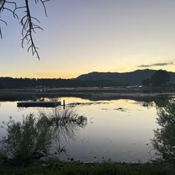
10-15 min hike to the top. Although, had to stop once to rest but was worth it ha. The view up there was just stunning ... Pics below read more


This is a straight uphill challenge. You will be going up a Rocky, dirt trail for 1.2 miles and then turn around and go down that same trail. It's beautiful along the way with the trees and lake view. There's rock markers enclosed in wire to keep you on the correct trail. At the top, there's a camp ground and road so if you can't make it down, someone can go get you on you can drive up for fun. We saw several nice dogs asking the way and children to seniors hiking it. It's narrow in a few parts, but not dangerous. Bring double the water (2 bottles or about 32-40 ounces per person at least for the entire hike). read more


All the reviews about the steep elevation at the beginning of the trail is absolutely correct! But also true are the many rock formations that allow for lots of hike breaks. The breathtaking view at the top is well worth the breathless climb that it takes to get there. It's not the easiest hike, but it's do-able for any recreational hiker. Even though parking is hit & miss, there were a couple turnouts along the highway 18 that allowed ample room for my SUV. Just be careful walking along the side of the highway and crossing it to get to the trail. The vehicles can speed pretty fast along the road. A seasoned hiker could hike this in an hour, but why rush the natural beauty all around. It took us (middle-aged couple + teen son) about 2.5 hours. Highly recommend this gem of a trail for all ages! read more


9 years ago
Parking is limited to the Main Street. The hike to Castle Rock is super fun. It is a short two mile round trip hike. You are able to add more miles to your hike by hiking around and to the various rock formations. The trail is good for all levels. It is very well marked as well. Currently no snow. A must do hike while visiting Big Bear. read more


7 years ago
The address listed here on yelp takes you to a small lookout spot where about 4-6 cars can fit. If these spots are taken you'll have to drive a bit for parking. The trail starts near that look out spot where the highway curves. You have to cross the highway to reach the trail (so be careful!) I hiked this trail a few days ago. It wasn't snowing but it was snowing 5 days earlier. Because of all the photos on here, I thought there wouldn't be snow on the trail (since many places in big bear didn't have snow). But to my surprise, the whole trail was covered with snow and ice. Therefore during the winter season I would not recommend this trail to kids, or people with bad knees. The trail is fairly easy but my friends and I were falling all over the place. Especially on the way down, the area near the bottom of the trail is extremely slippery. What makes it worse is there are no markings to tell you where to go. So every once in awhile we clearly went off path because there would be untouched snow. Other then that the hike was easy, beautiful, and so much fun. My friends and I spent a few hours playing in the snow and climbing on rocks and taking lots of photos. read more


7 years ago
really cool trail to hike in the Big Bear area. few things.... 1) not much parking, street parking if you can find any. 2) good for beginners 3) not very long, maybe 1-2 miles 4) not very steep, but a good about of climbing and descending 5) well marked trail 6) great views we had a great time hiking this trail, the kids were able to do it. its good for younger kids and adults alike. i would hike this trail again. read more


A relatively short hike up and back though the pine trees and rock formations. Because this is only a mile each way, it's perfect for those people that want to experience a trail without getting wiped out tired. The initial climb up can be a a bit strenuous if you're not acclimated to the altitude. You will be be rewarded a nice breeze when you push through the initial climb so look forward to it. Eventually you'll see the Castle Rock, you'll know it when you see it. Too bad there wasn't a better vantage point to capture more photos. I recommend Castle Rock trail when visiting Big Bear Lake.. - Lots of slippery gravel and sand, wear appropriate shoes. - Keep a keen eye for the arrow signs on trees. Without them you'll likely get lost. - Park on the street and walk to the trail. - Kid friendly if they wear the right shoes. read more


Page 1 of 7
More info about Castle Rock Trail
38523 Big Bear Blvd
Big Bear Lake, CA 92315
Directions
Visit Website
http://www.bigbearlake.net/summer/castle-rock-trail
Hours
Indoor Amenities
Outdoor Amenities
Ask the Community - Castle Rock Trail
Could you take a stroller?
I won't lie to you, might be difficult for that. Pretty bumpy ride up. Just a lot of debris, branches, rocks etc.
Im trying to find an easy hike that has an amazing view and a waterfall or no waterfall as long as it has an amazing view so it won't be to much on my friend?
It's a pretty intense beginning, 10-20 minutes of it then after that, there different paths you guys can take that are fairly easy. I would for sure say pack some water though. What I thought was going to be an hour maybe 2, turned into 4. Just such…
I read on Google Maps that this trail is temporarily closed. Is this true? Has anyone hiked it recently?
I also hiked in late August and it was open. That was on a Friday
Is it much inclined/ uphill , asking as my husband has knee pain and he wants to do?
It is a pretty steep trail. 580' of elevation gain in about 0.65 miles
This seems a pretty easy hike for first timers, as I assume it's a public post (not a guided tour), is it easy for new timers to get lost?
There is good signage and it gets pretty crowded after 11AM so I would worry about getting lost. It's a beautiful view and easy hike!
Review Highlights - Castle Rock Trail
You might also consider


Why does Yelp recommend reviews?
7 reviews that are not currently recommended
The reviews below are not factored into the business's overall star rating.
11 years ago
11 years ago
11 years ago
1 year ago
9 years ago
13 years ago
10 years ago
Castle Rock Trail - hiking - Updated July 2026
Best of Big Bear Lake
People found Castle Rock Trail by searching for…
Snow Play in Big Bear Lake, CA
Things to Do in Big Bear Lake, CA
Hiking Trails With Waterfalls in Big Bear Lake, CA
Campgrounds in Big Bear Lake, CA
Scenic Views in Big Bear Lake, CA
Swimming Holes in Big Bear Lake, CA
Star Gazing in Big Bear Lake, CA
Scenic Drive in Big Bear Lake, CA
Places to Take Pictures in Big Bear Lake, CA
Rock Climbing in Big Bear Lake, CA
Playgrounds in Big Bear Lake, CA
Natural Hot Springs in Big Bear Lake, CA
Things to Do at Night in Big Bear Lake, CA
Secret Spots in Big Bear Lake, CA
Sunset View in Big Bear Lake, CA
Free Parking in Big Bear Lake, CA
Stairs Workout in Big Bear Lake, CA
Dog Friendly Things to Do in Big Bear Lake, CA
Scenic Overlook in Big Bear Lake, CA
Dog Friendly Hiking Trails in Big Bear Lake, CA
Trending Searches in Big Bear Lake, CA
Blueberry Picking near Castle Rock Trail
Boat Tours near Castle Rock Trail
Cliff Jumping near Castle Rock Trail
Day Trips near Castle Rock Trail
Dog Friendly Beaches near Castle Rock Trail
Dog Friendly Trails near Castle Rock Trail
Free Picnic Areas near Castle Rock Trail
Jet Ski Rental near Castle Rock Trail
Kayak Rental near Castle Rock Trail
Off Road Trails near Castle Rock Trail
Outdoor Activities near Castle Rock Trail
Peach Picking near Castle Rock Trail
Places To Swim near Castle Rock Trail
Places To Walk Around near Castle Rock Trail
Public Shower near Castle Rock Trail
River Swimming near Castle Rock Trail
River Tubing near Castle Rock Trail
Rock Quarry near Castle Rock Trail
Scenic Night View near Castle Rock Trail
Scenic Overlook near Castle Rock Trail
Secluded Spots near Castle Rock Trail
Soccer Store near Castle Rock Trail
Sunrise View near Castle Rock Trail
Swimming Holes near Castle Rock Trail
Swimming Lakes near Castle Rock Trail
U Pick Farms near Castle Rock Trail
Browse Articles
Browse Nearby
BEST of Big Bear Lake, California Things to Do near Castle Rock Trail
BEST of Big Bear Lake, California Walking Trails near Castle Rock Trail
BEST of Big Bear Lake, California Coffee near Castle Rock Trail
BEST of Big Bear Lake, California Restaurants near Castle Rock Trail
BEST of Big Bear Lake, California Parks near Castle Rock Trail
BEST of Big Bear Lake, California Breakfast near Castle Rock Trail
BEST of Big Bear Lake, California Campgrounds near Castle Rock Trail
BEST of Big Bear Lake, California Sledding near Castle Rock Trail
BEST of Big Bear Lake, California Snow Tubing near Castle Rock Trail
Browse Brands
Related Searches in Big Bear Lake, CA
Best Dog Hiking Trails Around Big Bear Lake, California
Best Fishing Locations and Guides in Big Bear Lake, California
Best Gymnastics for Kids Activities in Big Bear Lake, California
Best Nature Trails for Hiking in Big Bear Lake, California
Best Places for Calisthenics Workouts in Big Bear Lake, California
Best Places for Horseback Riding in Big Bear Lake, California
Best Rock Climbing Gyms to Try in Big Bear Lake, California
Best Sledding Spots and Fun in Big Bear Lake, California
Best Spinning Classes Offered in Big Bear Lake, California
Challenge Yourself With an Obstacle Course in Big Bear Lake, California
Check Out Off Road Trails in Big Bear Lake, California
Discover Dog Friendly Trails to Explore in Big Bear Lake, California
Discover Easy Hiking Trails Near Big Bear Lake, California
Discover Fun Recreation Activities in Big Bear Lake, California
Discover Great Fitness Classes Available in Big Bear Lake, California
Discover Kid Friendly Hiking Trails in Big Bear Lake, California
Discover Kids Yoga Classes Near Big Bear Lake, California
Discover Popular Bike Trails in Big Bear Lake, California
Discover Popular Ropes Course Options in Big Bear Lake, California
Discover Rock Climbing Walls in Big Bear Lake, California
Discover Top Yoga Options and Studios in Big Bear Lake, California
Discover Walking Parks in Big Bear Lake, California Near You
Discover a Hiking Trail in Big Bear Lake, California
Discover the Best Night Hike Trails in Big Bear Lake, California
Discover the Best Parkour Gyms in Big Bear Lake, California
Dog-Friendly Hikes With Dogs in Big Bear Lake, California
Enjoy Camping Adventures Around Big Bear Lake, California
Enjoy Hiking Adventures in Big Bear Lake, California
Enjoy Kayaking Adventures in Big Bear Lake, California
Enjoy Off Leash Dog Hikes in Big Bear Lake, California
Enjoy Safe and Fun Bungee Jumping in Big Bear Lake, California
Enjoy Scenic Places to Walk in Big Bear Lake, California
Enjoy Tent Camping Spots Around Big Bear Lake, California
Enjoy a Beautiful Waterfall Hike in Big Bear Lake, California
Enjoy the Best Bouldering Experiences in Big Bear Lake, California
Enjoy the Best Picnic Spots and Ideas in Big Bear Lake, California
Enjoy the Best Walking Path in Big Bear Lake, California
Enjoy the Best Walking Trails in Big Bear Lake, California
Experience Aerial Yoga Sessions in Big Bear Lake, California
Explore Beautiful Parks and Green Spaces in Big Bear Lake, California
Explore Boxing Classes for Fitness and Skill in Big Bear Lake, California
Explore Easy Hikes Perfect for All in Big Bear Lake, California
Explore Fun Activities to Do in Big Bear Lake, California
Explore Fun Challenge Courses in Big Bear Lake, California
Explore Martial Arts Options in Big Bear Lake, California
Explore Popular Campgrounds Near Big Bear Lake, California
Explore Top Dog Parks in Big Bear Lake, California Near You
Explore Top Parkour Spots and Activities in Big Bear Lake, California
People who viewed Castle Rock Trail also viewed
Pine Knot Trail
69 reviews
Gray's Peak Trail
20 reviews
Cougar Crest Trail
79 reviews
Woodland Interpretive Trail
58 reviews
Big Bear Lake Woodland Trail
5 reviews
Rathbun Creek Trail
12 reviews
Will Abell Memorial Trail at Arrowhead Ridge
18 reviews
Bristlecone Trail
4 reviews
Town Trail
4 reviews
Arrowhead Pinnacles Trail
4 reviews