San Jacinto Wildlife Area Photos


You might also consider
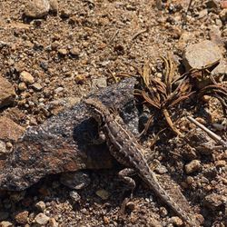
More like San Jacinto Wildlife Area
Recommended Reviews - San Jacinto Wildlife Area
Start your review...

5 years ago
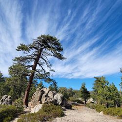
I finally decided to check this place out for the first time, this afternoon. I entered from Ramona Expy and made a left on Davis Rd. You will drive down a paved road and the rest will be a pebble, dirt road! Man, does my car need a car wash after today! I made a right at W Contour Rd. At this parking lot, they have 1 restroom in a building and a picnic table. I had to use the restroom as I was drinking Starbucks on the way over!! The restroom was clean with paper!!! I continued driving on the "auto tour" and I followed the signs. I saw a beautiful lake with no water. (I thought this was a beautiful view). I kept driving until I saw Pond 1 and I parked in the huge gray pebbled parking lot. I walked along the upper path between both ponds on both sides of me. I took many pictures & videos. I walked until I saw Marsh U and that is where I saw a skunk !!! I have never encountered one during the day. The skunk saw me and ran in the other direction. I wish I brought bug repellent. I was covered in bugs I knew something bit me on my arm. The place felt very eerie walking through there with no one around. I suppose the best times to visit are spring & winter! Enjoy my photos :) read more


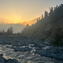
Visited here twice in the past week. It's nicely maintained and a great escape from the noise of the city. Keep in mind this isn't a well groomed and cliche/touristy picnic spot for you city slickers. I love how they have kept the area natural but still accessible. Wednesdays and Saturdays are closed to the general public for the waterfowl/duck hunters. This area is run and managed by the California Fish and Wildlife. If you're interested in wildlife (raptors and other birds in particular), this place is great. It's also quite scenic at sunrise and sunset as well. read more


3 years ago
6 years ago
10 years ago
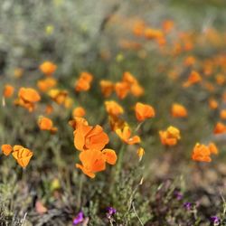
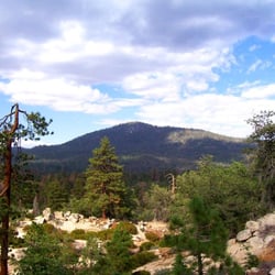
This is an enchanting wildlife area, the best kept secret, right next to Moreno Valley and just north of Nuevo, CA. If you ever get the chance to go, take it! There's restored wetlands, marshes, and the old San Jacinto River. You won't be disappointed; tell a friend... read more


More info about San Jacinto Wildlife Area
You might also consider


San Jacinto Wildlife Area - hiking - Updated July 2026
Best of Nuevo
People found San Jacinto Wildlife Area by searching for…
Fishing Spots in Nuevo, California
Things to Do in Nuevo, California
Scenic Drive in Nuevo, California
Photo Spots in Nuevo, California
Places to Take Pictures in Nuevo, California
Scenic View in Nuevo, California
Secret Spots in Nuevo, California
River Swimming in Nuevo, California
Attractions in Nuevo, California
Hiking Trails With Waterfalls in Nuevo, California
Beautiful Views in Nuevo, California
Fishing Lake in Nuevo, California
Watch Sunset in Nuevo, California
Swimming Lakes in Nuevo, California
Duck Pond in Nuevo, California
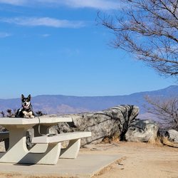
Picnic Areas in Nuevo, California
Scenic Spots in Nuevo, California
Lakes & Ponds in Nuevo, California
Fun Things to Do at Night in Nuevo, California
Walking Trails in Nuevo, California
Trending Searches in Nuevo, CA
4th Of July Fireworks near San Jacinto Wildlife Area
Baseball Fields near San Jacinto Wildlife Area
Black Owned Nail Salons near San Jacinto Wildlife Area
Boardwalk near San Jacinto Wildlife Area
Boat Rental near San Jacinto Wildlife Area
Cliff Jumping near San Jacinto Wildlife Area
Day Trips near San Jacinto Wildlife Area
Dog Friendly Beaches near San Jacinto Wildlife Area
Fireworks near San Jacinto Wildlife Area
Fishing Spots near San Jacinto Wildlife Area
Jet Ski Rental near San Jacinto Wildlife Area
Kayak Rental near San Jacinto Wildlife Area
Lakes near San Jacinto Wildlife Area
Lakes & Ponds near San Jacinto Wildlife Area
Off Road Trails near San Jacinto Wildlife Area
Outdoor Activities near San Jacinto Wildlife Area
Outdoor Basketball Courts near San Jacinto Wildlife Area
Paddle Boat Rentals near San Jacinto Wildlife Area
Parks For Picnics near San Jacinto Wildlife Area
Places To Walk Around near San Jacinto Wildlife Area
Public Pools near San Jacinto Wildlife Area
Public Shower near San Jacinto Wildlife Area
River Swimming near San Jacinto Wildlife Area
Rock Quarry near San Jacinto Wildlife Area
Scenic Night View near San Jacinto Wildlife Area
Scenic Overlook near San Jacinto Wildlife Area
Secluded Spots near San Jacinto Wildlife Area
Soccer Store near San Jacinto Wildlife Area
Splash Pad near San Jacinto Wildlife Area
Strawberry Picking near San Jacinto Wildlife Area
Sunrise View near San Jacinto Wildlife Area
Swimming Holes near San Jacinto Wildlife Area
Swimming Lakes near San Jacinto Wildlife Area
Watch Sunset near San Jacinto Wildlife Area
Browse Nearby
Browse Brands
Related Searches in Nuevo, CA
Best Fishing Locations and Guides in Nuevo, California
Best Nature Trails for Hiking in Nuevo, California
Best Off Leash Dog Parks in Nuevo, California
Best Parks for Parties and Events in Nuevo, California
Best Places for Horseback Riding in Nuevo, California
Best Sledding Spots and Fun in Nuevo, California
Best Water Parks for Kids in Nuevo, California
Best Waterfalls and Swimming Holes in Nuevo, California
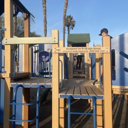
Check Out Great Playgrounds in Nuevo, California
Check Out Off Road Trails in Nuevo, California
Discover Baseball Fields Around Nuevo, California
Discover Beautiful Garden Spots in Nuevo, California
Discover Dog Friendly Trails to Explore in Nuevo, California
Discover Fun Toddler Parks in Nuevo, California for Your Little One
Discover Kid Friendly Hiking Trails in Nuevo, California
Discover Lakes & Ponds to Explore in Nuevo, California
Discover Popular Photo Spots in Nuevo, California
Discover Soccer Fields in Nuevo, California Near You
Discover Top Nature Parks to Visit in Nuevo, California
Discover Top State Parks to Visit in Nuevo, California
Discover Walking Parks in Nuevo, California Near You
Discover a Hiking Trail in Nuevo, California
Discover the Best Beaches in Nuevo, California
Discover the Best Kids Park Spots in Nuevo, California
Discover the Best Night Hike Trails in Nuevo, California
Discover the Best Running Track in Nuevo, California
Dog-Friendly Hikes With Dogs in Nuevo, California
Effective Stairs Workout Spots in Nuevo, California
Enjoy Camping Adventures Around Nuevo, California
Enjoy Exciting Mountain Biking Adventures in Nuevo, California
Enjoy Kayaking Adventures in Nuevo, California
Enjoy Tent Camping Spots Around Nuevo, California
Enjoy a Beautiful Waterfall Hike in Nuevo, California
Enjoy the Best Picnic Spots and Ideas in Nuevo, California
Enjoy the Best Walking Trails in Nuevo, California
Exciting Cliff Jumping Spots in Nuevo, California
Explore Beautiful Botanical Gardens in Nuevo, California
Explore Beautiful Parks and Green Spaces in Nuevo, California
Explore Easy Hikes Perfect for All in Nuevo, California
Explore Family-Friendly Zoos and Wildlife in Nuevo, California
Explore Free Picnic Areas Around Nuevo, California
Explore Fun Activities to Do in Nuevo, California
Explore Parks With Pull Up Bars in Nuevo, California
Explore Pickleball Courts in Nuevo, California
Explore Popular Campgrounds Near Nuevo, California
Explore Popular Picnic Areas Around Nuevo, California
Explore Popular RV Parks Around Nuevo, California
Explore Popular Recreation Centers Around Nuevo, California
Browse Articles
People who viewed San Jacinto Wildlife Area also viewed
Box Springs Mountain Reserve
60 reviews
Black Mountain Trail
5 reviews
The Oaks at Soboba Park
3 reviews
Windsong Family Park
1 review
Big Falls
78 reviews
San Gorgonio South Fork Trail
3 reviews
Diamond Valley Lake Marina
66 reviews
Hofmann Park & Community Center
1 review
Lake Fulmor
43 reviews
Main Divide Trail to Los Pinos Peak
2 reviews