
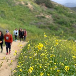
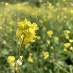
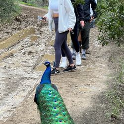
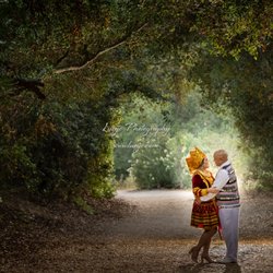
Santa Ana River Trail Photos


You might also consider
More like Santa Ana River Trail
Recommended Reviews - Santa Ana River Trail
Start your review...

Reviews With Photos - Santa Ana River Trail

The path is gorgeous! We did a full 5k run and could have gone longer, except there were no restrooms on site (at least none that we saw). The path is very clean, no homeless or littering at all. We went before the sun hit is peak as there is not many shades besides your occasional bridge and few trees. The water looks pretty and is a very peaceful site. I felt very safe. There were plenty of bikers and only a few other runners.


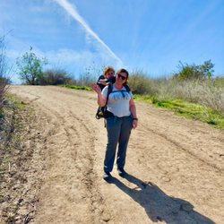
My husband and I visit this river bed almost every day. We live nearby, so it's a short walk. He runs, and I walk. It's perfect, especially for social distancing and getting your steps in. My goal is at least 10,000 steps, which takes about an hour and a half to two hours to complete. Most of the time, it's less because in the morning, I usually walk about 5,000 steps around my apartment complex. We often go in the late afternoon, and there aren't that many people. If you don't want to run or walk, there is a bike trail. I see many people come and go on their bicycles.
I saw tons of review ages ago concerning about the homeless being there. They don't have this problem no more. I've been riding this trail for the past half a year and i don't see a problem. The trail is smooth and clean with the option of dirt trail and road trail. Perfect for people running, walking, jogging and cycling. The trail goes from Newport Beach to Yorba Linda. They have the best sunset there, just look at my photos. Lots of vegetation and animals. People, please maintain this place clean. :) Thanks!

Down by the trail Where the bikers go Back on the trail I dare not go For if I do My mother would say Did you ever see A bike, losing its breaks Down by the trail Yea, Im the one on the 17.5 inch 29er on the river trail, ask me if I care. Cuz I dont. Yes, this is a road trail. But Ive put to much into my 29er, and Im going to ride it here, if Im riding street, which is usually unlikely. I like the dirt. This trail is what you make of it. There are lots of places to enter the trail. I used to enter it near Angel Stadium, park my car and take off down to the beach and back. But I dont think that particular lot allows parking. The trail is all road, and primarily flat with a few easy roller coaster type bumps. The roadies, are quick and usually shout out as they pass you. There is also Edison Park, which is a great place to park, have a BBQ then ride. 2 stars...1 star bonus for the beach.

Another weekend, another trail to explore. This one is super easy and is really more for biking. The views are pretty blah and more city scape than nature. It's not a loop, but an up and back trail for 8 miles. It does connect to various other trails and will get you all the way to the beach if you keep going. I'd probably not go for a walk on it again, but would give a try on my bike

Nothing like a long stretch of concrete with steep hills to work you out and level up . Definitely go with a water backpack . I started on the lower side by fountain valley . It is maintained by the city while there I saw multiple city trucks . All graffiti is painted over . Mostly bicyclist but a couple marathon runners (pacers ) I'd recommend if you're the type that likes to workout alone and be In Your zone

Everyone is gone and it's all cleaned up. They re-route you through a few service roads that are right next to the trail where it was most contaminated from Taft to Orangewood. Parts of the trail area are fenced off because they said they need to remove the contaminated dirt but it doesn't look like anything is happening yet. It's really hard to believe how clean it is. On a recent Sunday we saw dozens of riders, walkers and families enjoying the trail - people that were understandably not venturing through here a couple of months back. I've seen more homeless now on the trail to the east of here but they're not setting up permanent camps. Let the good time roll.
I am not a hardcore cyclist by no manner of means! I do not own a road bike nor do I bike on a regular basis. I came to the Santa Ana River Trail after searching for paved biking trails in Orange County on Yelp. I thought it was really impressive that one could run/bike/walk from Anaheim to Huntington Beach via this trail... I just never thought of the existence of such a "highway" system for pedestrians/cyclists in the OC. Furthermore, the trail continues farther north of Anaheim for miles and miles, but I have yet to explore it. According to their website, it will be possible to reach Big Bear Lake when complete: "Welcome to the Santa Ana River region's longest recreational trail and parkway. When complete this 110-mile trail and bikeway corridor will reach from Big Bear Lake, high in the San Bernardino Mountains, to the mouth of the Santa Ana River, at the Pacific Ocean." I parked in the lot where there is a Starbucks near the Honda Center and easily found an access point to the trail. I traveled southbound from Anaheim to Santa Ana and turned back because the sun was setting. It was pretty scary (but kind of thrilling?) once it started getting dark because the trail is not brightly lit, and I was by myself.... I will definitely not do that again!! I never pedaled faster in my life!!! :P I look forward to checking this trail out again and biking to Huntington Beach ;)

From the Pacific Ocean, in Huntington Beach, to Montrose Beach & the base of the mountains, in San Bernardino, the Santa Ana River travels 70 miles or so. Most of the River is accessable by Bicycle, including all of it in Orange County. In 2007, for my Blog The Cycling Dude, I rode the whole length, and took plenty of photos. This ride is a joy to take, from top to bottom, in either direction, and you will learn a lot about the communities it passes through, and about the environment. The Santa Ana River Bike Trail begins on the north side of the river, at the border of Huntington Beach and Newport Beach and there are 2 entrances: 1 on the East side of Pacific Coast Highway, 1 on the beach side. At 4 1/2 mi. you get your first glimpse of how Mother Natures march to the Sea has been briefly interupted by the hand of man. How Nature, and the hand of Man, battle for control of who shapes the landscape is a recurring theme of your journey, with Man seemingly having the upper hand in the OC. At several spots along the route the Bike Trail switches from one side of the river to the other. The ride is mostly flat and depending on the time of day, and day of the week, you will share the trail with families out for the day, walkers, joggers, and other bicyclists, from fellow individuals, and Club Rides, large, and small. There are plenty of opportunities to leave the trail for food, and bathroom breaks. While there is the occasional graffiti, trouble from gang bangers is not an issue. There ARE few spots in Santa Ana, and Anaheim, where you might encounter small Homeless Encampments under a bridge, and you might encounter a lone Homeless man resting along the trail anywhere along your journey, from time to time, but they tend to keep to themselves. Flowing water, flowery weeds and bushes often appear in the river, and many spots are prime hangouts for birds of all persuasions. At 22 1/2 mi. the river is really flowing, the freeway is on your right and Yorba Regional Park is on your left and, if you choose to continue further inland, into Riverside County, this is your first inkling that Mother Nature only relented completely to the hand of man, in her march to the ocean, only after the river had traveled a few short miles into the OC. At 26 3/4 mi. you come to La Palma Ave. & Gypsum Canyon Rd. Cyclists interested in continuing into Riverside County take note of a little brown sign on the wall nearby. Turn right, here, because to go under the bridge and continue on the trail will lead somewhere else. Turn right, ride to the corner, and turn right again. Following the green signs, to the right, the trail enters Canyon RV Park, then heads into a narrow passage where the freeway is on my right, and the east end of Featherly Regional Park, on my left. The last leg heads past the Coal Canyon entrance to Chino Hills State Park, and Green River Golf Club. Take a good look around because this is the last sight of the flowing river that you will see for almost 15 miles. The trail official ends at 29 mi., at the entrance to Green River Golf Club on Green River Rd., and to reach the start of the Bike Trail in Riverside County means a 15 mile ride thru the streets of Corona, and Norco. To see read my Detailed Report, with Pictures, and to read the Riverside County/San Bernardino County Report with its pictures, as well... go here: http://www.cyclingdude.com/2007/12/rolling-rolling.html

This trail is much cleaner as many recall, once as seen on the highway near the Angel Stadium there were entire campsites of homeless often blocking the trail; it had been a problem for decades until 2018. I hope many of them found a proper shelter or at least some semblance of help. The trail has a familiar design and path and is simple to navigate yet daring when doing so in reverse as the winds will getcha.

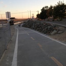
There are definitely negatives to this trail, including the freeway traffic noise, sewage smell at certain points of the trail, and as many reviewers stated, the prolific homeless population clustered near the 22 freeway (by Angel Stadium). However, there aren't many lengthy, paved bike trails in the San Bernardino/OC area, so I'm grateful this 30 mile stretch exists where I can bike without worrying about getting hit by a car. It's a bonus that it ends at the beach! If you're looking for a bike trail that is nice and leisurely, this one is more than satisfactory.

This place has taken up so much of my time I cant hardly believe it. Light or Dark, day or night, weekday or weekend, what a great place to have available. I have ridden hundreds of miles on my bike and skated a lot of miles on rollerblades as well. It is something that gets repaved every few years which it always eneds with new tree roots growing under the path. This is the kind of place that gets a lot of great use by the general public and ive never come across anything bad here. There are a lot of cyclists like myself, rollerbladers, horse riders, walkers, runners/joggers, nature lovers, bird watchers, kids playing around, dog walkers, etc. It is just one of the best places to get out of the house and enjoy the scenery. Check it out unless you are an anti exercising couch blob. Its a great thing though. If you want to go and have some fun times alone or with friends just go... what more could you ever want... It goes from the edge of the IE in Corona all the way down to the beach near Huntington/Newport passing places like the Big A and The Pond in Anaheim on the way. There are lots of portapotties, fountains, rest stops/picnic areas, bird watching locations, etc. What a fun fun place to go and get out. :) See you there soon!

1 month ago
I've been biking on this trail everyday now. Personally, I'm getting more and more fond of it. It's trying to be part of my lifestyle these days. The trail is relatively safe. I don't see as many homeless people as I used to which is a very nice and refreshing. Some of the landscapes along the trail are just too beautiful. Who needs a gym when you have the Santa Ana River Trail! read more

3 years ago
This trail has so many great parks and a little bathroom Along the route. Very safe and clear. Be careful of bikers but there are trails for runners. Go earlier if you're a runner. The bikers come after 7am. Highly recommend if you're in the area. Fun for all ages read more


I have had this place bookmarked forever and finally experienced the Santa Ana River Trail. I live in the neighboring apartments by the Angel Stadium so I have no idea why it has taken me almost two years to finally experience this gem! Entrance: Multiple entrances but the one most convenient to my apartment is right by Angel stadium parking lot across from golden road which is DuPont and Orangewood. If you don't live in the nearby apartments then I recommend parking by golden road brewery and walking over. You will see bike pathways with entrances (attached photo). Otherwise, the bike trail has quite a few bikers so don't be that annoying pedestrian that is in the way. Walk along the side, lol. If you enter by Angel Stadium the trail to the left will take you down to Honda center, roughly 1.2 miles, maybe a little less. Otherwise, the trail circles back and takes you down to Orange, and then some. I stopped around 4 miles since it started to drizzle but would love to see how long this trail can go! Tip--they cleaned up this trail tremendously. I saw no homeless people or anybody loitering. I felt safe going by myself on a Sunday morning. read more


The path is gorgeous! We did a full 5k run and could have gone longer, except there were no restrooms on site (at least none that we saw). The path is very clean, no homeless or littering at all. We went before the sun hit is peak as there is not many shades besides your occasional bridge and few trees. The water looks pretty and is a very peaceful site. I felt very safe. There were plenty of bikers and only a few other runners. read more

3 years ago
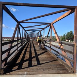
Beautiful place to ride e-bikes, run or walk. The bridge is so cool. We even saw a Bald Eagle. The picture didn't turn out the best because it was far away. My husband and I enjoyed our ride very much, and I am sure we will be going there more often. read more


6 years ago
My husband and I visit this river bed almost every day. We live nearby, so it's a short walk. He runs, and I walk. It's perfect, especially for social distancing and getting your steps in. My goal is at least 10,000 steps, which takes about an hour and a half to two hours to complete. Most of the time, it's less because in the morning, I usually walk about 5,000 steps around my apartment complex. We often go in the late afternoon, and there aren't that many people. If you don't want to run or walk, there is a bike trail. I see many people come and go on their bicycles. read more


7 years ago
I saw tons of review ages ago concerning about the homeless being there. They don't have this problem no more. I've been riding this trail for the past half a year and i don't see a problem. The trail is smooth and clean with the option of dirt trail and road trail. Perfect for people running, walking, jogging and cycling. The trail goes from Newport Beach to Yorba Linda. They have the best sunset there, just look at my photos. Lots of vegetation and animals. People, please maintain this place clean. :) Thanks! read more


Down by the trail Where the bikers go Back on the trail I dare not go For if I do My mother would say Did you ever see A bike, losing its breaks Down by the trail Yea, Im the one on the 17.5 inch 29er on the river trail, ask me if I care. Cuz I dont. Yes, this is a road trail. But Ive put to much into my 29er, and Im going to ride it here, if Im riding street, which is usually unlikely. I like the dirt. This trail is what you make of it. There are lots of places to enter the trail. I used to enter it near Angel Stadium, park my car and take off down to the beach and back. But I dont think that particular lot allows parking. The trail is all road, and primarily flat with a few easy roller coaster type bumps. The roadies, are quick and usually shout out as they pass you. There is also Edison Park, which is a great place to park, have a BBQ then ride. 2 stars...1 star bonus for the beach. read more


Another weekend, another trail to explore. This one is super easy and is really more for biking. The views are pretty blah and more city scape than nature. It's not a loop, but an up and back trail for 8 miles. It does connect to various other trails and will get you all the way to the beach if you keep going. I'd probably not go for a walk on it again, but would give a try on my bike read more


Nothing like a long stretch of concrete with steep hills to work you out and level up . Definitely go with a water backpack . I started on the lower side by fountain valley . It is maintained by the city while there I saw multiple city trucks . All graffiti is painted over . Mostly bicyclist but a couple marathon runners (pacers ) I'd recommend if you're the type that likes to workout alone and be In Your zone read more


16 years ago
8 years ago
Everyone is gone and it's all cleaned up. They re-route you through a few service roads that are right next to the trail where it was most contaminated from Taft to Orangewood. Parts of the trail area are fenced off because they said they need to remove the contaminated dirt but it doesn't look like anything is happening yet. It's really hard to believe how clean it is. On a recent Sunday we saw dozens of riders, walkers and families enjoying the trail - people that were understandably not venturing through here a couple of months back. I've seen more homeless now on the trail to the east of here but they're not setting up permanent camps. Let the good time roll. read more


6 years ago
5 years ago
13 years ago
I am not a hardcore cyclist by no manner of means! I do not own a road bike nor do I bike on a regular basis. I came to the Santa Ana River Trail after searching for paved biking trails in Orange County on Yelp. I thought it was really impressive that one could run/bike/walk from Anaheim to Huntington Beach via this trail... I just never thought of the existence of such a "highway" system for pedestrians/cyclists in the OC. Furthermore, the trail continues farther north of Anaheim for miles and miles, but I have yet to explore it. According to their website, it will be possible to reach Big Bear Lake when complete: "Welcome to the Santa Ana River region's longest recreational trail and parkway. When complete this 110-mile trail and bikeway corridor will reach from Big Bear Lake, high in the San Bernardino Mountains, to the mouth of the Santa Ana River, at the Pacific Ocean." I parked in the lot where there is a Starbucks near the Honda Center and easily found an access point to the trail. I traveled southbound from Anaheim to Santa Ana and turned back because the sun was setting. It was pretty scary (but kind of thrilling?) once it started getting dark because the trail is not brightly lit, and I was by myself.... I will definitely not do that again!! I never pedaled faster in my life!!! :P I look forward to checking this trail out again and biking to Huntington Beach ;) read more


From the Pacific Ocean, in Huntington Beach, to Montrose Beach & the base of the mountains, in San Bernardino, the Santa Ana River travels 70 miles or so. Most of the River is accessable by Bicycle, including all of it in Orange County. In 2007, for my Blog The Cycling Dude, I rode the whole length, and took plenty of photos. This ride is a joy to take, from top to bottom, in either direction, and you will learn a lot about the communities it passes through, and about the environment. The Santa Ana River Bike Trail begins on the north side of the river, at the border of Huntington Beach and Newport Beach and there are 2 entrances: 1 on the East side of Pacific Coast Highway, 1 on the beach side. At 4 1/2 mi. you get your first glimpse of how Mother Natures march to the Sea has been briefly interupted by the hand of man. How Nature, and the hand of Man, battle for control of who shapes the landscape is a recurring theme of your journey, with Man seemingly having the upper hand in the OC. At several spots along the route the Bike Trail switches from one side of the river to the other. The ride is mostly flat and depending on the time of day, and day of the week, you will share the trail with families out for the day, walkers, joggers, and other bicyclists, from fellow individuals, and Club Rides, large, and small. There are plenty of opportunities to leave the trail for food, and bathroom breaks. While there is the occasional graffiti, trouble from gang bangers is not an issue. There ARE few spots in Santa Ana, and Anaheim, where you might encounter small Homeless Encampments under a bridge, and you might encounter a lone Homeless man resting along the trail anywhere along your journey, from time to time, but they tend to keep to themselves. Flowing water, flowery weeds and bushes often appear in the river, and many spots are prime hangouts for birds of all persuasions. At 22 1/2 mi. the river is really flowing, the freeway is on your right and Yorba Regional Park is on your left and, if you choose to continue further inland, into Riverside County, this is your first inkling that Mother Nature only relented completely to the hand of man, in her march to the ocean, only after the river had traveled a few short miles into the OC. At 26 3/4 mi. you come to La Palma Ave. & Gypsum Canyon Rd. Cyclists interested in continuing into Riverside County take note of a little brown sign on the wall nearby. Turn right, here, because to go under the bridge and continue on the trail will lead somewhere else. Turn right, ride to the corner, and turn right again. Following the green signs, to the right, the trail enters Canyon RV Park, then heads into a narrow passage where the freeway is on my right, and the east end of Featherly Regional Park, on my left. The last leg heads past the Coal Canyon entrance to Chino Hills State Park, and Green River Golf Club. Take a good look around because this is the last sight of the flowing river that you will see for almost 15 miles. The trail official ends at 29 mi., at the entrance to Green River Golf Club on Green River Rd., and to reach the start of the Bike Trail in Riverside County means a 15 mile ride thru the streets of Corona, and Norco. To see read my Detailed Report, with Pictures, and to read the Riverside County/San Bernardino County Report with its pictures, as well... go here: http://www.cyclingdude.com/2007/12/rolling-rolling.html read more


7 years ago
This trail is much cleaner as many recall, once as seen on the highway near the Angel Stadium there were entire campsites of homeless often blocking the trail; it had been a problem for decades until 2018. I hope many of them found a proper shelter or at least some semblance of help. The trail has a familiar design and path and is simple to navigate yet daring when doing so in reverse as the winds will getcha. read more


9 years ago
There are definitely negatives to this trail, including the freeway traffic noise, sewage smell at certain points of the trail, and as many reviewers stated, the prolific homeless population clustered near the 22 freeway (by Angel Stadium). However, there aren't many lengthy, paved bike trails in the San Bernardino/OC area, so I'm grateful this 30 mile stretch exists where I can bike without worrying about getting hit by a car. It's a bonus that it ends at the beach! If you're looking for a bike trail that is nice and leisurely, this one is more than satisfactory. read more


This place has taken up so much of my time I cant hardly believe it. Light or Dark, day or night, weekday or weekend, what a great place to have available. I have ridden hundreds of miles on my bike and skated a lot of miles on rollerblades as well. It is something that gets repaved every few years which it always eneds with new tree roots growing under the path. This is the kind of place that gets a lot of great use by the general public and ive never come across anything bad here. There are a lot of cyclists like myself, rollerbladers, horse riders, walkers, runners/joggers, nature lovers, bird watchers, kids playing around, dog walkers, etc. It is just one of the best places to get out of the house and enjoy the scenery. Check it out unless you are an anti exercising couch blob. Its a great thing though. If you want to go and have some fun times alone or with friends just go... what more could you ever want... It goes from the edge of the IE in Corona all the way down to the beach near Huntington/Newport passing places like the Big A and The Pond in Anaheim on the way. There are lots of portapotties, fountains, rest stops/picnic areas, bird watching locations, etc. What a fun fun place to go and get out. :) See you there soon! read more


17 years ago
I had a great time riding the Santa Ana River Trail. During my most recent bicycling excursion, I entered at Batavia and Lincoln and took the trail all the way to Brookhurst & PCH in Huntington Beach. What a great workout and since the weather was nice, I got a great tan too. This was not my first time riding the trail and will certainly not be my last. The only thing I would guard against is that occasionally, you can run into some unsavory folks but, if you bring a buddy and ride during the day, you should have no trouble. read more


15 years ago
i love this trail! i've lived in Santa Ana for the past 5 years and only a few months ago have i started to ride my bike on it. I have to say its perfect for the cyclist! its paved, wide enough to pass up the runners, and the scenery is great that you'll end up miles down the rode and wont even know it! its a public place so obviously there are a few bums who stay under the bridge away from the path. They aren't there to hurt you, they are just living there life as best as possible and thats the most secluded area for them. You never know who you'll run into so i don't recommend RUNNING alone, but biking? just pedal harder! its a good place to get away from the busy streets of orange county and get your mind off things! If you ever want to go on a relaxed ride to the beach and back to wherever, message me! i'm always in! read more

12 years ago
I used to park at Yorba Regional Park, great park, but it was a little far out of my way. I was stoked when I realized there was a little part of the trail at Hart Park. Personally, I'm not looking for anything extreme, just a nice little skate, so the three miles from the baseball field to Wanda rd, is perfect. Yorba Regional goes on and on without a public breakup, and I know this is crazy, but as a little lady it makes me uneasy. I feel like i could get lady napped (get it, because I'm not a kid), and with my headphones in, who knows. Basically, I prefer Hart Park for a quickie exercise. All in all, the trail as a whole is nice for the smoothed paved, car free road. That's it. In Orange, the only part I've explored, its pretty ugly. The "river" is more of a giant gutter swamp. I'm sure the closer you get to the ocean the prettier it is. I'll have to make it out there on my day off to see for myself. read more

10 years ago
The annual Anaheim Union High School District holds the annual Servathon event on Martin Luther king Jr. Day and for me, this is a cool place. The Santa Ana River is a long river from Huntington beach to Anaheim. It's really neat because my government teacher gave us extra credit if we participated and honesty this is fun. Highlights include... I park near the Starbucks to meet up with my friends on bike, skateboard or walking. Luckily I was on bike and it truly a GREAT experience. My teacher Mr. Walker is the best teacher ever and the best was taking his son! There are some memorable moments but clearly it is the best day of my life and no doubt AMAZING! read more

C'mon people 5 stars for this "riverbed"? It's not a riverbed at all. It's a flood control channel, the largest in the county! It's where all your run off and garbage water from the street ends up. From all you retards that over water your already useless grass lawns. Plus all the nitrates, toxins, pesticides and herbicides getting all washed down into the main spill way out to the ocean. Folks, this is no river. Now a biking trail, it is excellent! Smooth paved roads meet dirt roads. Miles upon miles to trek. I usually start from Anaheim Hills and make my way down to Huntington/Newport area and then back again. 69 mile round trip! I also use it as my own private highway in high traffic times, but you gotta have a key and a CA EXEMPT plate or you'll get a fat ticket or possibly jail time. It's a convenient corridor to get to from the hills to the beach and avoiding high traffic. read more


6 years ago
This trail is great for cycling! If you start at Yorba Linda Regional Park and head south the bike path ends at Huntington State Beach. It's about 47 miles round trip. The ride to Huntington State Beach is a breeze, however coming back from the beach is a tougher ride because you're riding at a slight incline the whole way. The bike path itself is very safe, clean, and well-maintained. Lots of good picturesque views along the way... Beautiful, scenic ride. read more


16 years ago
12 years ago
15 years ago
Rode this trail all the way to the beach with my bf about two weeks ago. Boy oh boy, was that an adventure! Lots of homeless people starting from Katella Ave all the way passed Orangewood (Angels Stadium). Crazy how the luxury lofts and the trail are only separated with a gate. Although, there's lots of homeless people, we did not encounter any problems... some even gave us the right of way. I sincerely Hope they can all turn their lives around. Anyway, the trail itself is cool with the exception of the sewer smell about 5 miles from getting to Huntington Beach. Would recommend riding in groups or early in the day. The trail leaves you at about Brookhurst St & PCH great workout for sure! read more


15 years ago
10 years ago
13 years ago
Page 1 of 3
More info about Santa Ana River Trail
W Orangewood Ave
Orange, CA 92868
Directions
Visit Website
https://www.traillink.com
Hours
Outdoor Amenities
Ask the Community - Santa Ana River Trail
Is it okay to skate longboard on the trail or do they hate skaters of all types? Have you ever seen anyone get in trouble?
I've seen a decent amount of skateboards, E-bikes, E-skateboards and rollerbladers. Never seen anyone getting hassled unless you try to set up a tent and spend the night.
Review Highlights - Santa Ana River Trail
You might also consider


Why does Yelp recommend reviews?
9 reviews that are not currently recommended
The reviews below are not factored into the business's overall star rating.
10 years ago
8 years ago
9 years ago
16 years ago
9 years ago
9 years ago
14 years ago
Santa Ana River Trail - hiking - Updated July 2026
Best of Orange
People found Santa Ana River Trail by searching for…
Trending Searches in Orange, CA
Blueberry Picking near Santa Ana River Trail
Boardwalk near Santa Ana River Trail
Cliff Jumping near Santa Ana River Trail
Day Trips near Santa Ana River Trail
Dog Friendly Beaches near Santa Ana River Trail
Dog Friendly Trails near Santa Ana River Trail
Free Picnic Areas near Santa Ana River Trail
Free Things To Do With Kids near Santa Ana River Trail
Hikes With Dogs near Santa Ana River Trail
Jet Ski Rental near Santa Ana River Trail
Kayak Rental near Santa Ana River Trail
Kids Activities Outdoor near Santa Ana River Trail
Lakes & Ponds near Santa Ana River Trail
Lookout Points near Santa Ana River Trail
Nature Trails near Santa Ana River Trail
Off Road Trails near Santa Ana River Trail
Outdoor Activities near Santa Ana River Trail
Outdoor Basketball Courts near Santa Ana River Trail
Parks near Santa Ana River Trail
Parks For Picnics near Santa Ana River Trail
Peach Picking near Santa Ana River Trail
Picnic Spots near Santa Ana River Trail
Places To Swim near Santa Ana River Trail
Places To Walk Around near Santa Ana River Trail
Pokemon Go near Santa Ana River Trail
Pool Day Pass near Santa Ana River Trail
Public Beaches near Santa Ana River Trail
Public Shower near Santa Ana River Trail
River Swimming near Santa Ana River Trail
River Tubing near Santa Ana River Trail
Rock Quarry near Santa Ana River Trail
Scenic Night View near Santa Ana River Trail
Scenic Overlook near Santa Ana River Trail
Secluded Spots near Santa Ana River Trail
Soccer Store near Santa Ana River Trail
Star Gazing near Santa Ana River Trail
Sunrise View near Santa Ana River Trail
Swimming Holes near Santa Ana River Trail
Swimming Lakes near Santa Ana River Trail
U Pick Farms near Santa Ana River Trail
Watch Sunset near Santa Ana River Trail
Browse Nearby
BEST of Orange, California Coffee near Santa Ana River Trail
BEST of Orange, California Restaurants near Santa Ana River Trail
BEST of Orange, California Things to Do near Santa Ana River Trail
BEST of Orange, California Breakfast near Santa Ana River Trail
BEST of Orange, California Walking Trails near Santa Ana River Trail
BEST of Orange, California Parks near Santa Ana River Trail
BEST of Orange, California Caves near Santa Ana River Trail
BEST of Orange, California Campgrounds near Santa Ana River Trail
BEST of Orange, California Sightseeing near Santa Ana River Trail
Browse Brands
Related Searches in Orange, CA
Affordable Bike Repair Services in Orange, California
Affordable Bike Tune Up Services in Orange, California
Affordable Cheap Bike Tune Up Services in Orange, California
Affordable Kayak Rental Services in Orange, California
Best Dirt Bike Riding Spots in Orange, California
Best Dog Hiking Trails Around Orange, California
Best Electric Bike Rental Services in Orange, California
Best Fishing Locations and Guides in Orange, California
Best Nature Trails for Hiking in Orange, California
Best Off Leash Dog Parks in Orange, California
Best Parks for Parties and Events in Orange, California
Best Places for Horseback Riding in Orange, California
Best Sledding Spots and Fun in Orange, California
Best Water Parks for Kids in Orange, California
Check Out Great Playgrounds in Orange, California
Check Out Off Road Trails in Orange, California
Convenient Bike Sharing Programs in Orange, California
Discover Baseball Fields Around Orange, California
Discover Dog Friendly Trails to Explore in Orange, California
Discover Easy Hiking Trails Near Orange, California
Discover Fun Toddler Parks in Orange, California for Your Little One
Discover Kid Friendly Hiking Trails in Orange, California
Discover Lakes & Ponds to Explore in Orange, California
Discover Popular Bike Tours in Orange, California
Discover Popular Bike Trails in Orange, California
Discover Popular Photo Spots in Orange, California
Discover Scenic Bike Paths in Orange, California
Discover Scenic Mountain Bike Trails Near Orange, California
Discover Soccer Fields in Orange, California Near You
Discover Top Nature Parks to Visit in Orange, California
Discover Top State Parks to Visit in Orange, California
Discover Walking Parks in Orange, California Near You
Discover a Hiking Trail in Orange, California
Discover the Best Beaches in Orange, California
Discover the Best Kids Park Spots in Orange, California
Discover the Best Night Hike Trails in Orange, California
Dog-Friendly Hikes With Dogs in Orange, California
Enjoy Biking Adventures Around Orange, California
Enjoy Camping Adventures Around Orange, California
Enjoy Hiking Adventures in Orange, California
Enjoy Kayaking Adventures in Orange, California
Enjoy Off Leash Dog Hikes in Orange, California
Enjoy Scenic Dirt Bike Trails Around Orange, California
Enjoy Scenic Places to Walk in Orange, California
Enjoy Tent Camping Spots Around Orange, California
Enjoy a Beautiful Waterfall Hike in Orange, California
Browse Articles
People who viewed Santa Ana River Trail also viewed
Santiago Creek Bike Trail
29 reviews
Santiago Creek Trail
7 reviews
Mountains To Sea Trail
8 reviews
Santiago Oaks Regional Park
355 reviews
Black Star Canyon Trail
394 reviews
Oak Canyon Nature Center
295 reviews
Nora Kuttner Recreational Trail
21 reviews
Brea Dam Park
6 reviews
Upper Newport Wilderness Preserve
34 reviews
Limestone Canyon Regional Park
15 reviews