Swinging Bridge On The Toccoa River Photos


More like Swinging Bridge On The Toccoa River
Recommended Reviews - Swinging Bridge On The Toccoa River
Start your review...

Reviews With Photos

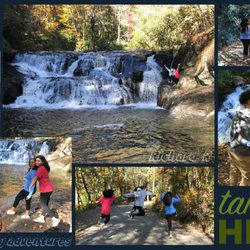
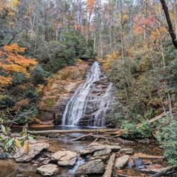
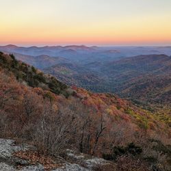
This bridge has a spectacular view of the Toccoa river. Especially in the fall when the leaves are changing color. It is a great destination and family friendly. You can drive up a gravel/dirt road, about 3 miles, then take a short 15 minutes hike to the bridge. The hike is easy to moderate. The bridge do actually swing, so be careful holding your phones while on the bridge.

So the pin on the map will not help you find the place, and the other person's review and suggestion doesn't help with finding it either. This is a nice little place to check out... Although the drive is a little bit more than desired. I've attached a hand written note from a hiker that will help you find the place.... There tends to be so many people lost, the hiker travels around with these directions in his pocket.


8 months ago
Super fun! Easy walk! Kid and pet friendly! We walked our 2 dogs and had no issues! The bridge obviously swings so be careful holding your phone on the bridge taking photos! Great place to skip rocks! read more


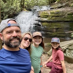
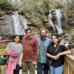
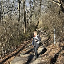
On our recent trip to Blue Ridge, we decided to check out the Toccoa River Swinging Bridge. I am glad we did as it was quite scenic. We pulled in not knowing what to expect. You take a turn off the main highway and you have a few mile drive up the dirt road to get to the actual bridge. I did do this in a front wheel drive car, but a 4 wheel drive truck would be recommended if the conditions were wet or less than ideal. The road is pretty skinny at points and there is definitely not room for two vehicles even though this is not a one way, so one must drive cautiously. Once there, there isn't really any designated parking. You just park wherever you can. The bridge is quite scenic. It looks more stable than it actually is. It sways quite a bit when people are crossing and it isn't quite wide enough for two people to pass without hugging one side, but the view and hikes surrounding the river make it worth it. We spent a few hours here enjoying nature and then headed back. Awesome spot worth checking out. read more


First off the address listed is NOT the correct address. You need to look up Benton Mackaye Trail to find the correct spot. We did a family trip to Blue Ridge & had heard about the Swinging Bridge from my brother. Now, the drive up is not for the faint of heart. It's a one way, bumpy, steep & narrow about 3 mile road. My hubby definitely handled that drive for us. One we made it to the top it's easy to follow the trail. On the trees are white markings leading the way. The bridge itself is magnificent as is the river below. We were fascinated. We also hiked along the river for a bit taking in the views which were spectacular. Absolutely recommend ! From the parking to the bridge it's about 15 minutes. The walk up is not too bad, family friendly. read more


This bridge has a spectacular view of the Toccoa river. Especially in the fall when the leaves are changing color. It is a great destination and family friendly. You can drive up a gravel/dirt road, about 3 miles, then take a short 15 minutes hike to the bridge. The hike is easy to moderate. The bridge do actually swing, so be careful holding your phones while on the bridge. read more


3 years ago
So the pin on the map will not help you find the place, and the other person's review and suggestion doesn't help with finding it either. This is a nice little place to check out... Although the drive is a little bit more than desired. I've attached a hand written note from a hiker that will help you find the place.... There tends to be so many people lost, the hiker travels around with these directions in his pocket. read more

4 years ago
This was a great little place to go visit. Wished we would've known that it was down a dirt road 3 miles lol we drove our motorcycle so that was fun. It's not the best little dirt road either a lot of ruts and things. You walk a little trail to the swinging bridge. Very nice place to visit read more


4 years ago
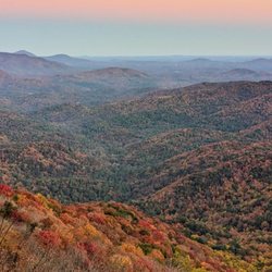
A very pretty 3 mile drive to the parking area and then a short hike to the bridge. We went during fall and the colors and views were spectacular! We would definitely do this again and next time extend our hike beyond the bridge. read more


3 years ago
More info about Swinging Bridge On The Toccoa River
Ask the Community - Swinging Bridge On The Toccoa River


Swinging Bridge On The Toccoa River - hiking - Updated June 2026
Best of Blue Ridge
People found Swinging Bridge On The Toccoa River by searching for…
Things to Do in Blue Ridge, Georgia
Hiking Trails With Waterfalls in Blue Ridge, Georgia
Playgrounds in Blue Ridge, Georgia
Scenic Drive in Blue Ridge, Georgia
Off Road Trails in Blue Ridge, Georgia
Scenic Views in Blue Ridge, Georgia
River Swimming in Blue Ridge, Georgia
Scenic Overlook in Blue Ridge, Georgia
Easy Hikes in Blue Ridge, Georgia
Walking Trails in Blue Ridge, Georgia
View Points in Blue Ridge, Georgia
Parks for Kids in Blue Ridge, Georgia
Public Running Track in Blue Ridge, Georgia
Lookout Points in Blue Ridge, Georgia
Fun Things to Do With Kids in Blue Ridge, Georgia
Places to Take Pictures in Blue Ridge, Georgia
Playgrounds for Kids in Blue Ridge, Georgia
Hiking With Kids in Blue Ridge, Georgia
Baseball Fields in Blue Ridge, Georgia
Public Beaches in Blue Ridge, Georgia
Public Plazas in Blue Ridge, Georgia
Trending Searches in Blue Ridge, GA
Black Owned Nail Salons near Swinging Bridge On The Toccoa River
Boat Rental near Swinging Bridge On The Toccoa River
Cliff Jumping near Swinging Bridge On The Toccoa River
Day Trips near Swinging Bridge On The Toccoa River
Dog Friendly Beaches near Swinging Bridge On The Toccoa River
Fishing Spots near Swinging Bridge On The Toccoa River
Jet Ski Rental near Swinging Bridge On The Toccoa River
Kayak Rental near Swinging Bridge On The Toccoa River
Lakes near Swinging Bridge On The Toccoa River
Lakes & Ponds near Swinging Bridge On The Toccoa River
Off Leash Dog Hiking Trails near Swinging Bridge On The Toccoa River
Outdoor Activities near Swinging Bridge On The Toccoa River
Paddle Boat Rentals near Swinging Bridge On The Toccoa River
Pick Your Own Farms near Swinging Bridge On The Toccoa River
Public Shower near Swinging Bridge On The Toccoa River
River Swimming near Swinging Bridge On The Toccoa River
River Tubing near Swinging Bridge On The Toccoa River
Scenic Overlook near Swinging Bridge On The Toccoa River
Splash Pad near Swinging Bridge On The Toccoa River
Strawberry Picking near Swinging Bridge On The Toccoa River
Swimming Holes near Swinging Bridge On The Toccoa River
Swimming Lakes near Swinging Bridge On The Toccoa River
Watch Sunset near Swinging Bridge On The Toccoa River
Water Parks near Swinging Bridge On The Toccoa River
Waterfalls And Swimming Holes near Swinging Bridge On The Toccoa River
Browse Articles
Browse Nearby
Browse Brands
Related Searches in Blue Ridge, GA
Affordable Kayak Rental Services in Blue Ridge, Georgia
Best Fishing Locations and Guides in Blue Ridge, Georgia
Best Nature Trails for Hiking in Blue Ridge, Georgia
Best Parks for Parties and Events in Blue Ridge, Georgia
Best Places for Horseback Riding in Blue Ridge, Georgia
Best Water Parks for Kids in Blue Ridge, Georgia
Best Waterfalls and Swimming Holes in Blue Ridge, Georgia
Check Out Great Playgrounds in Blue Ridge, Georgia
Check Out Off Road Trails in Blue Ridge, Georgia
Discover Baseball Fields Around Blue Ridge, Georgia
Discover Dog Friendly Trails to Explore in Blue Ridge, Georgia
Discover Lakes & Ponds to Explore in Blue Ridge, Georgia
Discover Popular Photo Spots in Blue Ridge, Georgia
Discover Scenic Mountain Bike Trails Near Blue Ridge, Georgia
Discover Scenic Waterfall Spots in Blue Ridge, Georgia
Discover Soccer Fields in Blue Ridge, Georgia Near You
Discover Top Nature Parks to Visit in Blue Ridge, Georgia
Discover a Hiking Trail in Blue Ridge, Georgia
Discover the Best Beaches in Blue Ridge, Georgia
Discover the Best Night Hike Trails in Blue Ridge, Georgia
Discover the Best Running Track in Blue Ridge, Georgia
Dog-Friendly Hikes With Dogs in Blue Ridge, Georgia
Enjoy Camping Adventures Around Blue Ridge, Georgia
Enjoy Exciting Mountain Biking Adventures in Blue Ridge, Georgia
Enjoy Kayaking Adventures in Blue Ridge, Georgia
Enjoy River Tubing Adventures in Blue Ridge, Georgia
Enjoy Tent Camping Spots Around Blue Ridge, Georgia
Enjoy the Best Picnic Spots and Ideas in Blue Ridge, Georgia
Enjoy the Best Tubing Experiences in Blue Ridge, Georgia
Enjoy the Best Walking Trails in Blue Ridge, Georgia
Exciting Cliff Jumping Spots in Blue Ridge, Georgia
Experience Thrilling White Water Rafting in Blue Ridge, Georgia
Explore Beautiful Botanical Gardens in Blue Ridge, Georgia
Explore Beautiful Parks and Green Spaces in Blue Ridge, Georgia
Explore Bike Rentals Throughout Blue Ridge, Georgia
Explore Easy Hikes Perfect for All in Blue Ridge, Georgia
Explore Family-Friendly Zoos and Wildlife in Blue Ridge, Georgia
Explore Free Picnic Areas Around Blue Ridge, Georgia
Explore Fun Activities to Do in Blue Ridge, Georgia
Explore Parks With Pull Up Bars in Blue Ridge, Georgia
Explore Popular Campgrounds Near Blue Ridge, Georgia
Explore Popular Picnic Areas Around Blue Ridge, Georgia
Explore Popular RV Parks Around Blue Ridge, Georgia
Explore Popular Recreation Centers Around Blue Ridge, Georgia
Explore Popular Scenic Overlook Points in Blue Ridge, Georgia
Explore Popular Scenic Views Near Blue Ridge, Georgia
Explore Popular View Points Around Blue Ridge, Georgia
Explore Scenic Lakes to Visit in Blue Ridge, Georgia