Sycamore Crest Trail Photos


You might also consider
More like Sycamore Crest Trail
Recommended Reviews - Sycamore Crest Trail
Start your review...

Reviews With Photos
")
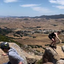
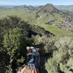
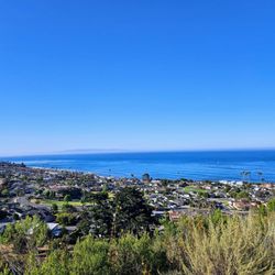
This is one of the best trails I have hiked in quite a while. It came recommended to me from my cousin that is a total outdoors and nature seeker. Her recommendations usually always hit just right for me. There's not direct parking access, so your best bet is to park at the Bob Jones Trail head park and ride lot. That does add a few miles to your whole route, but the alternative is to park illegally in the resort parking lot and risk your car getting towed. But honestly I really recommend parking at the Bob Jones lot because it's good to get a few miles of cardio walking that easy flat paved path before you do the incline of Sycamore Crest Trail. It's a wide dirt path that goes up and ends at the top where you will overlook Avila Beach on one side and Avila Valley on the other. There's a lone swing hanging from a tree on each side. And there are other trails up there as well that will give you even more rigorous workouts. When I got to the top we just sat on the ground and enjoyed the view for awhile. The weather was great and the air is so fresh. I definitely recommend going on a clear day because that makes the whole experience. You can see all the way to Pismo Dunes on one side and Port San Luis at the other. I definitely recommend taking water. I took a pack with extra water, snacks, etc. It's interesting also the muscles you'll feel working on your way up versus the muscles you use on your way down. I felt great afterwards, and look forward to coming and doing this hike again.

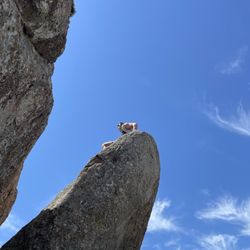
I love the Sycamore Crest Trail! One of the best views of the area, and easy to customize length and difficulty. If you're walking from the Sycamore Hot Springs, you will walk up for about one mile to arrive on top. It's strenuous, but absolutely doable if you're average fit and don't have any health issues. The trail is wide and smooth for your way up. Dogs are allowed on leash! If you have an aggressive dog, better leave him at home, as there's usually a lot of puppies out here. Once you're up top, you can stroll around to enjoy the view, or sit on either of the two swings on either side of the ridge, providing excellent views. I like to go towards the highway across the ridge to get a little workout with many ups and downs, then walking along the Shell Beach trail along the beach, and back up what I call the "firefighter hill" - an EXTREMELY steep portion of the trail that connects Pirate's Cove back with the top of the ridge where you started earlier. You get quite a bit of variation on these trails, or opt to add the Bob Jones trail from the start at Sycamore Springs.


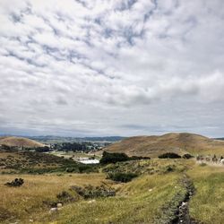
Awesome trail to the top of Ontario Ridge! Park in the Sycamore parking lot and go up the road to the left of the gift center. Stay to the right as you make your way up to the start of the trail. Once you get to the top, go to the right and go up the highest hill for the best views of Avila and SLO! The trail is not closed! There is just a gate in the front saying not to park in front of it. I saw just a few other people on the trail so it was really peaceful and quiet. I'll be back again and again!!


Super cool trail!!! Nice wide path, could easily get a stroller up it if your strong enough to push-up an incline! We parked at the resort, but what appeared to be a manager came out and made it very clear that unless you are a hotel guest, you may not park there! I had 4 kids under 10 with me, and he was nice enough to allow it this one time!!! This hike was one of the prettiest hikes I've been on!!! The views from the top are spectacular!!! The swing on the top is beautiful and a great picture spot!!! Will most definitely go again soon!!!!


This a fun, short hike up to a great and vantage view point of Avila Bay and Port San Luis. I was checking the Sycamore Mineral Springs resort out and saw this trail and decided to go for it. Total mileage out and back is only 1.5 miles but it's a great workout. It was a pretty warm day and I worked up a sweat pretty quickly. Definitely steep but I appreciated the climb. I made it up to the top pretty fast so I was all happy with myself. The elevation gain is quick so be prepared. Lots of pretty views going up but at the top by far is the best. I loved all the gorgeous oak trees that provided some much needed shade along the trail. Once you are at the top, the view is pretty epic and you will want to linger. I could see the Pismo Dunes to my left and the beautiful bay and Port San Luis to my right. Should you desire to continue your hike then head left hike along the Ontario Ridge. Just can't beat the Central Coast of California! read more


PARK AT THE BOB JONES PARKING LOT.. From the public parking lot the total length of this hike is 4.2 miles. Only 1 mile of that is up a tough gravel road to a viewpoint. That one mile up is pretty stressful on a hot day so be prepared to take multiple breaks if you're not in great physical shape. Use an app like alltrails to make sure you navigate to the Sycamore Mineral Springs Resort and to find the actual Sycamore Crest trailhead. You'll have to walk past hotel rooms and walk up the resorts road to get to the trailhead. Are there better hikes than this? Yes.. You hike this trail to get a nice view of Avila bay. - Bring good shoes. The gravely road can be slippery on the way down if you use regular tennis shoes. read more


This is one of the best trails I have hiked in quite a while. It came recommended to me from my cousin that is a total outdoors and nature seeker. Her recommendations usually always hit just right for me. There's not direct parking access, so your best bet is to park at the Bob Jones Trail head park and ride lot. That does add a few miles to your whole route, but the alternative is to park illegally in the resort parking lot and risk your car getting towed. But honestly I really recommend parking at the Bob Jones lot because it's good to get a few miles of cardio walking that easy flat paved path before you do the incline of Sycamore Crest Trail. It's a wide dirt path that goes up and ends at the top where you will overlook Avila Beach on one side and Avila Valley on the other. There's a lone swing hanging from a tree on each side. And there are other trails up there as well that will give you even more rigorous workouts. When I got to the top we just sat on the ground and enjoyed the view for awhile. The weather was great and the air is so fresh. I definitely recommend going on a clear day because that makes the whole experience. You can see all the way to Pismo Dunes on one side and Port San Luis at the other. I definitely recommend taking water. I took a pack with extra water, snacks, etc. It's interesting also the muscles you'll feel working on your way up versus the muscles you use on your way down. I felt great afterwards, and look forward to coming and doing this hike again. read more
 - Hiking Near Me")


 did this trail today - Hiking Near Me")


 - Hiking Near Me")
I love the Sycamore Crest Trail! One of the best views of the area, and easy to customize length and difficulty. If you're walking from the Sycamore Hot Springs, you will walk up for about one mile to arrive on top. It's strenuous, but absolutely doable if you're average fit and don't have any health issues. The trail is wide and smooth for your way up. Dogs are allowed on leash! If you have an aggressive dog, better leave him at home, as there's usually a lot of puppies out here. Once you're up top, you can stroll around to enjoy the view, or sit on either of the two swings on either side of the ridge, providing excellent views. I like to go towards the highway across the ridge to get a little workout with many ups and downs, then walking along the Shell Beach trail along the beach, and back up what I call the "firefighter hill" - an EXTREMELY steep portion of the trail that connects Pirate's Cove back with the top of the ridge where you started earlier. You get quite a bit of variation on these trails, or opt to add the Bob Jones trail from the start at Sycamore Springs. read more


 - Hiking Near Me")


Awesome trail to the top of Ontario Ridge! Park in the Sycamore parking lot and go up the road to the left of the gift center. Stay to the right as you make your way up to the start of the trail. Once you get to the top, go to the right and go up the highest hill for the best views of Avila and SLO! The trail is not closed! There is just a gate in the front saying not to park in front of it. I saw just a few other people on the trail so it was really peaceful and quiet. I'll be back again and again!! read more


Awesome uphill hike. Sadly it was overcast so couldn't see the view or ocean from the top, but a great way to start our day. Surrounded by lush trees, nice incline, and beautiful picture spots. There's even a swing attached to a large tree which overlooks the ocean view without the fog. read more


8 years ago
Went on a super hot day, but still loved it! Bring water and watch out for poison oak. Friendly hikers on the trail. Beautiful trees and vistas. Pretty magical tree swing, across the trail from a majestic, photogenic oak overlooking the boundless blue. read more


8 years ago
10 years ago
Super cool trail!!! Nice wide path, could easily get a stroller up it if your strong enough to push-up an incline! We parked at the resort, but what appeared to be a manager came out and made it very clear that unless you are a hotel guest, you may not park there! I had 4 kids under 10 with me, and he was nice enough to allow it this one time!!! This hike was one of the prettiest hikes I've been on!!! The views from the top are spectacular!!! The swing on the top is beautiful and a great picture spot!!! Will most definitely go again soon!!!! read more


10 years ago
We stayed at Sycamore Hot Spring Resort and they told us about this trail. It's a 2 mile hike (round trip) and you'll get a great view of Avila Beach when you make it to the top of the hill. It was challenging for my 4 year old but she made it without any help. read more


14 years ago
10 years ago
Awesome views! If I can do this with a couole of stops to catch my breath, anyone in good shape should be able to do it without a problem. read more


More info about Sycamore Crest Trail
San Luis Obispo, CA 93405
Directions
Hours
Indoor Amenities
Outdoor Amenities
Ask the Community - Sycamore Crest Trail
Review Highlights - Sycamore Crest Trail
You might also consider


Why does Yelp recommend reviews?
1 review that is not currently recommended
The reviews below are not factored into the business's overall star rating.
12 years ago
Sycamore Crest Trail - hiking - Updated July 2026
Best of San Luis Obispo
People found Sycamore Crest Trail by searching for…
Hot Springs in San Luis Obispo, California
Beaches in San Luis Obispo, California
Hiking Trails in San Luis Obispo, California
Things to Do in San Luis Obispo, California
Dog Friendly Beaches in San Luis Obispo, California
Dog Friendly Hiking Trails in San Luis Obispo, California
Parks in San Luis Obispo, California
Places to Take Pictures in San Luis Obispo, California
Walking Trails in San Luis Obispo, California
Beautiful Views in San Luis Obispo, California
Sand Dunes in San Luis Obispo, California
Things to Do on a Rainy Day in San Luis Obispo, California
Dog Friendly Things to Do in San Luis Obispo, California
Scenic View in San Luis Obispo, California
Easy Hikes in San Luis Obispo, California
View Points in San Luis Obispo, California
Playgrounds in San Luis Obispo, California
Trails in San Luis Obispo, California
Bridge in San Luis Obispo, California
Photo Spots in San Luis Obispo, California
Hiking With Kids in San Luis Obispo, California
Kid Friendly in San Luis Obispo, California
Trending Searches in San Luis Obispo, CA
4th Of July Fireworks in San Luis Obispo, CA
Boat Rental in San Luis Obispo, CA
Cliff Jumping in San Luis Obispo, CA
Day Trips in San Luis Obispo, CA
Fireworks in San Luis Obispo, CA
Jet Ski Rental in San Luis Obispo, CA
Kayak Rental in San Luis Obispo, CA
Lakes & Ponds in San Luis Obispo, CA
Outdoor Activities in San Luis Obispo, CA
Public Pools in San Luis Obispo, CA
Public Shower in San Luis Obispo, CA
River Swimming in San Luis Obispo, CA
Rock Quarry in San Luis Obispo, CA
Scenic Night View in San Luis Obispo, CA
Scenic Overlook in San Luis Obispo, CA
Secluded Spots in San Luis Obispo, CA
Soccer Store in San Luis Obispo, CA
Splash Pad in San Luis Obispo, CA
Strawberry Picking in San Luis Obispo, CA
Sunrise View in San Luis Obispo, CA
Swimming Holes in San Luis Obispo, CA
Swimming Lakes in San Luis Obispo, CA
U Pick Farms in San Luis Obispo, CA
Watch Sunset in San Luis Obispo, CA
Browse Articles
Browse Nearby
BEST of San Luis Obispo, California Coffee near Sycamore Crest Trail
BEST of San Luis Obispo, California Restaurants near Sycamore Crest Trail
BEST of San Luis Obispo, California Things to Do near Sycamore Crest Trail
BEST of San Luis Obispo, California Walking Trails near Sycamore Crest Trail
BEST of San Luis Obispo, California Parks near Sycamore Crest Trail
BEST of San Luis Obispo, California Breakfast near Sycamore Crest Trail
BEST of San Luis Obispo, California Campgrounds near Sycamore Crest Trail
BEST of San Luis Obispo, California Hot Springs near Sycamore Crest Trail
BEST of San Luis Obispo, California Caves near Sycamore Crest Trail
Browse Brands
Related Searches in San Luis Obispo, CA
Affordable Kayak Rental Services in San Luis Obispo, California
Best Fishing Locations and Guides in San Luis Obispo, California
Best Places for Horseback Riding in San Luis Obispo, California
Best Places for Stunning Views in San Luis Obispo, California
Check Out Off Road Trails in San Luis Obispo, California
Discover Dog Friendly Trails to Explore in San Luis Obispo, California
Discover Scenic Mountain Bike Trails Near San Luis Obispo, California
Discover Scenic Waterfall Spots in San Luis Obispo, California
Discover Top State Parks to Visit in San Luis Obispo, California
Discover a Hiking Trail in San Luis Obispo, California
Discover the Best Night Hike Trails in San Luis Obispo, California
Dog-Friendly Hikes With Dogs in San Luis Obispo, California
Enjoy Camping Adventures Around San Luis Obispo, California
Enjoy Exciting Mountain Biking Adventures in San Luis Obispo, California
Enjoy Kayaking Adventures in San Luis Obispo, California
Enjoy Tent Camping Spots Around San Luis Obispo, California
Enjoy a Beautiful Waterfall Hike in San Luis Obispo, California
Enjoy the Best Picnic Spots and Ideas in San Luis Obispo, California
Enjoy the Best Walking Trails in San Luis Obispo, California
Experience Thrilling White Water Rafting in San Luis Obispo, California
Explore Beautiful Parks and Green Spaces in San Luis Obispo, California
Explore Easy Hikes Perfect for All in San Luis Obispo, California
Explore Fun Activities to Do in San Luis Obispo, California
Explore Popular Campgrounds Near San Luis Obispo, California
Explore Top Dog Parks in San Luis Obispo, California Near You
Explore the Best Beach Spots in San Luis Obispo, California
Explore the Best Boating Spots in San Luis Obispo, California
Explore the Best Trail Options in San Luis Obispo, California
Family Friendly Hiking With Kids in San Luis Obispo, California
Find Beautiful Views in San Luis Obispo, California
Find Popular Ziplining Spots Around San Luis Obispo, California
Find the Best Playgrounds to Visit in San Luis Obispo, California
Find the Best Scenic View Locations in San Luis Obispo, California
Great Places to Walk in San Luis Obispo, California
Hiking Trails With Waterfalls in San Luis Obispo, California
Off Leash Dog Hiking Trails in San Luis Obispo, California
Plan a Scenic Drive Route Near San Luis Obispo, California
Popular Outdoor Activities to Try in San Luis Obispo, California
Popular Picnic Spots to Visit in San Luis Obispo, California
Popular Things to Do in San Luis Obispo, California
Safe River Swimming Areas in San Luis Obispo, California
Safe and Fun Parks for Kids in San Luis Obispo, California
Top Paddleboarding Activities in San Luis Obispo, California
Top Places for Snorkeling in San Luis Obispo, California
Top Playgrounds for Kids to Enjoy in San Luis Obispo, California
Top Running Trails to Explore in San Luis Obispo, California
Top Swimming Lakes to Enjoy in San Luis Obispo, California
Top Swimming Spots and Pools in San Luis Obispo, California
Top Things to Do With Kids in San Luis Obispo, California
Walk Dog Friendly Hiking Trails in San Luis Obispo, California