
West Wing Mountain Trail Photos


You might also consider
More like West Wing Mountain Trail
Recommended Reviews - West Wing Mountain Trail
Start your review...

Reviews With Photos

My second time here. I highly recommend this hike for beginners. I've never hike before and hike twice over here so far. With social distance in mind, this hiking trail is the perfect one to take. I hardly see anyone. Don't get me wrong, people do come here but about a handful and it's always a solo or just a couples hiking. I feel like getting up is easy then going down. I've trip on loose pebbles twice. Scared the crap out of. I do recommend going solo but just be alert. Take your time getting up and down the path. For my two hours trip up and down, I constantly stop, take a sip of water and just breath in and out to catch my breath and go again. There are many path to take and there is a marker that tells you if you want the difficult or easy route to go further. Yesterday was my first hike and I was almost to the top but got scared. Today I reached two different top so I'm so happy that I came, I saw and I conquered it! It was not blazing hot so I was find with two bottles of water but I think once weather change, bring three.


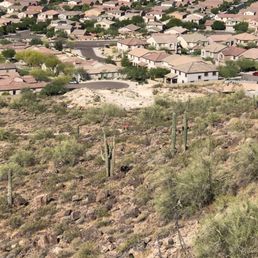
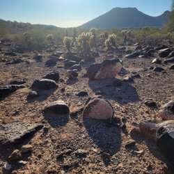
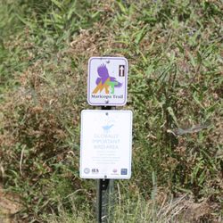
This trail has some nice 360 degree views and is a bit of a challenge. The trail is rocky and has a lot of loose pebbles. I suggest hiking poles for those less stable on their feet. There is an opportunity at the first saddle to go to the left for a small rock climbing excursion. In order to do the full loop from the parking area allow for enough time to do around 5 plus miles. The green rocks were really beautiful. The trail is dog friendly but there is a lot of cactus near the beginning. The parking area is the park and then you must cross the road at the 4 way stop by the small school and follow the trail markers north. The start of the trail before the actual mountain cuts through the neighborhood. There are bathrooms and water at the park but nothing at the actual start of the trailhead
The mountain is right behind my house so I had to try it. It was a group of us. We looked at the map and it looked like about a 3 mile hike. I would say this is an advanced hike. There are many steep climbs and drastic declines where you are jumping down. The paths are rocky and and more natural. It ended up being 3.6 miles for the whole two mountains. Now doing it, I saw there was a way to do a more difficult path but shorten the distance probably be 2 miles if I want to do a shorter but even more challenging hike. It's a good mountain to hike for the people in the area.

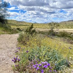
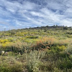
Lovely long trail with many different paths in the northwest valley! This beautiful trail can keep you going for hours! Many different route of varied difficulties. Only downside is that the trails are quite narrow at parts, which can be a little intimidating, that said love the flora and the desert views. Parking can be a bit crazy. I usually park in the church lot.

I love hiking, and this is a great spot. It's 4 miles total - including all of the different trail directions you can go (see picture I uploaded). I have mostly stuck to the Golden Cliffs Trial and have really enjoyed it. It's a great workout! I definitely felt the burn with the incline. Awesome views from up top, too. Remember to never hike alone and to not go when it is hot! read more
5 years ago
My second time here. I highly recommend this hike for beginners. I've never hike before and hike twice over here so far. With social distance in mind, this hiking trail is the perfect one to take. I hardly see anyone. Don't get me wrong, people do come here but about a handful and it's always a solo or just a couples hiking. I feel like getting up is easy then going down. I've trip on loose pebbles twice. Scared the crap out of. I do recommend going solo but just be alert. Take your time getting up and down the path. For my two hours trip up and down, I constantly stop, take a sip of water and just breath in and out to catch my breath and go again. There are many path to take and there is a marker that tells you if you want the difficult or easy route to go further. Yesterday was my first hike and I was almost to the top but got scared. Today I reached two different top so I'm so happy that I came, I saw and I conquered it! It was not blazing hot so I was find with two bottles of water but I think once weather change, bring three. read more


3 years ago
Short hike with cool views. Pretty, rocky trail. Hike it in a counter clockwise loop for maximum gain. Park at West Wing Park and walk the few blocks to the trailhead. No parking at the trailhead buried in a neighborhood. read more


4 years ago
This trail has some nice 360 degree views and is a bit of a challenge. The trail is rocky and has a lot of loose pebbles. I suggest hiking poles for those less stable on their feet. There is an opportunity at the first saddle to go to the left for a small rock climbing excursion. In order to do the full loop from the parking area allow for enough time to do around 5 plus miles. The green rocks were really beautiful. The trail is dog friendly but there is a lot of cactus near the beginning. The parking area is the park and then you must cross the road at the 4 way stop by the small school and follow the trail markers north. The start of the trail before the actual mountain cuts through the neighborhood. There are bathrooms and water at the park but nothing at the actual start of the trailhead read more


9 years ago
The mountain is right behind my house so I had to try it. It was a group of us. We looked at the map and it looked like about a 3 mile hike. I would say this is an advanced hike. There are many steep climbs and drastic declines where you are jumping down. The paths are rocky and and more natural. It ended up being 3.6 miles for the whole two mountains. Now doing it, I saw there was a way to do a more difficult path but shorten the distance probably be 2 miles if I want to do a shorter but even more challenging hike. It's a good mountain to hike for the people in the area. read more


Lovely long trail with many different paths in the northwest valley! This beautiful trail can keep you going for hours! Many different route of varied difficulties. Only downside is that the trails are quite narrow at parts, which can be a little intimidating, that said love the flora and the desert views. Parking can be a bit crazy. I usually park in the church lot. read more

11 years ago
A little hard to find for out of towners. Drive in back of the school and look for the chain link fence where the trail behind. Nice warm up to hike in civilization ! 4.2 miles some steep incline. Beautiful views and interesting plants. read more


More info about West Wing Mountain Trail
27008 N High Desert Dr
Peoria, AZ 85383
Directions
Hours
Outdoor Amenities
Ask the Community - West Wing Mountain Trail
Review Highlights - West Wing Mountain Trail


West Wing Mountain Trail - hiking - Updated July 2026
Best of Peoria
People found West Wing Mountain Trail by searching for…
Trending Searches in Peoria, AZ
Boat Tours near West Wing Mountain Trail
Cliff Jumping near West Wing Mountain Trail
Cruising Spots near West Wing Mountain Trail
Day Trips near West Wing Mountain Trail
Dog Friendly Trails near West Wing Mountain Trail
Jet Ski Rental near West Wing Mountain Trail
Kayak Rental near West Wing Mountain Trail
Kids Activities Indoor near West Wing Mountain Trail
Lakes near West Wing Mountain Trail
Off Road Trails near West Wing Mountain Trail
Outdoor Activities near West Wing Mountain Trail
Peach Picking near West Wing Mountain Trail
Places To Walk Around near West Wing Mountain Trail
Public Shower near West Wing Mountain Trail
Rainy Day Activities near West Wing Mountain Trail
River Swimming near West Wing Mountain Trail
River Tubing near West Wing Mountain Trail
Rock Quarry near West Wing Mountain Trail
Scenic Night View near West Wing Mountain Trail
Scenic Overlook near West Wing Mountain Trail
Soccer Store near West Wing Mountain Trail
Sunrise View near West Wing Mountain Trail
Swimming Holes near West Wing Mountain Trail
Swimming Lakes near West Wing Mountain Trail
U Pick Farms near West Wing Mountain Trail
Watch Sunset near West Wing Mountain Trail
Browse Articles
Browse Nearby
BEST of Peoria, Arizona Coffee near West Wing Mountain Trail
BEST of Peoria, Arizona Restaurants near West Wing Mountain Trail
BEST of Peoria, Arizona Things to Do near West Wing Mountain Trail
BEST of Peoria, Arizona Parks near West Wing Mountain Trail
BEST of Peoria, Arizona Breakfast near West Wing Mountain Trail
Browse Brands
Related Searches in Peoria, AZ
Affordable Kayak Rental Services in Peoria, Arizona
Best Dog Hiking Trails Around Peoria, Arizona
Best Fishing Locations and Guides in Peoria, Arizona
Best Nature Trails for Hiking in Peoria, Arizona
Best Places for Horseback Riding in Peoria, Arizona
Best Sightseeing Experiences Available in Peoria, Arizona
Check Out Off Road Trails in Peoria, Arizona
Discover Dog Friendly Trails to Explore in Peoria, Arizona
Discover Easy Hiking Trails Near Peoria, Arizona
Discover Kid Friendly Hiking Trails in Peoria, Arizona
Discover Popular Bike Trails in Peoria, Arizona
Discover Walking Parks in Peoria, Arizona Near You
Discover a Hiking Trail in Peoria, Arizona
Discover the Best Night Hike Trails in Peoria, Arizona
Dog-Friendly Hikes With Dogs in Peoria, Arizona
Enjoy Camping Adventures Around Peoria, Arizona
Enjoy Kayaking Adventures in Peoria, Arizona
Enjoy Off Leash Dog Hikes in Peoria, Arizona
Enjoy Scenic Places to Walk in Peoria, Arizona
Enjoy Tent Camping Spots Around Peoria, Arizona
Enjoy a Beautiful Waterfall Hike in Peoria, Arizona
Enjoy the Best Walking Path in Peoria, Arizona
Enjoy the Best Walking Trails in Peoria, Arizona
Experience Stunning Sunset Views in Peoria, Arizona
Explore Beautiful Parks and Green Spaces in Peoria, Arizona
Explore Easy Hikes Perfect for All in Peoria, Arizona
Explore Fun Activities to Do in Peoria, Arizona
Explore Popular Campgrounds Near Peoria, Arizona
Explore Top Dog Parks in Peoria, Arizona Near You
Family Friendly Hiking With Kids in Peoria, Arizona
Find Cozy Camping Cabins in Peoria, Arizona
Find Top-Rated Waterfalls in Peoria, Arizona Now
Find the Best Parks for Picnics in Peoria, Arizona
Hiking Trails With Waterfalls in Peoria, Arizona
Off Leash Dog Hiking Trails in Peoria, Arizona
Perfect Spots to Watch Sunset in Peoria, Arizona
Plan a Scenic Drive Route Near Peoria, Arizona
Popular Outdoor Activities to Try in Peoria, Arizona
Popular Picnic Spots to Visit in Peoria, Arizona
Popular Waterfall Hiking Trails in Peoria, Arizona
Safe and Fun Parks for Kids in Peoria, Arizona
Top Hiking Trails to Explore in Peoria, Arizona
Top Playgrounds for Kids to Enjoy in Peoria, Arizona
Top Running Trails to Explore in Peoria, Arizona
Top Swimming Lakes to Enjoy in Peoria, Arizona
Top Swimming Spots and Pools in Peoria, Arizona
Top-Rated Camping Sites in Peoria, Arizona


