Castle Rock Trailhead Photos


You might also consider
More like Castle Rock Trailhead
Recommended Reviews - Castle Rock Trailhead
Start your review...

Reviews With Photos

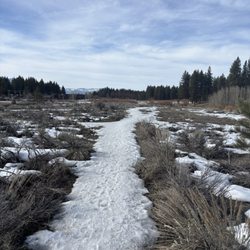
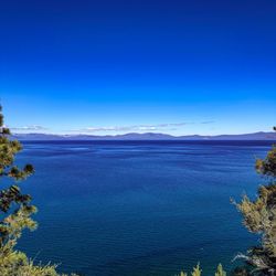
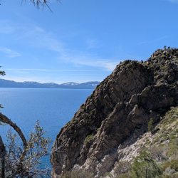
Went up on a Sunday afternoon deep in the heart of summer! There was construction going on at the Trail head so I had to park down the street. The trail head leads you to Castle rock, or puts you right on the Tahoe rim Trail. The group I was with went for the castle rock Trail. It's a fairly easy hike, very short and practically flat. Just about anybody can handle it. There are Falcons nesting during their season, so be aware and be respectful of nature. If they get upset, we could lose some! Make sure you bring mosquito repellent! The view from the rock is spectacular! Gorgeous overlook of Lake Tahoe! Well worth the drive, and the hike!

This was amazing!! What a fantastic was to get out and explore our own backyard. This trail is very well groomed and maintained, wasn't hard to navigate the trail as all the signs were well marked, plenty of views, dog friendly, lots of shade, and I loved the end pay off and the beautiful view of Lake Tahoe. 100% will come back and bring my family and friends. This trail head is getting a new parking lot and many options to other longer hikes too if you wish. Already looking forward to my next hike! Directions:* but always check your map for your best route. From South Reno: Take 580 South and merge onto 395 S in Carson City. Take 395 S to NV757/Muller Lane and turn RIGHT. Take NV 757 to NV206 and turn LEFT. Turn RIGHT onto NV207/Kingsbury Grade, and follow until N. Benjamin Rd and turn RIGHT and continue onto Andria Dr. This will dead end into the trailhead. From Stateline, NV: Head up Kingsbury Grade (RT 207) for 2.8 miles. Turn left on N. Benjamin and continue onto Andria Dr and it eventually dead ends into the trailhead

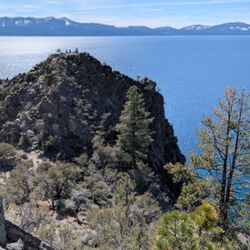
One of my favorite hikes and climbing areas. Has a beautiful view of all of South Lake Tahoe. The climbing is very good for beginners and the hike itself is very easy with only a small amount of steepness near the end. You can also make a great loop hike if you continue North on the Tahoe Rim Trail and use the cutoff trail to get back to the parking lot.


What a beautiful hike and so easy to get to. Parking is limited to street side parking while they are completing construction of the new parking lot! The castle rock loop trail was a fairly simple hike. Partially shaded with so many astonishing views. I hiked it with my 5 year old son and he did well until about halfway back to the car. I wouldn't recommend being any littles who aren't used to hiking. No restrooms at this time but I believe it will be in the future after the parking lot remodel.

1 year ago


7 years ago
A true hidden gem with an epic payoff a short walk from the trailhead! Raise your hand if you knew about this trail before reading this review. If you've got your hand up, pat yourself on the back because this is tucked away in a place only a true local could know about. We tackled this trail with the help of friends from Gear Hut and Sierra Club, who made sure we knew how to safely navigate the terrain and find our way. The parking area by the trailhead is currently under construction, making way for lots of folks in the near future. There are some rudimentary maps hung on construction cones outside the fencing, but they're not totally helpful. The real map of the area is inside the fence on the main board, and it's absolute worth finding before you head off. The hike to castle Rock is short and sweet if you go direct. There's a short scramble at the end that puts you on a nice lookout over the lake between Zephyr Cove and Stateline. Along the way there are some other lookouts that view over the forest between the peaks of the mountains. We spotted falcons fighting mid air and quite a few curious chipmunks along the way. The trail is nicely shaded too! From Castle Rock you can follow the loop for a nice leisurely 3 mile jaunt through the forest. The shade means you can do this trail any time of the day and without much elevation gain, it's great for kids and dogs too. Next time I visit I'm doing the loop in reverse so Castle Rock becomes a much needed rest point. This is a trail I hope to take lots of friends on in the future! read more


Went up on a Sunday afternoon deep in the heart of summer! There was construction going on at the Trail head so I had to park down the street. The trail head leads you to Castle rock, or puts you right on the Tahoe rim Trail. The group I was with went for the castle rock Trail. It's a fairly easy hike, very short and practically flat. Just about anybody can handle it. There are Falcons nesting during their season, so be aware and be respectful of nature. If they get upset, we could lose some! Make sure you bring mosquito repellent! The view from the rock is spectacular! Gorgeous overlook of Lake Tahoe! Well worth the drive, and the hike! read more

7 years ago
This was amazing!! What a fantastic was to get out and explore our own backyard. This trail is very well groomed and maintained, wasn't hard to navigate the trail as all the signs were well marked, plenty of views, dog friendly, lots of shade, and I loved the end pay off and the beautiful view of Lake Tahoe. 100% will come back and bring my family and friends. This trail head is getting a new parking lot and many options to other longer hikes too if you wish. Already looking forward to my next hike! Directions:* but always check your map for your best route. From South Reno: Take 580 South and merge onto 395 S in Carson City. Take 395 S to NV757/Muller Lane and turn RIGHT. Take NV 757 to NV206 and turn LEFT. Turn RIGHT onto NV207/Kingsbury Grade, and follow until N. Benjamin Rd and turn RIGHT and continue onto Andria Dr. This will dead end into the trailhead. From Stateline, NV: Head up Kingsbury Grade (RT 207) for 2.8 miles. Turn left on N. Benjamin and continue onto Andria Dr and it eventually dead ends into the trailhead read more

7 years ago
One of my favorite hikes and climbing areas. Has a beautiful view of all of South Lake Tahoe. The climbing is very good for beginners and the hike itself is very easy with only a small amount of steepness near the end. You can also make a great loop hike if you continue North on the Tahoe Rim Trail and use the cutoff trail to get back to the parking lot. read more


6 years ago
A nice fun hike on a trailhead with ample parking easily marked signs, that takes about 1 hour, is not too difficult for beginners, and ends with a nice view of the Lake. This will be one of the highlights of your visit to Lake Tahoe. Highly recommended. read more


What a beautiful hike and so easy to get to. Parking is limited to street side parking while they are completing construction of the new parking lot! The castle rock loop trail was a fairly simple hike. Partially shaded with so many astonishing views. I hiked it with my 5 year old son and he did well until about halfway back to the car. I wouldn't recommend being any littles who aren't used to hiking. No restrooms at this time but I believe it will be in the future after the parking lot remodel. read more


7 years ago
The hike today was very well organized & guided by Yelp, Nutrient, Gearhut, & Sierra Club. Directions to trailhead are accurate, however, the trailhead parking lot is under construction. There is street parking available but currently no bathroom access. The trail is well-groomed and it's a fairly easy hike with a big payoff/view!! Definitely, recommend! read more


7 years ago
7 years ago
More info about Castle Rock Trailhead
Genoa Peak Rd
Zephyr Cove, NV 89448
Directions
Hours
Indoor Amenities
Outdoor Amenities
Ask the Community - Castle Rock Trailhead
Review Highlights - Castle Rock Trailhead
You might also consider


Castle Rock Trailhead - hiking - Updated June 2026
Best of Zephyr Cove
People found Castle Rock Trailhead by searching for…
Things to Do in Zephyr Cove, Nevada
Hiking Trails in Zephyr Cove, Nevada
Free Parking in Zephyr Cove, Nevada
Natural Hot Springs in Zephyr Cove, Nevada
Rock Climbing in Zephyr Cove, Nevada
Secret Spots in Zephyr Cove, Nevada
Walking Trails in Zephyr Cove, Nevada
Easy Hikes in Zephyr Cove, Nevada
Dog Friendly Trails in Zephyr Cove, Nevada
Scenic Overlook in Zephyr Cove, Nevada
View Points in Zephyr Cove, Nevada
Parks for Kids in Zephyr Cove, Nevada
Fun Things to Do With Kids in Zephyr Cove, Nevada
Lookout Points in Zephyr Cove, Nevada
Dog Friendly Things to Do in Zephyr Cove, Nevada
Night View in Zephyr Cove, Nevada
Hikes With Dogs in Zephyr Cove, Nevada
Running Trails in Zephyr Cove, Nevada
Waterfalls in Zephyr Cove, Nevada
Trending Searches in Zephyr Cove, NV
Bait And Tackle Shop near Castle Rock Trailhead
Beaches near Castle Rock Trailhead
Boat Rental near Castle Rock Trailhead
Cliff Jumping near Castle Rock Trailhead
Day Trips near Castle Rock Trailhead
Dog Friendly Trails near Castle Rock Trailhead
Fishing Spots near Castle Rock Trailhead
Free Kids Activities near Castle Rock Trailhead
Jet Ski Rental near Castle Rock Trailhead
Kayak Rental near Castle Rock Trailhead
Lakes & Ponds near Castle Rock Trailhead
Off Road Trails near Castle Rock Trailhead
Outdoor Activities near Castle Rock Trailhead
Pick Your Own Farms near Castle Rock Trailhead
Public Shower near Castle Rock Trailhead
Rock Quarry near Castle Rock Trailhead
Scenic Drive near Castle Rock Trailhead
Secluded Spots near Castle Rock Trailhead
Soccer Store near Castle Rock Trailhead
Splash Pad near Castle Rock Trailhead
Sunrise View near Castle Rock Trailhead
Swimming Holes near Castle Rock Trailhead
Swimming Lakes near Castle Rock Trailhead
Swimming Pools near Castle Rock Trailhead
Watch Sunset near Castle Rock Trailhead
Browse Articles
Browse Nearby
BEST of Zephyr Cove, Nevada Restaurants near Castle Rock Trailhead
BEST of Zephyr Cove, Nevada Coffee near Castle Rock Trailhead
BEST of Zephyr Cove, Nevada Walking Trails near Castle Rock Trailhead
BEST of Zephyr Cove, Nevada Things to Do near Castle Rock Trailhead
BEST of Zephyr Cove, Nevada Parks near Castle Rock Trailhead
BEST of Zephyr Cove, Nevada Breakfast near Castle Rock Trailhead
BEST of Zephyr Cove, Nevada Hot Springs near Castle Rock Trailhead
BEST of Zephyr Cove, Nevada Sledding near Castle Rock Trailhead
BEST of Zephyr Cove, Nevada Campgrounds near Castle Rock Trailhead
Browse Brands
Related Searches in Zephyr Cove, NV
Affordable Kayak Rental Services in Zephyr Cove, Nevada
Best Fishing Locations and Guides in Zephyr Cove, Nevada
Best Places for Horseback Riding in Zephyr Cove, Nevada
Best Sledding Spots and Fun in Zephyr Cove, Nevada
Best Waterfalls and Swimming Holes in Zephyr Cove, Nevada
Check Out Off Road Trails in Zephyr Cove, Nevada
Discover Dog Friendly Trails to Explore in Zephyr Cove, Nevada
Discover Kid Friendly Hiking Trails in Zephyr Cove, Nevada
Discover Scenic Mountain Bike Trails Near Zephyr Cove, Nevada
Discover Scenic Waterfall Spots in Zephyr Cove, Nevada
Discover a Hiking Trail in Zephyr Cove, Nevada
Discover the Best Night Hike Trails in Zephyr Cove, Nevada
Dog-Friendly Hikes With Dogs in Zephyr Cove, Nevada
Enjoy Camping Adventures Around Zephyr Cove, Nevada
Enjoy Kayaking Adventures in Zephyr Cove, Nevada
Enjoy Tent Camping Spots Around Zephyr Cove, Nevada
Enjoy a Beautiful Waterfall Hike in Zephyr Cove, Nevada
Enjoy the Best Picnic Spots and Ideas in Zephyr Cove, Nevada
Enjoy the Best Tubing Experiences in Zephyr Cove, Nevada
Enjoy the Best Walking Trails in Zephyr Cove, Nevada
Exciting Cliff Jumping Spots in Zephyr Cove, Nevada
Experience Thrilling White Water Rafting in Zephyr Cove, Nevada
Explore Beautiful Parks and Green Spaces in Zephyr Cove, Nevada
Explore Easy Hikes Perfect for All in Zephyr Cove, Nevada
Explore Fun Activities to Do in Zephyr Cove, Nevada
Explore Nature Spots Around Zephyr Cove, Nevada
Explore Popular Campgrounds Near Zephyr Cove, Nevada
Explore the Best Beach Spots in Zephyr Cove, Nevada
Explore the Best Swimming Holes Around Zephyr Cove, Nevada
Explore the Best Trail Options in Zephyr Cove, Nevada
Family Friendly Hiking With Kids in Zephyr Cove, Nevada
Find Beautiful Views in Zephyr Cove, Nevada
Find Popular Ziplining Spots Around Zephyr Cove, Nevada
Find the Best Scenic View Locations in Zephyr Cove, Nevada
Hike the Popular Waterfall Trail in Zephyr Cove, Nevada
Hiking Trails With Waterfalls in Zephyr Cove, Nevada
Off Leash Dog Hiking Trails in Zephyr Cove, Nevada
Plan a Scenic Drive Route Near Zephyr Cove, Nevada
Popular Outdoor Activities to Try in Zephyr Cove, Nevada
Popular Picnic Spots to Visit in Zephyr Cove, Nevada
Popular Things to Do in Zephyr Cove, Nevada
Safe River Swimming Areas in Zephyr Cove, Nevada
Safe and Fun Parks for Kids in Zephyr Cove, Nevada
Top Playgrounds for Kids to Enjoy in Zephyr Cove, Nevada
Top Running Trails to Explore in Zephyr Cove, Nevada
Top Swimming Lakes to Enjoy in Zephyr Cove, Nevada
Top Swimming Spots and Pools in Zephyr Cove, Nevada
Top Things to Do With Kids in Zephyr Cove, Nevada