Cave Rock Trail Head Glenbrook NV Photos


You might also consider
More like Cave Rock Trail Head Glenbrook NV
Recommended Reviews - Cave Rock Trail Head Glenbrook NV
Start your review...

Reviews With Photos


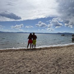
I had no expectations for this, but all of the locals we asked for top spots to visit at sunset recommended Cave Rock! We had been driving under the rock and thru the tunnel to get from the south to the east side, but I had no idea you could actually hike to the top of the rock!!! If you love adventure, this is a quick, 15 minute hike! The views are incredible. It's an amazing view and an incredible sensation once you get to the top. The feeling is indescribable. You are HIGH up. There are no railings whatsoever. It was the most liberating feeling for me. An absolute must when you're in Tahoe!

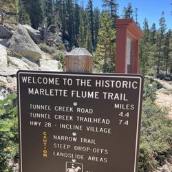
Stunning panaoramic views atop Cave Rock overlooking the jewel know as Lake Tahoe this less than one mile round trip hike is a MUST to be seen. Cave Rock trailhead is off of Hwy 50 on Cave Rock Drive which is south of the lake across from the entrance to Cave Rock boat ramp and day use area. Parking is limited so plan accordingly to avoid missing out on the chance to see the beautiful Tahoe sunset and/or sunrise or having to come back later and please always be respectful of the neighborhood. As you head out on the walking path you will notice there is little to no elevation gain and pretty much immediately the views over the sweeping, piercing bluer-than-blue Tahoe water below are just beautifully calling you to make it up the top of the rock. Keep in mind we found this was not something to bring our furry kids or a stroller with a young child(ren) but to each there own, if planning to scale the rocky crown of Cave Rock to take in the breathtaking views of Lake Tahoe. You can still take a short walk on the trail to get those AMAZING views out over Tahoe with fido or the littles without scaling the cave. Once you make your way on this easy to us trail you will reach the base of the rocky crown aka Cave Rock. From there, it's a short scramble that leads up to the very top - were you will take in the breathtaking panoramic views. Plan your visit when there are fluffy clouds with your sunset or sunrise so that you get the vivid colors for what we call the cotton candy Lake Tahoe sunset or sunsrise that with the piercing blue waters of Lake Tahoe, the surrounding shoreline, and the snow-clad Sierra Nevada Mountains there is just nothing like it around. Side note: You will need hiking, tennis or closed toed shoes (no flip-flops), a headlamp or light if you plan to go before the sunrise or leave after the sunset, possibly a light jacket for the aforementioned times and PLEASE be aware of your footing, where you are when up on top by being CAREFUL. Acrophobia is REAL, this can alll of sudden happen if you get to close to the edge even if you think you have never been afraid of heights, have a buddy with you or someone that knows that you are hiking and again BE SAFE. This hike is again a MUST and Ahhhmazing!!

This is a small hike (~1 mile) that can be broken into 2 parts... The first .08 miles involve little to no elevation and follow a straightforward path at the end of which you'll arrive to a mini summit providing absolutely stunning views of the lake and the highway. If you're feeling adventurous, you could then take the slightly more trickier trail further up which will take you to the top of a rock ( We didn't take this one :-)). It's worth calling out that the parking space here is fairly limited (~3-4 cars) so you might wanna come early if you're here to catch the sunset


Nice walking path. There's a great view of the lake at the summit. You will need to climb some rocks if you want the best view. That part of the trail is definitely not stroller or handicap accessible. On a side note, we explored the trail as it continued down the back of Cave Rock. It's quite a descent and it ends at private property, so I'd skip that part of the trail. The parking at the trailhead is extremely limited, so arrive early.


Gorgeous trail + vistas Large rock formations which are super fun to climb/scramble Trail is easy and short - maybe 15 mins to the top of the large cave rock tunnel My 8 y/o loved it Sufficient parking around the public roads read more


Our family was looking for somewhere to go for a gentle, easy morning walk with a view. And the Cave Rock Trail was THE perfect option for what we were looking for. With absolutely stunning views of the Lake and the highway below -- I found the contrast of these two things stunning. One thing to keep in mind is the parking situation . There is really only space for 4 to 5 cars at a time. For where the start of the trail is, it is really only convenient to park in the limited spaces. We arrived around 6:00am and we were the only car - so, maybe an early start would guarantee no disappointments with parking. read more


1 month ago
8/21/2024- Perfect time to take a drive.. I've been through the tunnel many times, but never thought or knew there was a trail. We ended up here for a quick walk.. Beautiful day and not too busy. People and kids climbing up the Cave Rock.. read more


3 years ago
Easy hike to the foot of the cave. Climbing up the rocks is quite scary but the view is beautiful. You get a 360 view of the area. Head down to the state park after the hike for some crystal clear water pictures. read more


 to (and from) the top. - Hiking Near Me - Glenbrook, Nevada")


I had no expectations for this, but all of the locals we asked for top spots to visit at sunset recommended Cave Rock! We had been driving under the rock and thru the tunnel to get from the south to the east side, but I had no idea you could actually hike to the top of the rock!!! If you love adventure, this is a quick, 15 minute hike! The views are incredible. It's an amazing view and an incredible sensation once you get to the top. The feeling is indescribable. You are HIGH up. There are no railings whatsoever. It was the most liberating feeling for me. An absolute must when you're in Tahoe! read more

Stunning panaoramic views atop Cave Rock overlooking the jewel know as Lake Tahoe this less than one mile round trip hike is a MUST to be seen. Cave Rock trailhead is off of Hwy 50 on Cave Rock Drive which is south of the lake across from the entrance to Cave Rock boat ramp and day use area. Parking is limited so plan accordingly to avoid missing out on the chance to see the beautiful Tahoe sunset and/or sunrise or having to come back later and please always be respectful of the neighborhood. As you head out on the walking path you will notice there is little to no elevation gain and pretty much immediately the views over the sweeping, piercing bluer-than-blue Tahoe water below are just beautifully calling you to make it up the top of the rock. Keep in mind we found this was not something to bring our furry kids or a stroller with a young child(ren) but to each there own, if planning to scale the rocky crown of Cave Rock to take in the breathtaking views of Lake Tahoe. You can still take a short walk on the trail to get those AMAZING views out over Tahoe with fido or the littles without scaling the cave. Once you make your way on this easy to us trail you will reach the base of the rocky crown aka Cave Rock. From there, it's a short scramble that leads up to the very top - were you will take in the breathtaking panoramic views. Plan your visit when there are fluffy clouds with your sunset or sunrise so that you get the vivid colors for what we call the cotton candy Lake Tahoe sunset or sunsrise that with the piercing blue waters of Lake Tahoe, the surrounding shoreline, and the snow-clad Sierra Nevada Mountains there is just nothing like it around. Side note: You will need hiking, tennis or closed toed shoes (no flip-flops), a headlamp or light if you plan to go before the sunrise or leave after the sunset, possibly a light jacket for the aforementioned times and PLEASE be aware of your footing, where you are when up on top by being CAREFUL. Acrophobia is REAL, this can alll of sudden happen if you get to close to the edge even if you think you have never been afraid of heights, have a buddy with you or someone that knows that you are hiking and again BE SAFE. This hike is again a MUST and Ahhhmazing!! read more


6 years ago
This is a small hike (~1 mile) that can be broken into 2 parts... The first .08 miles involve little to no elevation and follow a straightforward path at the end of which you'll arrive to a mini summit providing absolutely stunning views of the lake and the highway. If you're feeling adventurous, you could then take the slightly more trickier trail further up which will take you to the top of a rock ( We didn't take this one :-)). It's worth calling out that the parking space here is fairly limited (~3-4 cars) so you might wanna come early if you're here to catch the sunset read more


4 years ago

Nice walking path. There's a great view of the lake at the summit. You will need to climb some rocks if you want the best view. That part of the trail is definitely not stroller or handicap accessible. On a side note, we explored the trail as it continued down the back of Cave Rock. It's quite a descent and it ends at private property, so I'd skip that part of the trail. The parking at the trailhead is extremely limited, so arrive early. read more


5 years ago
great place to watch the sunset. You can save some steps and watch it from the 1st place you see it, unless you are going to climb up that rock. It doesn't get much better closer to the rock unless you are top of it. Beautiful spot read more


4 years ago
I used to live close to Cave Rock. I would hike to the top of the rock often to take in the panoramic views of Lake Tahoe. There are a few parking spaces at the end of the hair pin turn. The pavement ends and a short, but mostly uphill dirt path takes you to Cave Rock. The trail turns in to the rock that is a short climb to check out the vistas. read more


More info about Cave Rock Trail Head Glenbrook NV
1309 Winding Way
Glenbrook, NV 89413
Directions
Hours
Outdoor Amenities
Ask the Community - Cave Rock Trail Head Glenbrook NV
Review Highlights - Cave Rock Trail Head Glenbrook NV
You might also consider


Cave Rock Trail Head Glenbrook NV - hiking - Updated June 2026
Best of Glenbrook
People found Cave Rock Trail Head Glenbrook NV by searching for…
Hiking Trails in Glenbrook, Nevada
Watch Sunset in Glenbrook, Nevada
Sunrise View in Glenbrook, Nevada
Sunset View in Glenbrook, Nevada
Sunrise Hike in Glenbrook, Nevada
Things to Do in Glenbrook, Nevada
View Points in Glenbrook, Nevada
Easy Hikes in Glenbrook, Nevada
Walking Trails in Glenbrook, Nevada
Places to Take Pictures in Glenbrook, Nevada
Lookout Points in Glenbrook, Nevada
Stroller Walk in Glenbrook, Nevada
Scenic View in Glenbrook, Nevada
Beautiful Views in Glenbrook, Nevada
Scenic Overlook in Glenbrook, Nevada
Lakes & Ponds in Glenbrook, Nevada
Off Road Trails in Glenbrook, Nevada
Photo Spots in Glenbrook, Nevada
Trending Searches in Glenbrook, NV
Beaches near Cave Rock Trail Head Glenbrook NV
Bird Sanctuary near Cave Rock Trail Head Glenbrook NV
Boat Rental near Cave Rock Trail Head Glenbrook NV
Cliff Jumping near Cave Rock Trail Head Glenbrook NV
Day Trips near Cave Rock Trail Head Glenbrook NV
Dog Friendly Trails near Cave Rock Trail Head Glenbrook NV
Fishing Spots near Cave Rock Trail Head Glenbrook NV
Free Kids Activities near Cave Rock Trail Head Glenbrook NV
Jet Ski Rental near Cave Rock Trail Head Glenbrook NV
Kayak Rental near Cave Rock Trail Head Glenbrook NV
Lakes & Ponds near Cave Rock Trail Head Glenbrook NV
Off Road Trails near Cave Rock Trail Head Glenbrook NV
Outdoor Activities near Cave Rock Trail Head Glenbrook NV
Pick Your Own Farms near Cave Rock Trail Head Glenbrook NV
Public Shower near Cave Rock Trail Head Glenbrook NV
Rock Quarry near Cave Rock Trail Head Glenbrook NV
Scenic Drive near Cave Rock Trail Head Glenbrook NV
Scenic Night View near Cave Rock Trail Head Glenbrook NV
Secluded Spots near Cave Rock Trail Head Glenbrook NV
Soccer Store near Cave Rock Trail Head Glenbrook NV
Splash Pad near Cave Rock Trail Head Glenbrook NV
Strawberry Picking near Cave Rock Trail Head Glenbrook NV
Sunrise View near Cave Rock Trail Head Glenbrook NV
Swimming Holes near Cave Rock Trail Head Glenbrook NV
Swimming Lakes near Cave Rock Trail Head Glenbrook NV
Swimming Pools near Cave Rock Trail Head Glenbrook NV
Watch Sunset near Cave Rock Trail Head Glenbrook NV
Browse Articles
Browse Nearby
BEST of Glenbrook, Nevada Restaurants near Cave Rock Trail Head Glenbrook NV
BEST of Glenbrook, Nevada Coffee near Cave Rock Trail Head Glenbrook NV
BEST of Glenbrook, Nevada Things to Do near Cave Rock Trail Head Glenbrook NV
BEST of Glenbrook, Nevada Parks near Cave Rock Trail Head Glenbrook NV
BEST of Glenbrook, Nevada Breakfast near Cave Rock Trail Head Glenbrook NV
BEST of Glenbrook, Nevada Beaches near Cave Rock Trail Head Glenbrook NV
BEST of Glenbrook, Nevada Hot Springs near Cave Rock Trail Head Glenbrook NV
BEST of Glenbrook, Nevada Campgrounds near Cave Rock Trail Head Glenbrook NV
BEST of Glenbrook, Nevada Sledding near Cave Rock Trail Head Glenbrook NV
Browse Brands
Related Searches in Glenbrook, NV
Affordable Kayak Rental Services in Glenbrook, Nevada
Best Places for Horseback Riding in Glenbrook, Nevada
Best Places for Stunning Views in Glenbrook, Nevada
Best Sledding Spots and Fun in Glenbrook, Nevada
Best Waterfalls and Swimming Holes in Glenbrook, Nevada
Check Out Off Road Trails in Glenbrook, Nevada
Discover Kid Friendly Hiking Trails in Glenbrook, Nevada
Discover Scenic Mountain Bike Trails Near Glenbrook, Nevada
Discover Scenic Waterfall Spots in Glenbrook, Nevada
Discover Top Scenic Spots to Visit in Glenbrook, Nevada
Discover Top State Parks to Visit in Glenbrook, Nevada
Discover a Hiking Trail in Glenbrook, Nevada
Discover the Best Night Hike Trails in Glenbrook, Nevada
Dog-Friendly Hikes With Dogs in Glenbrook, Nevada
Enjoy Camping Adventures Around Glenbrook, Nevada
Enjoy Exciting Mountain Biking Adventures in Glenbrook, Nevada
Enjoy Kayaking Adventures in Glenbrook, Nevada
Enjoy Water Activities and Fun in Glenbrook, Nevada
Enjoy a Dog Beach Day in Glenbrook, Nevada
Enjoy the Best Tubing Experiences in Glenbrook, Nevada
Enjoy the Best Walking Path in Glenbrook, Nevada
Enjoy the Best Walking Trails in Glenbrook, Nevada
Exciting Cliff Jumping Spots in Glenbrook, Nevada
Experience Thrilling White Water Rafting in Glenbrook, Nevada
Explore Beautiful Parks and Green Spaces in Glenbrook, Nevada
Explore Easy Hikes Perfect for All in Glenbrook, Nevada
Explore Fun Activities to Do in Glenbrook, Nevada
Explore Popular Campgrounds Near Glenbrook, Nevada
Explore the Best Beach Spots in Glenbrook, Nevada
Explore the Best Boating Spots in Glenbrook, Nevada
Explore the Best Swimming Holes Around Glenbrook, Nevada
Family Friendly Hiking With Kids in Glenbrook, Nevada
Find Beautiful Views in Glenbrook, Nevada
Find Cozy Camping Cabins in Glenbrook, Nevada
Find Parks and Recreation Activities in Glenbrook, Nevada
Find the Best Playgrounds to Visit in Glenbrook, Nevada
Hike the Popular Waterfall Trail in Glenbrook, Nevada
Hiking Trails With Waterfalls in Glenbrook, Nevada
Off Leash Dog Hiking Trails in Glenbrook, Nevada
Popular Fishing Spots to Explore in Glenbrook, Nevada
Popular Outdoor Activities to Try in Glenbrook, Nevada
Popular Picnic Spots to Visit in Glenbrook, Nevada
Popular Things to Do in Glenbrook, Nevada
Safe and Fun Parks for Kids in Glenbrook, Nevada
Top Climbing Spots and Gyms in Glenbrook, Nevada
Top Paddleboarding Activities in Glenbrook, Nevada
Top Places for Snorkeling in Glenbrook, Nevada
Top Swimming Lakes to Enjoy in Glenbrook, Nevada
People who viewed Cave Rock Trail Head Glenbrook NV also viewed
Glen Alpine Trailhead
7 reviews
Castle Rock Trailhead
11 reviews
Tahoe Rim Trail
18 reviews
Monkey Rock Trailhead
7 reviews
High Meadow Trailhead
3 reviews
Lake Margaret
13 reviews
Mount Tallac Trail
91 reviews
Truckee River Bike Trail
21 reviews
Bayview Trailhead-Bayview Campground
22 reviews
Rubicon Peak Trail
2 reviews