Lam Watah Trail to NV Beach Photos

. - Hiking Near Me")


You might also consider
More like Lam Watah Trail to NV Beach
Recommended Reviews - Lam Watah Trail to NV Beach
Start your review...

Reviews With Photos - Lam Watah Trail to NV Beach

This trail is a nature lovers dream. So many birds and trees, fresh air, with the lake at the end of the trail. It's usually lot too crowded, but there are lots of dog walkers. Bring your binoculars to enjoy the many species of birds around. This trail has a nice parking lot and restroom at the entrance. If you don't have a car, you can walk from the casino areas pretty easily or take lake link.

8/25/2023 After yesterday's hike, this walk is completely my type.. Easy to get here and signs all around.. Level ground, friendly people on the paths.. Disappointing and assumed that irresponsible dog owner's do not pick up..( scattered around the trail).. At the beginning of the trail it stated no dogs and no dogs on beach.. (would of brought mine on next trip).. but I would adhere to the signs .. Minus one star for not keeping the policy in place.. Glad the son persisted on finding another hike and for us to venture out..

")
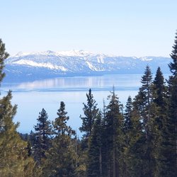
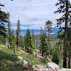
Hiking difficulty level? Easy. Natural beauty factor? Off the charts! This has been one of my favorite trails for years for running whenever I'm in South Lake Tahoe. It's also great for walking and taking in beautiful views of the meadow, trees, mountains, and occassional chipmunk! A lot of locals walk their dogs here (so it's good to be mindful of where you step at times!), and it's obvious our furry friends love this trail as much as us humans! A small parking lot with restrooms is located right on Kahle Rd at the official trailhead. The main trail leads to the Nevada Beach Campgrounds, but you can walk right through to the beach for a little "halftime" break on the shores of beautiful Lake Tahoe before heading back! I've taken so many photos here in pretty much every season, so you can check out a few I posted if you're wondering what the trail looks like in the winter, fall, summer, or spring. Enjoy! :)

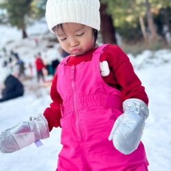
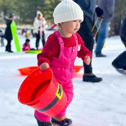
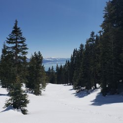
I was a little nervous following a path in the snow because normally there is a concrete path to follow so I wasn't positive I was going to be able to find my way. Luckily the path is so frequently walked by the neighborhood people that there is clear marks in the snow for the entire path. My only disappointment is that in the snow every 10 feet or so there was dog poop on the side of the path in the snow. It made the whole experience feel a little less magical and a little more gross. All I ask is that if you are planning on bringing your dog, please pick up after them! It really does effect everyone else's time! Overall gorgeous walk over two bridges and beautiful quiet stroll in the snow!

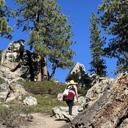
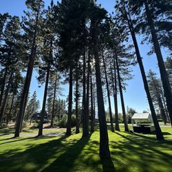
Came up to South Lake Tahoe for R&R and to take in the beauty of the area. Hiking was our agenda to enjoy the scenery and vistas. So we checked out Rabe Meadows - Lam Watah Park. It's located across Stateline on Kahle Road off Hwy 50. There's a small parking lot and a restroom room at the trailhead. The area has a lot of history. The Washoe used it as a summer encampment. The area was logged then, used as cattle grazing land by the Rabe Family before it was sold to a developer that was planning to build a casino here. After the foundation was laid, the land was bought by the US Forest Service who immediately began a restoration of the land. The trail leads you pass a large pond, then onto a boardwalk before you reach a large open meadow. This meadow was the old Sky Harbor Airport and Casino, which served as Lake Tahoe's Airport from the late 1940's until the early 1950's. The trail leads you past he Nevada Beach Campgrounds and then onto Nevada Beach and the shores of Lake Tahoe. This is a scenic easy trail that's about 3 miles roundtrip with paved, dirt and gravel paths that's enjoyed by walkers, bicyclists, runners and dog walkers. A beautiful park in check out while in South Lake Tahoe.

I went on this road trail years ago. It's not quite what I remember it as. I think it's a GREAT walking and running area. There are different dirt paths you can take to make your walk/run longer which is wonderful. I got in close to 5 miles running around this area (could have easily done more). The part that changed was past the Nevada beach the road trail used to go all the way up to Highway 50. You could literally go to the road and back. It was past that other beach that you could just keep going. Well they got rid of that path. So now the road just takes you to the other second beach itself. There is no more upper path which is a bummer because it really extended the walk/run. It was a great for hill workout as well. They were doing construction around that area so hopefully they will bring it back some day. The second bad thing was there were electric bikes & scooters ridden by people on this path. Clearly there are signs that say no electric scooters/bikes. Yet people still do it anyways. I wish those idiots would obey the rules. I just don't like it when the scooters and bikes come flying from behind me or in front of me. Last time when I came there were none of that around. It was nice. Otherwise, the road path does take you to wonderful beach areas. Lots of different nature things along the way. I saw a nice pound, bridge and tree with ordainments. There are bathrooms and drinking fountains at the beach as well. This is a good area as well for dogs. Dogs aren't allowed on the beach itself though. They are allowed on just the walking paths.

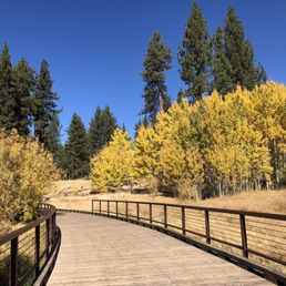
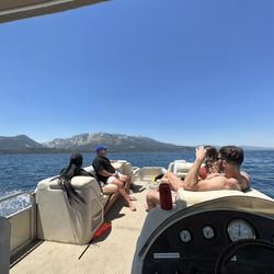
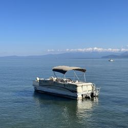
Lam Watah Park is a pretty good size, beautiful CITY park, which has a small charming pond, and trails around and through vast meadows, small wooded hills with big rock boulders; a large campground and a public beach! It's a wonderful park for hiking, running, walking dogs, biking, and swimming! It's very popular for locals and tourists alike. The official trailhead is located off HWY 50 on Kahle Road on the NV side. There's FREE parking by the trailhead across the residential area. The trailhead sign gives an interesting description and history of the park. A few yards away from the trailhead is a small, charming pond with nice, zig-zag shaped wood fences (- see pic). Not far beyond the pond is a small, pretty bridge over a large meadow with tall grass. In Spring and Summer, there is a running stream below the bridge and gorgeous wild flowers in the meadow. Along the trails are many interpretive boards with interesting and educational info on the park. The easy, flat trails, about 2.5 miles round trip to/from the beach, consist of paved path, gravel, boardwalk, and dirt paths - great for walking, hiking, running, biking, as well as for walking dogs! One of the main trails lead to the large RV campground by the lake. This campground is well shaded by tall trees and has shower/toilet facilities. The park and the beach are free, but a fee and advanced reservations are required for the campground. If you hike around on all the side trails, you can easily squeeze in 4mi. The small public Nevada Beach is beautiful and quite popular. The close up view of the lake is spectacular. It's beautiful to see people parasailing kayaking, paddle-boarding in Lake Tahoe or relaxing on the beach! Go enjoy this gorgeous park! ADDITIONAL NOTES A BIT OF HISTORY This land was the home of Washoes, and had the long history of logging, pony express, cattle raising, etc. Once it even had an airport, the "Sky Harbor"! Imagine that! But, it was closed after only a few years of operation, due to frequent, heavy wind, and steep, difficult landing. Once 2 casinos were also planned on this land, but they were never built. The vast land of the park was purchased some hundred yrs ago by Mr. Rabe, whose lumber company exhausted the forest in 7 yrs! It'd take another 100+yrs before the woodland came back to life again. The Rabe meadow now bears his name. US Forest Service bought the land in 1980's and had it restored to the natural state, now as a public park. Go enjoy this gorgeous park! JULY 2015 ---


Nice trail that leads to a large lovely beach with magnificent views of snow capped mountains. Nice clean bathrooms but no cafe or place that sells drinks so bring your own. There is a large covered canopy that appears to be rentable and some other picnic tables and grills. I like this location especially if you are staying in South Shore it's a 5 minute drive.

5 months ago
I just found out about Lam Watah Trail (in South Lake Tahoe/Stateline in the Nevada side) and walked it recently. The name in Washoe means permanent mortar by the stream. The trailhead is right within walking distance from the casinos and Stateline/Highway 50. If walking the strip/Stateline is not your thing, don't forget about the free Lake Link shuttle service. The trail leads to Nevada Beach. It's 2.8 miles roundtrip. Flat, no inclines. My kind of walk. Portions of the trail are packed dirt or paved with the majority of it paved. The trailhead has a small paved parking lot, it's free with no time limits but no overnight parking allowed. There are public restrooms. If they're open, I suggest using those because in the winter all the other restrooms on the trail and the beach are closed. We discovered that the hard way. There are two options of trails at the trailhead parking lot. You can use the paved path or the dirt path. The dirt path provides a view of Jennings pond and field as it is right next to it. Even though the pond itself is about 4 feet, you or your fur babies don't want to fall into that ice cold water so stay on the path. The field and pond tend to blend together in the winter scenery. The paved path doesn't provide views of the meadow or pond. Both trails link together. At this intersection, there is a foot bridge that crosses the Burke Creek. Even in the middle of winter, the creek had a trickling flow of water. The sound was relaxing and serene. The path from this point on is paved. Right now, sections of the path have ice and snow even on a warm sunny winter day. So be prepared with the right footgear. Along the way, there are info boards describing the history. I found out that the indigenous Washoe lived in the area before European settlers, and Rabe meadow served as the Sky Harbor casino and air landing strip in the 1940s. Crazy to think there was a casino and air strip here. On the opposite side of the meadow are large, beautiful granite boulder clusters viewable from the path. And Aspen grooves which I imagine are flaming gorgeous in the Fall. The trail leads to the beach. The beach has a walking path made of a composite grooved decking about 3-4 feet wide. The beach can also be reached by driving to it; it has a paved parking lot and street parking. On the weekday I walked the trail, it had a good number of folks and dogs. Leashed dogs are allowed on the trail but not allowed on the beach. read more


Short walk from Stateline also accessible via free Lake Link shuttle service is this flat level path that goes to the beach also connects to other trails. Bikes and pedestrians. Lot of dogs some not leashed. Lots of fowl wildlife and waters along the way. read more

This trail is a nature lovers dream. So many birds and trees, fresh air, with the lake at the end of the trail. It's usually lot too crowded, but there are lots of dog walkers. Bring your binoculars to enjoy the many species of birds around. This trail has a nice parking lot and restroom at the entrance. If you don't have a car, you can walk from the casino areas pretty easily or take lake link. read more


8/25/2023 After yesterday's hike, this walk is completely my type.. Easy to get here and signs all around.. Level ground, friendly people on the paths.. Disappointing and assumed that irresponsible dog owner's do not pick up..( scattered around the trail).. At the beginning of the trail it stated no dogs and no dogs on beach.. (would of brought mine on next trip).. but I would adhere to the signs .. Minus one star for not keeping the policy in place.. Glad the son persisted on finding another hike and for us to venture out.. read more


6 years ago
Hiking difficulty level? Easy. Natural beauty factor? Off the charts! This has been one of my favorite trails for years for running whenever I'm in South Lake Tahoe. It's also great for walking and taking in beautiful views of the meadow, trees, mountains, and occassional chipmunk! A lot of locals walk their dogs here (so it's good to be mindful of where you step at times!), and it's obvious our furry friends love this trail as much as us humans! A small parking lot with restrooms is located right on Kahle Rd at the official trailhead. The main trail leads to the Nevada Beach Campgrounds, but you can walk right through to the beach for a little "halftime" break on the shores of beautiful Lake Tahoe before heading back! I've taken so many photos here in pretty much every season, so you can check out a few I posted if you're wondering what the trail looks like in the winter, fall, summer, or spring. Enjoy! :) read more
 - Hiking Near Me")
 - Hiking Near Me")
 - Hiking Near Me")

 - Hiking Near Me")
I was a little nervous following a path in the snow because normally there is a concrete path to follow so I wasn't positive I was going to be able to find my way. Luckily the path is so frequently walked by the neighborhood people that there is clear marks in the snow for the entire path. My only disappointment is that in the snow every 10 feet or so there was dog poop on the side of the path in the snow. It made the whole experience feel a little less magical and a little more gross. All I ask is that if you are planning on bringing your dog, please pick up after them! It really does effect everyone else's time! Overall gorgeous walk over two bridges and beautiful quiet stroll in the snow! read more


Came up to South Lake Tahoe for R&R and to take in the beauty of the area. Hiking was our agenda to enjoy the scenery and vistas. So we checked out Rabe Meadows - Lam Watah Park. It's located across Stateline on Kahle Road off Hwy 50. There's a small parking lot and a restroom room at the trailhead. The area has a lot of history. The Washoe used it as a summer encampment. The area was logged then, used as cattle grazing land by the Rabe Family before it was sold to a developer that was planning to build a casino here. After the foundation was laid, the land was bought by the US Forest Service who immediately began a restoration of the land. The trail leads you pass a large pond, then onto a boardwalk before you reach a large open meadow. This meadow was the old Sky Harbor Airport and Casino, which served as Lake Tahoe's Airport from the late 1940's until the early 1950's. The trail leads you past he Nevada Beach Campgrounds and then onto Nevada Beach and the shores of Lake Tahoe. This is a scenic easy trail that's about 3 miles roundtrip with paved, dirt and gravel paths that's enjoyed by walkers, bicyclists, runners and dog walkers. A beautiful park in check out while in South Lake Tahoe. read more


4 years ago
I went on this road trail years ago. It's not quite what I remember it as. I think it's a GREAT walking and running area. There are different dirt paths you can take to make your walk/run longer which is wonderful. I got in close to 5 miles running around this area (could have easily done more). The part that changed was past the Nevada beach the road trail used to go all the way up to Highway 50. You could literally go to the road and back. It was past that other beach that you could just keep going. Well they got rid of that path. So now the road just takes you to the other second beach itself. There is no more upper path which is a bummer because it really extended the walk/run. It was a great for hill workout as well. They were doing construction around that area so hopefully they will bring it back some day. The second bad thing was there were electric bikes & scooters ridden by people on this path. Clearly there are signs that say no electric scooters/bikes. Yet people still do it anyways. I wish those idiots would obey the rules. I just don't like it when the scooters and bikes come flying from behind me or in front of me. Last time when I came there were none of that around. It was nice. Otherwise, the road path does take you to wonderful beach areas. Lots of different nature things along the way. I saw a nice pound, bridge and tree with ordainments. There are bathrooms and drinking fountains at the beach as well. This is a good area as well for dogs. Dogs aren't allowed on the beach itself though. They are allowed on just the walking paths. read more


Lam Watah Park is a pretty good size, beautiful CITY park, which has a small charming pond, and trails around and through vast meadows, small wooded hills with big rock boulders; a large campground and a public beach! It's a wonderful park for hiking, running, walking dogs, biking, and swimming! It's very popular for locals and tourists alike. The official trailhead is located off HWY 50 on Kahle Road on the NV side. There's FREE parking by the trailhead across the residential area. The trailhead sign gives an interesting description and history of the park. A few yards away from the trailhead is a small, charming pond with nice, zig-zag shaped wood fences (- see pic). Not far beyond the pond is a small, pretty bridge over a large meadow with tall grass. In Spring and Summer, there is a running stream below the bridge and gorgeous wild flowers in the meadow. Along the trails are many interpretive boards with interesting and educational info on the park. The easy, flat trails, about 2.5 miles round trip to/from the beach, consist of paved path, gravel, boardwalk, and dirt paths - great for walking, hiking, running, biking, as well as for walking dogs! One of the main trails lead to the large RV campground by the lake. This campground is well shaded by tall trees and has shower/toilet facilities. The park and the beach are free, but a fee and advanced reservations are required for the campground. If you hike around on all the side trails, you can easily squeeze in 4mi. The small public Nevada Beach is beautiful and quite popular. The close up view of the lake is spectacular. It's beautiful to see people parasailing kayaking, paddle-boarding in Lake Tahoe or relaxing on the beach! Go enjoy this gorgeous park! ADDITIONAL NOTES A BIT OF HISTORY This land was the home of Washoes, and had the long history of logging, pony express, cattle raising, etc. Once it even had an airport, the "Sky Harbor"! Imagine that! But, it was closed after only a few years of operation, due to frequent, heavy wind, and steep, difficult landing. Once 2 casinos were also planned on this land, but they were never built. The vast land of the park was purchased some hundred yrs ago by Mr. Rabe, whose lumber company exhausted the forest in 7 yrs! It'd take another 100+yrs before the woodland came back to life again. The Rabe meadow now bears his name. US Forest Service bought the land in 1980's and had it restored to the natural state, now as a public park. Go enjoy this gorgeous park! JULY 2015 --- read more


5 years ago
Easy hike, dog friendly. Had some small streams with fishes in it. Leads out to Lake Tahoe which was gorgeous. If your looking for some thing that had just a little incline for a relaxing hike with a view in Tahoe, put this on your list! read more


Nice trail that leads to a large lovely beach with magnificent views of snow capped mountains. Nice clean bathrooms but no cafe or place that sells drinks so bring your own. There is a large covered canopy that appears to be rentable and some other picnic tables and grills. I like this location especially if you are staying in South Shore it's a 5 minute drive. read more


4 years ago


5 years ago
8 years ago
I found this trail on google maps so decided to check it out. It is 100% concrete road path. I walked from Harrah's hotel all the way down to the Nevada beach. Then walked back to the hotel. That was about over an hour's walk. Later on, I went for my run. First I walked from the Harrah's hotel to the parking lot on Kahle. From that parking lot I ran all the way to highway 50 which is the end of the path. Round trip 4 miles. So 2 miles there and 2 miles back. It was a very nice running flat path. There is also no motor scooters on the path which is nice (because most of those people go fast past you). Bikers are there but usually go slow. I stayed to the side of the path in case any bikers wanted to pass me they could. Not too much wildlife here,but I saw a few chipmunks along the way. (Those little critters are fast!) Highly recommend this path either for biking, running or walking. It's probably best to go running/walking mid or early morning as it's hot. The path tends to be in the sun in the beginning and more shade as you get get into mile 2. There is also a nice water fountain at the Nevada Beach if you need some and also at the parking lot off Kahle near the bathrooms. Highly recommend using this path. read more

8 years ago
More info about Lam Watah Trail to NV Beach
Stateline, NV 89449
Directions
Hours
Indoor Amenities
Outdoor Amenities
Ask the Community - Lam Watah Trail to NV Beach
Review Highlights - Lam Watah Trail to NV Beach
You might also consider


Lam Watah Trail to NV Beach - hiking - Updated July 2026
Best of Stateline
People found Lam Watah Trail to NV Beach by searching for…
Free Parking in Stateline, Nevada
Free Snow Play in Stateline, Nevada
Public Shower in Stateline, Nevada
Hiking Trails in Stateline, Nevada
Campgrounds in Stateline, Nevada
Fun Things to Do in Stateline, Nevada
Walking Trails in Stateline, Nevada
Dog Friendly Beaches in Stateline, Nevada
Scenic View in Stateline, Nevada
Things to Do With Kids in Stateline, Nevada
Boardwalk in Stateline, Nevada
Dog Friendly Trails in Stateline, Nevada
Easy Hikes in Stateline, Nevada
Running Trails in Stateline, Nevada
Parks for Kids in Stateline, Nevada
Picnic Spots in Stateline, Nevada
Free Campgrounds in Stateline, Nevada
Lakes & Ponds in Stateline, Nevada
Trending Searches in Stateline, NV
Cliff Jumping in Stateline, NV
Dog Friendly Trails in Stateline, NV
Jet Ski Rental in Stateline, NV
Lakes & Ponds in Stateline, NV
Outdoor Activities in Stateline, NV
Public Shower in Stateline, NV
River Swimming in Stateline, NV
Running Trails in Stateline, NV
Scenic Overlook in Stateline, NV
Secluded Spots in Stateline, NV
Strawberry Picking in Stateline, NV
Swimming Holes in Stateline, NV
Swimming Lakes in Stateline, NV
Browse Articles
Browse Nearby
BEST of Stateline, Nevada Coffee near Lam Watah Trail to NV Beach
BEST of Stateline, Nevada Restaurants near Lam Watah Trail to NV Beach
BEST of Stateline, Nevada Things to Do near Lam Watah Trail to NV Beach
BEST of Stateline, Nevada Walking Trails near Lam Watah Trail to NV Beach
BEST of Stateline, Nevada Parks near Lam Watah Trail to NV Beach
BEST of Stateline, Nevada Breakfast near Lam Watah Trail to NV Beach
BEST of Stateline, Nevada Campgrounds near Lam Watah Trail to NV Beach
BEST of Stateline, Nevada Hot Springs near Lam Watah Trail to NV Beach
BEST of Stateline, Nevada Sightseeing near Lam Watah Trail to NV Beach
Browse Brands
Related Searches in Stateline, NV
Affordable Kayak Rental Services in Stateline, Nevada
Best Fishing Locations and Guides in Stateline, Nevada
Best Places for Horseback Riding in Stateline, Nevada
Best Sledding Spots and Fun in Stateline, Nevada
Best Spots for Star Gazing in Stateline, Nevada
Check Out Off Road Trails in Stateline, Nevada
Discover Dog Friendly Trails to Explore in Stateline, Nevada
Discover Kid Friendly Hiking Trails in Stateline, Nevada
Discover Scenic Waterfall Spots in Stateline, Nevada
Discover Top Boat Tours in Stateline, Nevada for All Ages
Discover Top State Parks to Visit in Stateline, Nevada
Discover a Hiking Trail in Stateline, Nevada
Discover the Best Night Hike Trails in Stateline, Nevada
Dog-Friendly Hikes With Dogs in Stateline, Nevada
Enjoy Camping Adventures Around Stateline, Nevada
Enjoy Kayaking Adventures in Stateline, Nevada
Enjoy Tent Camping Spots Around Stateline, Nevada
Enjoy Water Activities and Fun in Stateline, Nevada
Enjoy a Beautiful Waterfall Hike in Stateline, Nevada
Enjoy the Best Tubing Experiences in Stateline, Nevada
Enjoy the Best Walking Path in Stateline, Nevada
Enjoy the Best Walking Trails in Stateline, Nevada
Experience Thrilling White Water Rafting in Stateline, Nevada
Explore Beautiful Parks and Green Spaces in Stateline, Nevada
Explore Easy Hikes Perfect for All in Stateline, Nevada
Explore Fun Activities to Do in Stateline, Nevada
Explore Popular Campgrounds Near Stateline, Nevada
Explore Popular Scenic Overlook Points in Stateline, Nevada
Explore Popular View Points Around Stateline, Nevada
Explore Scenic Lakes to Visit in Stateline, Nevada
Explore Top Dog Parks in Stateline, Nevada Near You
Explore the Best Beach Spots in Stateline, Nevada
Explore the Best Boating Spots in Stateline, Nevada
Explore the Best Trail Options in Stateline, Nevada
Family Friendly Hiking With Kids in Stateline, Nevada
Find Popular Ziplining Spots Around Stateline, Nevada
Find the Best Scenic View Locations in Stateline, Nevada
Great Places to Walk in Stateline, Nevada
Hiking Trails With Waterfalls in Stateline, Nevada
Off Leash Dog Hiking Trails in Stateline, Nevada
Plan a Scenic Drive Route Near Stateline, Nevada
Popular Outdoor Activities to Try in Stateline, Nevada
Safe and Fun Parks for Kids in Stateline, Nevada
Top Climbing Spots and Gyms in Stateline, Nevada
Top Paddleboarding Activities in Stateline, Nevada
Top Places for Snorkeling in Stateline, Nevada
Top Running Trails to Explore in Stateline, Nevada
Top Swimming Lakes to Enjoy in Stateline, Nevada
People who viewed Lam Watah Trail to NV Beach also viewed
Cascade Falls
41 reviews
Eagle Falls Trailhead
209 reviews
Van Sickle Bi-State Park
88 reviews
Cave Rock Trail Head Glenbrook NV
13 reviews
High Meadow Trailhead
3 reviews
Tahoe Rim Trail
18 reviews
Washoe Meadows State Park
1 review
Fallen Leaf Lake
108 reviews
Rubicon Peak Trail
2 reviews
Round Hill Pines Trail
2 reviews