Mount Timpanogos Wilderness Area Photos


You might also consider
More like Mount Timpanogos Wilderness Area
Recommended Reviews - Mount Timpanogos Wilderness Area
Start your review...

Reviews With Photos

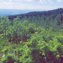
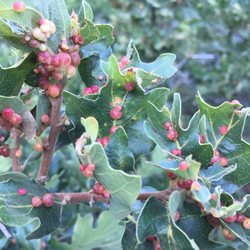
This area has so many beautiful sites and trails! We discovered lots of beauty everywhere we went. There are also easy hikes available for scenic pictures. In the spring and summer, you can find many poppy groves that are breathtaking. There are lots of wild animals as well. We saw a handful of rattlesnakes in the region so be careful with kids!

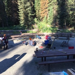
O.M.G. This place is gorgeous: a blend of Aspen and deciduous woods, it's a place that will be gorgeous any time of year. The pine forest is in fairly good shape, with what appeared to be little pine beetle damage or over-logging. Since this is a wilderness area, you can bivy out and camp in the wilderness areas (there's one up near the summit pass) or you can pay your campsite fee and camp at the primitive sites that come with concrete pits for campfires and concrete pads. IMPORTANT NOTE: The sites listed online are not clearly indicated that they are DOUBLE sites. That means, UNLESS you reserve BOTH sites, you could be camping neck-to-neck with someone you don't know. So book both sites and pay the extra dough. The best by far is the site that's near the trailhead for the Mount Timpanogos trail and parking lot. There's two sites there 4 and 5. 4 is butted up against a thick Aspen site. 5 is better and is SIMPLY one of the most amazing sites I've ever seen. Covered with old enormous pines, it bellies up to the rapids below which during early summer are very swollen and wild. The sound permeates everything, everywhere you go. The bad thing is that it's so loud, a bear will not hear you, so hike/bike with bear bells. The good thing is that when you're trying to sleep, it's heaven. Another note: it gets cold as hell here, especially the higher you go. So even in summer, pack your -0 sleeping bag and polypropylene, though in the day, it can get hot. I would NOT recommend the lower mountain sites, as they became severely flooded while we were at the higher elevation, and campers had to be evacuated. With all the heavy snow pack, lots of rain, those sites flood, as does the road, which, after two nights of camping, we frightfully discovered. So keep an eye on where the park rangers and camp hosts are to get updates on if the roads are still open in case of rain. This is back country at its best. To hike to the Timpanagos Trail, you will cross soggy snowfields and have creek crossings. It's rather rugged, but you CAN hike for a little ways, then always turn back if you're creeped out. Another thing to note: the mosquitoes here (because of all the run-off) are bad. Another notable: it is a LONG, winding drive with no guardrails, so be careful of other drivers and make sure you get enough beer/ice to last you as the drive to Provo is a long one and there's no concessionaires on the mountain to sell either beer or gas. But the views, despite the bear warnings, floods and mosquitoes are worth the long drive. You've got to watch out for bears though we didn't see any.


An absolutely beautiful area with a gorgeous and LONG hike to the Mount Timpanogos summit. We camped in the official Timpanooke campground so that we could start our hike around 3am from the trailhead. 12 long hours later we arrived back to where we started, but we did it! There were deer, smaller wildlife, and mountain goats. We did not feel threatened by other wildlife. read more


I was able to do an overnight Timp hike. It's 15 mile round trip, with a 35lb pack. Here are some of the amazing pictures and videos if you haven't been up there. The weather was calm and hot and the night was vibrant. They now have cell service at the top and along most of the trail, which gives a sense of safety. There were hundreds of people hiking the entire night long. I camped in the meadows area. read more


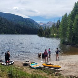
We were extremely surprised to find a camping spot up American Fork Canyon in Tibble Fork at the first come, first serve camp grounds. Mind you, this was on Memorial Day weekend on that Sunday!! A total of maybe 40mins drive from Lehi. We were lucky enough to find a spot only about 10-15mins past Tibble Fork reservoir. We were right on the river and were able to bring the dogs and build a fire. We were able to park two trucks pretty easily on the side of the dirt road coming in. The surrounding camps were relatively quiet and far enough for us to feel comfortable to play our music. Whoever was at our campsite last kinda trashed the place with some soda cans and (the worst part), their used toilet paper was thrown around in the bushes. Just be a cool person, and please don't be like that. Leave it the way nature intended. Por favor. read more


7 years ago
This area has so many beautiful sites and trails! We discovered lots of beauty everywhere we went. There are also easy hikes available for scenic pictures. In the spring and summer, you can find many poppy groves that are breathtaking. There are lots of wild animals as well. We saw a handful of rattlesnakes in the region so be careful with kids! read more


9 years ago
15 years ago
O.M.G. This place is gorgeous: a blend of Aspen and deciduous woods, it's a place that will be gorgeous any time of year. The pine forest is in fairly good shape, with what appeared to be little pine beetle damage or over-logging. Since this is a wilderness area, you can bivy out and camp in the wilderness areas (there's one up near the summit pass) or you can pay your campsite fee and camp at the primitive sites that come with concrete pits for campfires and concrete pads. IMPORTANT NOTE: The sites listed online are not clearly indicated that they are DOUBLE sites. That means, UNLESS you reserve BOTH sites, you could be camping neck-to-neck with someone you don't know. So book both sites and pay the extra dough. The best by far is the site that's near the trailhead for the Mount Timpanogos trail and parking lot. There's two sites there 4 and 5. 4 is butted up against a thick Aspen site. 5 is better and is SIMPLY one of the most amazing sites I've ever seen. Covered with old enormous pines, it bellies up to the rapids below which during early summer are very swollen and wild. The sound permeates everything, everywhere you go. The bad thing is that it's so loud, a bear will not hear you, so hike/bike with bear bells. The good thing is that when you're trying to sleep, it's heaven. Another note: it gets cold as hell here, especially the higher you go. So even in summer, pack your -0 sleeping bag and polypropylene, though in the day, it can get hot. I would NOT recommend the lower mountain sites, as they became severely flooded while we were at the higher elevation, and campers had to be evacuated. With all the heavy snow pack, lots of rain, those sites flood, as does the road, which, after two nights of camping, we frightfully discovered. So keep an eye on where the park rangers and camp hosts are to get updates on if the roads are still open in case of rain. This is back country at its best. To hike to the Timpanagos Trail, you will cross soggy snowfields and have creek crossings. It's rather rugged, but you CAN hike for a little ways, then always turn back if you're creeped out. Another thing to note: the mosquitoes here (because of all the run-off) are bad. Another notable: it is a LONG, winding drive with no guardrails, so be careful of other drivers and make sure you get enough beer/ice to last you as the drive to Provo is a long one and there's no concessionaires on the mountain to sell either beer or gas. But the views, despite the bear warnings, floods and mosquitoes are worth the long drive. You've got to watch out for bears though we didn't see any. read more


7 years ago
Just absolutely beautiful. Utah has some of the best outdoor scenery. All of the uinta moutains and Mt timpanigos is a must see if your visiting for Utah. Hike up to the caves, head to timblefork lake, or just around the alpine loop. It's all worth your time. read more


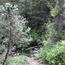
It took me all week to finally pronounce this place correctly, tim-pe-no-ges. This place is amazing. Located in American Fork, UT inside the Uinta National Forest. Filled with pine, quaking aspen, maple and a plethora of other trees, it was like a postcard come to life. I couldn't stop saying "OMG this is so beautiful". Was able to hike a few trails, starting with Stewarts Cascades which begins at the Aspen Grove entrance of the park and is a 3-4 mile round trip moderate trail with a gorgeous couple of waterfalls at the end. Also the Tibble Fork Trail which started at the east end of the Tibble Fork Reservoir dam which was supposed to be about 5 miles roundtrip but we didn't pay attention and this trail actually runs into the Ridge Trail, this was a moderately steep trail that offered a great cardo workout with phenomenal views of the Wasatch Mtn range, thick groves of aspen trees and a plateau we were hoping to catch some elk roaming around. I'm so glad I was able to get up here during this time of year when all the leaves were changing color, I don't want to sound corny but it was truly breath taking. There are so many things to do here, they have theater-in-the-pines, which is basically an outdoor stage, ride a bike or horseback, volunteer, camp, climb, and of course the Timpanogos Cave. Maybe someday I will return to hike to the summit of Mount Timp. We'll see. Entrance fee to the canyon ranges from $6 for a 3 day pass, to $45 for and annual pass, or if you have a America the Beautiful pass, formerly known as Golden Eagle, this will get you in for free. read more


13 years ago
12 years ago
10 years ago
9 years ago
More info about Mount Timpanogos Wilderness Area
American Fork, UT 84003
Directions
(801) 756-5238
Call Now
Visit Website
http://www.nps.gov/tica
Hours
Outdoor Amenities
Other Amenities
Ask the Community - Mount Timpanogos Wilderness Area
Review Highlights - Mount Timpanogos Wilderness Area
You might also consider


Why does Yelp recommend reviews?
Mount Timpanogos Wilderness Area - campgrounds - Updated June 2026
Best of American Fork
People found Mount Timpanogos Wilderness Area by searching for…
Places to Take Pictures in American Fork, Utah
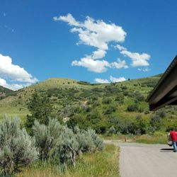
Scenic Drive in American Fork, Utah
Swimming Holes in American Fork, Utah
Hiking Trails With Waterfalls in American Fork, Utah
Things to Do in American Fork, Utah
Beautiful Views in American Fork, Utah
Sunrise View in American Fork, Utah
Picnic Areas in American Fork, Utah
Scenic View in American Fork, Utah
Easy Hikes in American Fork, Utah
Indoor Rock Climbing in American Fork, Utah
Off Road Trails in American Fork, Utah
Bonfire in American Fork, Utah
Watch Sunset in American Fork, Utah
Make Out Spot in American Fork, Utah
Night View in American Fork, Utah
Hiking With Kids in American Fork, Utah
Running Trails in American Fork, Utah
Secret Spots in American Fork, Utah
Sunset View in American Fork, Utah
Trending Searches in American Fork, UT
Amusement Parks near Mount Timpanogos Wilderness Area
Beaches near Mount Timpanogos Wilderness Area
Boat Rental near Mount Timpanogos Wilderness Area
Cabins near Mount Timpanogos Wilderness Area
Campgrounds near Mount Timpanogos Wilderness Area
Cliff Jumping near Mount Timpanogos Wilderness Area
Day Trips near Mount Timpanogos Wilderness Area
Dog Friendly Things To Do near Mount Timpanogos Wilderness Area
Free Kids Activities near Mount Timpanogos Wilderness Area
Jet Ski Rental near Mount Timpanogos Wilderness Area
Lakes near Mount Timpanogos Wilderness Area
Outdoor Activities near Mount Timpanogos Wilderness Area
Picnic Areas near Mount Timpanogos Wilderness Area
Public Pools near Mount Timpanogos Wilderness Area
Public Shower near Mount Timpanogos Wilderness Area
River Swimming near Mount Timpanogos Wilderness Area
Rock Quarry near Mount Timpanogos Wilderness Area
Running Trails near Mount Timpanogos Wilderness Area
Rv Parks near Mount Timpanogos Wilderness Area
Scenic Drive near Mount Timpanogos Wilderness Area
Secluded Spots near Mount Timpanogos Wilderness Area
Secret Spots near Mount Timpanogos Wilderness Area
Splash Pad near Mount Timpanogos Wilderness Area
State Parks near Mount Timpanogos Wilderness Area
Strawberry Picking near Mount Timpanogos Wilderness Area
Summer Camps near Mount Timpanogos Wilderness Area
Sunrise View near Mount Timpanogos Wilderness Area
Swimming Holes near Mount Timpanogos Wilderness Area
Swimming Lakes near Mount Timpanogos Wilderness Area
Swimming Pools near Mount Timpanogos Wilderness Area
Watch Sunset near Mount Timpanogos Wilderness Area
Browse Articles
Browse Nearby
BEST of American Fork, Utah Hotels near Mount Timpanogos Wilderness Area
BEST of American Fork, Utah Lakes near Mount Timpanogos Wilderness Area
BEST of American Fork, Utah Restaurants near Mount Timpanogos Wilderness Area
BEST of American Fork, Utah Hiking near Mount Timpanogos Wilderness Area
BEST of American Fork, Utah Lunch near Mount Timpanogos Wilderness Area
Browse Brands
Related Cost Guides
Related Searches in American Fork, UT
Affordable Kayak Rental Services in American Fork, Utah
Affordable Long Term RV Parking in American Fork, Utah
Best Fishing Locations and Guides in American Fork, Utah
Best Gymnastics for Kids Activities in American Fork, Utah
Best Places for Calisthenics Workouts in American Fork, Utah
Best Places for Exercise and Fitness in American Fork, Utah
Best Places for Horseback Riding in American Fork, Utah
Best Summer Camps for Kids Located in American Fork, Utah
Best Waterfalls and Swimming Holes in American Fork, Utah
Browse Charming Cabins in American Fork, Utah
Browse Top Hotels in American Fork, Utah for Your Stay
Challenge Yourself With an Obstacle Course in American Fork, Utah
Check Out Off Road Trails in American Fork, Utah
Discover Dog Friendly Trails to Explore in American Fork, Utah
Discover Exciting Adventure Options in American Fork, Utah
Discover Fun Activities to Do in American Fork, Utah
Discover Lakes & Ponds to Explore in American Fork, Utah
Discover Popular Ropes Course Options in American Fork, Utah
Discover Scenic Beach Camping Sites in American Fork, Utah
Discover Scenic Mountain Bike Trails Near American Fork, Utah
Discover Scenic Waterfall Spots in American Fork, Utah
Discover Top Scenic Spots to Visit in American Fork, Utah
Discover Top State Parks to Visit in American Fork, Utah
Discover Top Yoga Options and Studios in American Fork, Utah
Discover a Hiking Trail in American Fork, Utah
Discover the Best Beaches in American Fork, Utah
Discover the Best Night Hike Trails in American Fork, Utah
Discover the Best Running Track in American Fork, Utah
Dog-Friendly Hikes With Dogs in American Fork, Utah
Enjoy Camping Adventures Around American Fork, Utah
Enjoy Hiking Adventures in American Fork, Utah
Enjoy Kayaking Adventures in American Fork, Utah
Enjoy RV Camping Adventures in American Fork, Utah
Enjoy River Tubing Adventures in American Fork, Utah
Enjoy Tent Camping Spots Around American Fork, Utah
Enjoy Water Activities and Fun in American Fork, Utah
Enjoy a Beautiful Waterfall Hike in American Fork, Utah
Enjoy the Best Bouldering Experiences in American Fork, Utah
Enjoy the Best Picnic Spots and Ideas in American Fork, Utah
Enjoy the Best Walking Trails in American Fork, Utah
Exciting Cliff Jumping Spots in American Fork, Utah
Experience Aerial Yoga Sessions in American Fork, Utah
Experience Ninja Warrior Challenges in American Fork, Utah
Experience Thrilling White Water Rafting in American Fork, Utah
Explore Beautiful Parks and Green Spaces in American Fork, Utah
Explore Easy Hikes Perfect for All in American Fork, Utah
Explore Exciting Kids Fun Activities in American Fork, Utah
Explore Fitness Centers and Gyms in American Fork, Utah
People who viewed Mount Timpanogos Wilderness Area also viewed
Twin Lakes Pass
3 reviews
Silver Lake
36 reviews
Mount Olympus Trailhead
10 reviews
Ferguson Canyon
8 reviews
Red Pine Trail
4 reviews
Lisa Falls
3 reviews
Ghost Falls Trail
2 reviews
Willow Heights Trail
6 reviews
Salt Lake Valley Overlook
2 reviews
Olympus Cove
Lower Bells Canyon Reservoir via Granite Trail Head
6 reviews