Rim Crest Trail Photos


You might also consider
More like Rim Crest Trail
Recommended Reviews - Rim Crest Trail
Start your review...

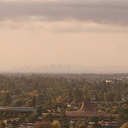
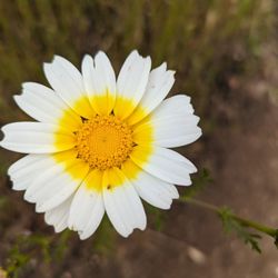
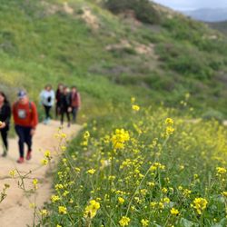
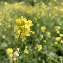
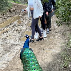
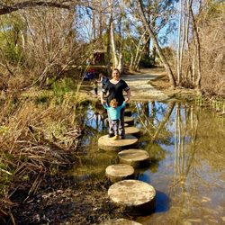
Nice trails near home, part of Chino Hills State Park. There are great views to the south west of Anaheim on the weekend there are groups of hikers and bikers . During the school year you will see high school cross country runners training. read more


1 year ago
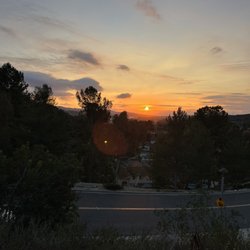
update 7/17 : straight to the point review. There are multiple points of entry. This trail, the quarter horse entry is a moderate to difficult rating for walkers, joggers, runners, and bikers ( no ebikes). I don't recommend this trail if you're a newbie or new to difficult trails. To the west, it'trail gets easy long winding paths which lead to carbon canyon. To the east, its hilly and multiple trails can be found heading deeper into the trail network system. From 1 mile to over 20 miles of trails can be found, many of which will be exciting, tough and challenging. Take water, take snacks, don't liter and be careful with the sun ; as it can get very warm during the summer. there are Great morning sceneries and fantastic sunset views. Bathrooms exist only at the stagging areas. overall, the areas present a quiet simple and affluent neighborhood. Possible horse trails are available, chk website or the city parks page for more information. A rating of 4.0 to 4.25 is given. the only complexity, is that there are no water stations or rest areas where benches can be set. these trails are virtually all the same. as for ridgecrest? none of the signs show that information. instead, telegraph glider san juan rolling ranch Rim Gilman peak read more


More info about Rim Crest Trail
Yorba Linda, CA 92886
Directions
Hours
Outdoor Amenities
You might also consider


Rim Crest Trail - hiking - Updated July 2026
Best of Yorba Linda
People found Rim Crest Trail by searching for…
Hiking Trails in Yorba Linda, California
Beautiful Views in Yorba Linda, California
Things to Do in Yorba Linda, California
Parks in Yorba Linda, California
Walking Trails in Yorba Linda, California
Scenic View in Yorba Linda, California
Running Trails in Yorba Linda, California
Bike Paths in Yorba Linda, California
Trails in Yorba Linda, California
Hiking Groups in Yorba Linda, California
Places to Walk at Night in Yorba Linda, California
State Park in Yorba Linda, California
Shaded Hike in Yorba Linda, California
Views in Yorba Linda, California
Hiking Club in Yorba Linda, California
Places to Walk Around in Yorba Linda, California
Sunset View in Yorba Linda, California
Waterfalls in Yorba Linda, California
Fun Things to Do for a Birthday in Yorba Linda, California
Places to Go in Yorba Linda, California
Scenic Spots in Yorba Linda, California
Photo Spots in Yorba Linda, California
Trending Searches in Yorba Linda, CA
4th Of July Fireworks in Yorba Linda, CA
Black Owned Nail Salons in Yorba Linda, CA
Boat Rental in Yorba Linda, CA
Cliff Jumping in Yorba Linda, CA
Jet Ski Rental in Yorba Linda, CA
Kayak Rental in Yorba Linda, CA
Lakes & Ponds in Yorba Linda, CA
Off Road Trails in Yorba Linda, CA
Outdoor Activities in Yorba Linda, CA
Places To Walk Around in Yorba Linda, CA
Public Pools in Yorba Linda, CA
Public Shower in Yorba Linda, CA
River Swimming in Yorba Linda, CA
Rock Quarry in Yorba Linda, CA
Running Trails in Yorba Linda, CA
Scenic Night View in Yorba Linda, CA
Scenic Overlook in Yorba Linda, CA
Secluded Spots in Yorba Linda, CA
Soccer Store in Yorba Linda, CA
Strawberry Picking in Yorba Linda, CA
Sunrise View in Yorba Linda, CA
Swimming Holes in Yorba Linda, CA
Swimming Lakes in Yorba Linda, CA
Watch Sunset in Yorba Linda, CA
Browse Articles
Browse Nearby
BEST of Yorba Linda, California Coffee near Rim Crest Trail
BEST of Yorba Linda, California Restaurants near Rim Crest Trail
BEST of Yorba Linda, California Things to Do near Rim Crest Trail
BEST of Yorba Linda, California Breakfast near Rim Crest Trail
BEST of Yorba Linda, California Walking Trails near Rim Crest Trail
BEST of Yorba Linda, California Parks near Rim Crest Trail
BEST of Yorba Linda, California Hot Springs near Rim Crest Trail
BEST of Yorba Linda, California Campgrounds near Rim Crest Trail
BEST of Yorba Linda, California Sightseeing near Rim Crest Trail
Browse Brands
Related Searches in Yorba Linda, CA
Affordable Kayak Rental Services in Yorba Linda, California
Best Fishing Locations and Guides in Yorba Linda, California
Best Nature Trails for Hiking in Yorba Linda, California
Best Places for Horseback Riding in Yorba Linda, California
Check Out Off Road Trails in Yorba Linda, California
Discover Dog Friendly Trails to Explore in Yorba Linda, California
Discover Kid Friendly Hiking Trails in Yorba Linda, California
Discover Scenic Hiking Trails in Yorba Linda, California
Discover Scenic Mountain Bike Trails Near Yorba Linda, California
Discover Scenic Waterfall Spots in Yorba Linda, California
Discover Walking Parks in Yorba Linda, California Near You
Discover a Hiking Trail in Yorba Linda, California
Discover the Best Night Hike Trails in Yorba Linda, California
Dog-Friendly Hikes With Dogs in Yorba Linda, California
Enjoy Camping Adventures Around Yorba Linda, California
Enjoy Exciting Mountain Biking Adventures in Yorba Linda, California
Enjoy Kayaking Adventures in Yorba Linda, California
Enjoy Tent Camping Spots Around Yorba Linda, California
Enjoy a Beautiful Waterfall Hike in Yorba Linda, California
Enjoy a Peaceful Nature Walk in Yorba Linda, California
Enjoy the Best Walking Path in Yorba Linda, California
Enjoy the Best Walking Trails in Yorba Linda, California
Exciting Cliff Jumping Spots in Yorba Linda, California
Explore Beautiful Parks and Green Spaces in Yorba Linda, California
Explore Easy Hikes Perfect for All in Yorba Linda, California
Explore Fun Activities to Do in Yorba Linda, California
Explore Popular Campgrounds Near Yorba Linda, California
Explore the Best Beach Spots in Yorba Linda, California
Explore the Best Swimming Holes Around Yorba Linda, California
Explore the Best Trail Options in Yorba Linda, California
Family Friendly Hiking With Kids in Yorba Linda, California
Find Beautiful Views in Yorba Linda, California
Find the Best Parks for Picnics in Yorba Linda, California
Find the Best Scenic View Locations in Yorba Linda, California
Great Places to Walk in Yorba Linda, California
Hike the Popular Waterfall Trail in Yorba Linda, California
Hiking Trails With Waterfalls in Yorba Linda, California
Off Leash Dog Hiking Trails in Yorba Linda, California
Plan a Scenic Drive Route Near Yorba Linda, California
Popular Outdoor Activities to Try in Yorba Linda, California
Popular Picnic Spots to Visit in Yorba Linda, California
Safe River Swimming Areas in Yorba Linda, California
Safe and Fun Parks for Kids in Yorba Linda, California
Top Climbing Spots and Gyms in Yorba Linda, California
Top Paddleboarding Activities in Yorba Linda, California
Top Running Trails to Explore in Yorba Linda, California
Top Swimming Lakes to Enjoy in Yorba Linda, California
Top Swimming Spots and Pools in Yorba Linda, California
Walk Dog Friendly Hiking Trails in Yorba Linda, California
Walk the Best Paved Walking Trails in Yorba Linda, California
People who viewed Rim Crest Trail also viewed
Casino Ridge Staging
1 review
El Cajon Trail
1 review
Deer Canyon Park Preserve
19 reviews
OC Trail Loop El Cajon
1 review
Quarter Horse Staging Area
1 review
Olinda Oil Museum and Trail
32 reviews
Lost Trail
3 reviews
El Cajon Oc Loop Connector
1 review
Chino hills Discovery Center
1 review
Santiago Creek Bike Trail
29 reviews