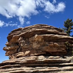
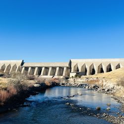
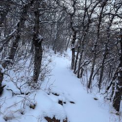
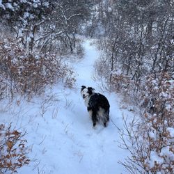
Tunnel Drive Trailhead Photos


You might also consider
More like Tunnel Drive Trailhead
Recommended Reviews - Tunnel Drive Trailhead
Start your review...

Reviews With Photos

Kids slept in at the hotel after camping for 5 days, so I decided to head out for a quick hike right outside of Canon City. This trail starts off with a steep paved trail up to the first of three tunnels. Once past the incline, this trail is a gravel path with minimal elevation. Wish I would have brought my bike to cruise to the end of the trail. Great views of the Arkansas River and railroad below. At the end of the trail, I had my breakfast and enjoyed the solitude. Didn't see any bighorn sheep and the trail up the mountain was closed due to breeding season, but will be back to head to the top next time. Great hike for all levels.

3 months ago


I spent the day in Canon City and was so glad that I decided to check out this trail! I absolutely loved walking it! Only wish I could've spent more time on it. I had to turn around because of an injury to one of my toes. I ended up walking a long distance but could've walked further if it hadn't been for my toe. Make sure that you bring water while walking the trail. Wear sunscreen and a good hat as well. I enjoyed the length of the trail and the view of the river while walking it. It was wonderful seeing fellow trail walkers as well! I love how the trailhead starts out paved and how you must walk a while up a winding incline. This trailhead is also sort of "off the beaten path" as well. I like that aspect of it as well. I'm planning on returning here again to walk more of the trail. I will definitely bring my Camelbak on my next trek. I also recommend wearing hiking shoes on this trail. Once you pass the initial winding incline, which isn't that long, this trail is completely flat. I'm recommending hiking shoes because the trail is dirt and small rocks. If you're ever in Canon City, check out this trail. You will probably like it or perhaps fall in love with it, like I have. Also, there are public restrooms at the bottom of the trailhead and there is plenty of parking nearby. The parking isn't a paved lot or lined spaces. There is just plenty of area to park at. Enjoy your visit here! read more


5 years ago
We were drawn to Cañon City by two big tourist attractions in the area and we ended up enjoying this free trail the most. The trail is about two miles one way and it dead ends, so you will need to walk back the same way. It looks like they are working on building an additional trail up the mountain at the end of the trail. From the trail you can see the Royal Gorge train below. We ended up skipping the train ride after visiting this trail (and saving ourselves almost $500). If you're lucky you will also get to see bighorn sheep hanging out on the mountains. One thing to note, it gets hot here! We went about 10am in early April. The temperature was only in the 60s but with the sun shining and zero shade we quickly got warm. If you're going in the summer be mindful of what time you go. read more


Kids slept in at the hotel after camping for 5 days, so I decided to head out for a quick hike right outside of Canon City. This trail starts off with a steep paved trail up to the first of three tunnels. Once past the incline, this trail is a gravel path with minimal elevation. Wish I would have brought my bike to cruise to the end of the trail. Great views of the Arkansas River and railroad below. At the end of the trail, I had my breakfast and enjoyed the solitude. Didn't see any bighorn sheep and the trail up the mountain was closed due to breeding season, but will be back to head to the top next time. Great hike for all levels. read more


4 years ago
I was not expecting the long walk. We finished half of the walk and the views were beautiful! We are from Chicago and this is definitely worth a stop to walk and move your legs! There is also a bathroom at the beginning of your trail read more

More info about Tunnel Drive Trailhead
205 Tunnel Dr
Cañon City, CO 81212
Directions
Visit Website
https://royalgorgeregion.com
Hours
Outdoor Amenities


Tunnel Drive Trailhead - hiking - Updated June 2026
Best of Cañon City
People found Tunnel Drive Trailhead by searching for…
Things to Do in Cañon City, CO
Secret Spots in Cañon City, CO
Hiking Trails With Waterfalls in Cañon City, CO
Tourist Attractions in Cañon City, CO
Scenic Views in Cañon City, CO
Fun Things to Do at Night in Cañon City, CO
Sunrise View in Cañon City, CO
Beautiful Views in Cañon City, CO
Scenic Overlook in Cañon City, CO
Off Road Trails in Cañon City, CO
Things to Do on a Rainy Day in Cañon City, CO
Romantic Views in Cañon City, CO
Redwood Trees in Cañon City, CO
Running Trails in Cañon City, CO
Trending Searches in Cañon City, CO
Amusement Parks near Tunnel Drive Trailhead
Beaches near Tunnel Drive Trailhead
Boat Rental near Tunnel Drive Trailhead
Cliff Jumping near Tunnel Drive Trailhead
Fruit Picking near Tunnel Drive Trailhead
Kayak Rental near Tunnel Drive Trailhead
Lakes near Tunnel Drive Trailhead
Pick Your Own Farms near Tunnel Drive Trailhead
Public Shower near Tunnel Drive Trailhead
River Swimming near Tunnel Drive Trailhead
Scenic Drive near Tunnel Drive Trailhead
Splash Pad near Tunnel Drive Trailhead
Strawberry Picking near Tunnel Drive Trailhead
Swimming Holes near Tunnel Drive Trailhead
Swimming Pools near Tunnel Drive Trailhead
Watch Sunset near Tunnel Drive Trailhead
Browse Articles
Browse Nearby
BEST of Cañon City, Colorado Restaurants near Tunnel Drive Trailhead
BEST of Cañon City, Colorado Things to Do near Tunnel Drive Trailhead
BEST of Cañon City, Colorado Coffee near Tunnel Drive Trailhead
BEST of Cañon City, Colorado Breakfast near Tunnel Drive Trailhead
BEST of Cañon City, Colorado Horseback Riding near Tunnel Drive Trailhead
Browse Brands
Related Searches in Cañon City, CO
Affordable Kayak Rental Services in Cañon City, Colorado
Best Fishing Locations and Guides in Cañon City, Colorado
Best Fun Things to Do in Cañon City, Colorado
Best Nature Trails for Hiking in Cañon City, Colorado
Best Places for Horseback Riding in Cañon City, Colorado
Best Spots for Star Gazing in Cañon City, Colorado
Discover Dog Friendly Trails to Explore in Cañon City, Colorado
Discover Popular Photo Spots in Cañon City, Colorado
Discover Top Boat Tours in Cañon City, Colorado for All Ages
Discover a Hiking Trail in Cañon City, Colorado
Discover the Best Night Hike Trails in Cañon City, Colorado
Dog-Friendly Hikes With Dogs in Cañon City, Colorado
Enjoy Camping Adventures Around Cañon City, Colorado
Enjoy Kayaking Adventures in Cañon City, Colorado
Enjoy the Best Tubing Experiences in Cañon City, Colorado
Enjoy the Best Walking Trails in Cañon City, Colorado
Exciting Cliff Jumping Spots in Cañon City, Colorado
Experience Thrilling White Water Rafting in Cañon City, Colorado
Explore Beautiful Parks and Green Spaces in Cañon City, Colorado
Explore Bike Rentals Throughout Cañon City, Colorado
Explore Easy Hikes Perfect for All in Cañon City, Colorado
Explore Fun Activities to Do in Cañon City, Colorado
Explore Popular Campgrounds Near Cañon City, Colorado
Explore Popular RV Parks Around Cañon City, Colorado
Explore Scenic Lakes to Visit in Cañon City, Colorado
Explore Secret Spots Worth Visiting in Cañon City, Colorado
Explore Top Dog Parks in Cañon City, Colorado Near You
Explore Top Water Parks in Cañon City, Colorado Today
Explore the Best Boating Spots in Cañon City, Colorado
Explore the Best Swimming Holes Around Cañon City, Colorado
Find Popular Ziplining Spots Around Cañon City, Colorado
Find the Best Playgrounds to Visit in Cañon City, Colorado
Find the Best Scenic View Locations in Cañon City, Colorado
Find the Best Swimming Pools in Cañon City, Colorado Today
Hiking Trails With Waterfalls in Cañon City, Colorado
Must-See Tourist Attractions Around Cañon City, Colorado
Off Leash Dog Hiking Trails in Cañon City, Colorado
Perfect Spots to Watch Sunset in Cañon City, Colorado
Plan a Scenic Drive Route Near Cañon City, Colorado
Popular Fishing Spots to Explore in Cañon City, Colorado
Popular Kids Activities in Cañon City, Colorado
Popular Outdoor Activities to Try in Cañon City, Colorado
Popular Picnic Spots to Visit in Cañon City, Colorado
Popular Things to Do in Cañon City, Colorado
Relax at Natural Hot Springs Near Cañon City, Colorado
Top Paddleboarding Activities in Cañon City, Colorado
Top Running Trails to Explore in Cañon City, Colorado
Top Swimming Spots and Pools in Cañon City, Colorado
People who viewed Tunnel Drive Trailhead also viewed
Skyline Drive
49 reviews
Royal Gorge Bridge & Park
412 reviews
Arkansas Riverwalk Trail
1 review
Sweetwater River Ranch
12 reviews
Royal Gorge Rafting And Zip Line Tours
534 reviews
Raft Masters
136 reviews
Echo Canyon River Expeditions
241 reviews
DeWeese Reservoir
1 review
Dakota Hot Springs Aka The Well
50 reviews
Skydive Colorado Springs
1 review