Whale Rock Trail Photos


You might also consider
More like Whale Rock Trail
Recommended Reviews - Whale Rock Trail
Start your review...

Reviews With Photos

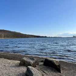
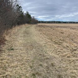
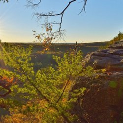
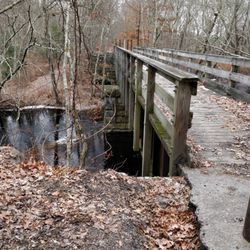
Whale Rock Preserve is a 66-acre parcel of land that The Nature Conservancy purchased to protect from further shoreline development in the area. Home to a number of migratory songbirds, the Whale Rock Trail that cuts through their habitat to the water is an enjoyable jaunt that affords interesting sights and sounds. The hike itself is easy-going. The parking area is just off Cormorant Point Road (look for the small wooden sign that reads "33" and turn in there... you'll see the Whale Rock Preserve sign and small parking lot on the right - be careful not to turn into the Camp Varnum entrance; a Rhode Island National Guard training facility). The walk starts off adjacent to some grassy fields and a private home then quickly enters the heavy brush towards the shoreline. The boardwalks that have been installed make for an easy traverse of this area. After approximately one half mile, you find yourself at the water's edge. The rest of the trail follows the shoreline next to the fenced off U.S. government grounds. Crashing waves, tons of wildflowers. Great views of Narragansett Bay! All in all, round trip gives you about 2 miles of trekking. Not long but a nice way to get out and stretch your legs. Spent some time rock hopping and picking through some seashells. Water access is not meant for swimming due to the currents but there are some tidal pools to poke around in. I'm not into birding myself but it sounds like a great spot during the migratory months.

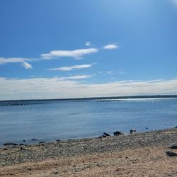
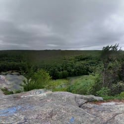
Cool trail & fun walk to a rocky beach with awesome views. It was a hot day and we decided to check it out. There were only a few cars in the tiny lot. Could be tough to find the parking lot and trailhead because it's off a dirt road. But the GPS -- use "33 Cormorant Point Road" -- took us right there like Andrea P. said in her review. Well cared for, the trail is wide and vegetation is trimmed back. A boardwalk makes it easy to walk -- but if you are in a wheelchair or hauling a stroller-- the boardwalk does not cover the entire trail so you might have a tough time in parts. There are plenty of tree roots and rocks to traverse over, however, it's not hilly. And, there were just a few souls out and about -- families with kids and dogs. The walk isn't long and you can hear the ocean before you get to the beach. The view is panoramic Narragansett Bay with a good view of Beavertail Lighthouse in Jamestown. People were fishing, exploring the coast, and we even saw someone painting. Nothing says New England like a rocky shoreline. Enjoy!

This place is so cool. It's a little confusing to find. Plug 33 Cormorant Point Rd into gps this will make it easier. You will take a left onto a little dirt road, you will be facing the entrance to the Army National Guard you do not want to go in there. Once you walk down the dirt road you will get to the end and see some big overgrown trees that lead into a little path. The path is made of these adorable little wooden bridges they will leave you out to a beach and you can walk around the perimeter of the National Guard. Wasn't much to see since it's off-season I'm really looking forward to going back more towards the spring and summer!


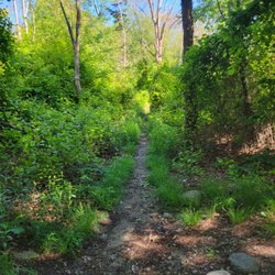
One of the best trails I've been on. Most of the trail has wooden planks, and the rest of it you're usually hugging a gate to the military base. The path from the parking lot takes you right to the waterfront, and you can continue on following the path along the gate (although I didn't go all the way around). Paths are clear and easy to follow to. As a side note, be wary of GPS. Mine wanted to take me into the military base, but the entrance road to the parking lot is next to the road to the military base; the last thing you want is the military coming after you. But the signs are clearly marked, so as long as you pay attention to the road and signs and not the GPS you should be fine. read more


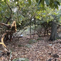
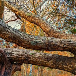
Parking lot is just inside a private dirt road. Once you turn in you'll see the Whale Rock Preserve sign. Parking is in a sunny, dirt lot to the right. Walk into the the Preserve on the dirt road by the sign. You'll pass a private residence and then onto the trail. The trail is wooded for a short time, then opens into a field. Staying on the left edge of the field, the path turns into another wooded path way. Some areas on this section of the trail have boardwalks to keep you out of the mud. Between the boardwalks are areas with lots of roots and/or rocks. There is one 'stair case' of two steps created with large, flat rocks as well. The shady, wooded areas ends when you reach the perimeter of Camp Varnum. At this point the rest of the trail is in full sun and runs along the fence line. The path opens to your left, at the first right hand turn of the fence line, onto a beach. The day we visited, something from the sea had washed up on the beach. Seagulls were dining and the stench was overwhelming. We went back to the path and followed it along the second fence line. It was a very sunny, humid day during our visit and we definitely needed our water bottles. Also, hats and sun screen are definitely needed. The path opened again to the left further along the beach onto a very rock section of coast. If you are steady on your feet, this is a fun area to explore. After a while exploring that area, we proceeded on the path to the end of the trail. Here you will find a small beach area with some sand. You could probably have a picnic in this area and if you bring water shoes, take a dip in the ocean. This is a 'there and back again' trail of about a mile all together. So not long at all. Although level, the wooded section has a lot of under foot obstacles that may make it a little difficult for small humans and definitely not good for anything with wheels. It is however, a nice, quiet walk to the ocean where you can listen to the waves and soak up the sun. read more


Whale Rock Preserve is a 66-acre parcel of land that The Nature Conservancy purchased to protect from further shoreline development in the area. Home to a number of migratory songbirds, the Whale Rock Trail that cuts through their habitat to the water is an enjoyable jaunt that affords interesting sights and sounds. The hike itself is easy-going. The parking area is just off Cormorant Point Road (look for the small wooden sign that reads "33" and turn in there... you'll see the Whale Rock Preserve sign and small parking lot on the right - be careful not to turn into the Camp Varnum entrance; a Rhode Island National Guard training facility). The walk starts off adjacent to some grassy fields and a private home then quickly enters the heavy brush towards the shoreline. The boardwalks that have been installed make for an easy traverse of this area. After approximately one half mile, you find yourself at the water's edge. The rest of the trail follows the shoreline next to the fenced off U.S. government grounds. Crashing waves, tons of wildflowers. Great views of Narragansett Bay! All in all, round trip gives you about 2 miles of trekking. Not long but a nice way to get out and stretch your legs. Spent some time rock hopping and picking through some seashells. Water access is not meant for swimming due to the currents but there are some tidal pools to poke around in. I'm not into birding myself but it sounds like a great spot during the migratory months. read more


Cool trail & fun walk to a rocky beach with awesome views. It was a hot day and we decided to check it out. There were only a few cars in the tiny lot. Could be tough to find the parking lot and trailhead because it's off a dirt road. But the GPS -- use "33 Cormorant Point Road" -- took us right there like Andrea P. said in her review. Well cared for, the trail is wide and vegetation is trimmed back. A boardwalk makes it easy to walk -- but if you are in a wheelchair or hauling a stroller-- the boardwalk does not cover the entire trail so you might have a tough time in parts. There are plenty of tree roots and rocks to traverse over, however, it's not hilly. And, there were just a few souls out and about -- families with kids and dogs. The walk isn't long and you can hear the ocean before you get to the beach. The view is panoramic Narragansett Bay with a good view of Beavertail Lighthouse in Jamestown. People were fishing, exploring the coast, and we even saw someone painting. Nothing says New England like a rocky shoreline. Enjoy! read more


This place is so cool. It's a little confusing to find. Plug 33 Cormorant Point Rd into gps this will make it easier. You will take a left onto a little dirt road, you will be facing the entrance to the Army National Guard you do not want to go in there. Once you walk down the dirt road you will get to the end and see some big overgrown trees that lead into a little path. The path is made of these adorable little wooden bridges they will leave you out to a beach and you can walk around the perimeter of the National Guard. Wasn't much to see since it's off-season I'm really looking forward to going back more towards the spring and summer! read more


What a nice trail with much of it a boardwalk so springtime mud wasn't a huge issue. Nice views to beaver tail light and Whale Rock. If you continue right along the fence of Camp Varnum , there are two other rocky beaches. Limited parking and trailhead not easily visible. read more


4 years ago
9 years ago
11 years ago
Easy walk, great for dogs, families, goes to the shore....no swimming, has dangerous rocks and currents ! read more

More info about Whale Rock Trail
Cormorant Point Rd
Narragansett, RI 02882
Directions
Hours
Outdoor Amenities
Ask the Community - Whale Rock Trail
Review Highlights - Whale Rock Trail
You might also consider


Why does Yelp recommend reviews?
1 review that is not currently recommended
The reviews below are not factored into the business's overall star rating.
5 years ago
Whale Rock Trail - hiking - Updated June 2026
Best of Narragansett
People found Whale Rock Trail by searching for…
Things to Do in Narragansett, Rhode Island
Beaches in Narragansett, Rhode Island
Fishing in Narragansett, Rhode Island
Walking Trails in Narragansett, Rhode Island
Campgrounds in Narragansett, Rhode Island
Parks in Narragansett, Rhode Island
Hiking Trails in Narragansett, Rhode Island
Secluded Spots in Narragansett, Rhode Island
Things to Do on a Rainy Day in Narragansett, Rhode Island
Beautiful Views in Narragansett, Rhode Island
Running Trails in Narragansett, Rhode Island
Secret Spots in Narragansett, Rhode Island
Picnic Areas in Narragansett, Rhode Island
Dog Swimming in Narragansett, Rhode Island
Swimming Lakes in Narragansett, Rhode Island
Boardwalk in Narragansett, Rhode Island
Scenic Views in Narragansett, Rhode Island
Off Road Trails in Narragansett, Rhode Island
Picnic Spots in Narragansett, Rhode Island
Natural Hot Springs in Narragansett, Rhode Island
Places to Walk Around in Narragansett, Rhode Island
Nature in Narragansett, Rhode Island
Trending Searches in Narragansett, RI
Bird Sanctuary near Whale Rock Trail
Black Owned Nail Salons near Whale Rock Trail
Boat Rental near Whale Rock Trail
Cliff Jumping near Whale Rock Trail
Day Trips near Whale Rock Trail
Dog Friendly Trails near Whale Rock Trail
Fishing Spots near Whale Rock Trail
Free Kids Activities near Whale Rock Trail
Jet Ski Rental near Whale Rock Trail
Lakes & Ponds near Whale Rock Trail
Off Road Trails near Whale Rock Trail
Outdoor Activities near Whale Rock Trail
Pick Your Own Farms near Whale Rock Trail
Places To Walk Around near Whale Rock Trail
Public Shower near Whale Rock Trail
Rock Quarry near Whale Rock Trail
Scenic Drive near Whale Rock Trail
Secluded Spots near Whale Rock Trail
Soccer Store near Whale Rock Trail
Splash Pad near Whale Rock Trail
Strawberry Picking near Whale Rock Trail
Sunrise View near Whale Rock Trail
Swimming Holes near Whale Rock Trail
Swimming Lakes near Whale Rock Trail
Swimming Pools near Whale Rock Trail
Watch Sunset near Whale Rock Trail
Browse Articles
Browse Nearby
BEST of Narragansett, Rhode Island Coffee near Whale Rock Trail
BEST of Narragansett, Rhode Island Restaurants near Whale Rock Trail
BEST of Narragansett, Rhode Island Parks near Whale Rock Trail
BEST of Narragansett, Rhode Island Things to Do near Whale Rock Trail
BEST of Narragansett, Rhode Island Beaches near Whale Rock Trail
BEST of Narragansett, Rhode Island Breakfast near Whale Rock Trail
Browse Brands
Related Searches in Narragansett, RI
Affordable Kayak Rental Services in Narragansett, Rhode Island
Best Fishing Locations and Guides in Narragansett, Rhode Island
Best Places for Horseback Riding in Narragansett, Rhode Island
Best Places for Stunning Views in Narragansett, Rhode Island
Check Out Off Road Trails in Narragansett, Rhode Island
Discover Dog Friendly Trails to Explore in Narragansett, Rhode Island
Discover Kid Friendly Hiking Trails in Narragansett, Rhode Island
Discover Scenic Bike Paths in Narragansett, Rhode Island
Discover Scenic Mountain Bike Trails Near Narragansett, Rhode Island
Discover a Hiking Trail in Narragansett, Rhode Island
Discover the Best Night Hike Trails in Narragansett, Rhode Island
Discover the Best Running Track in Narragansett, Rhode Island
Dog-Friendly Hikes With Dogs in Narragansett, Rhode Island
Enjoy Camping Adventures Around Narragansett, Rhode Island
Enjoy Exciting Mountain Biking Adventures in Narragansett, Rhode Island
Enjoy Kayaking Adventures in Narragansett, Rhode Island
Enjoy Tent Camping Spots Around Narragansett, Rhode Island
Enjoy Water Activities and Fun in Narragansett, Rhode Island
Enjoy the Best Walking Trails in Narragansett, Rhode Island
Exciting Cliff Jumping Spots in Narragansett, Rhode Island
Explore Beautiful Parks and Green Spaces in Narragansett, Rhode Island
Explore Easy Hikes Perfect for All in Narragansett, Rhode Island
Explore Fun Activities to Do in Narragansett, Rhode Island
Explore Popular Campgrounds Near Narragansett, Rhode Island
Explore Popular Scenic Overlook Points in Narragansett, Rhode Island
Explore the Best Beach Spots in Narragansett, Rhode Island
Explore the Best Swimming Holes Around Narragansett, Rhode Island
Explore the Best Trail Options in Narragansett, Rhode Island
Family Friendly Hiking With Kids in Narragansett, Rhode Island
Find Beautiful Views in Narragansett, Rhode Island
Find Parks and Recreation Activities in Narragansett, Rhode Island
Find Popular Ziplining Spots Around Narragansett, Rhode Island
Find the Best Parks for Picnics in Narragansett, Rhode Island
Find the Best Scenic View Locations in Narragansett, Rhode Island
Hiking Trails With Waterfalls in Narragansett, Rhode Island
Must-See Sights to Explore in Narragansett, Rhode Island
Plan a Scenic Drive Route Near Narragansett, Rhode Island
Popular Fishing Spots to Explore in Narragansett, Rhode Island
Popular Outdoor Activities to Try in Narragansett, Rhode Island
Popular Picnic Spots to Visit in Narragansett, Rhode Island
Popular Things to Do in Narragansett, Rhode Island
Safe River Swimming Areas in Narragansett, Rhode Island
Safe and Fun Parks for Kids in Narragansett, Rhode Island
Top Paddleboarding Activities in Narragansett, Rhode Island
Top Places for Snorkeling in Narragansett, Rhode Island
Top Running Trails to Explore in Narragansett, Rhode Island
Top Swimming Lakes to Enjoy in Narragansett, Rhode Island
Top Swimming Spots and Pools in Narragansett, Rhode Island
Top Things to Do With Kids in Narragansett, Rhode Island
Walk Dog Friendly Hiking Trails in Narragansett, Rhode Island
People who viewed Whale Rock Trail also viewed
Sachuest Point National Wildlife Refuge
65 reviews
The Forty Steps
41 reviews
Sakonnet Greenway Trail
1 review
Biscuit City Trail
2 reviews
Francis Carter Memorial Preserve
3 reviews
Queen's River Nature Preserve
2 reviews
King Park
19 reviews
Yawgoo Pond Trail
2 reviews
Godena Farm
2 reviews
Wickaboxet Wildlife Management Area
3 reviews