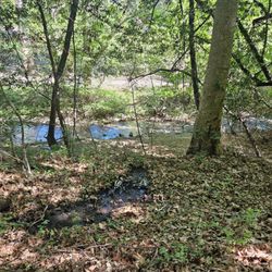
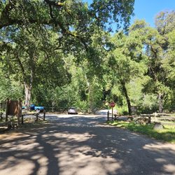
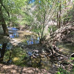
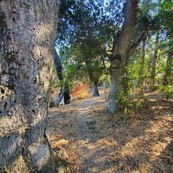
Tony Look Trail Photos


You might also consider
More like Tony Look Trail
Recommended Reviews - Tony Look Trail
Start your review...

Reviews With Photos

When encountering people riding horses on the trails, it's important to be mindful and considerate. Horses can be easily spooked, which can lead to serious and even deadly accidents. For the safety of everyone, please ensure that your dogs are kept on a leash and your children are supervised at all times. Unfortunately, I witnessed a terrifying incident last week where a child chased me and my horse with a tree branch while screaming. My horse became extremely frightened and began to bolt at 45 miles per hour. We were on a narrow road, and the situation could have led to a fatal fall into the nearby creek. Horses are prey animals and are not used to sudden movements or loud noises. If you encounter a horse while biking, it's best to slow down and talk to the rider before passing, especially if you're moving at high speed. This will help the horse understand that you are not a threat. It's also crucial that you prevent your dogs from chasing horses, as a kick from a horse can be fatal for a dog. Please refrain from bringing an umbrella on the trail, as this could also spook the horses. As equestrians, we always aim to be respectful of other trail users. We don't chase after your children or dogs, and we always yield to bikers when necessary. We don't aim to make anyone feel scared or intimidated on the trails, and we ask that you extend the same courtesy for everyone's safety. Sharing trails with bikers and people is an important aspect of outdoor recreation, especially for those who enjoy hiking and horseback riding. However, not everyone is aware of the best practices for sharing these trails safely and respectfully. That's why it's important to make sure that everyone who uses these trails has at least a basic understanding of how to share the trails with others. One way to achieve this is by making it mandatory for individuals to complete a short online course before obtaining a license for trail use. This course could cover topics such as trail etiquette, safety guidelines, and tips for sharing the trail with other users. For none horse people in particular, it's important to understand that horses can be easily spooked by sudden movements and loud noises. This means that bikers and other hikers should approach horses slowly and calmly, and give them plenty of space to pass by. By taking these simple steps to educate trail users, we can help ensure that everyone can enjoy the great outdoors safely and responsibly.

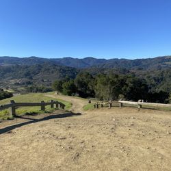
This is a moderate trail with most of the trail provide tree cover. I started the trail at 4 PM. The trail was quite empty not a lot of foot traffic initially. We had checked on alltrails and it listed as 5.4 miles. Once we started and were like 3.5 miles into the trail, our 7 month old puppy was already very tired because of the heat and on GPS it didnt seem like we were more than half way done, it seemed we were barely half way. We left 2 friends and puppy at a picnic spot and ran towards the trail to quickly go and get the car. Eventually there was 3.3 miles still left. Maths. The trail starts half miles after the parking spot, hence that 1 additional mile to listed 5.4 and probably another 0.4 mile might be the error in the trail, I ended up logging 6.8 miles on a 5.4 mile trail. In the initial parts, you might be walking along side the lake which is fun. The best view was at the top, 1 mile before the trail end. We were at the hill top from where you could see the whole San Jose valley and that could possibly be a good sunrise and sunset spot. You can consider to go either very early in morning or just before sunset, just be smart and start the trail from opposite end.


7 months ago
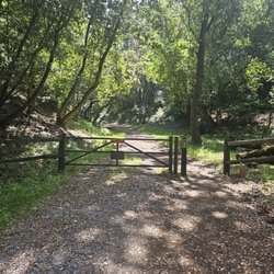
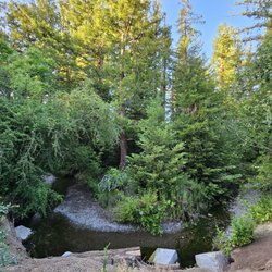
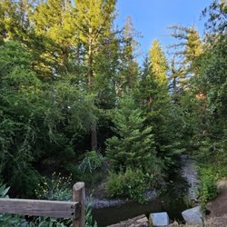
This is one of many trails at Stevens Creek County Park and the surrounding area. I parked along Stevens Canyon Road where there is limited free parking. There are also several different parking lots available for a fee (Rim Trail, Stevens Creek Chestnut, etc.). I went running here on Saturday, and though there was a bit of mud along the dirt path, I was lucky to catch a few hours of sunshine on this winter day. The Tony Look Trail is flatter and easier than other trails in the area, with manageable inclines. Alongside the flowing creek, it leads to and wraps around the Stevens Creek Reservoir until it connects to the Loop Trail. At that point, staying on Tony Look would entail more zigzagging than I was in the mood for, especially with the forecasted rains, so I split onto the Loop Trail to continue further along the water, before trekking back. There was lots of beautiful scenery to explore and appreciate, as well as a few park benches among the trees and greenery. I didn't encounter any animals nor pesky flying insects during my recent run, and there were very few people too. The peaceful atmosphere was all I could have asked for on this pleasant day. read more


4 years ago
Great out and back trail. The trail map says 45 minutes for a 2.5 mile walk, but plan for a little longer if you bring a dog. Puppy needs time to sniff right? Stevens creek was running even during the drought. The reservoir was very low and closed to all water activities. You could see the boat ramp high and dry. But we've kayaked here before, and it's a nice spot. AllTrails says it's an easy hike, but there is one steep section. The rest is fairly flat. There's a nice mix of shade and sunny parts of the trail. There are a few benches along the way to admire the view. read more


10 months ago
3 years ago
When encountering people riding horses on the trails, it's important to be mindful and considerate. Horses can be easily spooked, which can lead to serious and even deadly accidents. For the safety of everyone, please ensure that your dogs are kept on a leash and your children are supervised at all times. Unfortunately, I witnessed a terrifying incident last week where a child chased me and my horse with a tree branch while screaming. My horse became extremely frightened and began to bolt at 45 miles per hour. We were on a narrow road, and the situation could have led to a fatal fall into the nearby creek. Horses are prey animals and are not used to sudden movements or loud noises. If you encounter a horse while biking, it's best to slow down and talk to the rider before passing, especially if you're moving at high speed. This will help the horse understand that you are not a threat. It's also crucial that you prevent your dogs from chasing horses, as a kick from a horse can be fatal for a dog. Please refrain from bringing an umbrella on the trail, as this could also spook the horses. As equestrians, we always aim to be respectful of other trail users. We don't chase after your children or dogs, and we always yield to bikers when necessary. We don't aim to make anyone feel scared or intimidated on the trails, and we ask that you extend the same courtesy for everyone's safety. Sharing trails with bikers and people is an important aspect of outdoor recreation, especially for those who enjoy hiking and horseback riding. However, not everyone is aware of the best practices for sharing these trails safely and respectfully. That's why it's important to make sure that everyone who uses these trails has at least a basic understanding of how to share the trails with others. One way to achieve this is by making it mandatory for individuals to complete a short online course before obtaining a license for trail use. This course could cover topics such as trail etiquette, safety guidelines, and tips for sharing the trail with other users. For none horse people in particular, it's important to understand that horses can be easily spooked by sudden movements and loud noises. This means that bikers and other hikers should approach horses slowly and calmly, and give them plenty of space to pass by. By taking these simple steps to educate trail users, we can help ensure that everyone can enjoy the great outdoors safely and responsibly. read more

This is a moderate trail with most of the trail provide tree cover. I started the trail at 4 PM. The trail was quite empty not a lot of foot traffic initially. We had checked on alltrails and it listed as 5.4 miles. Once we started and were like 3.5 miles into the trail, our 7 month old puppy was already very tired because of the heat and on GPS it didnt seem like we were more than half way done, it seemed we were barely half way. We left 2 friends and puppy at a picnic spot and ran towards the trail to quickly go and get the car. Eventually there was 3.3 miles still left. Maths. The trail starts half miles after the parking spot, hence that 1 additional mile to listed 5.4 and probably another 0.4 mile might be the error in the trail, I ended up logging 6.8 miles on a 5.4 mile trail. In the initial parts, you might be walking along side the lake which is fun. The best view was at the top, 1 mile before the trail end. We were at the hill top from where you could see the whole San Jose valley and that could possibly be a good sunrise and sunset spot. You can consider to go either very early in morning or just before sunset, just be smart and start the trail from opposite end. read more


I need to do more research to really understand what exactly is the Tony Look Trail. It felt like I was on it for a while and then on another trail and then back on it. Does not matter...these trails are wonderful and we had an enjoyable morning hiking it. read more


5 years ago
13 years ago
17 years ago
14 years ago
11 years ago
Lovely outdoors hiking trail and beautiful scenery! Definitely good for the whole family. You can explore all around the whole area too read more


11 years ago
14 years ago
More info about Tony Look Trail
Tony Look Trail Reviews in Other Languages
Ask the Community - Tony Look Trail
Review Highlights - Tony Look Trail


Tony Look Trail - hiking - Updated July 2026
Best of Cupertino
People found Tony Look Trail by searching for…
Swimming Holes in Cupertino, CA
Hiking Trails in Cupertino, CA
Great View Points for Sunset in Cupertino, CA
Dog Friendly Hiking Trails in Cupertino, CA
Walking Trails in Cupertino, CA
Running Trails in Cupertino, CA
River Swimming in Cupertino, CA
Swimming Lakes in Cupertino, CA
Scenic Places to Walk in Cupertino, CA
Beautiful Views in Cupertino, CA
Trending Searches in Cupertino, CA
Blueberry Picking near Tony Look Trail
Cliff Jumping near Tony Look Trail
Cruising Spots near Tony Look Trail
Day Trips near Tony Look Trail
Dog Friendly Things To Do near Tony Look Trail
Kayak Rental near Tony Look Trail
Kids Activities Indoor near Tony Look Trail
Lookout Points near Tony Look Trail
Off Road Trails near Tony Look Trail
Outdoor Activities near Tony Look Trail
Peach Picking near Tony Look Trail
Public Shower near Tony Look Trail
River Swimming near Tony Look Trail
Rock Quarry near Tony Look Trail
Scenic Drive near Tony Look Trail
Sunrise View near Tony Look Trail
Surf Shop near Tony Look Trail
Swimming Holes near Tony Look Trail
Things To Do On A Rainy Day near Tony Look Trail
U Pick Farms near Tony Look Trail
Watch Sunset near Tony Look Trail
Browse Articles
Browse Nearby
BEST of Cupertino, California Coffee near Tony Look Trail
BEST of Cupertino, California Restaurants near Tony Look Trail
BEST of Cupertino, California Things to Do near Tony Look Trail
BEST of Cupertino, California Walking Trails near Tony Look Trail
BEST of Cupertino, California Parks near Tony Look Trail
BEST of Cupertino, California Breakfast near Tony Look Trail
BEST of Cupertino, California Campgrounds near Tony Look Trail
Browse Brands
Related Searches in Cupertino, CA
Affordable Kayak Rental Services in Cupertino, California
Best Dog Hiking Trails Around Cupertino, California
Best Fishing Locations and Guides in Cupertino, California
Best Nature Trails for Hiking in Cupertino, California
Best Places for Horseback Riding in Cupertino, California
Check Out Off Road Trails in Cupertino, California
Discover Dog Friendly Trails to Explore in Cupertino, California
Discover Easy Hiking Trails Near Cupertino, California
Discover Kid Friendly Hiking Trails in Cupertino, California
Discover Popular Bike Trails in Cupertino, California
Discover Scenic Mountain Bike Trails Near Cupertino, California
Discover Walking Parks in Cupertino, California Near You
Discover a Hiking Trail in Cupertino, California
Discover the Best Night Hike Trails in Cupertino, California
Dog-Friendly Hikes With Dogs in Cupertino, California
Enjoy Camping Adventures Around Cupertino, California
Enjoy Kayaking Adventures in Cupertino, California
Enjoy Off Leash Dog Hikes in Cupertino, California
Enjoy Scenic Places to Walk in Cupertino, California
Enjoy Tent Camping Spots Around Cupertino, California
Enjoy a Beautiful Waterfall Hike in Cupertino, California
Enjoy the Best Walking Path in Cupertino, California
Enjoy the Best Walking Trails in Cupertino, California
Explore Beautiful Parks and Green Spaces in Cupertino, California
Explore Easy Hikes Perfect for All in Cupertino, California
Explore Fun Activities to Do in Cupertino, California
Explore Popular Campgrounds Near Cupertino, California
Explore Popular Dog Walking Trails in Cupertino, California
Explore Top Dog Parks in Cupertino, California Near You
Explore the Best Beach Spots in Cupertino, California
Family Friendly Hiking With Kids in Cupertino, California
Find Parks and Recreation Activities in Cupertino, California
Find Top Dog Friendly Parks to Visit in Cupertino, California
Find Top-Rated Waterfalls in Cupertino, California Now
Find the Best Parks for Picnics in Cupertino, California
Hiking Trails With Waterfalls in Cupertino, California
Off Leash Dog Hiking Trails in Cupertino, California
Popular Outdoor Activities to Try in Cupertino, California
Popular Picnic Spots to Visit in Cupertino, California
Popular Waterfall Hiking Trails in Cupertino, California
Safe River Swimming Areas in Cupertino, California
Safe and Fun Parks for Kids in Cupertino, California
Top Hiking Trails to Explore in Cupertino, California
Top Playgrounds for Kids to Enjoy in Cupertino, California
Top Running Trails to Explore in Cupertino, California
Top Swimming Lakes to Enjoy in Cupertino, California
Top Swimming Spots and Pools in Cupertino, California
Top-Rated Camping Sites in Cupertino, California
People who viewed Tony Look Trail also viewed
Black Mountain Trail
42 reviews
San Tomas Aquino Creek Trail/Saratoga Creek Trail Reach 5
13 reviews
Stevens Creek County Park
79 reviews
Fremont Older Open Space Preserve
186 reviews
Hunter's Point
36 reviews
Hetch Hetchy Trail
4 reviews
Picchetti Ranch Open Space Preserve
57 reviews
Monte Bello Open Space Preserve
56 reviews
San Tomas Aquino Creek Trail
61 reviews
Saratoga Creek Trail
5 reviews
West San Jose