Ygnacio Canal Trail Photos


You might also consider
More like Ygnacio Canal Trail
Recommended Reviews - Ygnacio Canal Trail
Start your review...

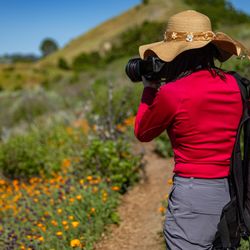
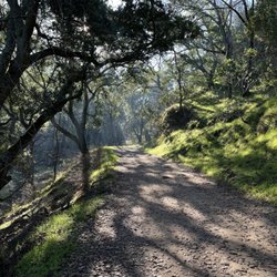
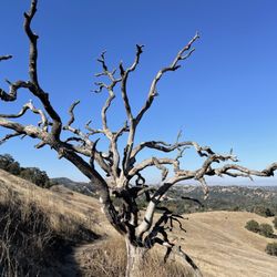
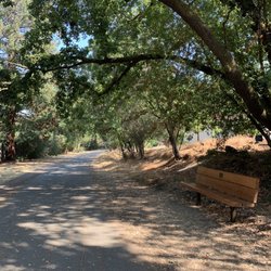
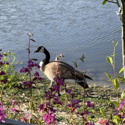
The Ygnacio Canal Trail is one of my favorite walking and running trails in the Walnut Creek area! Located in the Ygnacio Valley hills, this trail extends about 7 and a half miles from Citrus Avenue in Walnut Creek to Heather Farms Park. This trail can be accessed from several different residential streets in Walnut Creek and it also intersects the Contra Costa Canal and California Hiking and Riding trails. There are loads of beautiful scenic views and all types of different wildlife present throughout. The trail runs parallel to the Ygnacio canal where you can view the adorable ducks swimming alongside. The trail is easy to moderate, given the rolling hills at the beginning near Citrus ave. The trail passes through a few different parks and golf courses, one of which is the Arbolado Community Park. I sometimes park my car at the park and continue on the trail from Arbolado blvd. I haven't yet been able to finish this trail in one sitting since it is 7 miles long. However, I have traveled along the entire trail to its' end at the beautiful Heather Farms Park. The people on this trail are always super friendly. This trail is shared use, so people walk, run, and ride their bikes. At it's highest point, you will capture the gorgeous views of Walnut Creek and Mount Diablo in the distance. Lime Ridge Open space can also be accessible from the tunnel overpass near Ygnacio Valley Blvd. In the summertime, this trail can be sweltering in areas that aren't shaded. I've seen ducks, squirrels, and even cows roaming around in the hills. If you are looking for a new trail to conquer in the Contra Costa area, add this one to your list! read more


9 years ago
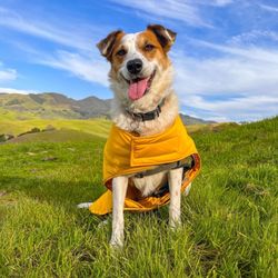
Thanks to fellow Yelper Shayla B. I can finally put a name to this trail that I've been walking for many years! On days when I don't feel like heading down to the Iron Horse Trail or the Contra Costa Canal trail, but feeling like a paved hike/walk, the Ygnacio Canal Trail hits the spot. There are several access points to the trail in Walnut Creek residential areas, but I tend to pick up behind the parking lot of John Muir, right off La Casa Via. If you follow the Briones to Mt. Diablo paved path to the left behind the hospital and go past the parking lot and curve down a small hill, you soon see the sign for this trail. I make a right and walk for 30 minutes or so until I feel like turning around. It's much quieter and serene than the Iron Horse Trail but I think word is getting out there because on a recent weekday morning I encountered more fellow trail users than ever before. Still, it's a pleasant journey along the trail with a lot of friendly folks saying hello and sharing the trail. Lots of dog walkers, joggers, and some bikes. There are several access points that intersect with Walnut Creek neighborhoods and great places to jump off if you need to get on surface streets towards dusk (there were a few times I went so far that I knew I didn't have time to make it back before dark so I hopped off the trail and took the more well lit surface streets.) During the winter, the canal flows nicely and in spring duck families call it home. It runs to a trickle in the summer but still has some ducks lingering as well as a plethora of squirrels & other birds to admire. A great alternative to other local trails, flat wide paths and local access make the Ygnacio Canal Trail a lesser known Walnut Creek gem. read more


 - Hiking Near Me")
More info about Ygnacio Canal Trail
Walnut Creek, CA 94595
Directions
Hours
Outdoor Amenities
You might also consider


Ygnacio Canal Trail - hiking - Updated July 2026
Best of Walnut Creek
People found Ygnacio Canal Trail by searching for…
Hiking Trails in Walnut Creek, CA
Walking Trails in Walnut Creek, CA
Scenic View in Walnut Creek, CA
Running Trails in Walnut Creek, CA
Sunset View in Walnut Creek, CA
Easy Hikes in Walnut Creek, CA
Shaded Hike in Walnut Creek, CA
Beautiful Views in Walnut Creek, CA
Walking Groups in Walnut Creek, CA
Secret Spots in Walnut Creek, CA
Parks for Kids in Walnut Creek, CA
Bike Paths in Walnut Creek, CA
Dirt Bike Riding in Walnut Creek, CA
Fall Foliage in Walnut Creek, CA
Off Road Trails in Walnut Creek, CA
Swimming Lakes in Walnut Creek, CA
Dog Friendly Hiking Trails in Walnut Creek, CA
Photo Spots in Walnut Creek, CA
Things to Do in Walnut Creek, CA
Trending Searches in Walnut Creek, CA
Beautiful Views near Ygnacio Canal Trail
Blueberry Picking near Ygnacio Canal Trail
Boat Tours near Ygnacio Canal Trail
Cliff Jumping near Ygnacio Canal Trail
Day Trips near Ygnacio Canal Trail
Dog Friendly Trails near Ygnacio Canal Trail
Free Picnic Areas near Ygnacio Canal Trail
Jet Ski Rental near Ygnacio Canal Trail
Kayak Rental near Ygnacio Canal Trail
Kids Activities Indoor near Ygnacio Canal Trail
Lakes near Ygnacio Canal Trail
Lookout Points near Ygnacio Canal Trail
Nature Trails near Ygnacio Canal Trail
Night Hike near Ygnacio Canal Trail
Off Road Trails near Ygnacio Canal Trail
Outdoor Activities near Ygnacio Canal Trail
Parks near Ygnacio Canal Trail
Peach Picking near Ygnacio Canal Trail
Picnic Spots near Ygnacio Canal Trail
Places To Walk Around near Ygnacio Canal Trail
Public Shower near Ygnacio Canal Trail
Rainy Day Activities near Ygnacio Canal Trail
River Swimming near Ygnacio Canal Trail
Rock Quarry near Ygnacio Canal Trail
Scenic Night View near Ygnacio Canal Trail
Scenic Overlook near Ygnacio Canal Trail
State Parks near Ygnacio Canal Trail
Swimming Holes near Ygnacio Canal Trail
Swimming Lakes near Ygnacio Canal Trail
Things To Do On A Rainy Day near Ygnacio Canal Trail
Things To Do With Teenagers near Ygnacio Canal Trail
Tubing near Ygnacio Canal Trail
View Points near Ygnacio Canal Trail
Watch Sunset near Ygnacio Canal Trail
Water Parks near Ygnacio Canal Trail
Browse Nearby
BEST of Walnut Creek, California Restaurants near Ygnacio Canal Trail
BEST of Walnut Creek, California Coffee near Ygnacio Canal Trail
BEST of Walnut Creek, California Things to Do near Ygnacio Canal Trail
BEST of Walnut Creek, California Beaches near Ygnacio Canal Trail
BEST of Walnut Creek, California Parks near Ygnacio Canal Trail
BEST of Walnut Creek, California Campgrounds near Ygnacio Canal Trail
BEST of Walnut Creek, California Breakfast near Ygnacio Canal Trail
BEST of Walnut Creek, California Lodging near Ygnacio Canal Trail
BEST of Walnut Creek, California Motel near Ygnacio Canal Trail
Browse Brands
Related Searches in Walnut Creek, CA
Affordable Bike Repair Services in Walnut Creek, California
Affordable Bike Tune Up Services in Walnut Creek, California
Affordable Cheap Bike Tune Up Services in Walnut Creek, California
Affordable Kayak Rental Services in Walnut Creek, California
Best Dirt Bike Riding Spots in Walnut Creek, California
Best Dog Hiking Trails Around Walnut Creek, California
Best Electric Bike Rental Services in Walnut Creek, California
Best Fishing Locations and Guides in Walnut Creek, California
Best Nature Trails for Hiking in Walnut Creek, California
Best Places for Horseback Riding in Walnut Creek, California
Best Sightseeing Experiences Available in Walnut Creek, California
Check Out Off Road Trails in Walnut Creek, California
Convenient Bike Sharing Programs in Walnut Creek, California
Discover Dog Friendly Trails to Explore in Walnut Creek, California
Discover Easy Hiking Trails Near Walnut Creek, California
Discover Kid Friendly Hiking Trails in Walnut Creek, California
Discover Popular Bike Tours in Walnut Creek, California
Discover Popular Bike Trails in Walnut Creek, California
Discover Scenic Bike Paths in Walnut Creek, California
Discover Scenic Mountain Bike Trails Near Walnut Creek, California
Discover Walking Parks in Walnut Creek, California Near You
Discover a Hiking Trail in Walnut Creek, California
Discover the Best Night Hike Trails in Walnut Creek, California
Dog-Friendly Hikes With Dogs in Walnut Creek, California
Enjoy Biking Adventures Around Walnut Creek, California
Enjoy Camping Adventures Around Walnut Creek, California
Enjoy Hiking Adventures in Walnut Creek, California
Enjoy Kayaking Adventures in Walnut Creek, California
Enjoy Off Leash Dog Hikes in Walnut Creek, California
Enjoy Scenic Dirt Bike Trails Around Walnut Creek, California
Enjoy Scenic Places to Walk in Walnut Creek, California
Enjoy a Beautiful Waterfall Hike in Walnut Creek, California
Enjoy the Best Walking Path in Walnut Creek, California
Enjoy the Best Walking Trails in Walnut Creek, California
Explore BMX Bike Shops Near Walnut Creek, California
Explore Beautiful Parks and Green Spaces in Walnut Creek, California
Explore Bike Rentals Throughout Walnut Creek, California
Explore Cycling Stores in Walnut Creek, California
Explore Easy Hikes Perfect for All in Walnut Creek, California
Explore Electric Bikes Available in Walnut Creek, California
Explore Fun Activities to Do in Walnut Creek, California
Explore Popular Campgrounds Near Walnut Creek, California
Explore Popular Dog Walking Trails in Walnut Creek, California
Explore Popular Scenic Views Near Walnut Creek, California
Explore Top Dog Parks in Walnut Creek, California Near You
Explore the Best Beach Spots in Walnut Creek, California
Explore the Best Rock Climbing Areas in Walnut Creek, California
Family Friendly Hiking With Kids in Walnut Creek, California
Browse Articles
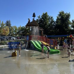
People who viewed Ygnacio Canal Trail also viewed
Acalanes Ridge Recreation Area
16 reviews
Creek Walk
7 reviews
Lime Ridge Open Space
33 reviews
Howe Homestead Park
14 reviews
Mount Diablo's Grand Loop
6 reviews
Fernandez Ranch
13 reviews
Lafayette Ridge Staging Area
1 review
Rohrer Ridge Trail
2 reviews
Sugarloaf Open Space
14 reviews
Blue Oak Shortcut Trail
2 reviews