Sullivan Canyon Preservation Photos


 - Hiking Near Me")

You might also consider
More like Sullivan Canyon Preservation
Recommended Reviews - Sullivan Canyon Preservation
Start your review...

Reviews With Photos

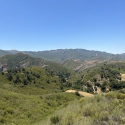
This is an 11 miles round trip hike with 1,600' elevation gain. The hike is long, but it is pretty easy overall. If you are looking for a difficult, taxing workout, this is not the hike for you. But it will help build endurance training. The trail is wide and smooth, without loose rocks under foot. The inclines are fairly tame and the trail ascends and descends. About 4 miles into the hike, you will arrive at the former NIKE Mission Control Site, which consists of a tower/overlook and a flat area with 2 restrooms. There are panoramic views of the mountains, ocean, and LA in the distance. If you continue on beyond the tower and left , you will eventually get to Sullivan Canyon (follow the sign that leads you down the smaller trail). It will take you through a heavily wooded area with lots of trees and nature. This part of the trail is flat and easy. However, we chose to take a shortcut (at a sign that indicates a preservation area) about 1+ miles from the end of the trail that ends at the paved road. This part of the trail is very, very steep and continues up for about 1/2 mile - very difficult. All in all, this trail is about endurance, not difficulty. And be mindful that you will likely encounter many dogs and cyclists along the way.

This trail has a rustic, unmanned yet magical kind of feel as you are traversing through the pebble filled road. Although I can't comment on the end view - as we didn't get to the end of the trail, the journey definitely made me a fan. The start of the trail is located on Bayliss Road, where the entrance is blocked by a gigantic banner/gate that says enter at your own risk. As a side note, don't google the location - it'll take you to some obscure place nearby that might be having an estate sale - just from experience. Instead, follow Jolene's helpful review on directions some post down, you'll get there just right. You'd have to walk along the side to get in. It's a steep hill down, then levels off. Along the trail, you are inundated with a smell of sweet sage/rosemary/wood, everything beautiful. We were frequently visited by different types of butterflies and birds along the way, who'd flutter nearby you and then run off. There's a lot of pollen everywhere and so, if you are allergic to pollen, best not come during the spring - it's everywhere. Will be back again to finish the hike next time- looking forward to it.

2 years ago
Sullivan Fire Road trail is one of the many trails within the Santa Monica mountains. The entrance is next to the privately owned Casale Ranch. On my hike, there were a lot of bikers on the trail which gave me the impression that the trail is more popular amongst bikers than walkers and runners. In fact my friends and I were constantly dodging bikers from behind or stopping on our hike to move to the left or right of the trail so that the bikers could pass. The trail is mostly paved and there are certain areas where you can catch glimpses of the mountains, like at the Camp Jospeho gate, but for the most part there is brush on either side of the trail so the views of the mountains are often hidden. read more


Nice canyon trail for a bike ride or a jog. The path is overall smooth but there are areas with a bunch of stones and it gets kinda of bumpy. Gradually incline towards the upper part. Nice and serene. Street parking but watch for signs. read more


5 years ago
12 years ago
This is an 11 miles round trip hike with 1,600' elevation gain. The hike is long, but it is pretty easy overall. If you are looking for a difficult, taxing workout, this is not the hike for you. But it will help build endurance training. The trail is wide and smooth, without loose rocks under foot. The inclines are fairly tame and the trail ascends and descends. About 4 miles into the hike, you will arrive at the former NIKE Mission Control Site, which consists of a tower/overlook and a flat area with 2 restrooms. There are panoramic views of the mountains, ocean, and LA in the distance. If you continue on beyond the tower and left , you will eventually get to Sullivan Canyon (follow the sign that leads you down the smaller trail). It will take you through a heavily wooded area with lots of trees and nature. This part of the trail is flat and easy. However, we chose to take a shortcut (at a sign that indicates a preservation area) about 1+ miles from the end of the trail that ends at the paved road. This part of the trail is very, very steep and continues up for about 1/2 mile - very difficult. All in all, this trail is about endurance, not difficulty. And be mindful that you will likely encounter many dogs and cyclists along the way. read more


This trail has a rustic, unmanned yet magical kind of feel as you are traversing through the pebble filled road. Although I can't comment on the end view - as we didn't get to the end of the trail, the journey definitely made me a fan. The start of the trail is located on Bayliss Road, where the entrance is blocked by a gigantic banner/gate that says enter at your own risk. As a side note, don't google the location - it'll take you to some obscure place nearby that might be having an estate sale - just from experience. Instead, follow Jolene's helpful review on directions some post down, you'll get there just right. You'd have to walk along the side to get in. It's a steep hill down, then levels off. Along the trail, you are inundated with a smell of sweet sage/rosemary/wood, everything beautiful. We were frequently visited by different types of butterflies and birds along the way, who'd flutter nearby you and then run off. There's a lot of pollen everywhere and so, if you are allergic to pollen, best not come during the spring - it's everywhere. Will be back again to finish the hike next time- looking forward to it. read more


15 years ago
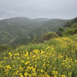
I loved hiking Sullivan Canyon cause the smells are gorgeous: white sycamore, green lavender, and canyon flowers. Beautiful scents you just won't find in the city. It's about 5 miles from the mouth of the trail to the top. Then you reach Sullivan Fire Roads and some very nice views of the city. There are a couple different loops you could do. In all, our hike was 10 miles. Favorite part: less than 7 minutes from the West Side. Least favorite part: industrial concrete mats, gas poles, and signage that tells you "hey stupid, you're still in the city". read more

12 years ago
12 years ago
12 years ago
18 years ago
14 years ago
More info about Sullivan Canyon Preservation
Pacific Palisades, CA 90272
Pacific Palisades
Directions
(310) 454-5905
Call Now
Hours
Outdoor Amenities
Ask the Community - Sullivan Canyon Preservation
Review Highlights - Sullivan Canyon Preservation
You might also consider


Sullivan Canyon Preservation - hiking - Updated July 2026
Best of Pacific Palisades
People found Sullivan Canyon Preservation by searching for…
Hiking Trails in Pacific Palisades, California
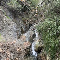
Waterfall Hike in Pacific Palisades, California
Lookout Points in Pacific Palisades, California
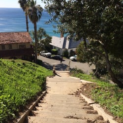
Stairs Workout in Pacific Palisades, California
Camping Cabins in Pacific Palisades, California
Sunbathing in Pacific Palisades, California
Bird Watching in Pacific Palisades, California
Walking Path in Pacific Palisades, California
Places to Walk in Pacific Palisades, California
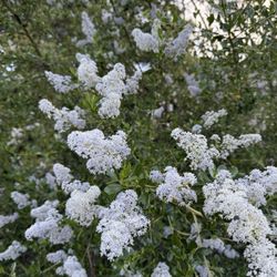
Flower Field in Pacific Palisades, California
Hiking Trails Kid Friendly in Pacific Palisades, California
Free Campgrounds in Pacific Palisades, California
Campgrounds in Pacific Palisades, California
Running Trails in Pacific Palisades, California
Easy Hikes in Pacific Palisades, California
Secret Spots in Pacific Palisades, California
Secluded Spots in Pacific Palisades, California
Things to Do in Pacific Palisades, California
Running Routes in Pacific Palisades, California
Shaded Hike in Pacific Palisades, California
Scenic Overlook in Pacific Palisades, California
Off Leash Dog Hikes in Pacific Palisades, California
Browse Nearby
BEST of Pacific Palisades, California Coffee near Sullivan Canyon Preservation
BEST of Pacific Palisades, California Restaurants near Sullivan Canyon Preservation
BEST of Pacific Palisades, California Things to Do near Sullivan Canyon Preservation
BEST of Pacific Palisades, California Breakfast near Sullivan Canyon Preservation
BEST of Pacific Palisades, California Walking Trails near Sullivan Canyon Preservation
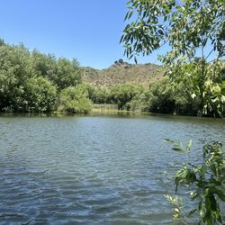
BEST of Pacific Palisades, California Parks near Sullivan Canyon Preservation
BEST of Pacific Palisades, California Campgrounds near Sullivan Canyon Preservation
BEST of Pacific Palisades, California Taxis near Sullivan Canyon Preservation
BEST of Pacific Palisades, California Hot Springs near Sullivan Canyon Preservation
Browse Brands
Browse Articles
People who viewed Sullivan Canyon Preservation also viewed
Deervale-Stone Canyon Park
16 reviews
Sherman Oaks
Getty View Trailhead
16 reviews
Bel Air
Temescal canyon Trail
10 reviews
Pacific Palisades
Fryman Canyon Park
124 reviews
Hollywood Hills West
Stone Canyon Overlook
16 reviews
Beverly Crest
Trebek Open Space
14 reviews
Hollywood Hills West
Las Virgenes Canyon
8 reviews
Saddle Peak Trail
3 reviews
Rivas Canyon Trail
11 reviews
Pacific Palisades
East Sepulveda Fire Road
9 reviews
Bel Air