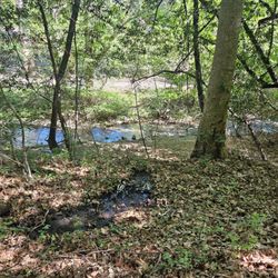
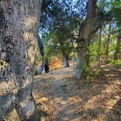
Long Ridge Open Space Preserve Photos


You might also consider
More like Long Ridge Open Space Preserve
Recommended Reviews - Long Ridge Open Space Preserve
Start your review...

Reviews With Photos - Long Ridge Open Space Preserve

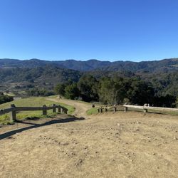
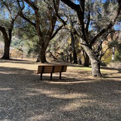
Long Ridge is probably one of the most connected preserves in the Bay Area, connecting with no less than 4 other parks: * Skyline Ridge Open Space Preserve * Upper Stevens Creek County Park (with crossings over Skyline Blvd) * Portola Redwoods State Park * Castle Rock State Park (with crossings over Hwy 9) The elevation changes in Long Ridge are not too drastic, so if you're strictly looking for a hill workout in this area, Upper Stevens Creek is more your cup of tea. Long Ridge is split roughly in half between single-track and "normal" width trails, and between shaded and unshaded. This preserve is favored by mountain bikers and hikers alike. From the ridge, you get a wide view of the tree-blanketed canyon below. In the middle of the preserve is Turtle Rock, where there's a bench and some distinctive rocks (one of which could faintly resemble a turtle). This is a popular spot for visitors to pause and enjoy the view. Note that there are no drinking fountains or restrooms in the preserve. Make sure to use the restroom before you arrive, or else you might find yourself communing with nature even more!

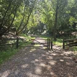
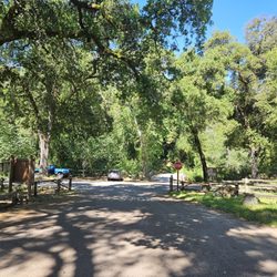
Long Ridge is one of several open space preserves strung alongside Skyline Blvd in the Santa Cruz range. I think of it as the southernmost of the 'Peninsula' OSPs, since it abuts Route 9 to the south and is bisected by the border between San Mateo and Santa Cruz Counties. At the same time, it also feels like one of the lost stepchildren of the OSPs, since unlike other nearby parks (e.g. Skyline Ridge, Castle Rock, Russian Ridge), it lacks a dedicated parking lot or facilities. With those differences aside, it does offer many of the same features of the other nearby parks, including: a combination of shady, forested paths; burbling streams; open meadows; and hilltop vistas. If broken into three pieces, the northern and southern third of the park are mostly forested, whereas the central section is comprised of open, grassy hillsides. I find the views here particularly striking, especially those from Turtle Rock, near the southern end of Hickory Oaks Trail . Due to the higher exposure in this part of the park, the best times to visit are winter, spring and fall. The other thing I appreciate about Long Ridge are the forgotten corners and less-traveled areas. There is a hidden, large sandstone rock climbing area called 'Eagle Peak' that provides some fun scrambling and more great views, plus the 'Ward Rd' trail provides a less-traveled, back entrance to Portola Redwoods SP. There are also some unmarked trails to lovely areas that are best kept a secret. Loop Hike Ideas: -- For a short (4-5 miles) and mostly forested loop: starting from Grizzly Flat, stick to the Peters Creek and Long Ridge Trails, making sure to enjoy the views at the Wallace Stegner Bench on the journey. -- For a longer 'lollipop' hike, add a there-and-back section to the loop above to reach the Turtle Rock overlook on the Hickory Oaks Trail (add'l 1.5 miles) -- Or to visit four parks and three counties, start at Saratoga Gap and loop through parts of Castle Rock SP, Long Ridge OSP, Upper Stevens Creek CP and Saratoga Gap OSP (7-11 miles depending on the route) Hiking Spot Checklist for Long Ridge: -- Parking: Roadside only - 2 entrances on Skyline Blvd; the main one is at Grizzly Flat, 3.3. miles south of Page Mill Rd intersection. (The south end can also be accessed via parking at Saratoga Gap) -- Bathrooms: No -- Potable water provided: No -- Maps provided: Yes -- Highlights: Commanding views; nice variety; not very crowded My Peninsula Hike Collection is here: (https://www.yelp.com/collection/qBI6U6Lz9LJQjnGjFW6ubg)

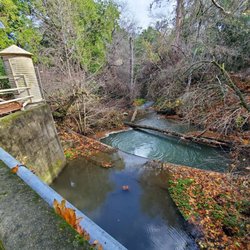
The Stegner Bench is what wooed me into curiosity. When you hear of a great view, you want to find out if its really that amazing. Well I can say it was! Well worth the trip. We took the recommended route starting at Grizzly Flat/Upper Stevens Creek County Park to Long Ridge trail. Heading towards the lookout where Stegner Bench sits, then continued on until we reached Peters Creek trail until you eventually come to the point where you started. The first part of the Long Ridge trail had only one uphill climb, then it was moderate after that. The Peters Creek trail was much less up and down, with wide, flat trail for most of the way. Too bad that the creek doesn't have any water. The only confusing part of the hike was when you get to the sign where you have to go right to Peters Creek. You see a sign that says STOP private property ahead. Just continue past the little lake area and keep left. There is a gate to the right where the private property is. I'm sure it gets a lot of traffic during the weekends. We went on a Wednesday and saw a few ppl on mountain bikes and a few hiking alone, but it was mostly very serene with it seeming we were all alone. A few gray squirrels reminded us that we weren't. One of the things I'll remember the most is how the wind would sweep through, and the sound of the leaves creating a wave of the most beautiful sound. It almost sounded like water. It's a preserve so don't plan on seeing any restrooms.

Compared to some of the other open space preserves along Skyline Boulevard, like Russian Ridge, Purisima Redwoods, or Windy Hill, Long Ridge OSP perhaps gets less attention than otherwise would be the case for such a pretty and scenic location. Often, its trails are used by mountain bikers as part of longer routes that also include stops in Stevens Creek Canyon or Monte Bello Ridge. Trail runners also enjoy Long Ridge for its moderately steep climbs (compared with Purisima, for example) and long ridgeline trails, which offer ocean views and very nice looks at Butano Ridge along the way. For hikers, it's best to come here in winter and early spring, when the hills are verdant, wet, and green. Or in summer, when the oat grasses are dry and golden and wave in the breeze while fog creeps up from the coast, quails and wild turkeys scurry about, and dragonflies and other insects flit about in the sunshine. The loops are generally less than 10 miles, and can be done in 3 hours or less. There are three benches along the main ridge for resting, having a drink of water, and taking pictures. The Wallace Stegner bench is a favorite of mine, for its sturdy stone construction, its commemorative plaque, and its attractive views looking towards the Pacific. Any way you look at it, Long Ridge is a treasure of preserved nature, one that is all the more special because of how close it is to Silicon Valley and the rapidly filling Bay Area. I sometimes feel bad for the trail runners and especially the bicyclists I see here while hiking. They seem so focused on getting a workout or not crashing their expensive, 2-wheeled vehicles that they miss out on the many millions of little things that make Long Ridge so special. Hiking speed is the best for that!

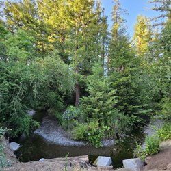
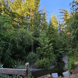
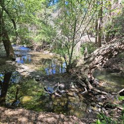
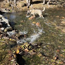
My usual haunts for hiking are in the east hills, where I enjoy open vistas on most every trail. When I want more greenery and shade, I head over to the Santa Cruz Mountains. Imagine my delight when happening on the Long Ridge Loop in the Long Ridge Open Space Preserve--both forest and views! The 4+ mile loop on the Long Ridge and Peters Creek Trails gives you a little of everything, forests and shade, water (both a pond and stream), modest climbs for cardio, and magnificent views of the Butano Ridge to the west. The trails are well-maintained and, though we were there two days after it rained, there was little mud. My only complaint is that there are no restrooms at the trailheads, so you know what happens.

Went to Long Ridge OSP on Sun 2/1/15 for a short 6 miles hike with folks. Parking is on Hwy 35 at Upper Stevens Creek County Park, Long Ridge is across the street. No bathrooms (just find a tree) and No Water - bring your own. Did Peter's Trail where you walk by the Jikoji Zen Center lake - No swimming allowed, private property, water is dirty anyways. Then we did the Long Ridge Rd, we turned Left and had lunch at Roderic Annabele bench - seats 3 people, others sat on the giant rock boulders. Did some more trails, ended up at Wallace Stegner, an author, memorial bench. Lots of mountain bikers here, not many hikers.

Perhaps the best Pacific vistas to be found along the wonderful stretch of paved highway that is Skyline Boulevard are to be found here, at Long Ridge Open Space Preserve. From the Grizzly Flat parking trailhead, it is a leisurely stroll alongside Peters Creek, past the Jikoji Zen Center pond, up to the rolling open hills and expansive ocean and redwood panoramas along Long Ridge Road. Following Long Ridge to its connection with the Hickory Oaks Trail allows you to rest at a beautifully situated bench with views that always - always - astound. When you have soaked up your weekly fill of silence and solitude, you can return to the trailhead be retracing your steps along the Long Ridge Trail back to Peters Creek. It's simple. It's uncluttered. It never ceases to cleanse the spirit, restore the mind, and reinvigorate the body. It's as cathartic as hiking in the Santa Cruz Mountains gets. And if you've never been up here before, Long Ridge offers all of the best of the preserves at a fraction of the effort you would need to expend at Purisima Creek Redwoods, El Corte de Madera, or Russian Ridge. Springtime is amazing here: green, lush, winds gusting from Monte Bello Ridge and Silicon Valley, fog crawling up the mountains from the coast, lupines blooming as early as late February. There is no better way to experience the unique nature of the Skyline than while walking the open spaces of the Long Ridge. Some days, when wind, sun, grass, and sky are all in near perfect alignment, you will never want the walk to end.

I came here early on Friday morning around 7AM and on the drive up, I saw the cloud is covering the Santa Cruz Mountain and I was excited to see it. When I got to Long Ridge, the "parking lot" is just a dirt lot and I was the only on there. It took me 2 miles to get to the view point, I was getting irritated because I thought I was going to miss the view. But at 2 mile mark, I was able to get great view of the thick, fluffy cloud covering the Santa Cruz Mountain, It was GLORIOUS! The rest of the hike are all in the forest, most of the trails are flat, and I was even able to do a light trail run. Overall, I think the best time to come is in the morning, the view is just outstanding.

The brochure for Long Ridge says it has "something for everyone". Indeed, if you take the Peters Creek-Long Ridge loop, you'll feel you're in the every-preserve: dappled by variety but short on superlatives. Follow shady Peters Creek valley to gorgeous Jikoji Pond (private property so you only get a fleeting glimpse), then up onto Long Ridge where you get views down grassy hillsides towards the ocean for a while before the generic oak forest closes in, and finally dropping back to Peters Creek again near the trailhead. There are also several extended hikes you can put together here--like a 10-mile loop that crosses Skyline Boulevard into adjacent Upper Stevens Creek County Park. Also, being at the headwaters of Pescadero Creek, you can actually hike down into Portola Redwoods State Park from here.

As I drove to one of the many trails for the first time I slowed down dramatically, not only because of the adorable cottages in the area and quaint summer homes, but due to the gorgeous greenery, trickling water, and soothing creeks. My dog also loved the scenery and kept sniffing the glorious scents of the woods. I stopped several times to take pictures but was disappointed that the beauty of the preserve could not be captured by a lens. I did not have a plan or a map when I arrived but found an uphill trail surrounded by trees and a gorgeous view of Sunnyvale. My dog tire easily on this particular path, and that is saying a WHOLE lot! I hiked for about forty five minutes and turned around when my dog refused to go any further because of the heat, I recommend going early morning in the summer and spring. I plan on going back a bit more prepared and attempting another path.

This is a great place to visit if you enjoy the outdoors, fresh air, hiking, biking and scenic views. Parking available at the top of highway 9 and 35. There are another 2 parking spots heading north on 35, one about 2 miles up the road 'side of the road parking' and the other is the grizzly flat parking area. Pick up a map and start your trek. There are a lot of mountain bikers here, so keep an eye out for them. Most are cautious when passing you on the trial, but you still need to watch for them as some of the trails are narrow 'single track'. Starting from 9/35, you can cross over 9 and take the single track to 35. Then crossover the highway up the fire road and onto the longridge trail. Proceed until you make it to the look out bench for great views of the Santa Cruz coastal area. You will often see a fog inversion layer in valleys below the mornings. If you still want to hike a little more, take the Peters Creek loop and head back to the car. Bring lots of water, sunscreen and maybe an energy bar/snacks as hit gets really hot in the summer. There is another hiking trail that heads towards Castle Rock if you head south from the main parking lot of 9/35. There are no bikes allowed on these trails, so you don't have to worry about getting hit by them or moving to the side of the trail. Great views of the entire south bay. This is by far my favorite local place to bike and enjoy the outdoors. Burn some calories from all of those restaurants you visited on Yelp!

Had a good experience hiking here! Came on a Saturday around 9:45am to hike the Long Ridge loop. I was initially worried about the parking situation but thankfully it was not crowded at all! Easily found street parking by the Peters Creek trailhead. There happened to be an ultramarathon that day, so we ran into some runners and cyclists along the way, but for the most part we had the trail to ourselves. Not much of a view but the trails are well maintained. Mostly shaded and spotted some pretty wildflowers. We went clockwise which had a gradual incline and steep descent - I would recommend going the opposite direction to save your knees or go slow/bring hiking poles. Long Ridge Loop took us a little less than 2 hours to complete and I would say it is easy-moderate hike as my dad was able to do it comfortably. Definitely recommend downloading the AllTrails map prior as there are not many signs and we would probably would have gotten lost without it. Overall, I enjoyed Long Ridge and would recommend for beginners or anyone looking for an easy, quiet hike. read more


4 years ago
Long Ridge Open Space is a quieter, seemingly overlooked park in an area that has no shortage of hiking trails. That's what makes it a nice, peaceful hike where you're likely to find parking. During a sunny Saturday afternoon, we only encountered about 5 other groups of hikers. I recommend parking at Grizzly Flat trailhead and following the signs for Peters Creek trail. You'll gently descend to a wooded area, cross a footbridge and make a left following the creek. I've heard after the rain there are rushing small cascades. I haven't timed it right to see them but the winter woods are still bright and mossy, making it a pleasant journey. Keep following the trail until you get to the gate for the Buddhist center, bear fight and follow a moderate set of switch backs up to the ridge itself. On the Long Ridge trail you'll have sweeping views of the Santa Cruz mountains and rolling green hills. Go about a mile along the ridge, dip down back in to the woods and follow the signs back to Grizzly Flat parking. There are not giant redwoods or waterfalls or even too many views (albeit the one spectacular one at the top of the ridge) but it is a pleasant, moderate woodland hike. For longer hikes it also connects with several other parks. Free parking, well signed help make this a great regional park for a quieter more low key hike. read more


My husband and I did a 4+ mile trail run at Long Ridge OSP over the weekend. This park has the perfect mix of shaded areas and sunny areas with wide open space. I believe the most popular hike/run at this park is the Peter's Creek to Long Ridge Road to the Long Ridge Trail. Peter's Creek trail involves a nice descent to a pond and then some nice uphill and switchbacks to Long Ridge Road. When you reach Long Ridge Road, you will be greeted with beautiful vistas and views. This area was my favorite part of our run. Then once on Long Ridge Trail, it will be a couple of shaded miles back to the parking lot. This park also connects to Skyline Ridge, Upper Stevens Creek, and Saratoga Gap if you looking for more miles. We loved how uncrowded this park was compared to others that we have been to. We only saw a few hikers out of the trail. There are a few parking spots along Highway 35 at the entrance of the trail head with no bathrooms. read more


Long Ridge is probably one of the most connected preserves in the Bay Area, connecting with no less than 4 other parks: * Skyline Ridge Open Space Preserve * Upper Stevens Creek County Park (with crossings over Skyline Blvd) * Portola Redwoods State Park * Castle Rock State Park (with crossings over Hwy 9) The elevation changes in Long Ridge are not too drastic, so if you're strictly looking for a hill workout in this area, Upper Stevens Creek is more your cup of tea. Long Ridge is split roughly in half between single-track and "normal" width trails, and between shaded and unshaded. This preserve is favored by mountain bikers and hikers alike. From the ridge, you get a wide view of the tree-blanketed canyon below. In the middle of the preserve is Turtle Rock, where there's a bench and some distinctive rocks (one of which could faintly resemble a turtle). This is a popular spot for visitors to pause and enjoy the view. Note that there are no drinking fountains or restrooms in the preserve. Make sure to use the restroom before you arrive, or else you might find yourself communing with nature even more! read more


4 years ago
Long Ridge is one of several open space preserves strung alongside Skyline Blvd in the Santa Cruz range. I think of it as the southernmost of the 'Peninsula' OSPs, since it abuts Route 9 to the south and is bisected by the border between San Mateo and Santa Cruz Counties. At the same time, it also feels like one of the lost stepchildren of the OSPs, since unlike other nearby parks (e.g. Skyline Ridge, Castle Rock, Russian Ridge), it lacks a dedicated parking lot or facilities. With those differences aside, it does offer many of the same features of the other nearby parks, including: a combination of shady, forested paths; burbling streams; open meadows; and hilltop vistas. If broken into three pieces, the northern and southern third of the park are mostly forested, whereas the central section is comprised of open, grassy hillsides. I find the views here particularly striking, especially those from Turtle Rock, near the southern end of Hickory Oaks Trail . Due to the higher exposure in this part of the park, the best times to visit are winter, spring and fall. The other thing I appreciate about Long Ridge are the forgotten corners and less-traveled areas. There is a hidden, large sandstone rock climbing area called 'Eagle Peak' that provides some fun scrambling and more great views, plus the 'Ward Rd' trail provides a less-traveled, back entrance to Portola Redwoods SP. There are also some unmarked trails to lovely areas that are best kept a secret. Loop Hike Ideas: -- For a short (4-5 miles) and mostly forested loop: starting from Grizzly Flat, stick to the Peters Creek and Long Ridge Trails, making sure to enjoy the views at the Wallace Stegner Bench on the journey. -- For a longer 'lollipop' hike, add a there-and-back section to the loop above to reach the Turtle Rock overlook on the Hickory Oaks Trail (add'l 1.5 miles) -- Or to visit four parks and three counties, start at Saratoga Gap and loop through parts of Castle Rock SP, Long Ridge OSP, Upper Stevens Creek CP and Saratoga Gap OSP (7-11 miles depending on the route) Hiking Spot Checklist for Long Ridge: -- Parking: Roadside only - 2 entrances on Skyline Blvd; the main one is at Grizzly Flat, 3.3. miles south of Page Mill Rd intersection. (The south end can also be accessed via parking at Saratoga Gap) -- Bathrooms: No -- Potable water provided: No -- Maps provided: Yes -- Highlights: Commanding views; nice variety; not very crowded My Peninsula Hike Collection is here: (https://www.yelp.com/collection/qBI6U6Lz9LJQjnGjFW6ubg) read more


The Stegner Bench is what wooed me into curiosity. When you hear of a great view, you want to find out if its really that amazing. Well I can say it was! Well worth the trip. We took the recommended route starting at Grizzly Flat/Upper Stevens Creek County Park to Long Ridge trail. Heading towards the lookout where Stegner Bench sits, then continued on until we reached Peters Creek trail until you eventually come to the point where you started. The first part of the Long Ridge trail had only one uphill climb, then it was moderate after that. The Peters Creek trail was much less up and down, with wide, flat trail for most of the way. Too bad that the creek doesn't have any water. The only confusing part of the hike was when you get to the sign where you have to go right to Peters Creek. You see a sign that says STOP private property ahead. Just continue past the little lake area and keep left. There is a gate to the right where the private property is. I'm sure it gets a lot of traffic during the weekends. We went on a Wednesday and saw a few ppl on mountain bikes and a few hiking alone, but it was mostly very serene with it seeming we were all alone. A few gray squirrels reminded us that we weren't. One of the things I'll remember the most is how the wind would sweep through, and the sound of the leaves creating a wave of the most beautiful sound. It almost sounded like water. It's a preserve so don't plan on seeing any restrooms. read more


9 years ago
Compared to some of the other open space preserves along Skyline Boulevard, like Russian Ridge, Purisima Redwoods, or Windy Hill, Long Ridge OSP perhaps gets less attention than otherwise would be the case for such a pretty and scenic location. Often, its trails are used by mountain bikers as part of longer routes that also include stops in Stevens Creek Canyon or Monte Bello Ridge. Trail runners also enjoy Long Ridge for its moderately steep climbs (compared with Purisima, for example) and long ridgeline trails, which offer ocean views and very nice looks at Butano Ridge along the way. For hikers, it's best to come here in winter and early spring, when the hills are verdant, wet, and green. Or in summer, when the oat grasses are dry and golden and wave in the breeze while fog creeps up from the coast, quails and wild turkeys scurry about, and dragonflies and other insects flit about in the sunshine. The loops are generally less than 10 miles, and can be done in 3 hours or less. There are three benches along the main ridge for resting, having a drink of water, and taking pictures. The Wallace Stegner bench is a favorite of mine, for its sturdy stone construction, its commemorative plaque, and its attractive views looking towards the Pacific. Any way you look at it, Long Ridge is a treasure of preserved nature, one that is all the more special because of how close it is to Silicon Valley and the rapidly filling Bay Area. I sometimes feel bad for the trail runners and especially the bicyclists I see here while hiking. They seem so focused on getting a workout or not crashing their expensive, 2-wheeled vehicles that they miss out on the many millions of little things that make Long Ridge so special. Hiking speed is the best for that! read more


8 years ago
My usual haunts for hiking are in the east hills, where I enjoy open vistas on most every trail. When I want more greenery and shade, I head over to the Santa Cruz Mountains. Imagine my delight when happening on the Long Ridge Loop in the Long Ridge Open Space Preserve--both forest and views! The 4+ mile loop on the Long Ridge and Peters Creek Trails gives you a little of everything, forests and shade, water (both a pond and stream), modest climbs for cardio, and magnificent views of the Butano Ridge to the west. The trails are well-maintained and, though we were there two days after it rained, there was little mud. My only complaint is that there are no restrooms at the trailheads, so you know what happens. read more


Went to Long Ridge OSP on Sun 2/1/15 for a short 6 miles hike with folks. Parking is on Hwy 35 at Upper Stevens Creek County Park, Long Ridge is across the street. No bathrooms (just find a tree) and No Water - bring your own. Did Peter's Trail where you walk by the Jikoji Zen Center lake - No swimming allowed, private property, water is dirty anyways. Then we did the Long Ridge Rd, we turned Left and had lunch at Roderic Annabele bench - seats 3 people, others sat on the giant rock boulders. Did some more trails, ended up at Wallace Stegner, an author, memorial bench. Lots of mountain bikers here, not many hikers. read more


10 years ago
Perhaps the best Pacific vistas to be found along the wonderful stretch of paved highway that is Skyline Boulevard are to be found here, at Long Ridge Open Space Preserve. From the Grizzly Flat parking trailhead, it is a leisurely stroll alongside Peters Creek, past the Jikoji Zen Center pond, up to the rolling open hills and expansive ocean and redwood panoramas along Long Ridge Road. Following Long Ridge to its connection with the Hickory Oaks Trail allows you to rest at a beautifully situated bench with views that always - always - astound. When you have soaked up your weekly fill of silence and solitude, you can return to the trailhead be retracing your steps along the Long Ridge Trail back to Peters Creek. It's simple. It's uncluttered. It never ceases to cleanse the spirit, restore the mind, and reinvigorate the body. It's as cathartic as hiking in the Santa Cruz Mountains gets. And if you've never been up here before, Long Ridge offers all of the best of the preserves at a fraction of the effort you would need to expend at Purisima Creek Redwoods, El Corte de Madera, or Russian Ridge. Springtime is amazing here: green, lush, winds gusting from Monte Bello Ridge and Silicon Valley, fog crawling up the mountains from the coast, lupines blooming as early as late February. There is no better way to experience the unique nature of the Skyline than while walking the open spaces of the Long Ridge. Some days, when wind, sun, grass, and sky are all in near perfect alignment, you will never want the walk to end. read more


10 years ago
I came here early on Friday morning around 7AM and on the drive up, I saw the cloud is covering the Santa Cruz Mountain and I was excited to see it. When I got to Long Ridge, the "parking lot" is just a dirt lot and I was the only on there. It took me 2 miles to get to the view point, I was getting irritated because I thought I was going to miss the view. But at 2 mile mark, I was able to get great view of the thick, fluffy cloud covering the Santa Cruz Mountain, It was GLORIOUS! The rest of the hike are all in the forest, most of the trails are flat, and I was even able to do a light trail run. Overall, I think the best time to come is in the morning, the view is just outstanding. read more


The brochure for Long Ridge says it has "something for everyone". Indeed, if you take the Peters Creek-Long Ridge loop, you'll feel you're in the every-preserve: dappled by variety but short on superlatives. Follow shady Peters Creek valley to gorgeous Jikoji Pond (private property so you only get a fleeting glimpse), then up onto Long Ridge where you get views down grassy hillsides towards the ocean for a while before the generic oak forest closes in, and finally dropping back to Peters Creek again near the trailhead. There are also several extended hikes you can put together here--like a 10-mile loop that crosses Skyline Boulevard into adjacent Upper Stevens Creek County Park. Also, being at the headwaters of Pescadero Creek, you can actually hike down into Portola Redwoods State Park from here. read more


16 years ago
As I drove to one of the many trails for the first time I slowed down dramatically, not only because of the adorable cottages in the area and quaint summer homes, but due to the gorgeous greenery, trickling water, and soothing creeks. My dog also loved the scenery and kept sniffing the glorious scents of the woods. I stopped several times to take pictures but was disappointed that the beauty of the preserve could not be captured by a lens. I did not have a plan or a map when I arrived but found an uphill trail surrounded by trees and a gorgeous view of Sunnyvale. My dog tire easily on this particular path, and that is saying a WHOLE lot! I hiked for about forty five minutes and turned around when my dog refused to go any further because of the heat, I recommend going early morning in the summer and spring. I plan on going back a bit more prepared and attempting another path. read more


This is a great place to visit if you enjoy the outdoors, fresh air, hiking, biking and scenic views. Parking available at the top of highway 9 and 35. There are another 2 parking spots heading north on 35, one about 2 miles up the road 'side of the road parking' and the other is the grizzly flat parking area. Pick up a map and start your trek. There are a lot of mountain bikers here, so keep an eye out for them. Most are cautious when passing you on the trial, but you still need to watch for them as some of the trails are narrow 'single track'. Starting from 9/35, you can cross over 9 and take the single track to 35. Then crossover the highway up the fire road and onto the longridge trail. Proceed until you make it to the look out bench for great views of the Santa Cruz coastal area. You will often see a fog inversion layer in valleys below the mornings. If you still want to hike a little more, take the Peters Creek loop and head back to the car. Bring lots of water, sunscreen and maybe an energy bar/snacks as hit gets really hot in the summer. There is another hiking trail that heads towards Castle Rock if you head south from the main parking lot of 9/35. There are no bikes allowed on these trails, so you don't have to worry about getting hit by them or moving to the side of the trail. Great views of the entire south bay. This is by far my favorite local place to bike and enjoy the outdoors. Burn some calories from all of those restaurants you visited on Yelp! read more


14 years ago
15 years ago
14 years ago
I have been here few times for mountain biking and recently, I was there for a short hike with my family and friends to see the sunset. We parked on the side of the road and walk in for 0.5 miles to the peak where there is a nice bench for you to enjoy the sunset. Great short hike with kids or someone who are new to hiking. There is no restroom at the this place. Good mix of open and shaded trails. read more

16 years ago
16 years ago
15 years ago
13 years ago
More info about Long Ridge Open Space Preserve
Ask the Community - Long Ridge Open Space Preserve
Review Highlights - Long Ridge Open Space Preserve
You might also consider


Why does Yelp recommend reviews?
Long Ridge Open Space Preserve - parks - Updated July 2026
Best of Cupertino
People found Long Ridge Open Space Preserve by searching for…
Waterfall Hike in Cupertino, California
Great View Points for Sunset in Cupertino, California
Horseback Riding in Cupertino, California
Swimming Lakes in Cupertino, California
Scenic Night View in Cupertino, California
Dog Friendly Hiking Trails in Cupertino, California
Rock Climbing in Cupertino, California
Secret Spots in Cupertino, California
Watch Sunset in Cupertino, California
Mountain Bike Trails in Cupertino, California
Redwood Forest in Cupertino, California
Fall Foliage in Cupertino, California
Ocean View in Cupertino, California
Redwood Trees in Cupertino, California
Scenic Drive in Cupertino, California
Bioluminescence in Cupertino, California
Fishing Ponds in Cupertino, California
Things to Do in Cupertino, California
Secluded Spots in Cupertino, California
Sunrise View in Cupertino, California
Lookout Points in Cupertino, California
Picnic Areas in Cupertino, California
Trending Searches in Cupertino, CA
4th Of July Fireworks in Cupertino, CA
Black Owned Nail Salons in Cupertino, CA
Cliff Jumping in Cupertino, CA
Dog Friendly Beaches in Cupertino, CA
Dog Friendly Trails in Cupertino, CA
Fishing Spots in Cupertino, CA
Jet Ski Rental in Cupertino, CA
Kids Activities Outdoor in Cupertino, CA
Lakes & Ponds in Cupertino, CA
Mountain Biking in Cupertino, CA
Nature Trails in Cupertino, CA
Outdoor Activities in Cupertino, CA
Outdoor Basketball Courts in Cupertino, CA
Places To Walk Around in Cupertino, CA
Public Beaches in Cupertino, CA
Public Shower in Cupertino, CA
Running Trails in Cupertino, CA
Scenic Night View in Cupertino, CA
Scenic Overlook in Cupertino, CA
Secluded Spots in Cupertino, CA
Strawberry Picking in Cupertino, CA
Swimming Holes in Cupertino, CA
Swimming Lakes in Cupertino, CA
Swimming Pools in Cupertino, CA
Things To Do With Kids in Cupertino, CA
View Fireworks in Cupertino, CA
Browse Nearby
BEST of Cupertino, California Coffee near Long Ridge Open Space Preserve
BEST of Cupertino, California Restaurants near Long Ridge Open Space Preserve
BEST of Cupertino, California Things to Do near Long Ridge Open Space Preserve
BEST of Cupertino, California Hiking near Long Ridge Open Space Preserve
BEST of Cupertino, California Breakfast near Long Ridge Open Space Preserve
BEST of Cupertino, California Beaches near Long Ridge Open Space Preserve
Browse Brands
Related Searches in Cupertino, CA
Affordable Bike Repair Services in Cupertino, California
Affordable Bike Tune Up Services in Cupertino, California
Affordable Kayak Rental Services in Cupertino, California
Affordable Mobile Bike Repair in Cupertino, California
Affordable Road Bike Rental in Cupertino, California
Best Dog Hiking Trails Around Cupertino, California
Best Electric Bike Rental Services in Cupertino, California
Best Fishing Locations and Guides in Cupertino, California
Best Nature Trails for Hiking in Cupertino, California
Best Off Leash Dog Parks in Cupertino, California
Best Parks for Parties and Events in Cupertino, California
Best Places for Horseback Riding in Cupertino, California
Best Used Bikes for Sale Near Cupertino, California
Best Water Parks for Kids in Cupertino, California
Check Out Great Playgrounds in Cupertino, California
Check Out Off Road Trails in Cupertino, California
Discover Baseball Fields Around Cupertino, California
Discover Beautiful Garden Spots in Cupertino, California
Discover Dog Friendly Trails to Explore in Cupertino, California
Discover Fun Toddler Parks in Cupertino, California for Your Little One
Discover Kid Friendly Hiking Trails in Cupertino, California
Discover Lakes & Ponds to Explore in Cupertino, California
Discover Popular Bike Tours in Cupertino, California
Discover Popular Photo Spots in Cupertino, California
Discover Public Beaches to Visit in Cupertino, California
Discover Scenic Bike Paths in Cupertino, California
Discover Scenic Hiking Trails in Cupertino, California
Discover Scenic Mountain Bike Trails Near Cupertino, California
Discover Scenic Waterfall Spots in Cupertino, California
Discover Soccer Fields in Cupertino, California Near You
Discover Top Nature Parks to Visit in Cupertino, California
Discover Top State Parks to Visit in Cupertino, California
Discover Walking Parks in Cupertino, California Near You
Discover a Hiking Trail in Cupertino, California
Discover the Best Beaches in Cupertino, California
Discover the Best Kids Park Spots in Cupertino, California
Discover the Best Night Hike Trails in Cupertino, California
Dog-Friendly Hikes With Dogs in Cupertino, California
Enjoy Biking Adventures Around Cupertino, California
Enjoy Camping Adventures Around Cupertino, California
Enjoy Exciting Mountain Biking Adventures in Cupertino, California
Enjoy Hiking Adventures in Cupertino, California
Enjoy Kayaking Adventures in Cupertino, California
Enjoy Tent Camping Spots Around Cupertino, California
Enjoy a Beautiful Waterfall Hike in Cupertino, California
Enjoy a Peaceful Nature Walk in Cupertino, California
Enjoy the Best Picnic Spots and Ideas in Cupertino, California
Enjoy the Best Tubing Experiences in Cupertino, California
Browse Articles
People who viewed Long Ridge Open Space Preserve also viewed
Upper Stevens Creek County Park
13 reviews
Saratoga Gap Open Space Preserve
18 reviews
Skyline Trail
6 reviews
Maisie's Peak
10 reviews
Coal Creek Open Space Preserve
6 reviews
Los Trancos Open Space Preserve
23 reviews
Saratoga Quarry Park
21 reviews
Skeggs Point
24 reviews
Tony Look Trail
18 reviews
PG&E Trail
21 reviews